 W
WThe National Reconnaissance Office (NRO) is a member of the United States Intelligence Community and an agency of the United States Department of Defense. NRO is considered, along with the Central Intelligence Agency (CIA), National Security Agency (NSA), Defense Intelligence Agency (DIA), and National Geospatial-Intelligence Agency (NGA), to be one of the "big five" U.S. intelligence agencies. The NRO is headquartered in Chantilly, Virginia, 2 miles (3.2 km) south of the Washington Dulles International Airport.
 W
WThe 2012 National Reconnaissance Office space telescope donation to NASA was the declassification and donation to NASA of two identical space telescopes by the United States National Reconnaissance Office. The donation has been described by scientists as a substantial improvement over NASA's current Hubble Space Telescope. Although the telescopes themselves are being given to NASA at no cost, the space agency must still pay for the cost of instruments and electronics for the telescopes, as well as the launch of the telescopes. On February 17, 2016, the Wide Field Infrared Survey Telescope (WFIRST) was formally designated as a mission by NASA, predicated on using one of the space telescopes.
 W
WThe 6594th Test Group was a United States Air Force Unit stationed in Hawaii at Hickam Air Force Base from 1958 until it was inactivated in 1986.
 W
WAerospace Data Facility-Colorado (ADF-C) is one of three satellite ground stations operated by the National Reconnaissance Office (NRO) in the continental United States. Located within Buckley Air Force Base in Aurora, Colorado, the facility is responsible for the command and control of reconnaissance satellites involved in the collection of intelligence information and for the dissemination of that intelligence to other U.S. government agencies. The National Security Agency (NSA) Central Security Service (CSS) Colorado Cryptologic Center (CCC) is co-located with ADF-C and employs around 850 NSA personnel.
Aerospace Data Facility-East (ADF-E), also known as Area 58 and formerly known as Defense Communications Electronics Evaluation and Testing Activity (DCEETA), is one of three satellite ground stations operated by the National Reconnaissance Office (NRO) in the continental United States. Located within Fort Belvoir, Virginia, the facility is responsible for the command and control of reconnaissance satellites involved in the collection of intelligence information and for the dissemination of that intelligence to other U.S. government agencies.
Aerospace Data Facility-Southwest (ADF-SW) is one of three satellite ground stations operated by the National Reconnaissance Office (NRO) in the continental United States. Located within White Sands Missile Range in southern New Mexico, the facility is responsible for the command and control of reconnaissance satellites involved in the collection of intelligence information and for the dissemination of that intelligence to other U.S. government agencies.
 W
WThe United States Air Force's Air Force Satellite Control Facility (AFSCF) was a space command and control unit located at Onizuka AFB, California. It has the distinction of being heavily involved in the world's first reconnaissance satellite program, CORONA. Due to geological hazards, and the terrorism threat from its proximity to a major transportation link, the facility's command and control functions were moved to Schriever AFB, Colorado.
 W
WThe BYEMAN Control System, or simply BYEMAN, was a security control system put in place to protect information about the National Reconnaissance Office and its operations.
 W
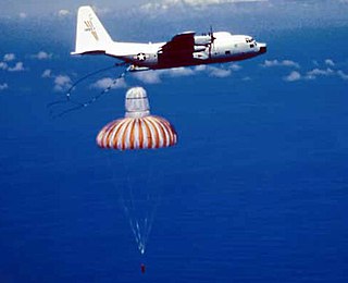
WThe Corona program was a series of American strategic reconnaissance satellites produced and operated by the Central Intelligence Agency Directorate of Science & Technology with substantial assistance from the U.S. Air Force. The Corona satellites were used for photographic surveillance of the Soviet Union (USSR), the People's Republic of China, and other areas beginning in June 1959 and ending in May 1972.
 W
WThe Corona Satellite Calibration Targets consist of 272 concrete markers embedded into the Earth's surface in and around Casa Grande, Arizona, United States. The markers were used to aid camera calibration for the US Central Intelligence Agency's Corona spy satellite program. The markers formed a square 16-by-16-mile grid, and were maintained from 1959 to 1972. Some of the original markers can still be found on satellite maps and ground inspection. See links to maps below.
 W
WThe KH-10 was the classified designation for the reconnaissance mission and equipment of the experimental Manned Orbiting Laboratory (MOL).
 W
WThe United States' National Reconnaissance Operations Center (NROC) is the focal point for the National Reconnaissance Office's current operations and for time-sensitive space-borne intelligence reporting for the United States Intelligence Community (USIC). The NROC was created in response to the September 11th terrorist attacks.