 W
WThe Southeastern Ceremonial Complex, aka S.E.C.C., is the name given to the regional stylistic similarity of artifacts, iconography, ceremonies, and mythology of the Mississippian culture that coincided with their adoption of maize agriculture and chiefdom-level complex social organization from 1200 to 1650 CE. Due to some similarities between S.E.C.C. and contemporary Mesoamerican cultures, scholars from the late 1800s to mid-1900s suspected there was a connection between the two locations. However, later research indicates the two cultures have no direct links.
 W
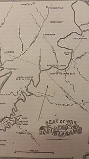
WThe Battle of Burnt Corn, also known as the Battle of Burnt Corn Creek, was an encounter between United States armed forces and Creek Indians that took place July 27, 1813 in present-day southern Alabama. The battle was part of the Creek War.
 W
WThe Battle of Calebee Creek took place on January 27, 1814, during the Creek War, in Macon County, Alabama, 50 miles (80 km) west of Fort Mitchell. General Floyd, with 1,200 Georgia volunteers, a company of cavalry and 400 friendly Yuchi, repulsed a night attack of the Red Sticks on his camp. Floyd lost so many in this hostile country that he immediately withdrew to the Chattahoochee River. Also referred to as the Battle for Camp Defiance.
 W
WThe Battle of Holy Ground, or Battle of Econochaca, was a battle fought on December 23, 1813 between the United States militia and the Red Stick Creek Indians during the Creek War. The battle took place at Econochaca, the site of a fortified encampment established in the summer of 1813 by Josiah Francis on a bluff above the Alabama River, in what is now Lowndes County, Alabama. It was one of three encampments erected by Red Stick Creeks that summer. In addition to the physical defenses, Creek prophets performed ceremonies at the site to create a spiritual barrier of protection. Hence the Creek name "Econochaca," loosely translated as holy ground, but properly translated as sacred or beloved ground.
 W
WThe Battle of Horseshoe Bend, was fought during the War of 1812 in the Mississippi Territory, now central Alabama. On March 27, 1814, United States forces and Indian allies under Major General Andrew Jackson defeated the Red Sticks, a part of the Creek Indian tribe who opposed American expansion, effectively ending the Creek War.
 W
WThe Battle of Talladega was fought between the Tennessee Militia and the Red Stick Creek Indians during the Creek War, in the vicinity of the present-day county and city of Talladega, Alabama, in the United States.
 W
WThe Battle of Tallasseehatchee was a battle fought during the War of 1812 and Creek War on November 3, 1813, in Alabama between Native American Red Stick Creeks and United States dragoons. A cavalry force commanded by Brigadier General John Coffee was able to defeat the Creek warriors.
 W
WThe Canoe Fight was a skirmish between Mississippi Territory militiamen and Red Stick warriors that took place on November 12, 1813 as part of the Creek War.
 W
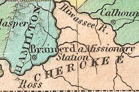
WCherokee removal, part of the Trail of Tears, refers to the forced relocation between 1836 and 1839 of an estimated 16,000 members of the Cherokee Nation and 1,000-2,000 of their slaves; from their lands in Georgia, South Carolina, North Carolina, Tennessee, and Alabama to the Indian Territory in the then Western United States, and the resultant deaths along the way and at the end of the movement of an estimated 4,000 Cherokee and unknown number of slaves.
 W
WThe Cherokee–American wars, also known as the Chickamauga Wars, were a series of raids, campaigns, ambushes, minor skirmishes, and several full-scale frontier battles in the Old Southwest from 1776 to 1795 between the Cherokee and American settlers on the frontier. Most of the events took place in the Upper South. While the fighting stretched across the entire period, there were extended periods with of little or no action.
 W
WThe Choctaw Corner is a former Native American boundary location near the modern border between Clarke and Marengo counties in Alabama, United States. It was established as the northernmost terminus for a mutually agreed upon boundary line between the Choctaw and Creek peoples during the Mississippi Territory period. This boundary line, now known as the “Old Indian Treaty Boundary,” starts at the Alabama River cut-off in southernmost Clarke County and follows a northward path through the county along the drainage divide between the Tombigbee and Alabama rivers to the Choctaw Corner, then turns ninety degrees to the west and follows the modern county-line between Clarke and Marengo to the Tombigbee River.
 W
WThe Deptford culture was an archaeological culture in southeastern North America characterized by the appearance of elaborate ceremonial complexes, increasing social and political complexity, mound burial, permanent settlements, population growth, and an increasing reliance on cultigens.
 W
WFort Cusseta was a wooden stockade built by white settlers to protect against possible Creek Indian attacks. Its ruin still exists today within the small city of Cusseta, Alabama.
 W
WThe Fort Mims massacre took place on August 30, 1813, during the Creek War, when a force of Creek Indians belonging to the Red Sticks faction, under the command of head warriors Peter McQueen and William Weatherford, stormed the fort and defeated the militia garrison. Afterward, a massacre ensued and almost all of the remaining Creek métis, white settlers, and militia at Fort Mims were killed. The fort was a stockade with a blockhouse surrounding the house and outbuildings of the settler Samuel Mims, located about 35 miles directly north of present-day Mobile, Alabama.
 W
WFort Mitchell Historic Site is a park and an archaeological site in Fort Mitchell, Alabama, that was declared a National Historic Landmark in 1990. The park features a reconstruction of the 1813 stockade fort that was an important United States military post in the Creek War, a museum with exhibits about the fort's history, and a collection of historic carriages, a restored 19th-century log home, and a visitor center.
 W
WFort Toulouse, also called Fort des Alibamons and Fort Toulouse des Alibamons, is a historic fort near the city of Wetumpka, Alabama, United States, that is now maintained by the Alabama Historical Commission. The French founded the fort in 1717, naming it for Louis-Alexandre de Bourbon, comte de Toulouse. In order to counter the growing influence of the British colonies of Georgia and Carolina, the government of French Louisiana erected a fort on the eastern border of the Louisiana Colony in what is now the state of Alabama.
 W
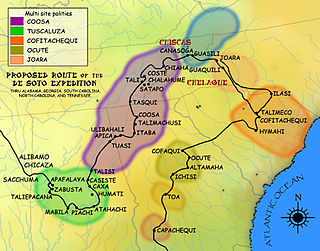
WThis is a list of sites and peoples visited by the Hernando de Soto Expedition in the years 1539–1543. In May 1539, de Soto left Havana, Cuba, with nine ships, over 620 men and 220 surviving horses and landed at Charlotte Harbor, Florida. This began his three-year odyssey through the Southeastern North American continent, from which de Soto and a large portion of his men would not return. They met many varied Native American groups, most of them bands and chiefdoms related to the widespread Mississippian culture. Only a few of these cultures survived into the seventeenth century. Others have been recorded only in the written historical accounts of de Soto's expedition.
WHillabee was an important Muscogee (Creek) town in east central Alabama before the Indian Removals of the 1830s.
 W
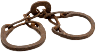
WNative Americans living in the American Southeast were enslaved through warfare and purchased by European colonists throughout the 17th, 18th, and 19th centuries, as well as held in captivity through Spanish-organized forced labor systems in Florida. Emerging colonies in Virginia, Carolina, and Georgia imported Native Americans and incorporated them into chattel slavery systems, where they intermixed with slaves of African descent, who would come to outnumber them. Their demand for slaves affected communities as far west as present-day Illinois and the Mississippi River and as far south as the Gulf Coast. The trade in enslaved Native Americans sent tens of thousands of them outside the region to New England and the Caribbean as a profitable export.
 W
WThe Liddell Archeological Site is a prehistoric Native American site in Wilcox County, Alabama. The site covers 50 acres (20 ha) and shows evidence of human occupation from 9000 BC to 1800 AD. It is best known for its Mississippian artifacts, primarily from the Burial Urn Culture period. The site was first documented in the 1960s, when the United States Army Corps of Engineers constructed Millers Ferry Lock and Dam on the Alabama River, creating the William "Bill" Dannelly Reservoir. The Liddell, Stroud, and Hall families donated the site to Auburn University after its discovery. It was added to the National Register of Historic Places on November 17, 1978.
 W
WMabila was a small fortress town known to the paramount chief Tuskaloosa in 1540, in a region of present-day central Alabama. The exact location has been debated for centuries, but southwest of present-day Selma, Alabama, is one possibility.
 W
WMoundville Archaeological Site, also known as the Moundville Archaeological Park, is a Mississippian culture archaeological site on the Black Warrior River in Hale County, near the city of Tuscaloosa, Alabama. Extensive archaeological investigation has shown that the site was the political and ceremonial center of a regionally organized Mississippian culture chiefdom polity between the 11th and 16th centuries. The archaeological park portion of the site is administered by the University of Alabama Museums and encompasses 185 acres (75 ha), consisting of 29 platform mounds around a rectangular plaza.
WMuklassa, also known as Amooklasah Town, is the site of a former Upper Creek village in modern Montgomery County, Alabama. The site covers 52 acres (21 ha) and was added to the National Register of Historic Places on August 28, 1973.
WNanna Hubba Bluff is a bluff above the Tombigbee River near Calvert in northeastern Mobile County, Alabama, United States. The historic site is known to have been occupied by Native Americans at least as far back as 1000 BC, but gained its name from the historic-era Nanibas tribe. The Nanibas (‘fish-eaters’) are believed by scholars to have been a Choctaw people. They occupied a village here during the early 18th century, until they moved downstream to the vicinity of Fort Louis de la Mobile and were absorbed into the Mobile tribe. Following the relocation of the Nanibas, the bluff came to be settled by early European settlers. During the American Civil War the Confederacy had shipyards at the site. It was added to the National Register of Historic Places on October 1, 1974, due to its historical importance. Nanna Hubba Bluff was acquired by ThyssenKrupp in 2007, with the company building a new US$4.65 billion stainless and carbon steel facility on the site.
 W
WThe Pensacola culture was a regional variation of the Mississippian culture along the Gulf Coast of the United States that lasted from 1100 to 1700 CE. The archaeological culture covers an area stretching from a transitional Pensacola/Fort Walton culture zone at Choctawhatchee Bay in Florida to the eastern side of the Mississippi River Delta near Biloxi, Mississippi, with the majority of its sites located along Mobile Bay in the Mobile-Tensaw River Delta. Sites for the culture stretched inland, north into the southern Tombigee and Alabama River valleys, as far as the vicinity of Selma, Alabama.
 W
WThe Stanfield-Worley Bluff Shelter, located on private property in Colbert County in northwestern Alabama, United States, is one of the most important prehistoric sites excavated in the state due to the archeological evidence deposited by the Paleo-Indians who once occupied the rock shelter. Lying in Sanderson Cove along a tributary of Cane Creek approximately seven miles (11 km) south of the Tennessee Valley, the shelter and the high bluffs of the surrounding valley provided a well-protected environment for the Native American occupants.
 W
WTawasa is an extinct Native American language. Ostensibly the language of the Tawasa people of what is now Alabama, it is known exclusively through a word list attributed to a Tawasa named Lamhatty, collected in 1707.
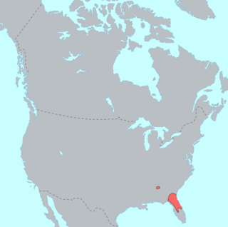
WTimucua is a language isolate formerly spoken in northern and central Florida and southern Georgia by the Timucua peoples. Timucua was the primary language used in the area at the time of Spanish colonization in Florida. Differences among the nine or ten Timucua dialects were slight, and appeared to serve mostly to delineate band or tribal boundaries. Some linguists suggest that the Tawasa of what is now northern Alabama may have spoken Timucua, but this is disputed.
WThe Tombigbee District, also known as the Tombigbee, was one of two areas, the other being the Natchez District, that were the first in what was West Florida to be colonized by British subjects from the Thirteen Colonies and elsewhere. This later became the Mississippi Territory as part of the United States. The district was also the first area to be opened to white settlement in what would become the state of Alabama, outside of the French colonial outpost of Mobile on the Gulf Coast. The Tombigbee and Natchez districts were the only areas populated by whites in the Mississippi Territory when it was formed by the United States in 1798.
 W
WThe Trail of Tears was a series of forced relocations of approximately 60,000 Native Americans between 1830 and 1850 by the United States government. Members of the Cherokee, Muscogee (Creek), Seminole, Chickasaw, and Choctaw nations were forcibly removed from their ancestral homelands in the Southeastern United States to areas to the west of the Mississippi River that had been designated as 'Indian Territory'. The forced relocations were carried out by government authorities following the passage of the Indian Removal Act in 1830. The Cherokee removal in 1838 was brought on by the discovery of gold near Dahlonega, Georgia in 1828, resulting in the Georgia Gold Rush.
 W
WTuskaloosa was a paramount chief of a Mississippian chiefdom in what is now the U.S. state of Alabama. His people were possibly ancestors to the several southern Native American confederacies who later emerged in the region. The modern city of Tuscaloosa, Alabama, is named for him.
 W
WYuchi Town Site, or Yuchi Town, is a late prehistoric and historic era archaeological site showing occupation of both the Apalachicola and of Yuchi tribes. The site is located in a remote area of Fort Benning, Russell County, Alabama. The Yuchi Town Site is an example of historic Native American cultures adopting various strategies to maintain their cultural integrity in the face of European colonization and the expansion of the United States. It was declared a National Historic Landmark in 1996.