 W
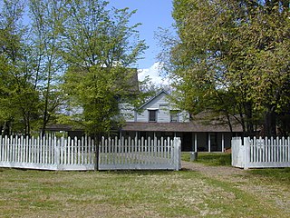
WAnderson Marsh State Historic Park is a California State Historic Park and nature reserve preserving a tule marsh, archaeological sites of the Pomo people, and historic ranch structures. It is located in Lake County, California, USA. Anderson Marsh is located at the head of Cache Creek on the southeast corner of Clear Lake, the largest natural lake completely within the borders of California. The park is between the cities of Lower Lake and Clearlake on State Route 53, north of Calistoga in the wine country. The park is open year-round.
 W
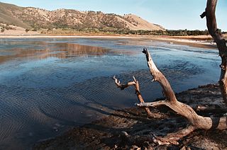
WThe Borax Lake Site, also known as the Borax Lake—Hodges Archaeological Site and designated by the Smithsonian trinomial CA-LAK-36, is a prehistoric archaeological site near Clearlake, California. The site, a deeply stratified former lakeshore, contains evidence of the earliest known period of human habitation in what is now California, dating back 12,000 years. A portion of the site, designated a National Historic Landmark in 2006, is owned and preserved by the Archaeological Conservancy.
 W
WBurro Flats Painted Cave (BFPC) is located near Burro Flats, in the Simi Hills of eastern Ventura County, California, United States. The Chumash-style "main panel" and the surrounding 25-acres were listed on the National Register of Historic Places in 1976, with a boundary decrease in 2020. The main panel includes dozens of pictographs in a variety of colors. The cave is in the mountains, near the bi-lingual Chumash/Fernandeno village of Huwam/Jucjauynga. Burro Flats Painted Cave and the rest of the former Santa Susana Field Laboratory are not accessible to the public.
 W
WBurton Mound is a California Historical Landmark located in Santa Barbara, California, in the United States. It is believed to be a former Native American village that was discovered in 1542 by Juan Rodríguez Cabrillo. Historically known as Syujtun, it was also visited and documented by Juan Crespí, Gaspar de Portolà, and eventually Don Luís Burton, the latter who purchased the property in 1860. The California Department of Parks and Recreation has acknowledged that Burton Mound has "yielded some of the most important archeological evidence found in California".
 W
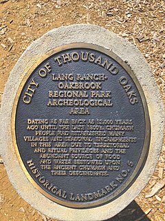
WChumash Indian Museum is a Native American Interpretive Center in northeast Thousand Oaks, California. It is the site of a former Chumash village, known as Sap'wi. It is located in Oakbrook Regional Park, a 432-acre park which is home to a replica of a Chumash village and thousand year-old Chumash pictographs. The pictographs by nearby Birthing Cave are not open to the public, but can be observed on docent-led tours. Chumash people inhabited the village 10,000 years ago.
 W
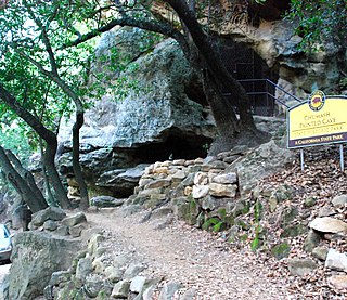
WChumash Painted Cave State Historic Park is a unit in the state park system of California, preserving a small sandstone cave adorned with rock art attributed to the Chumash people. Adjoining the small community of Painted Cave, the site is located about 2 miles (3.2 km) north of California State Route 154 and 11 miles (18 km) northwest of Santa Barbara. The 7.5-acre (3.0 ha) park was established in 1976.
 W
WEast Bay Walls, also known as the Berkeley Mystery Walls, is a misnomer, as there are many such crude walls throughout the hills surrounding the San Francisco Bay Area. In places, they are up to a meter high and a meter wide and are built without mortar; the walls run in sections anywhere from a few meters to over a half mile long. The rocks used to construct the walls are a variety of sizes. Some are basketball-sized rocks, while others are large sandstone boulders weighing a ton or more. Parts of the wall seem to be just piles of rocks, but in other places it appears the walls were carefully constructed. The exact age of the walls is unknown, but they have an old appearance. Many of the formations have sunk far into the earth, and are often completely overgrown with different plants.
 W
WThe El Paso Mountains Wilderness was created in 1994 and now has a total of 23,780 acres (96.2 km2). All of the wilderness is in the northern Mojave Desert in eastern Kern County, California and is managed by the Bureau of Land Management. It is located south of Ridgecrest, California.
 W
WThe Emeryville Shellmound, in Emeryville, California, is a sacred burial site of the Ohlone people, a once-massive archaeological shell midden deposit. It was one of a complex of five or six mounds along the mouth of the perennial Temescal Creek, on the east shore of San Francisco Bay between Oakland and Berkeley. It was the largest of the over 425 shellmounds that surrounded San Francisco Bay. The site of the Shellmound is now a California Historical Landmark (#335).
 W
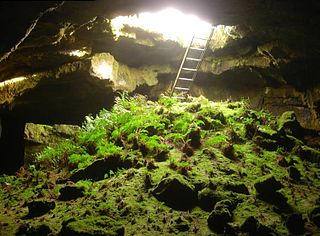
WThe Fern Cave Archeological Site, in Lava Beds National Monument near Tule Lake, California, was listed on the National Register of Historic Places in 1975.
 W
WFort Ross, originally Fortress Ross, is a former Russian establishment on the west coast of North America in what is now Sonoma County, California. It was the hub of the southernmost Russian settlements in North America from 1812 to 1841. It has been the subject of archaeological investigation and is a California Historical Landmark, a National Historic Landmark, and on the National Register of Historic Places. It is part of California's Fort Ross State Historic Park.
 W
WThe Frolic was a brig which sank northeast of Point Cabrillo, near Caspar, California. Historians have called it "the most significant shipwreck on the west coast". Its shipwreck site was listed on the National Register of Historic Places as Frolic (brig) in 1991.
 W
WJoshua Tree National Park is an American national park in southeastern California, east of Los Angeles and San Bernardino, near Palm Springs. It is named for the Joshua trees native to the Mojave Desert. Originally declared a national monument in 1936, Joshua Tree was redesignated as a national park in 1994 when the U.S. Congress passed the California Desert Protection Act. Encompassing a total of 790,636 acres – slightly larger than the state of Rhode Island – the park includes 429,690 acres of designated wilderness. Straddling San Bernardino and Riverside Counties, the park includes parts of two deserts, each an ecosystem whose characteristics are determined primarily by elevation: the higher Mojave Desert and the lower Colorado Desert. The Little San Bernardino Mountains traverse the southwest edge of the park.
 W
WLava Beds National Monument is located in northeastern California, in Siskiyou and Modoc counties. The monument lies on the northeastern flank of Medicine Lake Volcano and has the largest total area covered by a volcano in the Cascade Range.
 W
WMission San José is a Spanish mission located in the present-day city of Fremont, California. It was founded on June 11, 1797, by the Franciscan order and was the fourteenth Spanish mission established in California. The mission is the namesake of the Mission San José district of Fremont, which was an independent town subsumed into the city when it was incorporated in 1957. The Mission entered a long period of gradual decline after Mexican secularization act of 1833. After suffering decline, neglect and earthquakes most of the mission was in ruins. Restoration efforts in the intervening periods have reconstructed many of the original structures. The old mission church remains in use as a chapel of Saint Joseph Catholic Church, a parish of the Diocese of Oakland. The museum also features a visitor center, museum, and slide show telling the history of the mission.
 W
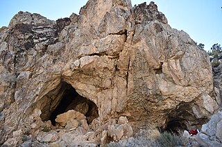
WMitchell Caverns, within the Mitchell Caverns Natural Preserve, is a pair of solution limestone caves, located on the east side of the Providence Mountains at an elevation of 4,300 feet (1,300 m), within the Providence Mountains State Recreation Area. It is located in the Mojave Desert, in San Bernardino County, California.
 W
WArcheological Site 4-SK-4, in Tulelake, California, near Macdoel, California, is a stratified archeological site that was a hunter-gatherer village on the west shores of the Lower Klamath Lake. The site is located in the heart of the Klamath Basin wetlands, west of Indian Tom Lake. It has also been known as Nightfire Island and as Sheepy Island. Modern Modocs have called the island Shapasheni, meaning "where the sun and moon live", or "home of the sun and the moon.
 W
WPainted Rock is a smooth horseshoe-shaped marine sandstone rock formation with pictograph rock art about 250 feet across and 45 feet tall near Soda Lake within the Carrizo Plain National Monument on the southwest side of the northern Carrizo Plain, west of Bakersfield and about 70 miles (110 km) east of San Luis Obispo and 45 miles (72 km) west of Taft, in California, United States.
 W
WThe Petroglyph Point is an archaeological site within the Lava Beds National Monument, located southeast of Tulelake, California. Petroglyph Point contains one of the largest panels of Native American rock art in the United States. The petroglyphs are carved along the face of a former island of ancient Tule Lake, in a region historically of the Modoc people territory. The Petroglyph Point Archeological Site was listed on the National Register of Historic Places in 1975, while the Lava Beds National Monument Archeological District was listed in March 1991.
 W
WEl Presidio Real de Santa Bárbara, also known as the Royal Presidio of Santa Barbara, is a former military installation in Santa Barbara, California, USA. The presidio was built by Spain in 1782, with the mission of defending the Second Military District in California. In modern times, the Presidio serves as a significant tourist attraction, museum and an active archaeological site as part of El Presidio de Santa Barbara State Historic Park.
 W
WPuvunga is an ancient village and sacred site of the Tongva nation, who are the indigenous peoples of the region around Los Angeles, California, and the Acjachemen who are the indigenous people of Orange County. The Tongva referred to Puvunga as the "place of emergence" and it is where they believed "their world and their lives began." Puvunga is believed to be the birthplace of Chingishnish in Tongva mythology, "the prophet or deity who appears at Puvunga after Wiyot, the creator, has been killed, and tells the assembly what they must do in order to feed themselves."
 W
WReinhardt Canyon is located in the Lakeview Mountains, just west of Hemet in Riverside County, California.
 W
WSan Onofre State Beach is a 3,000-acre (1,214 ha) state park in San Diego County, California. The beach is 3 miles (5 km) south of San Clemente on Interstate 5 at Basilone Road. The state park is leased to the state of California by the United States Marine Corps. Governor Ronald Reagan established San Onofre State Beach in 1971. With over 2.5 million visitors per year, it is one of the five most-visited state parks in California, hosting swimmers, campers, kayakers, birders, fishermen, bicyclists, sunbathers, surfers, and the sacred Native American site of Panhe. It is named after the fourth-century saint Onuphrius.
 W
WThe Santa Clara River is 83 miles (134 km) long, and is one of the most dynamic river systems in Southern California. The river drains parts of four ranges in the Transverse Ranges System north and northwest of Los Angeles, then flows west onto the Oxnard Plain and into the Santa Barbara Channel of the Pacific Ocean.
 W
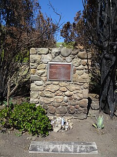
WThe Santa Gertrudis Asistencia, also known as the Santa Gertrudis Chapel, was an asistencia ("sub-mission") to the Mission San Buenaventura, part of the system of Spanish missions in Las Californias—Alta California. Built at an unknown date between 1792 and 1809, it was located approximately five miles from the main mission, inland and upstream along the Ventura River. The site was buried in 1968 by the construction of California State Route 33. Prior to the freeway's construction, archaeologists excavated and studied the site. A number of foundation stones were moved and used to create the Santa Gertrudis Asistencia Monument which was designated in 1970 as Ventura County Historic Landmark No. 11.
 W
WThe Santa Monica Mountains is a coastal mountain range in Southern California, paralleling the Pacific Ocean. It is part of the Transverse Ranges. Because of its proximity to densely populated regions, it is one of the most visited natural areas in California. Santa Monica Mountains National Recreation Area is located in this mountain range.
 W
WSanta Rosa Island is the second largest of the Channel Islands of California at 53,195 acres. Santa Rosa is located about 26 miles (42 km) off the coast of Santa Barbara, California in Santa Barbara County and is part of Channel Islands National Park.
 W
WKuruvungna Springs are a pair of springs located on the campus of University High School in Los Angeles, California.
 W
WShalawa Meadow is a 3-acre (0.012 km2) seaside meadow used in ancient times as a burial site by the Chumash people, adjoining a once large Chumash community about 5 miles east of Santa Barbara, California in the community of Montecito.
 W
WThe Spanish missions in California comprise a series of 21 religious outposts or missions established between 1769 and 1833 in what is now the U.S. state of California. Founded by Catholic priests of the Franciscan order to evangelize the Native Americans, the missions led to the creation of the New Spain province of Alta California and were part of the expansion of the Spanish Empire into the most northern and western parts of Spanish North America.
 W
WTriangle Marsh is a wetland of the San Francisco Bay, situated at the base of Ring Mountain at the north end of the Tiburon Peninsula in Marin County, California.