 W
WThe Bab al-Hawa Border Crossing is an international border on the Syria-Turkey border. It connects the Syrian M45 and the Turkish D827 highways, between the cities of İskenderun and Idlib, and is known for its long lines of trucks and buses. The closest town on the Turkish side of the border is Reyhanlı in Hatay Province, and the closest towns on the Syrian side are ad-Dana and Atarib. The crossing is the site of a 6th-century triumphal arch.
 W
WBanias is an ancient site that developed around a spring once associated with the Greek god Pan. It is located at the foot of Mount Hermon, north of the Golan Heights. The spring is the source of the Banias River, one of the main tributaries of the Jordan River. Archaeologists uncovered a shrine dedicated to Pan and related deities, and the remains of an ancient city founded sometime after the conquest by Alexander the Great and inhabited until 1967; the ancient city was mentioned in the Gospels of Matthew and Mark by the name of Caesarea Philippi.
 W
WBurqush or Burkush is an archaeological site situated 30 kilometres (19 mi) west of Damascus, Syria.
 W
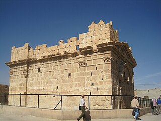
WCaesarea Philippi was an ancient Roman city located at the southwestern base of Mount Hermon. It was adjacent to a spring, grotto, and related shrines dedicated to the Greek god Pan. Now nearly uninhabited, Caesarea is an archaeological site in the Golan Heights.
WDeir Ali is a small town in southern Syria, administratively part of the Rif Dimashq Governorate. According to the Syria Central Bureau of Statistics, Deir Ali had a population of 4,368 in the 2004 census. Its inhabitants are predominantly members of the Druze community.
WDibsi Faraj is an archaeological site on the right bank of the Euphrates in Aleppo Governorate (Syria). The site was excavated as part of a larger international effort coordinated by UNESCO to excavate as many archaeological sites as possible in the area that would be flooded by the reservoir created by the Tabqa Dam, which was being built at that time. An initial, small archaeological sounding was done at Dibsi Faraj by the Syrian Department of Antiquities in 1971. Following this investigation, the site was excavated between 1972 and 1974 as part of a joint operation of the Dumbarton Oaks Center for Byzantine Studies and the Kelsey Museum of Archaeology at the University of Michigan under the direction of Richard P. Harper. Since then, the site has disappeared under the rising waters of Lake Assad, the reservoir created by the Tabqa Dam.
 W
WDumeir, also Dumair, Damir and Dumayr is a city located 40 kilometers north-east of Damascus, Syria.
 W
WDura-Europos, also spelled Dura-Europus, was a Hellenistic, Parthian and Roman border city built on an escarpment 90 metres above the right bank of the Euphrates river. It is located near the village of Salhiyé, in today's Syria. In 113 BC, Parthians conquered the city, and held it, with one brief Roman intermission, until 165 AD. Under Parthian rule, it became an important provincial administrative centre. The Romans decisively captured Dura-Europos in 165 AD and greatly enlarged it as their easternmost stronghold in Mesopotamia, until it was captured by the Sasanian Empire after a siege in 256–57 AD. Its population was deported, and after it was abandoned, it was covered by sand and mud and disappeared from sight.
 W
WHarran al-'Awamid is a town in southern Syria, administratively part of the Rif Dimashq Governorate, located southeast of Damascus. It is situated on a plain that stretches to the marshes of Bahrat al-Qibliyah along the boundary of the fertile Ghouta region to the west, to the north of the Hauran. Nearby localities include al-Kafrin and Judaydat al-Khas to the south, al-Atibah to the northeast, al-Abbadeh and al-Qisa to the north, al-Ahmadiyah to the northwest, Sakka to the west and Ghasulah and al-Ghizlaniyah to the southwest.
 W
WHosn Suleiman, a Syrian village, is found on the slope of the Al-Nabi Saleh mountain at an altitude 950 m, at a distance of 20 km from Duraykish and 56 km from Tartous.
WJdeidat Yabous, previously known as Ainkania, is a village situated 45 kilometres (28 mi) west of Damascus, Syria. According to the Syria Central Bureau of Statistics, the village had a population of 994 in the 2004 census.
WKafr Hawr is a Syrian village situated 35 kilometres (22 mi) southwest of Damascus. According to the Syria Central Bureau of Statistics, the village had a population of 2,957 in the 2004 census.
WLaodicea ad Libanum, also transliterated as Laodiceia or Laodikeia; also Cabrosa, Scabrosa and Cabiosa Laodiceia – was an ancient Hellenistic city on the Orontes in Coele-Syria, the remains of which are found approximately 25 km southwest of Homs, Syria. The city is mentioned by Strabo as the commencement of the Marsyas Campus, which extended along the west side of the Orontes, near its source. It is called Cabiosa Laodiceia by Ptolemy, and gives its name to a district Laodicene (Laodikênê), in which he places two other towns, Paradisus (Paradeisos) and Jabruda (Iabmouda). Pliny, among other people of Syria, reckons ad orientem Laodicenos, qui ad Libanum cognominantur.
 W
WLaodicea was a port city and an important colonia of the Roman Empire in ancient Syria, located near the modern city of Latakia. It was also called Laodicea in Syria or Laodicea ad mare. For a short period of time under Septimius Severus, it became the capital of Roman Syria, and subsequently, it became the capital of the Eastern Roman province of Theodorias from 528 AD until 637 AD.
 W
WLatakia is the principal port city of Syria, as well as the capital of the Latakia Governorate. Historically, it has also been known as Laodicea in Syria or Laodicea ad Mare. In addition to serving as a port, the city is a manufacturing center for surrounding agricultural towns and villages. According to the 2004 official census, the population of the city is 383,786, Its population greatly increased as a result of the ongoing Syrian Civil War due to the influx of refugees from rebel held areas. It is the 4th-largest city in Syria after Aleppo, Damascus and Homs, and it borders Tartus to the south, Hama to the east, and Idlib to the north while Cape Apostolos Andreas, the most north-eastern tip of Cyprus is about 68 miles (109 km) away.
WAl-Mushannaf is a village in southern Syria, administratively part of the al-Suwayda Governorate, located northeast of al-Suwayda. Nearby localities include Tarba to the north, Shahba and Salkhad to the northwest, Qanawat to the west and al-Kafr to the southwest. According to the Syria Central Bureau of Statistics (CBS), al-Mushannaf had a population of 2,581 in the 2004 census. The town is also the administrative center of the al-Mushannaf nahiyah of the al-Suwayda District consisting of 14 villages with a combined population of 17,134.
WPaltus or Paltos is a ruined city. It was also a bishopric, a suffragan of Seleucia Pieria in the Roman province of Syria Prima, that, no longer being a residential see, is included in the Catholic Church's list of titular sees.
WQasr Chbib is a complex of two Roman temples situated a few hundred meters from the summit of Mount Hermon. Officially in the Quneitra District of Syria, Web mapping shows the ruins to be in the Hasbaya District of the Nabatieh Governorate in Lebanon.
WRakhlah, previously known as Zenopolis, is a village situated 31 kilometres (19 mi) west of Damascus, Syria. also known as "The town of Wine and Poetry".
WRas al-Bassit, the classical Posidium or Posideium, is a small town in Syria named for a nearby cape. It has been occupied since at least the late Bronze Age and was a fortified port under Greek and Roman rule. Herodotus—although not later classical geographers—made it the northwestern point of Syria. Its beaches have a distinctive black sand and are a popular resort destination within Syria.
 W
WResafa, also sometimes spelled Rusafa, and known in the Byzantine era as Sergiopolis and briefly as Anastasiopolis, was a city located in the Roman province of Euphratensis, in modern-day Syria. It is an archaeological site situated southwest of the city of Raqqa and the Euphrates.
WRhesaina (Rhesaena) was a city in the late Roman province of Mesopotamia Secunda and a bishopric that was a suffragan of Dara.
WSlaim is a village in southern Syria, administratively part of the al-Suwayda Governorate, located north of al-Suwayda. Nearby localities include Attil to the west, Mardak and Shahba to the north and Qanawat to the southeast. According to the Syria Central Bureau of Statistics (CBS), Salim had a population of 2,129 in the 2004 census.
WSarmada is a town in the Harem District, Idlib Governorate of Syria. It is in the extreme northwest of Syria near the border with Turkey.
 W
WShahba is a city located 87 km south of Damascus in the Jabal el Druze in As-Suwayda Governorate of Syria, but formerly in the Roman province of Arabia Petraea. Known in Late Antiquity as Philippopolis , the city was the seat of a Bishopric, which remains a Latin titular see.
WShaqqa or Shakka is a Syrian town in As Suwayda Governorate in southern Syria, whose some 8,000 inhabitants are mainly Druze, descendants of those who migrated here from Lebanon in the 18th and 19th centuries.
WSura (Suriya), was an ancient city on the Euphrates River in northern Syria, today on a site 25 km west of Raqqa and 35 km north of Resafa. In the Roman Empire, Sura was a fortress city in the Roman province of Syria, and later on, in the Euphratensis.
 W
WAs-Suwayda, also spelled Sweida or Swaida, is a mainly Druze city located in southwestern Syria, close to the border with Jordan.
 W
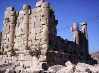
WThe Temples of Mount Hermon are around thirty Roman shrines and Roman temples that are dispersed around the slopes of Mount Hermon in Lebanon, Israel and Syria. A few temples are built on former buildings of the Phoenician & Hellenistic era, but nearly all are considered to be of Roman construction and were largely abandoned during the persecution of pagans in the late Roman Empire.