 W
WThe Territory of Montana was an organized incorporated territory of the United States that existed from May 26, 1864, until November 8, 1889, when it was admitted as the 41st state in the Union as the state of Montana.
 W
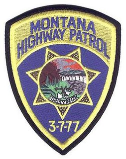
W3-7-77 was the symbol used by the Montana Vigilantes in Virginia City, Montana. People who found the numbers '3-7-77' painted on their tent or cabin knew that they had better leave the area or expect to be on the receiving end of vigilantism. The numbers are used on the shoulder patch of the Montana Highway Patrol, who claim they do not know the original meaning of the symbol, though the Association of Montana Troopers web site says "Regardless of its meaning, however, 3-7-77 is emblematic of the first organized law enforcement in Montana. The Montana Highway Patrol, in adopting this early symbol, honors the first men in the Montana Territory who organized for the safety and welfare of the people. For that same reason, the Association of Montana Troopers has carried on that tradition by placing the legendary 3-7-77 on their patch as well."
 W
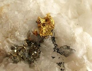
WThe Atlantic Cable Quartz Lode is a gold mine in Deer Lodge County, Montana. The mine is located in the southwestern area of Montana, between Drummond and Anaconda along the Pintler Scenic Route on Montana Highway 1, east of Georgetown Lake.
 W
WThe Big Sky is a 1947 Western novel by A. B. Guthrie, Jr. It is the first of six novels in Guthrie's sequence dealing with the Oregon Trail and the development of Montana from 1830, the time of the mountain men, to "the cattle empire of the 1880s to the near present." The first three books of the six in chronological story sequence — The Big Sky, The Way West, and Fair Land, Fair Land — are in themselves a complete trilogy, starting in the 1830s and ending in the 1870s.
 W
WThe Bridger Trail, also known as the Bridger Road and Bridger Immigrant Road, was an overland route connecting the Oregon Trail to the gold fields of Montana. Gold was discovered in Virginia City, Montana in 1863, prompting settlers and prospectors to find a trail to travel from central Wyoming to Montana. In 1863, John Bozeman and John Jacobs scouted the Bozeman Trail, which was a direct route to the Montana gold fields through the Powder River Country. At the time the region was controlled by the Sioux, Cheyenne and Arapaho, who stepped up their raids in response to the stream of settlers along the trail.
 W
WThe Cook–Folsom–Peterson Expedition of 1869 was the first organized expedition to explore the region that became Yellowstone National Park. The privately financed expedition was carried out by David E. Folsom, Charles W. Cook and William Peterson of Diamond City, Montana, a gold camp in the Confederate Gulch area of the Big Belt Mountains east of Helena, Montana. The journals kept by Cook and Folsom, as well as their personal accounts to friends were of significant inspirational value to spur the organization of the Washburn-Langford-Doane Expedition which visited Yellowstone in 1870.
 W
WThe Copper Kings were the three industrialists William A. Clark, Marcus Daly, and F. Augustus Heinze. They were known for the epic battles fought in Butte, Montana, and the surrounding region, during the Gilded Age, over control of the local copper mining industry, the fight that had ramifications for not only Montana, but the United States as a whole.
 W
WCow Creek is a tributary of the Missouri River, approximately 35 miles (56 km) long, in north central Montana in the United States. Cow Creek rises in the southern foothills of the Bear Paw Mountains in western Blaine County and flows east and then south, joining the Missouri approximately 25 air miles (40 km) northeast of Winifred, Montana—or 22 miles (35 km) upstream from the Fred Robinson Bridge.
 W
WCow Island lies in a left turning bend of the Missouri River, in the area known as the Missouri River Breaks. The island is formed by sediments that are seasonally washed out from the mouths of Cow Creek and Bull Creek, which enter the Missouri River just upstream from Cow Island. The island is about 1.2 miles long and averages about 150 yards in width. It is located in extreme northern Fergus County, but lies across the river from extreme southern Blaine County, to its east.
 W
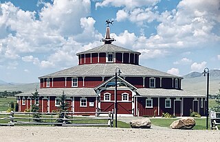
WThe Doncaster Round Barn, also called "Bayers' Barn" and "the Round Barn at Twin Bridges" is a three-story, wood framed round barn located about 1.5 miles (2.4 km) north of Twin Bridges, Montana. Built about 1882 by mining entrepreneur Noah Armstrong to house his race horses, and featuring a 20 feet (6.1 m)-wide indoor circular aisle that was used for exercising horses, it is a National Register of Historic Places property notable for its unique architecture and as the birthplace of the Thoroughbred racehorse, Spokane, winner of the 1889 Kentucky Derby.
 W
WFair Land, Fair Land is a 1982 Western novel by A. B. Guthrie, Jr. It is one in a sequence of six books dealing with the Oregon Trail and the development of Montana from 1830, the time of the mountain men, to "the cattle empire of the 1880s to the near present".
 W
WThe Territory of Idaho was an organized incorporated territory of the United States that existed from March 3, 1863, until July 3, 1890, when the final extent of the territory was admitted to the Union as Idaho.
 W
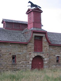
WThe J. C. Adams Stone Barn is a historic Romanesque Revival barn constructed of stone and wood located about 1 mile (1.6 km) northeast of the town of Sun River, Montana, in the United States. It is just south of U.S. Route 89. It is the only Romanesque Revival stone barn in the United States located west of the Mississippi River. Chere Jiusto, Christine Brown, and Tom Ferris of the Montana Historical Society have described the Adams Stone Barn as "one of Montana's most-beloved and best-known landmark barns." The structure was added to the National Register of Historic Places on January 12, 1979.
 W
WSpanish Louisiana was a governorate and administrative district of the Viceroyalty of New Spain from 1762 to 1801 that consisted of a vast territory in the center of North America encompassing the western basin of the Mississippi River plus New Orleans. The area had originally been claimed and controlled by France, which had named it La Louisiane in honor of King Louis XIV in 1682. Spain secretly acquired the territory from France near the end of the Seven Years' War by the terms of the Treaty of Fontainebleau (1762). The actual transfer of authority was a slow process, and after Spain finally attempted to fully replace French authorities in New Orleans in 1767, French residents staged an uprising which the new Spanish colonial governor did not suppress until 1769. Spain also took possession of the trading post of St. Louis and all of Upper Louisiana in the late 1760s, though there was little Spanish presence in the wide expanses of the "Illinois Country".
 W
WThe Louisiana Purchase was the acquisition of the territory of Louisiana by the United States from France in 1803. In return for fifteen million dollars, or approximately eighteen dollars per square mile, the United States nominally acquired a total of 828,000 sq mi. However, France only controlled a small fraction of this area, with most of it inhabited by American Indians; for the majority of the area, what the United States bought was the "preemptive" right to obtain Indian lands by treaty or by conquest, to the exclusion of other colonial powers. The total cost of all subsequent treaties and financial settlements over the land has been estimated to be around 2.6 billion dollars.
 W
WThe Territory of Louisiana or Louisiana Territory was an organized incorporated territory of the United States that existed from July 4, 1805, until June 4, 1812, when it was renamed the Missouri Territory. The territory was formed out of the District of Louisiana, which consisted of the portion of the Louisiana Purchase north of the 33rd parallel.
 W
WThe Territory of Missouri was an organized incorporated territory of the United States that existed from June 4, 1812 until August 10, 1821. In 1819, the Territory of Arkansas was created from a portion of its southern area. In 1821, a southeastern portion of the territory was admitted to the Union as the State of Missouri, and the rest became unorganized territory for several years.
 W
WThe fur trade in Montana was a major period in the area's economic history from about 1800 to the 1850s. It also represents the initial meeting of cultures between indigenous peoples and those of European ancestry. British and Canadian traders approached the area from the north and northeast focusing on trading with the indigenous people, who often did the trapping of beavers and other animals themselves. American traders moved gradually up the Missouri River seeking to beat British and Canadian traders to the profitable Upper Missouri River region.
 W
WThe Territory of Nebraska was an organized incorporated territory of the United States that existed from May 30, 1854, until March 1, 1867, when the final extent of the territory was admitted to the Union as the State of Nebraska. The Nebraska Territory was created by the Kansas–Nebraska Act of 1854. The territorial capital was Omaha. The territory encompassed areas of what is today Nebraska, Wyoming, South Dakota, North Dakota, Colorado, and Montana.
 W
WThe Pacific Fur Company (PFC) was an American fur trade venture wholly owned and funded by John Jacob Astor that functioned from 1810 to 1813. It was based in the Pacific Northwest, an area contested over the decades between the United Kingdom of Great Britain and Ireland, the Spanish Empire, the United States of America and the Russian Empire.
 W
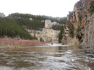
WSmith River State Recreational Waterway, popularly known as the Smith River State Park, is a protected river corridor and "virtual park" owned and operated by the state of Montana in the United States. The site is not officially a state park, but rather a State Recreational Waterway and managed River Corridor. The park consists of the state-owned Smith River; a Montana Department of Fish, Wildlife and Parks (FWP) put-in access point, Camp Baker; 27 FWP-owned and -leased boat camps on the shore of the river; and the FWP-owned Eden Bridge take-out point. Little of the area is owned by FWP. Much of the surrounding shoreline is owned by the United States Forest Service, United States Bureau of Land Management, and private owners. Through management agreements with other government agencies and private landowners, FWP manages the 58.9-mile (94.8 km) Smith River Corridor as a "virtual state park". The Smith River is the only river in the state of Montana where a permit is required to boat or float on the river.
 W
WStevensville is a town in Ravalli County, Montana, United States. The population was 1,809 at the 2010 census.
 W
WThe following chronology traces the territorial evolution of the U.S. State of Montana.
 W
WTower Rock State Park is a state park near the community of Cascade in the U.S. state of Montana in the United States. The centerpiece of the park is Tower Rock, a 424-foot (129 m)-high rock formation which marks the entrance to the Missouri River Canyon in the Adel Mountains Volcanic Field. It was well known to Native Americans, and considered a sacred place by the Piegan Blackfeet. Tower Rock received its current name when Meriwether Lewis of the Lewis and Clark Expedition visited the site in 1805. Railroad and highway development in the late 1800s and 1900s skirted Tower Rock, but the landform itself remained pristine. The 87.2 acres (0.353 km2) encompassing Tower Rock was added to the National Register of Historic Places on March 18, 2002. The 140-acre (0.57 km2) Tower Rock State Park was created around the National Historic Site in 2004.
 W
WThe Treaty of Hellgate was signed in Hellgate on July 16, 1855 between Indian commissioner Isaac Stevens and the Native American tribes located in western Montana. The treaty was ratified by Congress, signed by President James Buchanan, and proclaimed on April 18, 1859.
 W
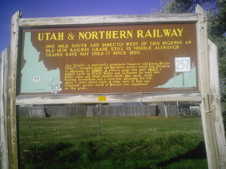
WThe Utah & Northern Railway is a defunct railroad that was operated in the Utah Territory and later in the Idaho Territory and Montana Territory in the western United States during the 1870s and 1880s. It was the first railroad in Idaho and in Montana.
 W
WThe Washburn Expedition of 1870 explored the region of northwestern Wyoming that two years later became Yellowstone National Park. Led by Henry Washburn and Nathaniel P. Langford, and with a U.S. Army escort headed by Lt. Gustavus C. Doane, the expedition followed the general course of the Cook–Folsom–Peterson Expedition made the previous year.
 W
WThe Way West is a 1949 western novel by A. B. Guthrie, Jr. The book won the Pulitzer Prize for Fiction in 1950 and became the basis for a film starring Kirk Douglas, Robert Mitchum, and Richard Widmark.
 W
WYorks Islands, also known as "Yorks 8 Islands" or "York's Islands" or simply "York Island(s)" are a group of several islands in the flood plain of the Missouri River, in Broadwater County, Montana, about 4 miles south (up-river) from Townsend, Montana, along U.S. Highway 287. The islands were named by the Lewis and Clark Expedition (1803–1806) for Clark's slave York, when the expedition passed this way in 1805 on their historic journey of exploration to the Pacific Ocean. The islands may be accessed from U.S.287, as a Montana Fishing Access site.