 W
WA cantref was a medieval Welsh land division, particularly important in the administration of Welsh law.
 W
WAberffraw was one of the three medieval cantrefs on the island of Anglesey, north Wales, in the Kingdom of Gwynedd. It lay on the western side of the island on Caernarfon Bay. Its administrative centre was Aberffraw, ancient seat of the Princes of Gwynedd.
 W
WAnglesey is an island off the north-west coast of Wales. It forms the principal area and historic county of that name, which includes Holy Island to the west and some islets and skerries. Anglesey island, at 260 square miles (673 km2), is by far the largest island in Wales, the seventh largest in the British Isles, largest in the Irish Sea and second most populous after the Isle of Man. The local government area of Isle of Anglesey County Council measures 276 square miles (715 km2), with a 2011 census population of 69,751, of whom 13,659 live on Holy Island, which is separated from the main island by the very narrow Cymyran Strait. The Menai Strait between Anglesey and mainland Wales is spanned by the Menai Suspension Bridge, designed by Thomas Telford in 1826, and the Britannia Bridge, built in 1850 and replaced in 1980. The largest town is Holyhead on Holy Island, whose port handles over 2 million passengers a year to and from Ireland. The next largest is Llangefni, seat of the county council. From 1974 to 1996 Anglesey was run as part of Gwynedd. Most Anglesey inhabitants are Welsh speakers. The name Ynys Môn is used for the UK Parliament and Senedd constituencies. The island is part of the LL postcode area (LL58–LL78).
 W
WThe mediaeval Welsh cantref of Arfon in north-west Wales was the core of the Kingdom of Gwynedd. Later it was included in the new county of Caernarfonshire, together with Llŷn and Arllechwedd under the terms of the Statute of Rhuddlan in 1284. The island of Anglesey faced it across the Menai Strait; to the east was the cantref of Arllechwedd, to the south the cantref of Eifionydd, and to the west was the cantref of Llŷn.
WThe ancient Welsh cantref of Arllechwedd in north-west Wales was part of the kingdom of Gwynedd for much of its history until it was included in the new county of Caernarfonshire, together with Arfon and Llŷn under the terms of the Statute of Rhuddlan in 1284.
WArwystli was a cantref in mid Wales in the Middle Ages, located in the headland of the River Severn. It was chiefly associated with the Kingdom of Powys, but was heavily disputed between Powys, Gwynedd, and the Norman Marcher Lords for hundreds of years, and was the scene of many skirmishes between those groups. Like many other cantrefs and subdivisions, it was divided up by the Laws in Wales Acts in the 16th century.
WBuellt or Builth was a cantref in medieval Wales, located west of the River Wye. Unlike most cantrefs, it was not part of any of the major Welsh kingdoms for most of its history, but was instead ruled by an autonomous local dynasty. During the Norman era it was associated with Rhwng Gwy a Hafren, a region independent of the Welsh monarchies and controlled by Norman Marcher Lords. In the 16th century, it was reorganized as a hundred and joined with the former kingdom of Brycheiniog to form the county of Brecknockshire.
WCaereinion was a medieval cantref in the Kingdom of Powys, or possibly it was a commote (cwmwd) within a cantref called Llŷs Wynaf. It was divided into the manors of Uwch Coed and Is Coed.
 W
WCantref Gwarthaf was the largest of the seven cantrefi of Dyfed in southwest Wales. It subsequently became part of Deheubarth in around 950. It consisted of the southeastern part of Dyfed containing most of the basin of the River Tâf, parts of modern-day Pembrokeshire and Carmarthenshire.
 W
WCantref Mawr. was a cantref in south-west Wales. It was of strategic importance in medieval Wales as the location of the main seat of the princes of Deheubarth at Dinefwr.
 W
WThe Cantref of Penfro was one of the seven cantrefi of the Kingdom of Dyfed. It subsequently became part of Deheubarth in around 950. It consisted of the long peninsular part of Dyfed south of the Eastern Cleddau and the Daugleddau estuary, and bordered on its landward side by Cantref Gwarthaf. The name, meaning "land's end", derives from Pen and "fro". Its area was approximately 140 square miles (360 km2).
WCedewain was a medieval cantref in the Kingdom of Powys. It possibly consisted of the commotes (cymydau) of Cynan, Hafren and Uwch Hanes. Other sources give the commotes as Cedewain, Eginlle and Ceri.
WCemais was one of the three medieval cantrefs on the island of Anglesey, north Wales, in the Kingdom of Gwynedd. It lay on the northern side of the island on the Irish Sea.
 W
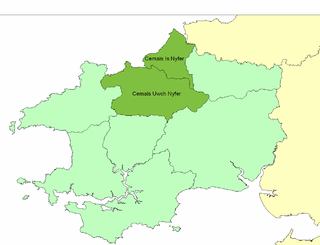
WCemais was an ancient cantref of the Kingdom of Dyfed, from the 11th century a Norman Marcher Lordship, from the 16th century a Hundred, and is now part of Pembrokeshire, Wales. It occupied the coastal area between the Teifi estuary and Fishguard, and the northern and southern slopes of the Preseli Hills, covering an area of approximately 140 square miles (360 km2). The Afon Nyfer divided it into two commotes: Cemais Is Nyfer to the north and Cemais Uwch Nyfer to the south.
 W
WChirkland was a marcher lordship in north-east Wales. It was created in 1282 from parts of Powys Fadog granted to Roger Mortimer de Chirk, third son of Roger Mortimer, 1st Baron Mortimer of Wigmore, who then built Chirk Castle from where the lordship was administered.
WCyfeiliog was a medieval commote in the cantref of Cynan of the Kingdom of Powys. Cynan also contained the commote of Mawddwy. Other sources refer to Cyfeiliog as a cantref in its own right, possibly as a result of Cynan being renamed for the largest commote within it.
 W
WDunoding was an early sub-kingdom within the Kingdom of Gwynedd in north-west Wales that existed between the 5th and 10th centuries. According to tradition, it was named after Dunod, a son of the founding father of Gwynedd - Cunedda Wledig - who drove the Irish settlers from the area in c.460. The territory existed as a subordinate realm within Gwynedd until the line of rulers descended from Dunod expired in c.925. Following the end of the House of Dunod, it was split into the cantrefi of Eifionydd and Ardudwy and fully incorporated into Gwynedd. After the defeat of the kingdom of Gwynedd in 1283 and its annexation to England, the two cantrefi became parts of the counties of Caernarfonshire and Meirionnydd respectively. It is now part of the modern county of Gwynedd within a devolved Wales.
 W
WElfael was one of a number of Welsh cantrefi occupying the region between the River Wye and river Severn, known as Rhwng Gwy a Hafren, in the early Middle Ages. It was divided into two commotes, Is Mynydd and Uwch Mynydd, separated by the chain of hills above Aberedw. In the late medieval period, it was a marcher lordship. However, after the Laws in Wales Act of 1535, it was one of the territorial units which went to make up the county of Radnorshire in 1536.
 W
WEmlyn was one of the seven cantrefi of Dyfed, an ancient district of Wales, which became part of Deheubarth in around 950. It consisted of the northern part of Dyfed bordering on the River Teifi. Its southern boundary followed the ridge of the line of hills separating the Teifi valley from the valleys of the Tâf and Tywi.
 W
WMaelienydd, sometimes spelt Maeliennydd, was a cantref and lordship in east central Wales covering the area from the River Teme to Radnor Forest and the area around Llandrindod Wells. The area, which is mainly upland, is now in Powys. During the Middle Ages it was part of the region known as Rhwng Gwy a Hafren and its administrative centre was at Cefnllys Castle.
WMechain was a medieval cantref in the Kingdom of Powys. This cantref has also been referred to as Y Fyrnwy (Vyrnwy). Mechain may owe its name to the River Cain which flows through it on its way to join the River Vyrnwy; 'Me' or 'Mach' may signify meadows or plain, in which case Mechain would mean "Meadows of the Cain". It corresponds to the later hundred of Llanfyllin.
 W
WMeirionnydd is a coastal and mountainous region of Wales. It has been a kingdom, a cantref, a district and, as Merionethshire, a county.
WMochnant, a name translating as "the rapid stream", was a medieval cantref in the Kingdom of Powys.
WPenllyn was a medieval cantref originally in the Kingdom of Powys but annexed to the Kingdom of Gwynedd. It consisted of the commotes of Edeyrnion, Dinmael, Penllyn is Treweryn and Penllyn uwch Treweryn.
WRhosyr was the name of one of the three medieval cantrefs on the island of Anglesey, north Wales, in the Kingdom of Gwynedd. It lay on the southern side of the island facing the Menai Strait which separates Anglesey from the mainland.
 W
WRhufoniog was a small sub-kingdom of the Dark Ages Gwynedd, and later a cantref in medieval Wales.
 W
WThe Hundred of Roose was a hundred in Pembrokeshire, Wales. It has its origins in the pre-Norman cantref of Rhos and was formalised as a hundred by the Laws in Wales Acts 1535–1542. Its area was about 102 square miles (260 km2). The area became an English "plantation" in the 12th century, part of the English-speaking Little England beyond Wales.
 W
WTegeingl, in English Englefield, was a cantref in north-east Wales during the mediaeval period. It was incorporated into Flintshire following Edward I of England's conquest of northern Wales in the 13th century.
WYstlyg was a medieval cantref in the Kingdom of Powys. It lay at the east of the kingdom on the border with England. It consisted of the commotes (cymydau) of Deuddwr in the north, Ystrad Marchell in the centre, Llannerch Hudol in the south, and Y Gorddwr in the east beyond the River Severn and Offa's Dyke.