 W
WThe Bat Creek inscription is an inscribed stone collected as part of a Native American burial mound excavation in Loudon County, Tennessee, in 1889 by the Smithsonian Bureau of Ethnology's Mound Survey, directed by entomologist Cyrus Thomas. The inscriptions were initially described as Cherokee, but in 2004, similarities to an inscription that was circulating in a Freemason book were discovered. Hoax expert Kenneth Feder says the peer reviewed work of Mary L. Kwas and Robert Mainfort has "demolished" any claims of the stone's authenticity. Mainfort and Kwas themselves state "The Bat Creek stone is a fraud."
 W
WThe Beasley Mounds Site (40SM43) is a Mississippian culture archaeological site located at the confluence of Dixon Creek and the Cumberland River near the unincorporated community of Dixon Springs in Smith County, Tennessee. The site was first excavated by amateur archaeologists in the 1890s. More examples of Mississippian stone statuary have been found at the site than any other in the Middle Tennessee area. The site was listed on the National Register of Historic Places in 2010.
WThe Brentwood Library Site (40WM210), also known as the Jarman Farm Site, is a Mississippian culture archaeological site located in the city of Brentwood, in Williamson County, Tennessee. It was occupied during Regional Period IV of the local Mississippian chronology, and artifacts from the site have been radiocarbon dated to between 1298 to 1465 CE.
 W
WThe Brick Church Mound and Village Site (40DV39) is a Mississippian culture archaeological site located in Nashville in Davidson County, Tennessee. It was excavated in the late nineteenth century by Frederic Ward Putnam. During excavations in the early 1970s the site produced a unique cache of ceramic figurines very similar in style to Mississippian stone statuary which are now on display at the Frank H. McClung Museum. It was added to the National Register of Historic Places (NRHP) on May 7, 1973 as NRIS number 73001759 although this did not save the site from being almost totally destroyed by residential development.
 W
WThe Castalian Springs Mound State Historic Site (40SU14) is a Mississippian culture archaeological site located near the small unincorporated community of Castalian Springs in Sumner County, Tennessee. The site was first excavated in the 1890s and again as recently as the 2005 to 2011 archaeological field school led by Dr. Kevin E. Smith. A number of important finds have been associated with the site, most particularly several examples of Mississippian stone statuary and the Castalian Springs shell gorget held by the National Museum of the American Indian. The site is owned by the State of Tennessee and is a State Historic Site managed by the Bledsoe's Lick Association for the Tennessee Historical Commission. The site is not currently open to the public.
 W
WChiaha was a Native American chiefdom located in the lower French Broad River valley in modern East Tennessee, in the southeastern United States. They lived in raised structures within boundaries of several stable villages. These overlooked the fields of maize, beans, squash, and tobacco, among other plants which they cultivated. Chiaha was the northern extreme of the paramount Coosa chiefdom's sphere of influence in the 16th century when the Spanish expeditions of Hernando de Soto and Juan Pardo passed through the area. The Chiaha chiefdom included parts of modern Jefferson and Sevier counties, and may have extended westward into Knox, Blount and Monroe counties.
 W
WChilhowee was a prehistoric and historic Native American site in Blount County and Monroe County, Tennessee, in the Southeastern Woodlands. Although now submerged by the Chilhowee Lake impoundment of the Little Tennessee River, the Chilhowee site was home to a substantial 18th-century Overhill Cherokee village and may have been the site of the Creek village "Chalahume" visited by Spanish explorer Juan Pardo in 1567.
WThe Denmark Mound Group or Denmark Site (40MD85) is a Mississippian culture archaeological site on a low bluff overlooking Big Black Creek, a tributary of the Hatchie River near Denmark in Madison County, Tennessee. The site features include a village with over 70 structures, 2 rectangular platform mounds and a small conical burial mound as well as possible evidence of a surrounding palisade. The site was added to the NRHP in 1992.
 W
WThe Eva site (40BN12) is a prehistoric Native American site in Benton County, Tennessee, in the Southeastern United States. Located along an ancient channel of the Tennessee River, the Eva site saw extensive periods of occupation during the Middle and Late Archaic period. The site's well-defined midden layers helped investigators identify three distinct Archaic cultures, the oldest of which was first identified at Eva and is still known as the "Eva culture" or the "Eva phase."
 W
WThe First American Cave is an archaeological and palentological site in downtown Nashville, Davidson County, Tennessee. The site was initially recorded in 1971 during construction of the foundations for the First American National Bank building at 315 Deaderick Street, when workers noticed a collection of bones being unearthed within a pocket of dirt approximately 30 feet below ground surface. Excavations were halted and both the Vanderbilt University Department of Anthropology and the Southeastern Indian Antiquities Survey were notified of the find. It was subsequently determined that the bones included those of humans, as well as a number of animal species, including a saber-tooth cat. The dirt pocket from which the bones had been disinterred was in fact a filled in cave, most of which had been destroyed by construction. The Southeastern Indian Antiquities Survey was given permission to excavate within the remaining portion of the cave with the assistance of Vanderbilt University students.
 W
WFort Pillow State Historic Park is a state park in western Tennessee that preserves the American Civil War site of the Battle of Fort Pillow. The 1,642 acre (6.6 km²) Fort Pillow, located in Lauderdale County on the Chickasaw Bluffs overlooking the Mississippi River, is rich in both historic and archaeological significance. In 1861, the Confederate army built extensive fortifications and named the site for General Gideon Johnson Pillow of Maury County. It was attacked and held by the Union Army for most of the American Civil War period except immediately after the Battle of Fort Pillow, when it was retaken by the Confederate Army. Many African-American soldiers were killed in what modern historians describe as a "massacre" or "atrocity". Interpretive sites are part of the park.
WThe Freel Farm Mound Site (40AN22) is an archaeological site and burial mound of the Woodland cultural period located on the Oak Ridge Reservation in Oak Ridge, Tennessee. The site was excavated in 1934 as part of the Norris Basin Survey by the Tennessee Valley Authority using labor from the Civil Works Administration under the supervision of T.M.N. Lewis. Important finds of the excavation include 17 burials and a few artifacts. The artifacts and records from the fieldwork are held by the McClung Museum in Knoxville, Tennessee.
WThe Freel Farm Mound Site (40AN22) is an archaeological site and burial mound of the Woodland cultural period located on the Oak Ridge Reservation in Oak Ridge, Tennessee. The site was excavated in 1934 as part of the Norris Basin Survey by the Tennessee Valley Authority using labor from the Civil Works Administration under the supervision of T.M.N. Lewis. Important finds of the excavation include 17 burials and a few artifacts. The artifacts and records from the fieldwork are held by the McClung Museum in Knoxville, Tennessee.
 W
WThe Island 35 Mastodon was discovered on Island No. 35 of the Mississippi River in Tipton County, Tennessee, United States.
WThe Link Farm State Archaeological Area, also known as the Duck River Temple Mounds or Duck River Site, is a Mississippian culture archaeological site located at the confluence of the Duck and Buffalo Rivers south of Waverly in Humphreys County, Tennessee. The site is most widely known for the stone artifacts found during excavations in the late 19th century.
 W
WThe McMahan Mound Site (40SV1), also known as McMahan Indian Mound, is an archaeological site located in Sevierville, Tennessee just above the confluence of the West Fork and the Little Pigeon Rivers in Sevier County.
 W
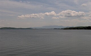
WMorganton was a community that developed on the Little Tennessee River in Loudon County, Tennessee, in the southeastern United States. It was located 13.7 miles (22.0 km) above the mouth of the river at its confluence with Bakers Creek, flowing westward from Maryville. During its heyday in the 19th century, Morganton thrived as a flatboat port and regional business center. An important ferry operated at Morganton for nearly 170 years providing service across the river. The abandoned townsite was submerged in the late 20th century by creation of Tellico Lake, part of the Tellico Dam hydroelectric project completed in 1979 by the Tennessee Valley Authority (TVA).
WObion Mounds, also known as the Work Farm Site, is an archaeological site of the Mississippian culture located north of Paris, Henry County, Tennessee, on the north fork of the Obion River. The site is the largest Mississippian site in western Tennessee and was probably inhabited by 1000 to 1100 CE. and abandoned by 1300. It consists of seven platform mounds surrounding a plaza measuring 200 feet (61 m) by 900 feet (270 m). The largest mound at the site was 500 feet (150 m) wide by 30 feet (9.1 m) tall with a ramp leading to its summit. At one point the mounds and plaza were surrounded with a wooden palisade. The site also has 2 depressions thought to be borrow pits from which the soil to construct the mounds was taken. In 1845 the owner of the site, Solomon Hartsfield, was digging in one of the borrow pits when he discovered a stone statue. The statue was later damaged in a house fire during the late 19th century and only its head now remains. It is the only Mississippian site in western Tennessee to have produced such a statue. Similar statues have been found at the Angel Mounds site near Evansville, Indiana and the Ware Mounds site in Union County, Illinois.
WThe Savannah Archaeological Site in Hardin County, Tennessee, is a prehistoric complex of platform mounds and village of the South Appalachian Mississippian culture, a regional variation of Mississippian culture.
WShiloh National Military Park preserves the American Civil War Shiloh and Corinth battlefields. The main section of the park is in the unincorporated town of Shiloh, about nine miles (14 km) south of Savannah, Tennessee, with an additional area located in the city of Corinth, Mississippi, 23 miles (37 km) southwest of Shiloh. The Battle of Shiloh began a six-month struggle for the key railroad junction at Corinth. Afterward, Union forces marched from Pittsburg Landing to take Corinth in a May siege, then withstood an October Confederate counter-attack.
 W
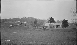
WThe Swaggerty Blockhouse is a historic structure near Parrottsville, in the U.S. state of Tennessee. The structure was originally believed to have been a frontier blockhouse built by early settler James Swaggerty in 1787. Recent archaeological evidence suggests, however, that the structure was actually a cantilever barn built by a farmer named Jacob Stephens around 1860.
WThe Swallow Bluff Island Mounds (40HR16) comprise a Mississippian culture archaeological site located near Saltillo on Swallow Bluff Island in the Tennessee River in Hardin County, Tennessee.
 W
WTallassee is a prehistoric and historic Native American site in Blount County and Monroe County, Tennessee, in the southeastern United States. Tallassee was the southernmost of a string of Overhill Cherokee villages that spanned the lower Little Tennessee River in the 18th century. Although it receives scant attention in primary historical accounts, Tallassee is one of the few Overhill towns to appear on every major 18th-century map of the Little Tennessee Valley.
 W
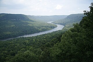
WThe Tennessee River Gorge is a 26-mile (42 km) canyon formed by the Tennessee River known locally as Cash Canyon. It is the fourth largest river gorge in the Eastern United States. The gorge is cut into the Cumberland Plateau as the river winds its way into Alabama from Tennessee. The Tennessee River Gorge is home to endangered species like the mountain skullcap. Many archaeological sites have been discovered in the gorge that show that people have been dwelling in the canyon for at least 10,000 years.
 W
WUBS Tower is a 108-meter (354-foot), 28-story skyscraper at 315 Deaderick Street in Nashville, Tennessee.