 W
WThe Alpha Hydraulic Diggings are located one mile north of what was the town of Alpha during the California Gold Rush in 1850, but the site is now near the unincorporated town of Washington, California. The diggings became a registered California Historical Landmark on January 29, 1958. The plaque's inscription reads: ALPHA AND OMEGA One mile north of here were the towns of Alpha and Omega, named by gold miners in the early 1850s. The tremendous hydraulic diggings, visible from near this point, engulfed most of the original townsites. Alpha was the birthplace of famed opera singer Emma Nevada. Mining at Omega continued until 1949, and lumbering operations are carried on there today (1958). California Registered Historical Landmarks Nos. 628-629
 W
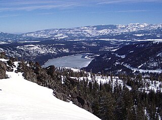
WDonner Memorial State Park is a state park of California, US, preserving the site of the Donner Camp, where members of the ill-fated Donner Party were trapped by weather during the winter of 1846–1847. Caught without shelter or adequate supplies, members of the group resorted to cannibalism to survive. The Sierra Nevada site has been designated a National Historic Landmark. The state park contains the Emigrant Trail Museum and the Pioneer Monument dedicated to the travelers of the Emigrant Trail.
 W
WThe Doris Foley Library for Historical Research is a reference and research library in Nevada City, in Nevada County, California. Built in 1907, the Romanesque Revival style building is currently a branch of the Nevada County Library System.
 W
WEmpire Mine State Historic Park is a state-protected mine and park in the Sierra Nevada mountains in Grass Valley, California, U.S. The Empire Mine is on the National Register of Historic Places, a federal Historic District, and a California Historical Landmark. Since 1975 California State Parks has administered and maintained the mine as a historic site. The Empire Mine is "one of the oldest, largest, deepest, longest and richest gold mines in California". Between 1850 and its closure in 1956, the Empire Mine produced 5.8 million ounces of gold, extracted from 367 miles (591 km) of underground passages.
WGold Hill, in Grass Valley, California, was the site of one of the first discoveries of quartz gold in California. While quartz gold was also found in other areas of Nevada County, California during the same time, it is this find near Wolf Creek that led to quartz-mining frenzy and subsequent creation of the Gold Country quartz-mining industry. The location is honored as a California Historical Landmark.
 W
WThe Home of Lola Montez is located in downtown Grass Valley, California at 248 Mill Street. Lola Montez, the internationally known singer and dancer, moved here in 1853, and this is the only home she ever owned.
WThe Home of Lotta Crabtree is located in downtown Grass Valley, California at 238 Mill Street.
 W
WThe Maidu are an American Indian people of northern California. They reside in the central Sierra Nevada, in the watershed area of the Feather and American rivers. They also reside in Humbug Valley. In Maiduan languages, Maidu means "man."
 W
WMartis is the name given by scientists to the group of Native Americans who lived in Northern California on both the eastern and western sides of the Sierra Nevada. The Martis complex lasted from 2000 BCE to 500 CE, during the Middle Archaic era. Evidence of Martis habitation has been found from Carson River and Reno, Nevada in the east to Auburn, California and Oroville, California in the west. The Martis name refers to the geographic region of Martis Creek which spans Nevada County, California and Placer County, California.
 W
WThe Nevada County Narrow Gauge Railroad (NCNGRR) was located in Northern California's Nevada County and Placer County, where it connected with the Central Pacific Railroad. The Nevada County Narrow Gauge Railroad Company incorporated on April 4, 1874, and was headquartered in Grass Valley, California. After two years of construction, passenger and commercial rail services began in 1876 and continued until 1943. The 22.53 mi (36.26 km) line ran from Colfax, north through Grass Valley to Nevada City. At one time, the railroad was notable for having the highest railroad bridge in California, the Bear River Bridge, built in 1908.
 W
WThe Nisenan are a group of Native Americans and an Indigenous people of California from the Yuba River and American River watersheds in Northern California and the California Central Valley. For generations, the Nisenan were mislabeled as Maidu, along with three other Tribes. The four Tribes are not Maidu Sub-groups. Nisenan is its own separate and unique culture, customs, leaders, holy people and language. The Nisenan language has 13 dialects.
 W
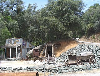
WThe North Bloomfield Mining and Gravel Company of North Bloomfield, California, was established in 1866 and operated a hydraulic gold-mining operation at the Malakoff Mine subsequent to the California Gold Rush. In its day, no other company's operations matched North Bloomfield Mining and Gravel Company in size or expense. The company operated until 1910. In the years prior, its profits and procedures had been reduced due to the landmark ruling of Woodruff v. North Bloomfield Gravel Mining Company.
WThe North Star Mine and Powerhouse are located on Lafayette Hill a short distance south of Grass Valley in the U.S. state of California. It was the second largest producer of gold during California's Gold Rush. In 1898, the largest ever Pelton wheel for its time was built for the mine. The North Star Mine Company also owned locations on Weimar Hill, adjoining and south of the North Star Mine. It shut down during World War II after its consolidation with the Empire Mine.
WThe Omega Hydraulic Diggings are located 1 mile (1.6 km) north of what was the town of Omega, California during the California Gold Rush. The site is southeast of the unincorporated town of Washington, California. From SR 20, the diggings are reachable via the gravel Omega Road which merges with Forest Route 29 in small sections.
 W
WRough and Ready is a census-designated place in Nevada County, California, United States. It is located west of Grass Valley, California, approximately 62 miles (100 km) from Sacramento. The population was 963 at the 2010 census. It has frequently been noted on lists of unusual place names.
 W
WThe Wintun are members of several related Native American peoples of Northern California, including the Wintu (northern), Nomlaki (central), and Patwin (southern). Their range is from approximately present-day Lake Shasta to San Francisco Bay, along the western side of the Sacramento River to the Coast Range. Each of these tribes speak one of the Wintuan languages. Linguistic and archaeological evidence suggests that the Wintun people probably entered the California area around 500 AD from what is now southern Oregon, introducing bow and arrow technology to the region.
 W
WThe case of Woodruff v. North Bloomfield Gravel Mining Company was a lawsuit brought to California courts in 1882 where a group of local farmers sued North Bloomfield Mining and Gravel Company over damages caused to farmland in the Central Valley. The farmers who brought the suit claimed that the company's hydraulic mining operations resulted in the disposal of excess sediment, debris, and chemicals in local rivers. Prosecutors argued that the debris raised river beds and restricted flow in the rivers leading to heavy man-made flooding. In the years prior, flooding of debris and chemicals had destroyed a large portion of the valley's agriculture.
WYou Bet is a small unincorporated community in Nevada County, California. You Bet is located in the Sierra Nevada foothills, 7 miles (11.3 km) east of Grass Valley and 5.5 miles (8.9 km) northeast of Chicago Park.