 W
WThe following timeline traces the territorial evolution of the U.S. State of Idaho.
 W
WThe Territory of Idaho was an organized incorporated territory of the United States that existed from March 3, 1863, until July 3, 1890, when the final extent of the territory was admitted to the Union as Idaho.
 W
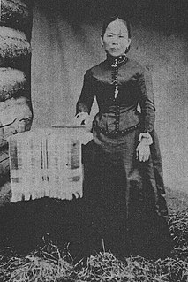
WPolly Bemis was a Chinese American pioneer who lived in Idaho in the late 19th and early 20th century. Her story became a biographical novel, and was the subject of the 1991 film Thousand Pieces of Gold.
 W
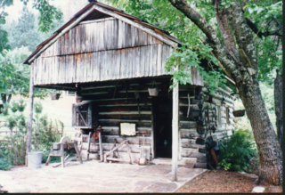
WPolly Bemis House was the home of pioneers to Idaho County, Idaho, USA, Charles Bemis and his wife Polly Bemis, who lived alongside the Salmon River in the late 19th and early 20th century. Polly was a Chinese American former teenage slave whose story became a biographical novel and was fictionalized in the 1991 film A Thousand Pieces of Gold.
 W
WPatrick Edward Connor was a Union general during the American Civil War. He is most notorious for his campaigns against Native Americans during the Indian Wars in the American Old West.
 W
WFort Boise is either of two different locations in the western United States, both in southwestern Idaho. The first was a Hudson's Bay Company (HBC) trading post near the Snake River on what is now the Oregon border, dating from the era when Idaho was included in the British fur company's Columbia District. After several rebuilds, the fort was ultimately abandoned in 1854, after it had become part of United States territory following settlement in 1846 of the northern boundary dispute.
 W
WFort Hall was a fort that was built in 1834 as a fur trading post by Nathaniel Jarvis Wyeth. It was located on the Snake River in the eastern Oregon Country, now part of present-day Bannock County in southeastern Idaho, United States. Mr. Wyeth was an inventor and businessman from Boston, Massachusetts, who also founded a post at Fort William, in present-day Portland, Oregon, as part of a plan for a new trading and fisheries company. Unable to compete with the powerful British Hudson's Bay Company, based at Fort Vancouver, in 1837 Wyeth sold both posts to it. Great Britain and the United States both operated in the Oregon Country in these years.
 W
WThe Fort Hall Reservation is a Native American reservation of the federally recognized Shoshone-Bannock Tribes in the U.S. state of Idaho. This is one of five federally recognized tribes in the state. The reservation is located in southeastern Idaho on the Snake River Plain about 20 miles (32 km) north and west of Pocatello. It comprises 814.874 sq mi (2,110.51 km2) of land area in four counties: Bingham, Power, Bannock, and Caribou. To the east is the 60-mile-long (97 km) Portneuf Range; both Mount Putnam and South Putnam Mountain are located on the Fort Hall Reservation.
 W
WThe Territory of Missouri was an organized incorporated territory of the United States that existed from June 4, 1812 until August 10, 1821. In 1819, the Territory of Arkansas was created from a portion of its southern area. In 1821, a southeastern portion of the territory was admitted to the Union as the State of Missouri, and the rest became unorganized territory for several years.
 W
WThe Oregon boundary dispute or the Oregon Question was a 19th-century territorial dispute over the political division of the Pacific Northwest of North America between several nations that had competing territorial and commercial aspirations over the region.
 W
WThe Pacific Fur Company (PFC) was an American fur trade venture wholly owned and funded by John Jacob Astor that functioned from 1810 to 1813. It was based in the Pacific Northwest, an area contested over the decades between the United Kingdom of Great Britain and Ireland, the Spanish Empire, the United States of America and the Russian Empire.
 W
WPierre's Hole is a shallow valley in the western United States in eastern Idaho, just west of the Teton Range in Wyoming. At an elevation over 6,000 feet (1,830 m) above sea level, it collects the headwaters of the Teton River, and was a strategic center of the fur trade of the northern Rocky Mountains. The nearby Jackson's Hole area in Wyoming is on the opposite side of the Tetons.
 W
WRattlesnake Station was a stagecoach station northeast of Mountain Home, Idaho, and the original site of the Mountain Home post office. Approximately seven miles from exit 95 on Interstate 84 in present-day Elmore County, a historical marker located at milepost 102.7 on U.S. Route 20 commemorates its location. The highway follows Rattlesnake Creek and the elevation of the site at the base of the grade is 3,820 feet (1,164 m) above sea level.
 W
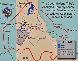
WThe Coeur d'Alene War of 1858, also known as the Spokane-Coeur d'Alene-Pend d'oreille-Paloos War, was the second phase of the Yakima War, involving a series of encounters between the allied Native American tribes of the Skitswish, Kalispell, Spokane, Palouse and Northern Paiute against United States Army forces in Washington and Idaho.
 W
WThe Treaty of Hellgate was signed in Hellgate on July 16, 1855 between Indian commissioner Isaac Stevens and the Native American tribes located in western Montana. The treaty was ratified by Congress, signed by President James Buchanan, and proclaimed on April 18, 1859.
 W
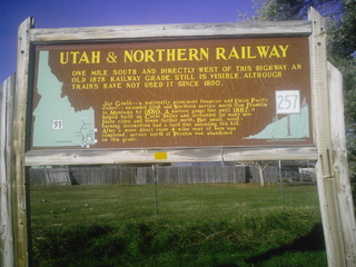
WThe Utah & Northern Railway is a defunct railroad that was operated in the Utah Territory and later in the Idaho Territory and Montana Territory in the western United States during the 1870s and 1880s. It was the first railroad in Idaho and in Montana.
 W
WWeippe Prairie is a "beautiful upland prairie field of about nine by twenty miles of open farmland bordered by pine forests" at 3,000 feet elevation in Clearwater County, Idaho, at Weippe, Idaho. Camas flowers grow well there, and attracted native gatherers of the camas roots. It is the location in Idaho where the Lewis and Clark Expedition emerged from crossing the Bitterroot Mountains on the Lolo Trail and first met the Nez Perce tribe of Native Americans.