 W
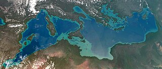
WAtlantropa, also referred to as Panropa, was a gigantic engineering and colonisation idea that was devised by the German architect Herman Sörgel in the 1920s and promoted by him until his death, in 1952. Its central feature was a hydroelectric dam to be built across the Strait of Gibraltar, which would have provided enormous amounts of hydroelectricity and would have led to the lowering of the surface of the Mediterranean Sea by up to 200 metres (660 ft), opening up large new lands for settlement, such as in the Adriatic Sea. The project proposed four additional major dams as well:Across the Dardanelles to hold back the Black Sea Between Sicily and Tunisia to provide a roadway and lower the inner Mediterranean further On the Congo River below its Kwah River tributary to refill the Mega-Chad basin around Lake Chad to provide fresh water to irrigate the Sahara and create a shipping lane to the interior of Africa Suez Canal extension and locks to maintain a Red Sea connection
 W
WThe Danube–Black Sea Canal is a navigable canal in Romania, which runs from Cernavodă on the Danube river, via two branches, to Constanța and Năvodari on the Black Sea. Administrated from Agigea, it is an important part of the waterway link between the North Sea and the Black Sea via the Rhine–Main–Danube Canal. The main branch of the canal, with a length of 64.4 km (40.0 mi), which connects the Port of Cernavodă with the Port of Constanța, was built in two periods, 1949–1953 and 1973–1984, while the northern branch, known as the Poarta Albă–Midia Năvodari Canal, with a length of 31.2 km (19.4 mi), connecting Poarta Albă and the Port of Midia, was built between 1983 and 1987.
 W
WThe Istanbul Canal is a project for the artificial sea-level waterway, which is planned by Turkey on East Thrace, connecting the Black Sea to the Sea of Marmara, and thus to the Aegean and Mediterranean seas. Istanbul Canal would bisect the current European side of Istanbul and thus form an island between Asia and Europe. The new waterway would bypass the current Bosporus.
 W
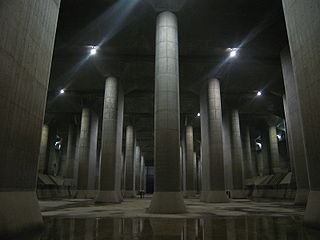
WThe Metropolitan Area Outer Underground Discharge Channel , is an underground water infrastructure project in Kasukabe, Saitama, Japan. It is the world's largest underground flood water diversion facility, built to mitigate overflowing of the city's major waterways and rivers during rain and typhoon seasons. It is located between Showa in Tokyo and Kasukabe in Saitama prefecture, on the outskirts of the city of Tokyo in the Greater Tokyo Area, Japan.
 W
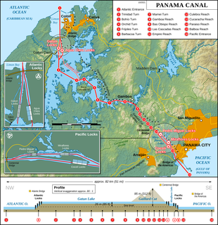
WThe Panama Canal is an artificial 82 km (51 mi) waterway in Panama that connects the Atlantic Ocean with the Pacific Ocean. The canal cuts across the Isthmus of Panama and is a conduit for maritime trade. One of the largest and most difficult engineering projects ever undertaken, the Panama Canal shortcut greatly reduces the time for ships to travel between the Atlantic and Pacific oceans, enabling them to avoid the lengthy, hazardous Cape Horn route around the southernmost tip of South America via the Drake Passage or Strait of Magellan and the even less popular route through the Arctic Archipelago and the Bering Strait.
 W
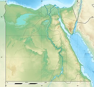
WThe Qattara Depression Project, or Qattara Project for short, is a macro-engineering project concept in Egypt. Rivalling the Aswan High Dam in scope, the intention is to develop the hydroelectric potential of the Qattara Depression by creating an artificial lake.
 W
WThe Red River Floodway is an artificial flood control waterway in Western Canada. It is a 47 km (29 mi) long channel which, during flood periods, takes part of the Red River's flow around the city of Winnipeg, Manitoba to the east and discharges it back into the Red River below the dam at Lockport. It can carry floodwater at a rate of up to 140,000 cubic feet per second (4,000 m3/s), expanded in the 2000s from its original channel capacity of 90,000 cubic feet per second (2,500 m3/s).
 W
WThe Red Sea dam is a speculative macro-engineering proposal put forward in 2007 by a group of scientists and engineers. Although the authors' intentions are to explore "the ethical and environmental dilemmas and some of the political implications of macro-engineering", the proposal has attracted both criticism and ridicule.
 W
WThe Sahara Sea was the name of a hypothetical macro-engineering project which proposed flooding endorheic basins in the Sahara Desert with waters from the Atlantic Ocean or Mediterranean Sea. The goal of this unrealized project was to create an inland sea that would cover the substantial areas of the Sahara Desert which lie below sea level, bringing humid air, rain, and agriculture deep into the desert.
 W
WSethusamudram Shipping Canal Project is a proposed project to create a shipping route in the shallow straits between India and Sri Lanka. This would provide a continuously navigable sea route around the Indian Peninsula. The channel would be dredged in the Sethusamudram sea between Tamil Nadu and Sri Lanka, passing through the limestone shoals of Rama's Bridge.
 W
WThe South–North Water Transfer Project, also translated as the South-to-North Water Diversion Project is a multi-decade infrastructure mega-project in China. Ultimately it aims to channel 44.8 billion cubic meters of fresh water annually from the Yangtze River in southern China to the more arid and industrialized north through three canal systems:The Eastern Route through the course of the Grand Canal; The Central Route from the upper reaches of Han River via the Grand Aqueduct to Beijing and Tianjin; The Western Route which goes from three tributaries of Yangtze River near the Bayankala Mountain to provinces like Qinghai, Gansu, Shaanxi, Shanxi, Inner Mongolia and Ningxia.
 W
WThe Suez Canal is an artificial sea-level waterway in Egypt, connecting the Mediterranean Sea to the Red Sea through the Isthmus of Suez. It is often considered to define the border between Africa and Asia. Constructed by the Suez Canal Company between 1859 and 1869, it officially opened on 17 November that year. The canal offers watercraft a more direct route between the North Atlantic and northern Indian oceans via the Mediterranean and Red seas, thus avoiding the South Atlantic and southern Indian oceans and reducing the journey distance from the Arabian Sea to London, for example, by approximately 8,900 kilometres (5,500 mi). It extends from the northern terminus of Port Said to the southern terminus of Port Tewfik at the city of Suez. Its length is 193.30 km (120.11 mi) including its northern and southern access-channels. In 2012, 17,225 vessels traversed the canal.