 W
WAssisi is a town and comune of Italy in the Province of Perugia in the Umbria region, on the western flank of Monte Subasio.
 W
WBastia Umbra is a comune (municipality) in the Province of Perugia in the Italian region Umbria, located about 15 km southeast of Perugia. As of 31 December 2004, it had a population of 20,523 and an area of 27.6 km².
 W
WBettona is an ancient town and comune of Italy, in the province of Perugia in central Umbria at the northern edge of the Colli Martani range. It is 5 km (3 mi) E of Torgiano and 12 km (7 mi) SW of Assisi.
 W
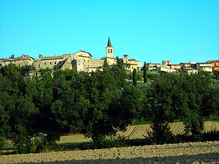
WBevagna is a town and comune in the central part of the Italian province of Perugia (Umbria), in the flood plain of the Topino river.
 W
WCampello sul Clitunno is a comune (municipality) in the Province of Perugia in the Italian region Umbria, about 45 km southeast of Perugia.
 W
WCannara is a town and comune on the Topino River in the floodplain of central Umbria, in the province of Perugia. It is located about 7 km west of Spello and 9 km north of Bevagna.
 W
WCascia is a town and comune (municipality) of the Italian province of Perugia in a rather remote area of the mountainous southeastern corner of Umbria. It is about 21 km from Norcia on the road to Rieti in the Lazio (63 km). It is also very close to Terni.
 W
WCastel Ritaldi is a comune (municipality) in the Province of Perugia in the Italian region Umbria, located about 40 km southeast of Perugia.
 W
WCastiglione del Lago is a town in the province of Perugia of Umbria, on the southwest corner of Lake Trasimeno. Orvieto is 59 km (37 mi) south, Chiusi is 21 km (13 mi) to the south west, Arezzo is 56 km (35 mi) to the north west, Cortona is 21 km (13 mi) to the north and Perugia is 47 km (29 mi) to the south east.
 W
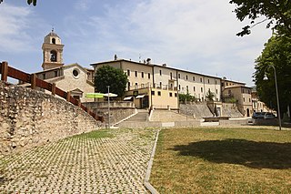
WCerreto di Spoleto is an Italian village and comune of the province of Perugia in Umbria. It is a dispersed rural community with 1,158 inhabitants spread over 8 frazioni. Its claim to fame is to be the root of the English term "charlatan", as Cerreto was once widely known for the quacks among its natives.
 W
WCiterna is a comune (municipality) in the Province of Perugia in the Italian region Umbria, located about 50 km northwest of Perugia.
 W
WCittà della Pieve is a comune (municipality) in the Province of Perugia in the Italian region Umbria, located in Valdichiana a few kilometres from the border between Umbria and Tuscany, and about 50 km (31 mi) southwest of Perugia and 11 km (7 mi) southeast of Chiusi in Tuscany.
 W
WCittà di Castello ; "Castle Town") is a city and comune in the province of Perugia, in the northern part of Umbria. It is situated on a slope of the Apennines, on the flood plain along the upper part of the river Tiber. The city is 56 km (35 mi) north of Perugia and 104 km (65 mi) south of Cesena on the motorway SS 3 bis. It is connected by the SS 73 with Arezzo and the A1 highway, situated 38 km (23 mi) west. The comune of Città di Castello has an exclave named Monte Ruperto within Marche.
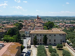
WCollazzone is a comune (municipality) in the Province of Perugia in the Italian region Umbria, located about 25 km south of Perugia. As of 31 December 2004, it had a population of 3,108 and an area of 55.8 km².
 W
WCorciano is a comune (municipality) in the Province of Perugia in the Italian region Umbria, located about 8 km west of Perugia. As of 31 December 2004, it had a population of 17,008 and an area of 63.7 km². Corciano borders the comuni of Magione and Perugia.
 W
WCostacciaro is a comune (municipality) in the Province of Perugia in the Italian region Umbria, located about 40 km northeast of Perugia. It is a medieval burgh, which, after the rule of Perugia and Gubbio, became part of the Papal States in the 15th century.
 W
WDeruta is a hill town and comune in the Province of Perugia in the Umbria region of central Italy. Long known as a center of refined maiolica manufacture, Deruta remains known for its ceramics, which are exported worldwide.
 W
WFoligno is an ancient town of Italy in the province of Perugia in east central Umbria, on the Topino river where it leaves the Apennines and enters the wide plain of the Clitunno river system. It is located 40 kilometres south-east of Perugia, 10 km (6 mi) north-north-west of Trevi and 6 km (4 mi) south of Spello.
 W
WFossato di Vico is a town and comune of Umbria in the province of Perugia in Italy, at 581 m above sea‑level on the middle slopes of Mount Mutali.
 W
WFratta Todina is a comune in the Province of Perugia in the Italian region Umbria, located about 30 km south of Perugia.
 W
WGiano dell'Umbria is a comune (municipality) in the Province of Perugia in the Italian region Umbria, located about 35 km southeast of Perugia.
 W
WGualdo Cattaneo is a comune (municipality) in the Province of Perugia in the Italian region Umbria, located about 25 km southeast of Perugia.
WGualdo Tadino is an ancient town of Italy, in the province of Perugia in northeastern Umbria, on the lower flanks of Monte Penna, a mountain of the Apennines. It is 47 kilometres (29 mi) NE of Perugia.
 W
WGubbio is a town and comune in the far northeastern part of the Italian province of Perugia (Umbria). It is located on the lowest slope of Mt. Ingino, a small mountain of the Apennines.
WLisciano Niccone is a comune (municipality) in the Province of Perugia in the Italian region Umbria, located about 25 km northwest of Perugia.
 W
WMagione is a comune (municipality) in the Province of Perugia in the Italian region Umbria, located about 15 km west of Perugia.
 W
WMarsciano is a comune (municipality) in the Province of Perugia in the Italian region Umbria, located about 25 km south of Perugia.
 W
WMassa Martana is an ancient Italian town and comune in the Monti Martani mountain range in the province of Perugia (Umbria). It is 10 km N of Acquasparta, 18 km N of San Gemini and 32 km N of Narni; 14 km S of Bastardo and 27 km S of Bevagna. As of the 2003 census, the town had 3558 inhabitants.
 W
WMonte Castello di Vibio is a comune (municipality) in the Province of Perugia in the Italian region Umbria, located about 30 km south of Perugia. Monte Castello di Vibio borders the following municipalities: Fratta Todina, San Venanzo, Todi.
 W
WMonte Santa Maria Tiberina is a comune (municipality) in the province of Perugia in the Italian region Umbria, located about 40 km northwest of Perugia.
 W
WMontefalco
 W
WMonteleone di Spoleto, is a town and comune of Italy, in the province of Perugia in southeast Umbria at 978 meters (3209 ft) above sea-level overhanging the upper valley of the Corno River. It is one of the more remote towns in Umbria, on a mountain road from Norcia and Cascia to Leonessa and Rieti in the Lazio.
 W
WMontone is a comune (municipality) in the Province of Perugia in the Italian region Umbria, located about 35 km north of Perugia.
 W
WNocera Umbra is a town and comune in the province of Perugia, Italy, 15 kilometers north of Foligno, at an altitude of 520 m above sea-level. The comune, covering an area of 157.19 km², is one of the largest in Umbria.
WNorcia, traditionally known in English by its Latin name of Nursia, is a town and comune in the province of Perugia (Italy) in southeastern Umbria. Unlike many ancient towns, it is located in a wide plain abutting the Monti Sibillini, a subrange of the Apennines with some of its highest peaks, near the Sordo River, a small stream that eventually flows into the Nera. The town is popularly associated with the Valnerina.
 W
WPaciano is a comune (municipality) in the Province of Perugia in the Italian region Umbria, located about 30 km southwest of Perugia. As of 31 December 2004, it had a population of 974 and an area of 16.8 km².
 W
WPanicale is a comune (municipality) in the Province of Perugia in the Italian region Umbria. Located on the eastern slope of Mount Petrarvella, in the southeast of Valdichiana, it overlooks Lake Trasimeno and it is about 35 km far from Perugia.
 W
WPassignano sul Trasimeno is a comune (municipality) in the Province of Perugia in the Italian region of Umbria, located about 20 km northwest of Perugia.
WPerugia is the capital city of Umbria in central Italy, crossed by the River Tiber, and of the province of Perugia. The city is located about 164 km (102 mi) north of Rome and 148 km (92 mi) southeast of Florence. It covers a high hilltop and part of the valleys around the area. The region of Umbria is bordered by Tuscany, Lazio, and Marche.
WPiegaro is a comune (municipality) in the Province of Perugia in the Italian region Umbria, located about 30 km southwest of Perugia. Piegaro borders the following municipalities: Città della Pieve, Marsciano, Montegabbione, Monteleone d'Orvieto, Paciano, Panicale, Perugia, San Venanzo.
 W
WPietralunga is a comune (municipality) in the Province of Perugia in the Italian region Umbria, located about 35 km (22 mi) north of Perugia. As of 31 December 2004, it had a population of 2,343 and an area of 140.2 km².
 W
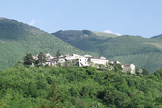
WPoggiodomo is a comune (municipality) in the Province of Perugia in the Italian region Umbria, located about 80 km southeast of Perugia.
 W
WPreci is a comune (municipality) in the Province of Perugia in the Italian region Umbria, located about 60 km southeast of Perugia.
 W
WSan Giustino is a comune (municipality) in the Province of Perugia in the Italian region Umbria, located about 50 kilometres northwest of Perugia on the Tiber River.
 W
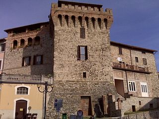
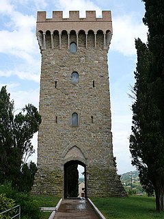
WSant'Anatolia di Narco is a comune (municipality) in the Province of Perugia in the Italian region Umbria, located about 60 km southeast of Perugia, in the middle Valnerina valley. It is a medieval town commanded by a 12th-century castle, with a 14th-century line of walls.
 W
WScheggia e Pascelupo is a comune (municipality) in the Province of Perugia in the Italian region Umbria, located about 40 km northeast of Perugia. The municipal seat is located in the main village of Scheggia, just below Scheggia Pass on Route SS/SR 3 Flaminia, following the ancient Via Flaminia.
 W
WScheggino is a comune (municipality) in the Province of Perugia in the Italian region Umbria, located about 60 km southeast of Perugia. As of January 2020, it had a population of 464 and an area of 35.2 km².
 W
WSellano is a comune (municipality) in the Province of Perugia in the Italian region Umbria, located about 50 km southeast of Perugia. As of 31 December 2018, it had a population of 1,048 and an area of 85.7 km².
 W
WSigillo is a comune (municipality) in the province of Perugia in the Italian region Umbria, located about 35 km northeast of Perugia.
 W
WSpello is an ancient town and comune (township) of Italy, in the province of Perugia in east central Umbria, on the lower southern flank of Mt. Subasio. It is 6 km (4 mi) NNW of Foligno and 10 km (6 mi) SSE of Assisi.
 W
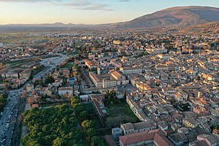
WSpoleto is an ancient city in the Italian province of Perugia in east-central Umbria on a foothill of the Apennines. It is 20 km (12 mi) S. of Trevi, 29 km (18 mi) N. of Terni, 63 km (39 mi) SE of Perugia; 212 km (132 mi) SE of Florence; and 126 km (78 mi) N of Rome.
 W
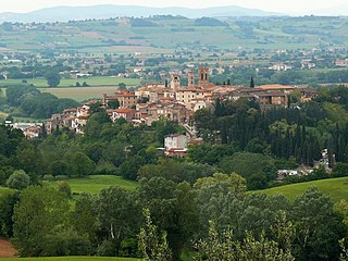
WTodi is a town and comune (municipality) of the province of Perugia in central Italy. It is perched on a tall two-crested hill overlooking the east bank of the river Tiber, commanding distant views in every direction.
 W
WTorgiano is a comune (municipality) in the Province of Perugia in the Italian region Umbria, located about 10 km southeast of Perugia.
 W
WTrevi is an ancient town and comune in Umbria, Italy, on the lower flank of Monte Serano overlooking the wide plain of the Clitunno river system. It is 10 km (6 mi) SSE of Foligno and 20 km (12 mi) north of Spoleto.
 W
WTuoro sul Trasimeno is a comune (municipality) in the province of Perugia in the Italian region Umbria, located about 25 km northwest of Perugia.
WUmbertide is a town and comune (township) of Italy, in the province of Perugia and in northwestern Umbria, at the confluence of the Reggia river and the Tiber. It is 30 km (19 mi) North of Perugia and 20 km (12 mi) South of Città di Castello. With 16,607 inhabitants according to the 2017 census, Umbertide is one of the larger towns of Umbria; and basically flat. It is an industrial center producing machine tools, textiles, packaging material, and ceramics. Olive oil is produced, especially in Pierantonio and in its southwestern part.
 W
WValfabbrica is a comune (municipality) in the Province of Perugia in the Italian region Umbria, located about 20 km northeast of Perugia. As of 31 December 2004, it had a population of 3,542 and an area of 92.1 km2 (35.6 sq mi).
 W
WVallo di Nera is a comune (municipality) in the Province of Perugia in the Italian region Umbria, located about 60 km southeast of Perugia.
WValtopina is a comune (municipality) in the Province of Perugia in the Italian region Umbria, located about 30 km east of Perugia. As of 31 December 2004, it had a population of 1,399 and an area of 40.5 km².