 W
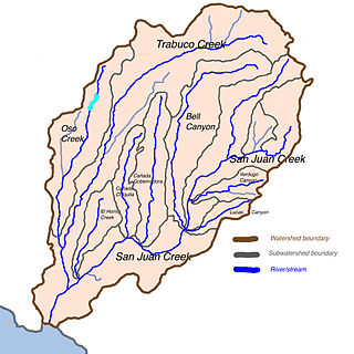
WSan Juan Creek, also called the San Juan River, is a 29-mile (47 km) long stream in Orange County, California, draining a watershed of 133.9 square miles (347 km2). Its mainstem begins in the southern Santa Ana Mountains in the Cleveland National Forest. It winds west and south through San Juan Canyon, and is joined by Arroyo Trabuco as it passes through San Juan Capistrano. It flows into the Pacific Ocean at Doheny State Beach. San Juan Canyon provides a major part of the route for California State Route 74.
 W
WArroyo Trabuco is a 22-mile (35 km)-long stream in coastal southern California in the United States. Rising in a rugged canyon in the Santa Ana Mountains of Orange County, the creek flows west and southwest before emptying into San Juan Creek in the city of San Juan Capistrano. Arroyo Trabuco's watershed drains 54 square miles (140 km2) of hilly, semi-arid land and lies mostly in Orange County, with a small portion extending northward into Riverside County. The lower section of the creek flows through three incorporated cities and is moderately polluted by urban and agricultural runoff.
 W
WBell Canyon is a major drainage of the Santa Ana Mountains in Orange County, California in the United States. Bell Creek flows about 14.4 miles (23.2 km) in a southerly direction to its confluence with San Juan Creek. The Bell Canyon drainage is located to the east and parallel to Cañada Gobernadora, and to the south of Trabuco Creek. After Trabuco Creek, it is the second largest tributary of San Juan Creek in terms of length and its watershed area of 26 square miles (67 km2).
 W
WCañada Gobernadora is a tributary to San Juan Creek, about 8.5 miles (13.7 km) long, in southern Orange County in the U.S. state of California. The creek begins in the foothills of the Santa Ana Mountains, at an elevation of 1,040 feet (320 m), and flows south through residential, agricultural and finally undeveloped land, to its confluence with San Juan Creek a few miles upstream of the city of San Juan Capistrano. The upper half of the stream is largely channelized and flows through golf courses, while the lower half is a wash-like channel that can be up to 700 feet (210 m) wide. The stream receives some urban runoff from the residential communities higher in its watershed. The watershed includes several geologic formations, including the Tertiary Sespe Formation and Santiago Formation, and Holocene sedimentary and alluvial deposits embedded in its narrow floodplain. Cañada Gobernadora forms an unofficial dividing line for the lower portion of the San Juan watershed; most urban development is confined to west of the creek's valley, while agricultural and undeveloped lands lie to the east of the creek.
 W
WSan Juan Creek is a creek in Orange County in the U.S. state of California. It is about 29 miles (47 km) long, and along with its major tributary, Trabuco Creek, drains 133 square miles (340 km2) near the southernmost extent of Orange County. This article describes the course of San Juan Creek.
WEl Horno Creek or Horno Creek is a tributary stream of San Juan Creek in Orange County in the U.S. state of California. It is approximately 5.9 miles (9.5 km) long and drains an area of 4.3 square miles (11 km2). The creek joins San Juan Creek on the right bank, only a few hundred yards upstream of the Trabuco Creek confluence, within the city limits of San Juan Capistrano.
 W
WMorrell Canyon Creek is a stream or Arroyo, tributary to San Juan Creek, located in the Cleveland National Forest in Riverside County, California, at an elevation of 3,080 ft (939 m), in the Elsinore Mountains northeast of Elsinore Peak. It arises on the eastern slope of San Mateo Peak. An eastern fork draining the Morrell Potrero joins it a little over a mile north of its source and then flows northwestward about a third of a mile where it turns southeast descending the narrow Morrell Canyon east of Lion Spring. After descending 2.5 miles it turns north for half a mile then returns to a southwestern direction for another mile, the canyon widening here until it turns northwestward and down a steep canyon again for half a mile where it takes in from the right Decker Canyon Creek and Long Canyon Creek. It then turns southwestward again into a wider canyon and descends to its confluence with Bear Canyon Creek and becomes the head of San Juan Creek.
 W
WOso Creek is an approximately 13.5-mile (21.7 km) tributary of Arroyo Trabuco in southern Orange County in the U.S. state of California. Draining about 20 square miles (52 km2) in a region north of the San Joaquin Hills and south of the Santa Ana Mountains, the creek is Trabuco Creek's largest tributary, and is part of the San Juan Creek drainage basin. Beginning in the foothills of the Santa Ana Mountains near the city of Mission Viejo, the creek is dammed twice to form Upper Oso Reservoir and Lake Mission Viejo. The creek is channelized and polluted along much of its length.
WTrampas Canyon is a short tributary of San Juan Creek in southern Orange County the U.S. state of California. It rises in forks on steep slopes of the southern Santa Ana Mountains, and flows north to where it is dammed by Trampas Canyon Dam. Trampas Canyon 1795-006 Dam (33.498359°N 117.587548°W) forms a small lake that branches into four forks running east–west. Exiting the dam, the creek flows north and turns slightly to the west, where it joins San Juan Creek on the left bank, near the confluence of Cañada Gobernadora. Trampas Canyon Creek is ephemeral and only flows during storm events or while Trampas Canyon Dam is releasing, and is not a primary tributary of San Juan Creek.