 W
WThe Manti–La Sal National Forest covers more than 1.2 million acres (4,900 km2) and is located in the central and southeastern parts of the U.S. state of Utah and the extreme western part of Colorado. The forest is headquartered in Price, with ranger district offices in Price, Ferron, Ephraim, Moab and Monticello. The maximum elevation is Mount Peale in the La Sal Mountains, reaching 12,721 feet (3,877 m) above sea level. The La Sal Mountains are the second highest mountain range in Utah after the Uintas. Parts of the forest are included in the Bears Ears National Monument.
 W
WThe Abajo Mountains, sometimes referred to as the Blue Mountains, is a small mountain range west of Monticello, Utah, south of Canyonlands National Park and north of Blanding, Utah. The mountain range is located within the Manti–La Sal National Forest. The highest point within the range is Abajo Peak at 11,360 feet (3,463 m).
 W
WDark Canyon Wilderness is a designated Wilderness Area in the heart of southeast Utah's canyon country, part of the Bears Ears National Monument. The wilderness is named for its high steep walls that narrow in the lower section so that they block the light in the morning and late afternoon. The roughly horseshoe-shaped wilderness is made up of the upper part of 40-mile-long (64 km) Dark Canyon and two major tributaries, Woodenshoe Canyon and Peavine Canyon in the Manti-La Sal National Forest. These canyons all descend from pine-covered Elk Ridge northeast of Natural Bridges National Monument. Dark Canyon continues west within a U.S. Bureau of Land Management primitive area that is recommended for wilderness designation. The last four miles (6.4 km) of the main canyon drop steeply through Glen Canyon National Recreation Area into Lake Powell.
WThe La Sal Mountains or La Sal Range are a mountain range located in Grand and San Juan counties, Utah along the Utah/Colorado border. The range rises above and southeast of Moab and north of the town of La Sal. This range is part of the Manti-La Sal National Forest and the southern Rocky Mountains. The maximum elevation is at Mount Peale, reaching 12,721 feet (3,877 m) above sea level. The range contains three clusters of peaks separated by passes. The peaks span a distance of about 10 miles (16 km). The name of the range dates to Spanish times, when the Sierra La Sal were a prominent landmark on the Old Spanish Trail between Santa Fe and Los Angeles.
 W
WMount Mellenthin is a 12,645-foot elevation summit located in San Juan County of Utah, United States. Mount Mellenthin is the second-highest peak of the La Sal Mountains. It is situated in a dry, rugged, sparsely settled region, and set on land administered by Manti-La Sal National Forest. Precipitation runoff from this mountain drains into tributaries of the Colorado River. The nearest town is Moab, 20 mi (32 km) to the northwest, and the nearest higher neighbor is Mount Peale, 1.7 mi (2.7 km) to the south. The mountain's name honors Rudolf E. Mellenthin (1884–1918), forest ranger of La Sal National Forest, who was shot to death near this peak on August 23, 1918, while attempting to apprehend two draft evaders. This geographical feature's name was officially adopted in 1932 by the U.S. Board on Geographic Names.
 W
WMount Peale is the highest point in the La Sal Mountains of San Juan County, in the southeastern part of Utah, United States. It is also the highest point in Utah outside the Uinta Mountains. It is located about 20 mi (32 km) southeast of Moab. The summit is the highest point in the Manti-La Sal National Forest and the Mount Peale Research Natural Area. Mount Peale was named for Albert Peale, a mineralogist on the Hayden Survey of 1875.
 W
WOowah Lake is a small 2.9-acre (1.2 ha) lake located in the Manti-La Sal National Forest, in Utah. The Department of Wildlife Resources of Utah (DWR) stocks this reservoir with rainbow trout.
 W
WSouth Mountain is an 11,798-foot (3,596 m) peak in San Juan County, Utah in the United States, about 5 miles (8.0 km) north of La Sal, Utah. It is part of the La Sal Mountains. Precipitation runoff from this mountain drains into tributaries of the Colorado River. The nearest town is Moab, 20 mi (32 km) to the northwest, and the nearest higher neighbor is Mount Tukuhnikivatz, 2.64 mi (4.25 km) to the north.
 W
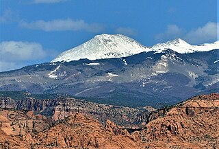
WMount Tukuhnikivatz is a 12,482-foot elevation summit located in San Juan County of Utah, United States. Mount Tukuhnikivatz is the third-highest peak of the La Sal Mountains, and is the premier ski mountaineering destination in the La Sals. It is situated in a dry, rugged, sparsely settled region, and set on land administered by Manti-La Sal National Forest. Precipitation runoff from this mountain drains into tributaries of the Colorado River. The nearest town is Moab, 19 mi (31 km) to the northwest, and the nearest higher neighbor is Mount Peale, 1.7 mi (2.7 km) to the east. The mountain's name is a Native American word that translates as "Where the sun sets last." Locals call it Mount Tuk for short. This mountain has a subsidiary peak unofficially called Little Tuk, approximately one half mile to the north-northwest.