 W
WThe Devil's Cave is a dripstone cave located in the town of Pottenstein, Bavaria, Germany. The cave is 1,500 metres (4,900 ft) long and is the longest in Germany and the largest in Franconian Switzerland.
 W
WThe Easter Cave is a small cave in the vicinity of Trondorf in Germany. The cave is 185 metres long and may be visited during the summer months. It was first mentioned in the records around 1630. The present entrance was artificially created in 1905 in order to open it as a show cave for visitors. The Easter Cave is one of the last caves in Germany to be lit with carbide lamps. Relatively high concentrations of manganese were found on the walls. The origin of the German name, Osterhöhle, is not entirely clear, but it probably comes from the location of the cave on the Osterberg, a hill whose name in turn may possibly be connected with the German goddess of dawn, Ostara.
 W
WThe Haßberge are a hill range, up to 512.2 m above sea level (NN), north of the River Main in Lower Franconia in the German state of Bavaria. The hills are in the county of Bamberg and divided by the Main valley from their sister hills, the Steigerwald. Both forested hill ranges fall steeply down to the Main. Between the Ebelsbach and Haßfurt the river cuts through the hills in a wide gap, creating an easy route between the Upper Main and the fertile Middle Main region.
 W
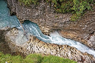
WThe Leutasch Gorge is a gorge near Mittenwald and Unterleutasch in the Bavarian-Tyrolean border area through which the Leutascher Ache river flows. It is very steep-sided and was not opened to tourists until 2006. To do this a 1.4 million euro, EU-supported, Austro-German project was undertaken to build steel walkways and bridges over a distance of 970 metres. With a total length of 1,650 metres it is the longest accessible gorge in the Eastern Limestone Alps. The gorge was opened on 24 May 2006.
 W
WThe Munich gravel plain is an Outwash plain in Upper Bavaria, Germany, formed during Late Pleistocene glacial periods. Characterized by its very wide extension, it comprises sandur terraces and the floodplain of the Isar river. These most recent deposits overlie the Neogene Molasse basin of the Alpine Foreland, which in contrast comprises fine-grained fluviatile and lacustrine facies.
 W
WThe Nördlinger Ries is an impact crater, large circular depression in western Bavaria, Germany, and eastern Baden-Württemberg, located north of the Danube in the district of Donau-Ries. The city of Nördlingen is located inside the depression, about 6 kilometers (3.7 mi) south-west of its centre.
 W
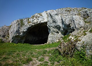
WThe Ofnet Caves are the remains of an underground karst system on the edge of the Nördlinger Ries in Germany. They are located on a limestone hill near Nördlingen, Bavaria. The caves became famous in 1908 when 33 prehistoric human skulls were discovered. The skulls were dated to the Mesolithic period.
 W
WThe Partnach Gorge is a deep gorge that has been incised by a mountain stream, the Partnach, in the Reintal valley near the south German town of Garmisch-Partenkirchen. The gorge is 702 metres (2,303 ft) long and, in places, over 80 metres (260 ft) deep. It was designated a natural monument in 1912.
 W
WThe Röthbachfall is the highest waterfall in Germany, with a vertical drop of 470 metres (1540 ft). The waterfall is located in the Berchtesgaden area on the Obersee lake. One way to visit the waterfall is to take the electric boat across lake Königssee to Salet and then to hike up to the Obersee. This remote location has led to the erroneous claim that the highest waterfall in Germany is the more accessible Triberg Waterfall even though Triberg has a drop of only 163 metres.