 W
WThe French Geodesic Mission to Lapland was one of the two French Geodesic Mission carried out in 1736–1737 by the French Academy of Sciences for measuring the shape of the Earth. One expedition was sent to Ecuador to perform measurements near the Equator, another one was sent to Meänmaa to perform measurements near the Arctic Circle.
 W
WThe Great Trigonometrical Survey was a project which aimed to measure the entire Indian subcontinent with scientific precision. It was begun in 1802 by the British infantry officer William Lambton, under the auspices of the East India Company. Under the leadership of his successor, George Everest, the project was made the responsibility of the Survey of India. Everest was succeeded by Andrew Scott Waugh and after 1861 the project was led by James Walker, who oversaw its completion in 1871.
 W
WThe Josephinian Land Survey was the first comprehensive land survey and mapping of the Habsburg Empire. The survey was ordered by Holy Roman Empress Maria Theresa after Austria's defeat in the Seven Years' War. It was conducted from 1763 to 1787, concluding in the reign of Holy Roman Emperor Joseph II. The maps are currently stored in the National Archives of Austria.
 W
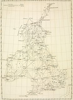
WThe Principal Triangulation of Britain was the first high-precision trigonometric survey of the whole of Great Britain, carried out between 1791 and 1853 under the auspices of the Board of Ordnance. The aim of the survey was to establish precise geographical coordinates of almost 300 significant landmarks which could be used as the fixed points of local topographic surveys from which maps could be drawn. In addition there was a purely scientific aim in providing precise data for geodetic calculations such as the determination of the length of meridian arcs and the figure of the Earth. Such a survey had been proposed by William Roy (1726–1790) on his completion of the Anglo-French Survey but it was only after his death that the Board of Ordnance initiated the trigonometric survey, motivated by military considerations in a time of a threatened French invasion. Most of the work was carried out under the direction of Isaac Dalby, William Mudge and Thomas Frederick Colby, but the final synthesis and report (1858) was the work of Alexander Ross Clarke. The survey stood the test of time for a century, until the Retriangulation of Great Britain between 1935 and 1962.
 W
WThe retriangulation of Great Britain was a triangulation project carried out between 1935 and 1962 that sought to improve the accuracy of maps made of Great Britain. Data gathered from the retriangulation replaced data gathered during the Principal Triangulation of Great Britain, which had been performed between 1783 and 1851. The retriangulation involved erecting around 6,500 concrete pillars on British hilltops, which were used as reference points for the triangulation. Today, use of the trig points and the results of the retriangulation have been replaced by a network of global navigation satellite system stations known as OS Net, which is able to achieve an accuracy of 3 millimetres (0.12 in) over the length of the country compared to 20 metres (66 ft) achievable by use of the trig points.
 W
WThe Schiehallion experiment was an 18th-century experiment to determine the mean density of the Earth. Funded by a grant from the Royal Society, it was conducted in the summer of 1774 around the Scottish mountain of Schiehallion, Perthshire. The experiment involved measuring the tiny deflection of the vertical due to the gravitational attraction of a nearby mountain. Schiehallion was considered the ideal location after a search for candidate mountains, thanks to its isolation and almost symmetrical shape.
 W
WThe Struve Geodetic Arc is a chain of survey triangulations stretching from Hammerfest in Norway to the Black Sea, through ten countries and over 2,820 km, which yielded the first accurate measurement of a meridian.
 W
WThe Transcontinental Traverse (TCT) was a geodetic survey traverse conducted in the Continental United States by the U.S. Coast and Geodetic Survey between 1961 and 1976. It was the most accurate large-area survey ever done prior to Global Positioning System surveys. TCT included over 2,700 survey stations, covered over 13,600 miles, and passed through 44 states.
 W
WIn surveying, triangulation is the process of determining the location of a point by measuring only angles to it from known points at either end of a fixed baseline, rather than measuring distances to the point directly as in trilateration. The point can then be fixed as the third point of a triangle with one known side and two known angles.