 W
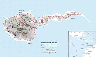
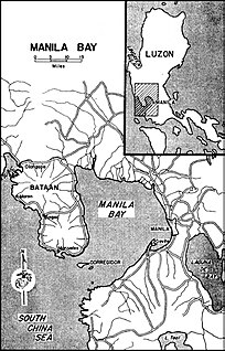
WCorregidor Island is an island located at the entrance of Manila Bay in southwestern part of Luzon Island in the Philippines. Due to this location, Corregidor has historically been fortified with coastal artillery to defend the entrance of Manila Bay and Manila from attacks by enemy warships. Located 48 kilometres (30 mi) inland, Manila has been the largest city and the most important seaport in the Philippines for centuries, from the colonial rule of Spain, Japan and the United States, to the establishment of the Philippines in 1946.
 W
WBattery Way was a battery of four 12-inch mortars located on the island of Corregidor. Battery Way was one of two mortar batteries at Fort Mills that, with Fort Hughes, Fort Drum, Fort Frank and Fort Wint formed the Harbor Defenses of Manila and Subic Bays. Battery Way was named for Lt. Henry N. Way of the 4th U.S. Artillery.
 W
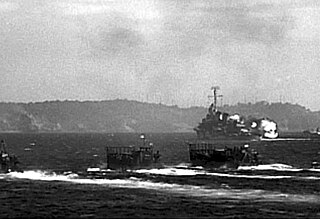
WThe Battle for the Recapture of Corregidor, which occurred on the 16th until the 26th of February, 1945, pitted American forces against the defending Japanese garrison on the island fortress. The Japanese had captured the bastion from the United States Army Forces in the Far East during their 1942 invasion.
 W
WThe Battle of Corregidor, fought May 5–6, 1942, was the culmination of the Japanese campaign for the conquest of the Commonwealth of the Philippines during World War II.
 W
WCorregidor Caldera is an extinct volcanic caldera located at the entrance to Manila Bay in the Philippines. The caldera is composed of the islands of Corregidor and Caballo in the province of Cavite, which are believed to be the exposed rim of the volcano.
 W
WThe first Corregidor Island Lighthouse was a historic lighthouse located on the island of Corregidor, in the province of Cavite, Philippines. The light station was one of the most important lights in the archipelago. It was established in 1853 to guide ships to the entrance of Manila Bay on their way to the port of Manila, the most important trading center in the country. This light occupies the converging point of two lines of approach for vessels from the China Sea which steer for the entrance of the Manila Bay. Vessels from Hong Kong and the ports of China to the northwest first sight the Capones Island light off the southwest coast of Zambales. Vessels from ports of Indo-China first sight the Corregidor lights in the center. Vessels from Singapore, Indonesia, India, and all the ports of the Philippine Islands, to the south, first sight the Cabra Island light. All lines converge on Corregidor light at the bay entrance.
WFort Mills was the location of US Major General George F. Moore's headquarters for the Philippine Department's Harbor Defenses of Manila and Subic Bays in early World War II, and was the largest seacoast fort in the Philippines. Most of this Coast Artillery Corps fort was built 1904–1910 by the United States Army Corps of Engineers as part of the Taft program of seacoast defense. The fort was named for Brigadier General Samuel Meyers Mills Jr., Chief of Artillery 1905–1906. It was the primary location of the Battle of Corregidor in the Japanese invasion of the Philippines in 1941–42, and of the recapture of Corregidor in February 1945, both in World War II.
 W
WThe Harbor Defenses of Manila and Subic Bays were a United States Army Coast Artillery Corps harbor defense command, part of the Philippine Department of the United States Army from circa 1910 through early World War II. The command primarily consisted of four forts on islands at the entrance to Manila Bay and one fort on an island in Subic Bay.
 W
WThe Malinta Tunnel is a tunnel complex built by the United States Army Corps of Engineers on the island of Corregidor in the Philippines. It was initially used as a bomb-proof storage and personnel bunker, but was later equipped as a 1,000-bed hospital. The main tunnel, running east to west, is 831 feet (253 m) long, 24 feet (7.3 m) wide and 18 feet (5.5 m) high. Branching off from this main shaft are 13 lateral tunnels on the north side and 11 lateral tunnels on the south side. Each lateral averaged 160 feet (49 m) in length and 15 feet (4.6 m) in width.