 W
WCoyote Buttes is a section of the Paria Canyon-Vermilion Cliffs Wilderness managed by the Bureau of Land Management (BLM), spanning extreme south-central Utah and north-central Arizona, south of US 89 halfway between Kanab, Utah and Page, Arizona. It is divided into two areas: Coyote Buttes North and Coyote Buttes South. Visiting either of the Coyote Buttes areas requires purchasing a hiking permit.
 W
WDouble Mountains is the name of a pair of flat-topped buttes located 13 miles (21 km) southwest of Aspermont in Stonewall County, Texas. While the Handbook of Texas gives their elevation as either 2,000 ft (610 m) or 2,400 ft (732 m), United States Geological Survey maps give the elevation of the western mountain as 2,523 ft (769 m) and that of the eastern mountain as between 2,580 ft (786 m) and 2,600 ft (792 m). Together, the mountains form part of the high ground dividing the watersheds of the Salt Fork and Double Mountain Fork Brazos River.
 W
WEnchanted Mesa is a sandstone butte in Cibola County, New Mexico, United States, about 2.5 miles (4.0 km) northeast of the pueblo of Acoma. It is called Mesa Encantada in Spanish and Katzimo or Kadzima in Keresan. Acoma tradition says that Enchanted Mesa was the home of the Acoma people until a severe storm and landslide destroyed the only approach. There are no longer any ruins on the flat top. The butte is 430 ft (130 m) high, 1,250 ft (380 m) long and only 400 ft (120 m) ft wide, at its widest. The elevation at the top is 6,643 ft (2,025 m).
 W
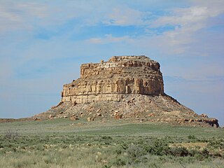
WFajada Butte is a butte in Chaco Culture National Historical Park, in northwest New Mexico.
 W
WThe Glass Mountains are not actually mountains, but a series of mesas and buttes that are part of the Blaine Escarpment that extends from the Permian red beds of northwestern Oklahoma in Major County. The Glass Mountains rise 150 feet (46 m) to 200 feet (61 m) above the surface of the plains, and the highest elevation in the formation is about 1,600 feet (490 m) above sea level. The Glass Mountains stretch west along U.S. Route 412 from Orienta south of the Cimarron River. The name comes from the sparkling selenite crystals on the slopes and tops of the mesas.
 W
WPahvant Butte is a butte formed by a dormant volcano in the west-central portion of Utah, United States.
 W
WShadow Butte is a mountain butte, located in the southwestern region of the U.S. state of Idaho.
 W
WTabernacle Hill is a butte formed by a dormant volcano in the west-central portion of Utah, United States.
 W
WThe Cinders is a lava field including a volcanic hill named Ice Springs craters in the west-central portion of Utah, United States. It is also known as the Ice Springs Volcanic Field.