 W
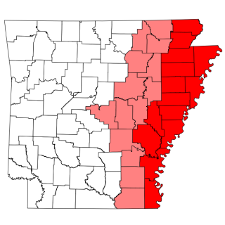
WThe Arkansas Delta is one of the six natural regions of the state of Arkansas. Willard B. Gatewood Jr., author of The Arkansas Delta: Land of Paradox, says that rich cotton lands of the Arkansas Delta make that area "The Deepest of the Deep South."
 W
WThe Arkansas River Valley is a region in Arkansas defined by the Arkansas River in the western part of the state. Generally defined as the area between the Ozark and Ouachita Mountains, the River Valley is characterized by flat lowlands covered in fertile farmland and lakes periodically interrupted by high peaks. Mount Magazine, Mount Nebo, and Petit Jean Mountain compose the Tri-Peaks Region, a further subdivision of the River Valley popular with hikers and outdoors enthusiasts. In addition to the outdoor recreational activities available to residents and visitors of the region, the River Valley contains Arkansas's wine country as well as hundreds of historical sites throughout the area. It is one of six natural divisions of Arkansas.
 W
WThe Gulf Coastal Plain extends around the Gulf of Mexico in the Southern United States and eastern Mexico.
 W
WThe "Little Rock" is the eponym of Little Rock, Arkansas. It is a now-reduced stone outcrop, projecting into the Arkansas River from its south bank, in the city's waterfront area, adjacent to the Junction Bridge, whose foundations include a portion of the rock. A portion of the rock outcrop has had a bronze plaque mounted on it. The rock, originally estimated to rise about 18 feet (5.5 m) above the river, was first identified as a significant river landmark in 1722 by French explorer Jean-Baptiste Bénard de la Harpe. In 1818 the rock was used as a survey marker, and formed the starting point for land surveys in the region south of the river.
 W
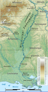
WThe Mississippi River Alluvial Plain is an alluvial plain created by the Mississippi River on which lie parts of seven U.S. states, from southern Louisiana to southern Illinois.
 W
WThe Mississippi Embayment is a physiographic feature in the south-central United States, part of the Mississippi Alluvial Plain. It is essentially a northward continuation of the fluvial sediments of the Mississippi River Delta to its confluence with the Ohio River at Cairo, Illinois. The current sedimentary area was formed in the Cretaceous and early Cenozoic by the filling with sediment of a pre-existing basin. An explanation for the embayment's formation was put forward by Van Arsdale and Cox in 2007: movement of the earth's crust brought this region over a volcanic "hotspot" in the Earth's mantle causing an upthrust of magma which formed the Appalachian-Ouachita range. Subsequent erosion caused a deep trough that was flooded by the Gulf of Mexico and eventually filled with sediment from the Mississippi River.
 W
WPinnacle Mountain is the second highest natural point in Pulaski County, Arkansas and main attraction of the 2,356-acre Pinnacle Mountain State Park. It is located in the foothills of the Ouachita Mountains just outside of Little Rock, the capital and most populous city of Arkansas.
 W
WShinall Mountain is the highest natural point in Pulaski County, Arkansas and home to a number of broadcast towers whose navigational lights can be seen for miles. It is located in the foothills of the Ouachita Mountains on the edge of Little Rock, the capital and most populous city of Arkansas.