 W
WBrocks Gap is a water gap in Rockingham County, Virginia, where the North Fork of the Shenandoah River flows through Little North Mountain. The gap was the proposed site of the never-built Brocks Gap Dam and is traversed by Virginia Route 259.
 W
WGoshen Pass is a water gap, or gorge, in the Little North Mountain, formed by the passage of the Maury River, approximately 20 miles (32 km) northwest of Lexington in Rockbridge County, Virginia. State Route 39 traverses the pass along the banks of the Maury River.
 W
WHillsboro Gap, also known as the Gap in the Short Hill is a water gap in the Short Hill Mountain formed by the North Fork of the Catoctin Creek in Loudoun County, Virginia. The gap derives its name from the town of Hillsboro, which is nestled in the gap. Virginia State Route 9 passes through the gap in the town.
 W
WThe James River Gorge is a water gap created by the James River in Central Virginia. The Gorge is 2,433 feet (742 m) deep as measured from Highcock Knob 3,073 feet (937 m) to the James River 640 feet (200 m) and is approximately 9.3 miles (15.0 km) long. The James River forms in western Virginia near the border of West Virginia and initially flows south through the ridge and valley province of the Allegheny Mountains, turning northeast when it comes to the western edge of the Blue Ridge Mountains near Buchanan, Virginia. From Buchanan the river flows along the base of the Blue Ridge Mountains until it joins the Maury River near the town of Glasgow and then it turns southeast and begins its descent over the Balcony Falls rapids and through the James River Gorge. The rocks of the gorge are metamorphic in nature with the oldest exposed outcrops being from the Proterozoic Era. To the south of the river the peaks of the James River Face Wilderness dominate and to the north the peaks of Big Rocky Row and Little Rocky Row Mountains form a dramatic backdrop to the river far below. Multiple trails, including the Appalachian Trail go through the gorge and provide spectacular vistas of the scenery both at river level and from the peaks to the north and the south.
 W
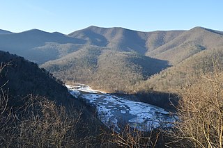
WMoccasin Gap, also known as Big Moccasin Gap, is a pass in Clinch Mountain, a long ridge within the Appalachian Mountains, at Gate City, Virginia. This gap has a long history as a passageway through the mountain. It was used by the Cherokee and Shawnee, and was the first gap through which the Daniel Boone Wilderness Road passed on its way to the better-known Cumberland Gap and Kentucky. Today it serves as a primary commercial route for industry, retail, and tourism businesses.
 W
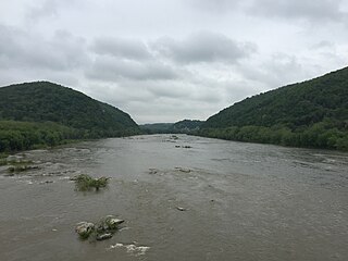
WThe Potomac Water Gap is a double water gap in the Blue Ridge Mountains, located at the intersection of the states of Virginia, West Virginia and Maryland, near Harpers Ferry. At 256 feet (78 m), it is the lowest crossing of the Blue Ridge Mountains.
WThoroughfare Gap is a water gap in the Bull Run Mountains created by Broad Run between High Point Mountain to the north and Bisquit Mountain to the south. It is located on the border of Prince William and Fauquier counties in Virginia.