 W
WThe St. Francois Mountains in southeast Missouri are a mountain range of Precambrian igneous mountains rising over the Ozark Plateau. This range is one of the oldest exposures of igneous rock in North America. The name of the range is spelled out as Saint Francois Mountains in official GNIS sources, but it is sometimes misspelled in use as St. Francis Mountains to match the anglicized pronunciation of both the range and St. Francois County.
 W
WThe United States Congress designated the Bell Mountain Wilderness in 1980. The wilderness area now has a total of 9,027 acres (36.53 km2). Bell Mountain is located within the Potosi-Fredericktown Ranger District of the Mark Twain National Forest, south of Potosi, Missouri in the United States. The wilderness lies in the Saint Francois Mountains and it was named after its highest point, Bell Mountain. The namesake Bell Mountain has the name of Henry Bell, a pioneer settler. The Bell Mountain Wilderness is one of eight wilderness areas protected and preserved in Missouri. The area is popular for hiking as there are 12 miles (19 km) of trail, including a section of the Ozark Trail.
 W
WThe Bonneterre Formation is an Upper Cambrian geologic formation which outcrops in the St. Francois Mountains of the Missouri Ozarks. The Bonneterre is a major host rock for the lead ores of the Missouri Lead Belt.
 W
WHughes Mountain and the Hughes Mountain State Natural Area are located in southern Washington County, Missouri just south of the Big River and Highway M on Cedar Creek Road in the St. Francois Mountains range of The Ozarks. The mountain reaches an elevation of just over 1,200 feet, rising 430 feet above the Big River. The Hughes Mountain Natural Area of the Missouri Department of Conservation encompasses 462 acres (1.87 km2) of the mountain, including the rhyolite glade at its top.
 W
WPilot Knob is located in the Arcadia Valley of Iron County, Missouri, between the towns of Ironton and Pilot Knob. Pilot Knob, so named because of its distinctive shape and prominent position, reaches an elevation of 1,470 feet (450 m) rising 581 feet (177 m) above the Arcadia Valley floor and has a large deposit of iron ore in its upper regions. Pilot Knob is a peak in the St. Francois Mountains.
 W
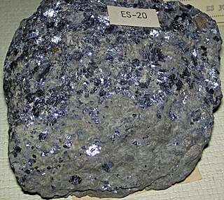
WThe Southeast Missouri Lead District, commonly called the Lead Belt, is a lead mining district in the southeastern part of Missouri. Counties in the Lead Belt include Saint Francois; Crawford; Dent; Iron; Madison: Reynolds; and Washington. Philip Francois Renault of France led a large exploratory mission in 1719 and started mining operations in Old Mines and Mine La Motte in 1720. The town of Sainte Genevieve was founded as a river port for transportation of lead out of the area. Moses Austin started large-scale mining and smelting at Potosi, originally known as Mine a Breton, and founded Herculaneum as his shipping point on the Mississippi. This lead was originally used as a roofing material. Bonne Terre has large subterranean mines, now used commercially for recreational scuba diving.
 W
WTaum Sauk Mountain in the Saint Francois Mountains is the highest natural point in the U.S. state of Missouri at 1,772 feet . The topography of Taum Sauk is that of an elongated ridge with a NNW-SSE orientation rather than a peak.