 W
WThe Alamo bolide impact occurred 377-378 million years ago, when one or more hypervelocity objects from space slammed into shallow marine waters at a site that is now the Devonian Guilmette Formation of the Worthington Mountains and Schell Creek Range of southeastern Nevada; the event is named for breccias of metamorphosed crushed rock deposits, found as far as the town of Alamo, Nevada. This catastrophic impact event resulted in what is one of the best-exposed and has become the most accurately dated impact events; it occurred within the Frasnian age of the Devonian at about 377-378Ma Ma, a moment in time that was about 5.9 Ma prior to the Frasnian/Famennian extinction events, which it is unlikely to have affected.
 W
WThe Columbia River drainage basin is the drainage basin of the Columbia River in the Pacific Northwest region of North America. It covers 668,000 km2 or 258,000 sq mi. In common usage, the term often refers to a smaller area, generally the portion of the drainage basin that lies within eastern Washington.
 W
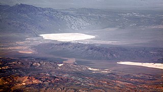
WGroom Lake is a dry lake, also described as a salt flat, in Nevada. It is used for runways of the Nellis Bombing Range Test Site airport (KXTA). Part of the Area 51 USAF installation, it lies at an elevation of 4,409 ft (1,344 m) and is approximately 3.7 miles (6.0 km) from north to south and 3 miles (4.8 km) from east to west at its widest point, and is approximately 11.3 miles in circumference. Located within the namesake Groom Lake Valley portion of the Tonopah Basin, the lake is 25 mi (40 km) south of Rachel, Nevada.
 W
WMormon Mesa is a mesa between the Virgin River and the Muddy River in Clark County, southern Nevada.
WPapoose Lake is a dry lake bed located in Lincoln County, Nevada, U.S. The lake lies within the plot of land referred to as the Groom Lake facility and is a restricted area. The lake is located a few miles southwest of the Groom Lake facility nestled adjacent the Papoose Range.
 W
WSand Mountain is a singing sand dune 20 miles (32 km) east of Fallon, Nevada along U.S. Route 50. The dune is two miles long and 600 feet (180 m) high. The sand originates from the ancient Lake Lahontan, that for the most part dried up 9,000 years ago. Sand Mountain Recreation Area is managed by the Bureau of Land Management and is open to off-highway vehicle use. The area is also the only home of the "critically imperiled" Sand Mountain blue butterfly. The ruins of the Sand Springs Station of the Pony Express are also located within the recreation area.Off-road vehicle rulesCamp only in designated areas. 8 feet (2.4 m) whip flags are required on all vehicles riding in the dunes. Do not burn wood containing nails, screws or other metal hardware. Burning tires is prohibited. Speed limit is 15 miles per hour (24 km/h) in camping areas. Possession or use of any glass cup or bottle is not allowed. Users must pay an area fee of $90 per year or $40 per week collected by the Bureau of Land Management. Avoid riding in areas closed to motor vehicles.
 W
WThe Winnemucca Sand Dunes are an area of sand dunes in Humboldt County, Nevada. While less than 100 feet (30 m) tall, the dunes span an area of approximately 40 miles (64 km) from east to west across the southern portion of the county. They are located north of the city of Winnemucca, their namesake, along U.S. Route 95. Ownership of the dunes is a checkerboard mixture of private holdings and BLM land. Activities on the dunes include sightseeing and ATV riding.