 W
WThe Bonneville Salt Flats are a densely packed salt pan in Tooele County in northwestern Utah. The area is a remnant of the Pleistocene Lake Bonneville and is the largest of many salt flats located west of the Great Salt Lake. The property is public land managed by the Bureau of Land Management and is known for land speed records at the "Bonneville Speedway". Access to the flats is open to the public.
 W
WThe Escalante Desert is a geographic Great Basin region and arid desert ecoregion, in the deserts and xeric shrublands biome, located in southwestern Utah.
 W
WThe Great Basin Desert is part of the Great Basin between the Sierra Nevada and the Wasatch Range. The desert is a geographical region that largely overlaps the Great Basin shrub steppe defined by the World Wildlife Fund, and the Central Basin and Range ecoregion defined by the U.S. Environmental Protection Agency and United States Geological Survey. It is a temperate desert with hot, dry summers and snowy winters. The desert spans a large part of the state of Nevada, and extends into western Utah, eastern California, and Idaho. The desert is one of the four biologically defined deserts in North America, in addition to the Mojave, Sonoran, and Chihuahuan Deserts.
 W
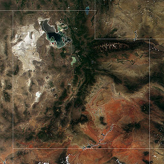
WThe Great Salt Lake Desert is a large dry lake in northern Utah, United States, between the Great Salt Lake and the Nevada border which is noted for white evaporite Lake Bonneville salt deposits.
 W
WThe Mojave Desert is an arid rain-shadow desert and the driest desert in North America. It is in the Southwestern United States, primarily within southeastern California and southern Nevada, and it occupies 47,877 sq mi (124,000 km2). Small areas also extend into Utah and Arizona. Its boundaries are generally noted by the presence of Joshua trees, which are native only to the Mojave Desert and are considered an indicator species, and it is believed to support an additional 1,750 to 2,000 species of plants. The central part of the desert is sparsely populated, while its peripheries support large communities such as Las Vegas, Nevada, Barstow, Lancaster, Palmdale, and Victorville, California, and St. George, Utah.
 W
WThe Sevier Desert is a large arid section of central-west Utah, United States, and is located in the southeast of the Great Basin. It is bordered by deserts north, west, and south; its east border is along the mountain range and valley sequences at the perimeter of the Great Basin, with the large north-south Wasatch Range and its associated mountainous landforms. Its eastern border is specifically, the East Tintic, Gilson, and Canyon Mountains; also the massive Pahvant Range.
 W
WThe Wyoming Basin shrub steppe ecoregion, within the deserts and xeric shrublands biome, is a shrub steppe in the northwestern United States.