 W
WAiken's Wash is an archaeologically and geologically significant wash located in the Mojave National Preserve in San Bernardino County, California. The wash includes several pictograph and petroglyph sites dating from the late pre-Columbian period. The proximity of pictographs and petroglyphs is unusual in the Mojave Desert region. The area was added to the National Register of Historic Places as the Aiken's Wash National Register District. The district comprises 1,450 acres (590 ha), including all major archaeological sites in the wash.
 W
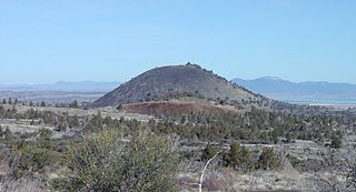
WAmboy Crater is an extinct cinder cone volcano that rises above a 70-square-kilometer (27 sq mi) lava field in the eastern Mojave Desert of southern California, within Mojave Trails National Monument.
 W
WBald Knoll, also called Black Knoll, Buck Knoll or Corral Knoll, is a cinder cone in Utah, in the Southwestern United States.
 W
WBelknap Crater is a shield volcano in the Cascade Range in the U.S. state of Oregon. Located in Linn County, it is associated with lava fields and numerous subfeatures including the Little Belknap and South Belknap volcanic cones. It lies north of McKenzie Pass and forms part of the Mount Washington Wilderness. Belknap is not forested and most of its lava flows are not vegetated, though there is some wildlife in the area around the volcano, as well as a number of tree molds formed by its eruptive activity.
 W
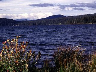
WThe Big Lava Bed, located in the Gifford Pinchot National Forest in the southwestern area of the State of Washington, originated from a 500-foot-deep crater in the northern center of the bed. The Big Lava Bed is the youngest feature of the Indian Heaven volcanic field. The 0.9-cubic kilometer lava flow erupted from the cinder cone about 8200 years ago. The lava flow traveled 13 km from the source crater. Lodgepole pine, alder, and other pioneer plants struggle to grow, seen sparsely growing between and amid towering rock piles, caves, and strange lava formations. Access into the interior of the lava bed is difficult, since there are no roads or trails crossing the lava field. Explorers who wish to venture deep within the lava flow are advised to choose their route carefully. Compasses are not always reliable, since local magnetic influences affect their magnetic performance in the vast expanse of rock.
 W
WBlack Bottom Crater is a volcanic crater located in Arizona, east-northeast of Sunset Crater, and west-southwest of Roden Crater. To the northwest is Strawberry Crater. Black Bottom Crater is a cinder cone in the San Francisco volcanic field.
 W
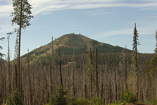
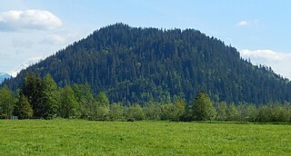
WBrown Mountain is a small cinder cone on top of a shield volcano located in Cascade Volcanic Arc in Klamath and Jackson counties, Oregon. Most of the mountain, including its peak, is in western Klamath County, but its western flanks trail off into eastern Jackson County. It is 7,344 feet (2,238 m) above sea level, but is overshadowed by nearby 9,495-foot (2,894 m) Mount McLoughlin.
 W
WCapulin Volcano National Monument is a U.S. National Monument located in northeastern New Mexico that protects and interprets an extinct cinder cone volcano and is part of the Raton-Clayton Volcanic Field. A paved road spirals gradually around the volcano and visitors can drive up to a parking lot at the rim of the extinct volcano. Hiking trails circle the rim as well as lead down into the mouth of the volcano. The monument was designated on August 9, 1916 and is administered by the National Park Service. The volcano is located 5 kilometres (3.1 mi) north of the village of Capulin.
 W
WCinder Cone is a cinder cone volcano in Lassen Volcanic National Park within the United States. It is located about 10 miles (16 km) northeast of Lassen Peak and provides an excellent view of Brokeoff Mountain, Lassen Peak, and Chaos Crags.
 W
WCinnamon Butte is a group of cinder cone volcanoes and lava domes in the Cascade Range of Oregon. All of the vents are older than approximately 6,845 years as they are all covered in ash from the eruption of Mount Mazama.
 W
WThe Davis Lake volcanic field, is a volcanic field with a group of andesitic cinder cones, lava flows and basaltic andesite shield volcanos east of the Cascade Range of Oregon, United States.
 W
WMount Gordon is a cinder cone in the Wrangell Mountains of eastern Alaska, United States, located between Nabesna Glacier and the stratovolcano Mount Drum. It is the most prominent of a group of Pleistocene and Holocene cinder cones, most of which are less than 100 m (328 ft) high. The exact age of Mount Gordon remains unknown.
 W
WHoodoo Butte is a cinder cone butte in the Cascade Range of northern Oregon, located near Santiam Pass. Immediately to the east lies Hayrick Butte, a prime example of a tuya; the two mountains' names were likely mistaken for each other, but stuck with them over time. The area has been subjected to a number of historic fires. Hoodoo is sometimes considered a subfeature of the Mount Washington shield volcano, and it forms part of the Sisters Reach, which extends from South Cinder Peak to Crane Prairie Reservoir, running for 56 miles (90 km). This region has a high vent density, with many mafic volcanoes of Pleistocene to Holocene age, such as Hoodoo. While Hoodoo has an intact summit crater that was blocked from erosion by glaciers, it has an irregular topography, giving it an open appearance.
 W
WThe Ingakslugwat Hills volcanic field is in the Yukon–Kuskokwim Delta in western Alaska. It contains eight large craters and about thirty small pyroclastic cones in an area of some 500 km2. The field contains unusual so-called "Ingakslugwat volcanoes", volcanic ridges up to 7 kilometres (4.3 mi) long and 400 metres (1,300 ft) high which are formed by pyroclastic material. They most likely formed by the interaction of permafrost with magma, seeing as they have a hydrovolcanic nature despite being high above the water table.
 W
WKahauloa Crater is a tuff cone located in Hawaii. It sits between Koko Crater and Hanauma Bay. The Koko Head Shooting Complex operates in its crater.
WKaʻau Crater is an extinct volcanic crater located in the U.S. state of Hawaii near Palolo Valley.
 W
WKiska is an island in the Rat Islands group of the Aleutian Islands of Alaska. It is about 22 miles (35 km) long and varies in width from 1.5 to 6 miles. It is part of Aleutian Islands Wilderness and as such, special permissions are required to visit it. The island has no permanent population.
 W
WLava Beds National Monument is located in northeastern California, in Siskiyou and Modoc counties. The monument lies on the northeastern flank of Medicine Lake Volcano and has the largest total area covered by a volcano in the Cascade Range.
 W
WLava Butte is a cinder cone in central Oregon, United States, just west of U.S. Route 97 between the towns of Bend, Oregon, and Sunriver, Oregon. It is part of a system of small cinder cones on the northwest flank of Newberry Volcano, a massive shield volcano which rises to the southeast. The cinder cone is capped by a crater which extends about 60 feet (20 m) deep beneath its south rim, and 160 feet (50 m) deep from the 5,020-foot (1,530 m) summit on its north side. Lava Butte is part of the Newberry National Volcanic Monument.
 W
WThe Lavic Lake volcanic field is a volcanic field with extinct cinder cones in the Mojave Desert, in San Bernardino County, California, United States. The lava field, at 762 m (2,500 ft) elevation, and its cones are directly alongside historic Route 66 and from Interstate 40, between Barstow to the west and Ludlow to the east, and is located 10 miles directly west of Ludlow, California.
 W
WMaiden Peak is a steep-sided shield volcano in the Cascade Range of central Oregon. It is the highest point in the 43-mile (69 km) distance between Mount Bachelor and Diamond Peak. Ice Age glaciers carved a large cirque into the northeast flank of the mountain, exposing magma which hardened in the volcano's conduits to form the numerous rock pinnacles now found in the upper part of the cirque.
 W
WMount McLoughlin is a dormant steep-sided stratovolcano, or composite volcano, in the Cascade Range of southern Oregon and within the Sky Lakes Wilderness. It is one of the volcanic peaks in the Cascade Volcanic Arc, within the High Cascades sector. A prominent landmark for the Rogue River Valley, the mountain is north of Mount Shasta, and Crater Lake lies to the north-northeast. It was named around 1838 after John McLoughlin, a Chief Factor for the Hudson's Bay Company. Mount McLouglin's prominence has made it a landmark to Native American populations for thousands of years.
 W
WThe Mono–Inyo Craters are a volcanic chain of craters, domes and lava flows in Mono County, Eastern California. The chain stretches 25 miles (40 km) from the northwest shore of Mono Lake to the south of Mammoth Mountain. The Mono Lake Volcanic Field forms the northernmost part of the chain and consists of two volcanic islands in the lake and one cinder cone volcano on its northwest shore. Most of the Mono Craters, which make up the bulk of the northern part of the Mono–Inyo chain, are phreatic volcanoes that have since been either plugged or over-topped by rhyolite domes and lava flows. The Inyo volcanic chain form much of the southern part of the chain and consist of phreatic explosion pits, and rhyolitic lava flows and domes. The southernmost part of the chain consists of fumaroles and explosion pits on Mammoth Mountain and a set of cinder cones south of the mountain; the latter are called the Red Cones.
 W
WNunivak Island is a permafrost-covered volcanic island lying about 30 miles (48 km) offshore from the delta of the Yukon and Kuskokwim rivers in the US state of Alaska, at a latitude of about 60° N. The island is 1,631.97 square miles (4,226.8 km2) in area, making it the second-largest island in the Bering Sea and eighth-largest island in the United States. It is 76.2 kilometers (47.3 mi) long and 106 kilometers (66 mi) wide. It has a population of 191 persons as of the 2010 census, down from 210 in 2000. The island's entire population lived in the north coast city of Mekoryuk.
WOld Caves Crater is a cinder cone located in Coconino National Forest, near Flagstaff, Arizona. Its name comes from the numerous small caves on the slopes of the cinder cone. The elevation of the cinder cone is 7183 ft and the prominence is 423 ft. A forest of new growth ponderosa pines cover the lower slopes of Old Caves Crater, while a pinyon-juniper forest covers the upper slopes. A trail leads to the top of Old Caves Crater, giving great views of the San Francisco Peaks and the surrounding area. In the 14th century, Native Americans built a settlement on top of Old Caves Crater. The remains of the settlement can be found on top of Old Caves Crater.
 W
WPanum Crater is a volcanic cone that is part of the Mono–Inyo Craters, a chain of recent volcanic cones south of Mono Lake and east of the Sierra Nevada, in California, United States. Panum Crater is between 600 and 700 years old, and it exhibits all of the characteristics of the textbook rhyolitic lava dome.
 W
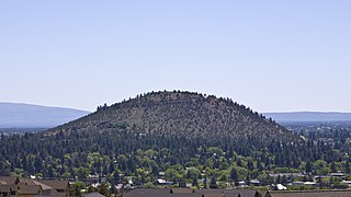
WPilot Butte is a lava dome that was created from an extinct volcano located in Bend, Oregon. It is a cinder cone butte which rises nearly 500 feet (150 m) above the surrounding plains. Bend is one of four cities in the United States to have a volcano within its boundaries. Portland, with Mount Tabor, is the only other city in Oregon with a volcano within its city limits. Jackson Volcano in Jackson, Mississippi, and Diamond Head in Honolulu are the others.
 W
WPinnacle Peak, also known as Mount Peak, is a 1,801 ft forest-covered summit located in King County of Washington state. It is part of the Cascade Range and is set at the western edge of the range, immediately south of Enumclaw, Washington and 25 miles northwest of Mount Rainier. There is also another summit named Pinnacle Peak in the Tatoosh Range to the south of Mount Rainier.
 W
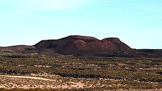
WPisgah Crater, or Pisgah Volcano, is a young volcanic cinder cone rising above a lava plain in the Mojave Desert, between Barstow and Needles, California in San Bernardino County, California. The volcanic peak is around 2.5 miles (4.0 km) south of historic U.S. Route 66-National Old Trails Highway and of Interstate 40, and west of the town of Ludlow. The volcano had a historic elevation of 2,638 feet (804 m), but has been reduced to 2,545 feet (776 m) due to mining.
 W
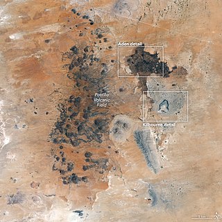
WThe Potrillo volcanic field is a monogenetic volcanic field located on the Rio Grande Rift in southern New Mexico, United States and northern Chihuahua, Mexico. The volcanic field lies 22 miles (35 km) southwest of Las Cruces, and occupies about 4,600 square kilometers (1,800 sq mi) near the U.S. border with Mexico.
 W
WPowell Butte is an extinct cinder cone butte in Portland, Oregon, United States. It is part of the Boring Lava Field, which includes more than 80 small volcanic edifices and lava flows in the Portland–Vancouver metropolitan area. The region around Powell Butte has a cool climate, and the butte and its surroundings feature meadows, rivers, and mixed forests. Powell Butte hosts the Powell Butte Nature Park, which includes about 612 acres (2.48 km2) of trails for biking, hiking, and horseback riding.
 W
WPuʻu Hawaiʻiloa is a cinder cone located in Honolulu County, Hawaii on the Mokapu Peninsula.
 W
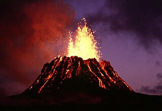
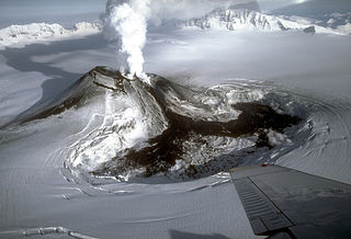
WPuʻu ʻŌʻō is a volcanic cone in the eastern rift zone of the Kīlauea volcano of the Hawaiian Islands. Until the end of April 2018, Puʻu ʻŌʻō had been erupting nearly continuously since January 3, 1983, making it the longest-lived rift-zone eruption of the last two centuries.
 W
WThe Red Cones are a pair of cinder cones near Devils Postpile National Monument, in eastern Madera County of central California. They are within the eastern Sierra Nevada and Inyo National Forest.
 W
WRed Mountain is a volcanic cinder cone located in the Coconino National Forest of northern Arizona, United States, 25 miles northwest of Flagstaff. It rises 1,000 feet (300 m) above the surroundings terrain and is shaped like the letter "U", with its opening towards the west. Geological Survey (USGS) and Northern Arizona University scientists suggest that Red Mountain was formed in eruptions nearly 740,000 years ago.
 W
WRocky Butte is an extinct cinder cone butte in Portland, Oregon, United States. It is also part of the Boring Lava Field, a group of volcanic vents and lava flows throughout Oregon and Washington state. The volcano erupted between 285,000 and 500,000 years ago.
 W
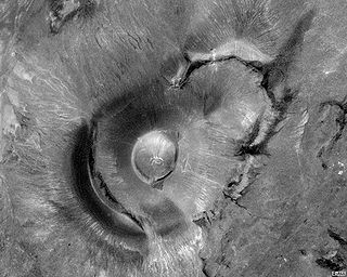
WRoden Crater is a cinder cone type of volcanic cone from an extinct volcano, with a remaining interior volcanic crater. It is located approximately 50 miles northeast of the city of Flagstaff in northern Arizona, United States.
 W
WS P Crater is a cinder cone volcano in the San Francisco volcanic field, 25 miles (40 km) north of Flagstaff, Arizona. It is surrounded by several other cinder cones which are older and more eroded. It is a striking feature on the local landscape, with a well-defined lava flow that extends for 4.3 miles (7 km) to the north.
WSaint Paul Island is the largest of the Pribilof Islands, a group of four Alaskan volcanic islands located in the Bering Sea between the United States and Russia. The village of St. Paul is the only residential area on the island. The three nearest islands to Saint Paul Island are Otter Island to the southwest, Saint George slightly to the south, and Walrus Island to the east.
 W
WSanta Clara Volcano is a volcanic field and lava flow in the Diamond Valley in Washington County, Utah, United States. The most prominent features are two cinder cones that rise above Snow Canyon State Park. The southern cinder cone and most of the north cinder cone are within the boundaries of Snow Canyon State Park. The city of St. George, Utah is located in the volcanic field. The date of the last eruption is unknown.
 W
WSchonchin Butte is a cinder cone on the northern flank of Medicine Lake Volcano in the Cascade Range in northern California. Frothy lava, cooled in the air, created the large cinder cones throughout Lava Beds National Monument. It is named for Old Schonchin, a chief of the Modoc people during the late nineteenth century. Erupting more than 30,000 years ago, the volcano spewed ash and cinders into the air much like a can of soda when shaken. A lava spatter rampart is at the very top.
 W
WSchriebers Meadow Cone is a small parasitic cone on the southeastern flank of Mount Baker in the U.S. state of Washington. It was formed about 9,800 years ago by the only known Holocene flank eruption of Mount Baker. A basaltic lava flow traveled down the Sulphur Creek valley and across the Baker River valley; this is the most recent lava flow at Mount Baker. Future eruptions from Schriebers Meadow Cone are unlikely to occur as it is considered a short-lived feature.
 W
WMount Scott is a volcanic cinder cone with its summit in Clackamas County, Oregon. The summit rises to an elevation of 1,091 feet (333 m). It is part of the Boring Lava Field, a zone of ancient volcanic activity in the area around Portland, and was named for Harvey W. Scott, a 19th and 20th century editor of The Oregonian newspaper.
 W
WSemisopochnoi Island or Unyak Island is part of the Rat Islands group in the western Aleutian Islands of Alaska. The island is uninhabited and provides an important nesting area for maritime birds. The island is of volcanic origin, containing several volcanoes including Mount Cerberus. It has a land area of 85.558 square miles, measuring 11 miles (18 km) in length and 12 miles (20 km) in width.
 W
WShastina is the highest satellite cone of Mount Shasta, and one of four overlapping volcanic cones which together form the most voluminous stratovolcano in the Cascade Range. At 12,335 feet (3,760 m), Shastina is taller than Mount Adams and would rank as the third highest volcano in the Cascades behind Mount Rainier and Shasta were it not nestled on the western flank of its higher neighbor. Shastina has a topographic prominence of over 450 ft (137 m) above the saddle connecting it with Shasta and easily exceeds the typical mountaineering standard of 300 feet (91 m) for a peak to qualify as an independent summit, yet most lists of Cascade volcanoes omit it nonetheless. The name "Shastina" is a diminutive of Shasta.
 W
WStrawberry Crater is a cinder cone volcano, more than 1,000 feet (300 m) high, in the San Francisco volcanic field, 20 miles (32 km) north of Flagstaff, Arizona. It is along Forest Road 545 between the Wupatki National Monument and Sunset Crater National Monument in the Strawberry Crater Wilderness. The crater lies in a volcanic field at a base elevation of about 5,500 feet (1,700 m), and prominence heights of about 6,526 feet (1,989 m). The northwestern end of the crater is covered with lava flows, while the southern end is filled with low cinder cones. Several of the surrounding cones include the better known, taller and younger Sunset Crater in the adjacent Sunset Crater National Monument.
WSugarloaf is a rhyolite dome located just below the San Francisco Peaks in Flagstaff, Arizona. It formed after the sideways eruption of the mountain, which occurred in a similar fashion to the 1980 eruption of Mount St. Helens.
 W
WSunset Crater is a cinder cone located north of Flagstaff in U.S. state of Arizona. The crater is within the Sunset Crater Volcano National Monument.
 W
WMount Tabor is an extinct volcanic vent, the city park on the volcano, and the neighborhood of Southeast Portland, Oregon that surrounds it. The name refers to Mount Tabor, Israel. It was named by Plympton Kelly, son of Oregon City pioneer resident Clinton Kelly.
 W
WMount Talbert is a volcanic cinder cone in Clackamas County, Oregon. It is part of the Boring Lava Field, a zone of ancient volcanic activity in the area around Portland. Its summit rises to an elevation of 740+ feet.
 W
WMount Tantalus (Puu-ohia) is an extinct cinder cone in the southern Koʻolau Range on the Hawaiian Island of Oʻahu. It also has a summit crater, Tantalus Crater. The cinder cone formed after the demise of Koʻolau Volcano, during a time of rejuvenated-stage volcanism in southeastern Oʻahu that also formed Punchbowl Crater, Diamond Head and Koko Head as part of the Honolulu Volcanics. Tantalus overlooks the modern city of Honolulu, which is built on top of Tantalus cinders.
 W
WThe Twin Buttes are a group of volcanic cinder cones located in the Cascade Mountain Range of Shasta County, California.
 W
WUlupaʻu Crater is a tuff cone in the U.S. state of Hawaii, located near Marine Corps Base Hawaii on the Mokapu Peninsula.
 W
WMount Veniaminof is an active stratovolcano on the Alaska Peninsula. The Alaska Volcano Observatory currently rates Veniaminof as Aviation Color Code ORANGE and Volcano Alert Level WATCH as of 22 November 2018, at 2005 (UTC), after it being RED/WARNING since 21 November 2018, at 1915 (UTC). The mountain was named after Ioann Veniaminov (1797–1879), a Russian Orthodox missionary priest whose writings on the Aleut language and ethnology are still standard references. He is a saint of the Orthodox Church, known as Saint Innocent for the monastic name he used in later life.
 W
WVulcan's Throne is a cinder cone volcano and a prominent landmark on the North Rim of the Grand Canyon in Arizona, United States. The volcano is adjacent the Colorado River, as it is the source material for Lava Falls and Lava Falls Rapids one of the largest rapids of the Colorado. Vulcan's Throne, about a mile (1.7 km) west of Toroweap overlook, is part of the Uinkaret volcanic field. The journals of traveler George Corning Fraser record a trip to the summit of Vulcan's Throne in 1914. At the time, the surrounding area was used for sheep grazing, and a small reservoir had been constructed at the base of the volcano. Fraser wrote thatVulcan's Throne is a pure cinder cone covered with scoriae, cinders, clinkers and peperino lying loose on the surface, with a slope, as near as I could measure, from 28° to 31°. A little sage, many cacti and perhaps some other similar low plants grow on it, but otherwise nothing. Climbing it was like ascending a sand-dune. Every step forward involved slipping half way back and boots were soon filled with painful bits of stone.
 W
WWest Crater is a small lava dome with associated lava flows in southern Washington, United States. Located in Skamania County, it rises to an elevation of 4,131 feet (1,259 m), and forms part of the Cascade Volcanic Arc. It is also part of the Marble Mountain-Trout Creek Hill volcanic field, a little-known Quaternary volcanic field in the southern Cascades of Washington state. The area can be hiked, and can be accessed by roads in the Gifford Pinchot National Forest.
 W
WWhite Chuck Cinder Cone is a cinder cone near Glacier Peak in Snohomish County of Washington, USA. Located near the headwaters of the White Chuck River, its existence was first reported by Everett Houghland in 1934. Its elevation is 6,020 ft (1,835 m).
 W
WWizard Island is a volcanic cinder cone which forms an island at the west end of Crater Lake in Crater Lake National Park, Oregon. The top of the island reaches 6,933 feet (2,113 m) above sea level, about 755 feet (230 m) above the average surface of the lake.
 W
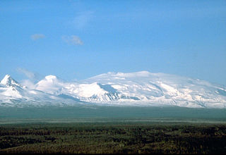
WMount Wrangell, in Ahtna K’ełt’aeni or K’ełedi when erupting, is a massive shield volcano located in Wrangell-St. Elias National Park and Preserve in southeastern Alaska, United States. The shield rises over 12,000 feet (3,700 m) above the Copper River to its southwest. Its volume is over 220 cubic miles (920 km3), making it more than twice as massive as Mount Shasta in California, the largest stratovolcano by volume in the Cascades. It is part of the Wrangell Volcanic Field, which extends for more than 250 kilometers (160 mi) across Southcentral Alaska into the Yukon Territory, and has an eruptive history spanning the time from Pleistocene to Holocene.
 W
WYucca Mountain is a mountain in Nevada, near its border with California, approximately 100 miles (160 km) northwest of Las Vegas. Located in the Great Basin, Yucca Mountain is east of the Amargosa Desert, south of the Nevada Test and Training Range and in the Nevada National Security Site. It is the site of the Yucca Mountain nuclear waste repository, which is currently identified by Congressional law as the nation's spent nuclear waste storage facility. However, while licensure of the site through the Nuclear Regulatory Commission is ongoing, political maneuvering led to the site being de-funded in 2010.