 W
WMontane grasslands and shrublands is a biome defined by the World Wildlife Fund. The biome includes high altitude grasslands and shrublands around the world. The term "montane" in the name of the biome refers to "high altitude", rather than the ecological term which denotes the region below treeline.
 W
WThe Afromontane regions are subregions of the Afrotropical realm, one of the Earth's eight biogeographic realms, covering the plant and animal species found in the mountains of Africa and the southern Arabian Peninsula. The Afromontane regions of Africa are discontinuous, separated from each other by lower-lying areas, and are sometimes referred to as the Afromontane archipelago, as their distribution is analogous to a series of sky islands.
 W
WAlpine tundra is a type of natural region or biome that does not contain trees because it is at high elevation. As the latitude of a location approaches the poles, the threshold elevation for alpine tundra gets lower until it reaches sea level, and alpine tundra merges with polar tundra.
 W
WThe Alpine-steppe is a high altitude natural alpine grassland, which is a part of the Montane grasslands and shrublands biome.
 W
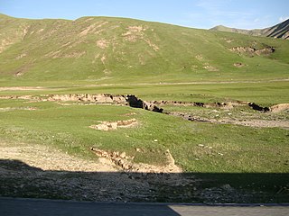
WThe Altai alpine meadow and tundra ecoregion is a terrestrial ecoregion covering the higher elevation of the Altai Mountains at the center of the "X" formed by the borders separating Russia, Kazakhstan, China, and Mongolia. The mountain peaks are the farthest north in Central Asia, separating the plains of Siberia to the north from the hot, dry deserts to the south. Altitudes above 2,400 meters display characteristics of tundra, with patches of alpine meadows and some trees immediately below the treeline. The ecoregion is in the montane grasslands and shrublands biome, and the Palearctic realm, with a humid continental climate. It covers an area of 90,132 square kilometres (34,800 sq mi).
 W
WThe Angolan montane forest-grassland mosaic ecoregion is located on the east-facing inland side of the belt of mountains that stands parallel to the coast of Angola, 50–100 km inland.
 W
WThe Angolan Scarp savanna and woodlands is an ecoregion located on the coast of Angola, an area with a variety of habitats and rich in wildlife including many endemic birds and animals.
 W
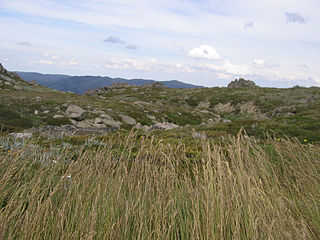
WThe Australian Alps montane grasslands is a montane grassland ecoregion of south-eastern Australia, restricted to the montane regions above 1300 metres.
 W
WThe Bogotá savanna is a montane savanna, located in the southwestern part of the Altiplano Cundiboyacense in the center of Colombia. The Bogotá savanna has an extent of 4,251.6 square kilometres (1,641.6 sq mi) and an average altitude of 2,550 metres (8,370 ft). The savanna is situated in the Eastern Ranges of the Colombian Andes.
 W
WBugyals are alpine pasture lands, or meadows, in higher elevation range between 3,300 metres (10,800 ft) and 4,000 metres (13,000 ft) of the Himalayas in the Indian state of Uttarakhand, where they are called "nature’s own gardens". The topography of the terrain is either flat or sloped. The surface of these bugyals is covered with natural green grass and seasonal flowers. They are used by tribal herdsmen to graze their cattle. During the winter season the alpine meadows remain snow-covered. During summer months, the Bugyals present a riot of beautiful flowers and grass. As bugyals constitute very fragile ecosystems, particular attention needs to be given for their conservation.
 W
WThe Caucasus-Anatolian-Hyrcanian temperate forests is a composite ecoregion of southern Europe and West Asia, designated by the World Wildlife Fund as one of their Global 200 ecoregions, a list of priority ecoregions for conservation.
 W
WThe Central Andean dry puna (NT1001) is an ecoregion in the Montane grasslands and shrublands biome, located in the Andean high plateau, in South America. It is a part of the Puna grassland.
 W
WThe New Guinea Highlands, also known as the Central Range or Central Cordillera, is a long chain of mountain ranges it is home of several highest peaks in the island of New Guinea including a 16,024 ft (4,884 m) Puncak Jaya the highest mountain in Oceania. The intermountain river valleys, many of which support thriving agricultural communities, on the large island of New Guinea. The highlands run generally east-west the length of the island, which is divided politically between Indonesia in the west and Papua New Guinea in the east.
 W
WThe Central Tibetan Plateau alpine steppe ecoregion covers the high alpine plateau that stretches over 1,600 kilometres (1,000 mi) across the Tibetan Plateau to Qinghai Lake in China. Because of the high altitude—much it over 5,000 metres (16,000 ft)—the region is a cold, arid desert that is only 20% covered with steppe and meadow vegetation. The area has been relatively free from human development due to the hostile climate and unsuitability for agriculture. The ecosystem is relatively intact, and supports herds of wild antelope, sheep, deer, and gazelles.
 W
WThe Costa Rican páramo, also known as the Talamanca páramo, is a natural region of montane grassland and shrubland of Costa Rica and western Panama.
 W
WThe Drakensberg is the name given to the eastern portion of the Great Escarpment, which encloses the central Southern African plateau. The Great Escarpment reaches its greatest elevation – 2,000 to 3,482 metres within the border region of South Africa and Lesotho.
 W
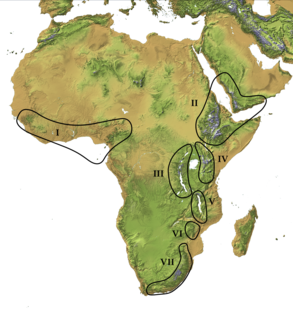
WThe East African montane moorlands is a montane grasslands and shrublands ecoregion which occupies several high mountain peaks in Kenya, South Sudan, Tanzania, and Uganda.
 W
WThe Eastern Highlands, also known as the Manica Highlands, is a mountain range on the border of Zimbabwe and Mozambique. The Eastern Highlands extend north and south for about 300 kilometres (190 mi) through Zimbabwe's Manicaland Province and Mozambique's Manica Province.
 W
WThe Eastern Himalayan alpine shrub and meadows is a montane grasslands and shrublands ecoregion of Bhutan, China, India, Myanmar, and Nepal, which lies between the tree line and snow line in the eastern portion of the Himalaya Range.
 W
WThe Ethiopian Highlands is a rugged mass of mountains in Ethiopia, situated in northeast part of Africa. It forms the largest continuous area of its elevation in the continent, with little of its surface falling below 1,500 m (4,900 ft), while the summits reach heights of up to 4,550 m (14,930 ft). It is sometimes called the Roof of Africa due to its height and large area. Most of the Ethiopian Highlands are part of central and northern Ethiopia, and its northernmost portion reaches into Eritrea.
WThe Ethiopian Highlands is a rugged mass of mountains in Ethiopia, situated in northeast part of Africa. It forms the largest continuous area of its elevation in the continent, with little of its surface falling below 1,500 m (4,900 ft), while the summits reach heights of up to 4,550 m (14,930 ft). It is sometimes called the Roof of Africa due to its height and large area. Most of the Ethiopian Highlands are part of central and northern Ethiopia, and its northernmost portion reaches into Eritrea.
WThe Ethiopian Highlands is a rugged mass of mountains in Ethiopia, situated in northeast part of Africa. It forms the largest continuous area of its elevation in the continent, with little of its surface falling below 1,500 m (4,900 ft), while the summits reach heights of up to 4,550 m (14,930 ft). It is sometimes called the Roof of Africa due to its height and large area. Most of the Ethiopian Highlands are part of central and northern Ethiopia, and its northernmost portion reaches into Eritrea.
 W
WA forest steppe is a temperate-climate ecotone and habitat type composed of grassland interspersed with areas of woodland or forest.
 W
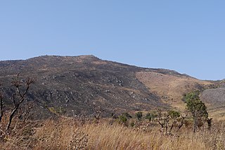
WThe Highveld is the portion of the South African inland plateau which has an altitude above roughly 1500 m, but below 2100 m, thus excluding the Lesotho mountain regions to the south-east of the Highveld. It is home to some of the country's most important commercial farming areas, as well as its largest concentration of metropolitan centres, especially the Gauteng conurbation, which accommodates one-third of South Africa's population.
 W
WThe Jos Plateau is a plateau located near the centre of Nigeria. The plateau has given its name to the Plateau State in which it is found and is itself named for the state's capital, Jos. The plateau is home to people of diverse cultures and languages. The plateau's montane grasslands, savannas, and forests are home to communities of plants and animals distinct from those of the surrounding lowlands, and constitute the Jos Plateau forest-savanna mosaic ecoregion.
WThe Karakoram-West Tibetan Plateau alpine steppe is a montane grasslands and shrublands ecoregion found in parts of Pakistan, China, Afghanistan, and India.
 W
WThe Khangai Mountains alpine meadows ecoregion runs along the central ridge of the Khangai Mountains in central Mongolia. The slopes to the north are confer forests, the lowlands to the south are semi-arid steppe. The Khangai are an "island" mountain range surrounded by lower forest steppe and semi-arid regions of central Mongolia. Most of the region is now protected by Tarvagatai Nuruu National Park and Khangai Nuruu National Park.
 W
WThe Kopet Dag woodlands and forest steppe ecoregion coincides with the Kopet Dag mountains, straddling the southern border of Turkmenistan and the northeastern border of Iran. The region is one of high biodiversity, as it includes a full range of altitude zones, and variety of habitats included juniper-wooded slopes, montane grasslands, and tugay.
 W
WThe Kuh Rud and Eastern Iran montane woodlands ecoregion covers hills and mountains in central and eastern Iran. The habitat is wetter and cooler than the surrounding desert of the Iranian Plateau, supporting the vulnerable Goitered gazelle and small populations of the vulnerable Cheetah. The ecoregion is under conservation threat from overgrazing and conversion of steep slopes to cultivation.
 W
WThe Lesotho Highlands are formed by the Drakensberg and Maloti mountain ranges in the east and central parts of the country of Lesotho. Foothills form a divide between the lowlands and the highlands. Snow is common in the highlands in the winter.
 W
WThe Madagascar ericoid thickets is a montane shrubland ecoregion, found at higher altitudes on Madagascar's four major mountains.
 W
WThe Maputaland-Pondoland bushland and thickets is one of the ecoregions of South Africa. It consists of the montane shrubland biome.
 W
WThe Mediterranean High Atlas juniper steppe is a montane grasslands and shrublands ecoregion in Morocco. It extends along the High Atlas range of northwestern Africa's Atlas Mountains.
 W
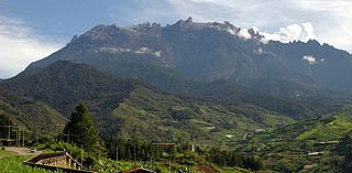
WMountain Kinabalu is a mountain located in Ranau district, West Coast Division of Sabah, Malaysia. It is protected as Kinabalu Park, a World Heritage Site. Kinabalu is the highest peak in Borneo's Crocker Range, the Malay Archipelago, and Malaysia. Mount Kinabalu is also the 20th most prominent mountain in the world by topographic prominence.
WThe New Guinea Highlands, also known as the Central Range or Central Cordillera, is a long chain of mountain ranges it is home of several highest peaks in the island of New Guinea including a 16,024 ft (4,884 m) Puncak Jaya the highest mountain in Oceania. The intermountain river valleys, many of which support thriving agricultural communities, on the large island of New Guinea. The highlands run generally east-west the length of the island, which is divided politically between Indonesia in the west and Papua New Guinea in the east.
 W
WThe North Tibetan Plateau-Kunlun Mountains alpine desert ecoregion covers a long stretch of mostly treeless alpine terrain across the northern edge of the Tibet Plateau. A variety of cold, dry habitats are found, including alpine meadows, steppe, desert, and cushion plant floral areas.
 W
WThe Northwestern Himalayan alpine shrub and meadows is a montane grasslands and shrublands ecoregion of the elevations of the northwestern Himalaya of China, India, and Pakistan.
 W
WThe Palani Hills are a mountain range in the southern Indian states of Kerala and Tamil Nadu. The Palani Hills are an eastward extension of the Western Ghats ranges, which run parallel to the west coast of India. The Palani Hills adjoin the high Anamalai range (Kerala) on the west, and extend east into the plains of Tamil Nadu, covering an area of 2,068 square kilometres (798 sq mi). The highest part of the range is in the southwest, and reaches 1,800-2,500 metres elevation; the eastern extension of the range is made up of hills 1,000-1,500 m (3,281-4,921 ft) high.
 W
WThe Pamir alpine desert and tundra ecoregion covers the high plateau of the Pamir Mountains, at the central meeting of the great mountain ranges of Central Asia: Himalaya, Karakoram, Hindu Kush, Kunlun, and Tian Shan. It is a region of relatively high biodiversity due to its central location and high elevation differentials, but it also acts as a barrier between the climate and habitats of north and south Asia.
 W
WPáramo can refer to a variety of alpine tundra ecosystems. Some ecologists describe the páramo broadly as "all high, tropical, montane vegetation above the continuous timberline". A more narrow term classifies the páramo according to its regional placement in the northern Andes of South America and adjacent southern Central America. The páramo is the ecosystem of the regions above the continuous forest line, yet below the permanent snowline. It is a "Neotropical high mountain biome with a vegetation composed mainly of giant rosette plants, shrubs and grasses". According to scientists, páramos may be "evolutionary hot spots" and among the fastest evolving regions on Earth.
 W
WThe puna grassland ecoregion, of the montane grasslands and shrublands biome, is found in the central Andes Mountains of South America. It is considered one of the eight Natural Regions in Peru, but extends south, across Bolivia, as far as northern Argentina and Chile. The term puna encompasses diverse ecosystems of the high Central Andes above 3200–3400 m.
 W
WThe Qilian Mountains subalpine meadows ecoregion covers the high meadows and shrubland of the Qilian Mountains, on the northeastern edge of the Tibetan Plateau in central China. These mountains form a divide between the dry regions of the Gobi Desert to the north, and the Qaidam Basin and the Tibetan Plateau to the south. While the habitat supports populations of marmots, grouse and some rare mammal species, the grasslands of the region are under pressure from over-grazing by domestic livestock.
 W
WThe Ruwenzori-Virunga montane moorlands is a montane grasslands and shrublands ecoregion of central Africa.
 W
WThe Santa Marta páramo (NT1007) is an ecoregion containing páramo vegetation above the treeline in the Sierra Nevada de Santa Marta mountain range on the Caribbean coast of Colombia. The isolated position of the range has allowed unique species to evolve. Some are related to those found in Central America and the Caribbean coastal areas, and some to species from the Andes. The habitat is relatively stable, but has been drastically changed from the original by long-term human activity.
 W
WThe Sayan Alpine meadows and tundra ecoregion is an ecoregion that covers the high areas of the Sayan mountains above the treeline, between the Altai Mountains in the west and Lake Baikal in the east. The area is remote and protects diverse species of alpine flora and fauna. It has an area of 846,149 square kilometres (326,700 sq mi).
 W
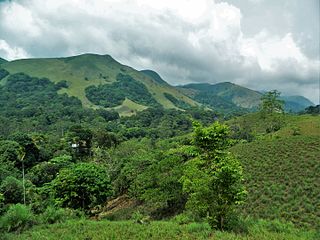
WSholas are the local name for patches of stunted tropical montane forest found in valleys amid rolling grassland in the higher montane regions of South India, largely in Kerala. These patches of shola forest are found mainly in the valleys and are usually separated from one another by undulating montane grassland. The shola and grassland together form the shola-grassland complex or mosaic. The word 'Shola' is probably derived from the Tamil language word cÕlai (சோலை) meaning grove.
 W
WThe South Malawi montane forest-grassland mosaic is an ecoregion of Malawi.
 W
WThe Southeast Tibet shrub and meadows are a montane grassland ecoregion that cover the southeast and eastern parts of the Tibetan Plateau in China. The meadows in this region of Tibet are in the path of the monsoon rains and are wetter than the other upland areas of the Tibetan Plateau. Chinese provinces covered by the Southeast Tibet shrub and meadows include the alpine parts of eastern Tibet Autonomous Region, the alpine parts of western and northern Sichuan, extreme southern and eastern Qinghai, and the montane areas of southern Gansu. Many mountain ranges support the Southeast Tibet meadows, stretching from the Nyainqêntanglha Mountains in the southwest to the Qilian Mountains in the northeast.
 W
WSouthern Afrotemperate Forest is a kind of tall, shady, multilayered indigenous South African forest. This is the main forest-type in the south-western part of South Africa, naturally extending from the Cape Peninsula in the west, as far as Port Elizabeth in the east. In this range, it usually occurs in small forest pockets, surrounded by fynbos vegetation.
 W
WThe Southern Andean steppe is a montane grasslands and shrublands ecoregion occurring along the border of Chile and Argentina in the high elevations of the southern Andes mountain range.
 W
WThe South Malawi montane forest-grassland mosaic is a montane grasslands and shrublands ecoregion of Tanzania, Malawi, Mozambique, and Zambia.
 W
WThe Southland montane grasslands, also known as the South Island montane grasslands, is a montane grasslands and shrublands ecoregion on New Zealand’s South Island. The ecoregion covers the middle portion of the Southern Alps, and includes extensive alpine grasslands, fellfields, and montane forests.
 W
WIn physical geography, a steppe is an ecoregion characterized by grassland plains without trees apart from those near rivers and lakes. Steppe biomes may include:the montane grasslands and shrublands biome the temperate grasslands, savannas and shrublands biome
 W
WDuring the Last Glacial Maximum, the mammoth steppe was the Earth’s most extensive biome. It spanned from Spain eastward across Eurasia to Canada and from the arctic islands southward to China. It had a cold, dry climate; the vegetation was dominated by palatable high-productivity grasses, herbs and willow shrubs, and the animal biomass was dominated by bison, horses, and woolly mammoth. This ecosystem covered wide areas of the northern part of the globe, thrived for approximately 100,000 years without major changes, and then suddenly became all but extinct about 12,000 years ago.
 W
WThe Sulaiman Range alpine meadows ecoregion covers a series of higher altitude mountain ranges along the crest of the Sulaiman Mountains, a southerly extension of the Hindu Kush Mountains along the Afghanistan-Pakistan border. The area is relatively undeveloped, with about a third of the terrain either forested or in 'alpine-steppe' shrub or herbaceous cover.
 W
WThe Tian Shan montane steppe and meadows ecoregion covers a 2,000 km long stretch of grasslands of the isolated Tian Sham mountains of Central Asia. It is characterized by high-altitude flat and rolling grasslands.
 W
WThe Tibetan Plateau alpine shrublands and meadows ecoregion covers the middle transition zone between the northern and southern regions of the Tibet Plateau. The region supports both cold alpine steppe and meadows across a broad expanse of the plateau. Wild deer, antelope, and sheep roam the grasslands, but the habitat is increasingly being used to graze domestic livestock.
 W
WThe Western Himalayan alpine shrub and meadows is a montane grasslands and shrublands ecoregion of Nepal, India, and Tibet, which lies between the tree line and snow line in the western portion of the Himalaya Range.
 W
WThe Zacatonal is a montane grassland and shrubland ecoregion of central Mexico, and Guatemala. The term is also used to refer to montane grasslands.