 W
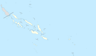
WThis is a list of islands of Solomon Islands, by province and archipelago.
 W
WThe Solomon Islands are an archipelago in the western South Pacific Ocean, located northeast of Australia. They are in the Melanesia subregion and bioregion of Oceania. The archipelago forms much of the territory of Solomon Islands, while the northwestern islands are within the Autonomous Region of Bougainville, in eastern Papua New Guinea. It forms the eastern boundary of the Solomon Sea.
 W
WAeaun is a small island in the Russell Islands, Solomon Islands; it is located in the Central Province. It is the northernmost islet of the Russel Islands, located on the coral reef north of the group's main island Pavuvu.
 W
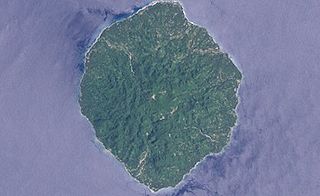
WAnuta is a small high island in the southeastern part of the Solomon Islands province of Temotu, one of the smallest permanently inhabited Polynesian islands. It is one of the Polynesian Outlier communities in Melanesia.
 W
WArundel Island is an island of the New Georgia Islands archipelago in the Western Province of Solomon Islands. Its indigenous names are Kohinggo and Ndokulu.
 W
WAvaiki is one of the many names by which the peoples of Polynesia refer to their ancestral and spiritual homelands.
WBalalae Island is an island of the Shortland Islands Group in the Western Province of the Solomon Islands.
 W
WChoiseul Island, native name Lauru, is the largest island of the Choiseul Province, Solomon Islands, at 7.08°S 157°E. The administrative headquarters of Choiseul Province is situated in the town of Taro.
 W
WThe Duff Islands are a small island group lying to the northeast of the Santa Cruz Islands in the Solomon Islands province of Temotu. They are also sometimes known as the Wilson Islands.
 W
WFatutaka, Fatu Taka or Patu Taka is a small high island in the Solomon Islands province of Temotu in the south-west Pacific Ocean. The easternmost of the Solomon Islands, Fatutaka is located c. 32 km (20 mi) southeast of Anuta and can be seen from there in clear weather. Fatutaka and Anuta were discovered by Admiral Edward Edwards in 1791.
 W
WFauro Island is an island of the Shortland Islands archipelago, located in the Western Province of the Solomon Islands, located at 6°55′S 156°4′E. Along the center spine of the island are Mount Pauboleala with an elevation of 574 metres, Mount Lalauka with an elevation of 517 m, and Sharp Peak with an elevation of 484 m.
WGavutu is a small islet in the Central Province of the Solomon Islands, some 500 metres in length. It is one of the Nggela Islands.
WGhizo Island, home to Gizo, the capital of the Western Province, Solomon Islands. The island is named after an infamous local head-hunter. It is located west of New Georgia and Kolombangara.
 W
WGuadalcanal is the principal island in Guadalcanal Province of the Solomon Islands, located in the south-western Pacific, northeast of Australia. It is the largest island in the Solomon Islands by area, and the second by population. The island is mainly covered in dense tropical rainforest and has a mountainous interior.
 W
WKennedy Island is a small uninhabited island in the Solomon Islands that was named after John F. Kennedy, following an incident involving Kennedy during his World War II naval career. Kennedy Island lies 15 minutes by boat from Gizo, the provincial capital of the Solomon Islands' Western Province.
 W
WKolombangara is an island in the New Georgia Islands group of the nation state of Solomon Islands in the southwestern Pacific Ocean. The name is from a local language, a rough translation of its meaning is "Water Lord" with approximately 80 rivers and streams running down its flanks.
 W
WLanga Langa Lagoon or Akwalaafu is a natural lagoon on the West coast of Malaita near the provincial capital Auki within the Solomon Islands. The lagoon is 21 km in length and just under 1 km wide. The "lagoon people" or "salt water people" live on small artificial islands built up on sand bars over time where they were forced to flee from the headhunters of mainland Malaita.
 W
WLaulasi island is an artificial island in the Langa Langa Lagoon, South of Auki on the island of Malaita in the Solomon Islands. It is believed that hostilities among the inlanders of Malaita forced some people into the lagoon where over time they built their islands on sandbars after diving for coral. The religion of the island was based on prayers and offerings to the ghosts of dead ancestors, mediated by priests who kept their skulls and relics in tabu houses. Some ancestors were incarnated as sharks which protected their descendants. Langalanga is also the main source of the shell money now made in Solomon Islands.
 W
WThe island of Makira is the largest island of Makira-Ulawa Province in the Solomon Islands. The island is located east of Guadalcanal and south of Malaita. The largest and capital city is Kirakira.
 W
WMalaita is the primary island of Malaita Province in Solomon Islands. Malaita is the most populous island of the Solomon Islands, with a population of 140,000, or more than a third of the entire national population. It is also the second largest island in the country by area, after Guadalcanal. A tropical and mountainous island, Malaita's pristine river systems and tropical forests have not been exploited.
WMbanika or Banika is an island in Solomon Islands; it is located in the Central Province and is the second largest of the Russell Islands Group. The principal settlement is Yandina.
 W
WMbava is an island in the Solomon Islands;.
 W
WNendö [neⁿdɵ] is the largest of the Santa Cruz Islands, located in the Temotu province of Solomon Islands. The island is also known as Santa Cruz, Nendo, Ndeni, Nitendi or Ndende. The name Santa Cruz was given to the island in 1595 by the Spanish navigator Álvaro de Mendaña, who started a colony there.
 W
WNew Georgia, with an area of 2,037 km2, is the largest of the islands in Western Province, Solomon Islands, and the 200th-largest island in the world.
WThe New Georgia Islands are part of the Western Province of Solomon Islands. They are located to the northwest of Guadalcanal. The larger islands are mountainous and covered in rain forest. The main islands are New Georgia, Vella Lavella, Kolombangara, Ghizo, Vangunu, Rendova and Tetepare. They are surrounded by coral reefs and includes the largest salt water lagoon in the world: Marovo lagoon.
WNggatokae Island is an island in the New Georgia Islands within Western Province, Solomon Islands. It is served by Gatokae Aerodrome.
 W
WThe Nggela Islands, also known as the Florida Islands, are a small island group in the Central Province of Solomon Islands, a sovereign state in the southwest Pacific Ocean.
WNuatambu was an island in the Solomon Islands; it was located in Choiseul Province. Nuatambu was home to 25 families before it sank.
 W
WNukapu is one of the islands of the nation of Solomon Islands. It is in the Reef Islands group in Temotu Province; the easternmost province of the Solomons. The estimated terrain elevation above sea level is 15 metres.
WOwaraha or Owa Raha is an island in the Solomon Islands; it is located in Makira-Ulawa Province.
WOwariki or Owa Riki is an island in Solomon Islands; it is located in Makira-Ulawa Province.
WPavuvu is the largest of the Russell Islands in Central Province, Solomon Islands. It is located northwest of Guadalcanal. The area is 129.19 square kilometres (49.88 sq mi). The largest village is Nukufero on the north coast.
 W
WPileni is a culturally important island in the Reef Islands, in the northern part of the Solomon Islands province of Temotu. Despite its location in Melanesia, the population of the islands is Polynesian.
 W
WPio Island is an island in the Solomon Islands province of Makira-Ulawa. It is situated 4 km north-west of Ugi Island. It is 2.7 km long and 1.5 km wide. The estimated terrain elevation above sea level is some 227 metres. The island has no villages. Coral reef surrounds the island, which is largest in the west and south of the island.
WRamata Island is a small island about 4 kilometres (2.5 mi) long and less than 500 metres (1,600 ft) wide lying just off the New Georgia in the Solomon Islands.
 W
WRanongga is an island located in the New Georgia Islands group of Western Province, Solomon Islands.
WThe Reef Islands are a loose collection of 16 islands in the northwestern part of the Solomon Islands province of Temotu. These islands have historically also been known by the names of Swallow Islands and Matema Islands.
 W
WRendova is an island in the Western Province of the Solomon Islands in the South Pacific, east of Papua New Guinea.
 W
WRob Roy Island, native name Velaviru, is an island in the Solomon Islands located off the South East coast of Choiseul Island; it is located in Choiseul Province.
 W
WThe Russell Islands are two small islands, as well as several islets, of volcanic origin, in the Central Province of Solomon Islands. They are located approximately 48 kilometres northwest of Guadalcanal. The islands are partially covered in coconut plantations, and have a copra and oil factory at Yandina. Yandina also has basic services, including a store, post office, and airport.
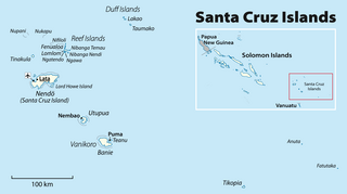
WThe Santa Cruz Islands are a group of islands in the Pacific Ocean, part of Temotu Province of the nation of Solomon Islands. They lie approximately 250 miles (400 km) to the southeast of the Solomon Islands archipelago. The Santa Cruz Islands lie just north of the archipelago of Vanuatu, and are considered part of the Vanuatu rain forests ecoregion.
 W
WSanta Isabel Island is the longest in Solomon Islands, the third largest in terms of surface area, and the largest in the group of islands in Isabel Province.
 W
WSavo Island is an island in Solomon Islands in the southwest South Pacific ocean. Administratively, Savo Island is a part of the Central Province of the Solomon Islands. It is about 35 km from the capital Honiara. The principal village is Alialia, in the north of the island.
 W
WShortland Island is the largest island of the Shortland Islands archipelago, in the Western Province of the Solomon Islands, at 7°3′S 155°45′E.
WSouth Malaita Island, also known as Small Malaita and Maramasike for Areare speakers and Malamweimwei known to more than 80% of the islanders, is the island at the southern tip of the larger island of Malaita in the eastern part of the Solomon Islands. It is called "small" to distinguish it from the much larger mainland. It is now part of Malaita Province. South Malaita came under effective control of the colonial administration after the Solomon Islands was declared a British Protectorate in 1893. The administration included the collection of taxes from the islanders. During the colonial days, the island was divided by the colonial government and missionary establishments into the Asimeuri, Asimae, and Raroisu'u districts. Away from Malaita, most people from "Small" or "South" Malaita usually just say the word "South", everyone knows what they mean.
 W
WTanambogo is an islet in the Central Province of the Solomon Islands. It is one of the Florida Islands.
WTaro Island is a small island in Solomon Islands with 507 inhabitants. It is the capital of Choiseul Province and is located in Choiseul Bay off the northwest coast.
 W
WTaumako is the largest of the Duff Islands, in the Solomon Islands. This 5.7-kilometre-long (3.5-mile) island has steep sides and rises to a height of 400 metres above sea level. It is composed of basaltic lavas and pyroclastics like the other islands in the Duffs.
 W
WTetepare Island is the largest uninhabited island in the South Pacific, located at 8.716667°S 157.55°E. It is a part of Western Province of the Solomon Islands. It covers approximately 118 square kilometres. Tetepare supports pristine lowland rainforest and a rich inshore marine area. The meaning of the name is uncertain; it most probably means "wild pig" or "fighting boar" because the island was famous for these animals among inhabitants of the region.
 W
WTikopia is a high island in the southwestern Pacific Ocean. It is part of the Solomon Islands of Melanesia, but is culturally Polynesian. The first Europeans arrived on 22 April 1606 as part of the Spanish expedition of Pedro Fernandes de Queirós.
 W
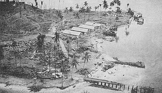
WTulagi, less commonly known as Tulaghi, is a small island — 5.5 by 1 kilometre, area 2.08 square kilometres (0.80 sq mi) — in the Solomon Islands, just off the south coast of Ngella Sule. The town of the same name on the island was the capital of the British Solomon Islands Protectorate from 1896 to 1942 and is today the capital of the Central Province. The capital of what is now the state of Solomon Islands moved to Honiara, Guadalcanal, after World War II.
 W
WUepi is an island located in the Western Province of the Solomon Islands (nation). It is noted for its high quality blue-water drop-off scuba diving.
WUgi Island, also Uki Island, is an island in Solomon Islands; it is located in Makira-Ulawa Province and lies 11 km north of Makira Island.
WUlawa Island is an island in the Solomon Islands. It is located near Malaita Island and belongs to Makira Ulawa Province. The island has an area of 65.92 square kilometres.
WUtupua Island is an island in the Santa Cruz Islands, located 66 km to the Southeast of the main Santa Cruz group, between Vanikoro and Santa Cruz proper. This island belongs administratively to the Temotu Province of the Solomon Islands.
 W
WVangunu is an island, part of the New Georgia Islands in the Solomon Islands. It is located between New Georgia and Nggatokae Island. To the north and east of the island is Marovo Lagoon. The island has an area of 509 square kilometres.
 W
WVanikoro is an island in the Santa Cruz group, located 118 kilometres to the Southeast of the main Santa Cruz group. It is part of the Temotu Province of the Solomon Islands.
 W
WVella Lavella is an island in the Western Province of the Solomon Islands. It lies to the west of New Georgia, but is considered one of the New Georgia Group. To its west are the Treasury Islands.
WWagina Island is a small island in the country of Solomon Islands. The easiest way to reach Wagina is by plane to Kaghau Airport, Choiseul Province, from Honiara. From Kagau it takes only 45 – 60 minutes by OBM to Wagina.