 W
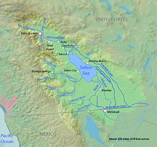
WThe Imperial Valley lies in the California counties of Imperial and Riverside in southeastern Southern California with an urban area centered on the city of El Centro. The Valley is bordered by the Colorado River to the east and, in part, the Salton Sea to the west. Farther west lies the San Diego and Imperial County border. To the north is the Coachella Valley region of Riverside County, which together with Imperial Valley form the Salton Trough, or the Cahuilla Basin, also the county line of Imperial and Riverside counties, and to the south the international boundary with the U.S. state of California and Baja California.
 W
WThe 1981 Westmorland earthquake occurred at 05:31 Pacific Daylight Time on April 26. The moderate strike-slip shock took place in the Imperial Valley of Southern California, just north of the Mexico–United States border in the United States. No injuries or deaths occurred, but damage was estimated at $1–3 million. With a Mercalli intensity of VII, this was one of fifteen intensity VII or greater shocks in the Imperial Valley that were observed in the 20th century up until April 1981. The region experiences large stand-alone events and earthquake swarms due to its position in an area of complex conditions where faulting transitions from strike-slip movement to the north and divergence to the south.
WThe 1987 Superstition Hills earthquakes were a pair of earthquakes Mw 6.2 and 6.6 that rattled the Imperial Valley of California. The earthquakes caused damage to places in California and Mexico, and was felt as far as Las Vegas and Phoenix. Both main shocks were larger than the deadly earthquake that struck Los Angeles on October 1, which was a magnitude 5.9.
 W
WThe Alamo Canal was a 14 mi (23 km) long waterway that connected the Colorado River to the head of the Alamo River. The canal was constructed to provide irrigation to the Imperial Valley. A small portion of the canal was located in the United States but the majority of the canal was located in Mexico. The Alamo Canal is also known as the Imperial Canal.
 W
WThe Alamo River flows west and north from the Mexicali Valley across the Imperial Valley (California). The 52-mile-long (84 km) river drains into the Salton Sea.
 W
WAlamorio is an unincorporated community in Imperial County, California. It is located 12.5 miles (20 km), north-northwest of Holtville, at an elevation of 128 feet below sea level. The community resides along the Alamo River, and was named by combining the Spanish words alamo, and rio.
 W
WThe Algodones Dunes is a large erg located in the southeastern portion of the U.S. state of California, near the border with Arizona and the Mexican state of Baja California. The field is approximately 45 miles (72 km) long by 6 miles (9.7 km) wide and extends along a northwest-southeast line that correlates to the prevailing northerly and westerly wind directions. The name "Algodones Dunes" refers to the entire geographic feature, while the administrative designation for that portion managed by the Bureau of Land Management is the Imperial Sand Dunes Recreation Area. In 1966, Imperial Sand Hills was designated as a National Natural Landmark by the National Park Service. The Algodones Dunes are split into many different sections. These sections include Glamis, Gordon's Well, Buttercup, Midway, and Patton's Valley. Although the Arabic-derived Spanish word algodones translates to "cotton plants", the origin of the toponym is unknown.
 W
WThe All-American Canal is an 80-mile (130 km) long aqueduct, located in southeastern California. It conveys water from the Colorado River into the Imperial Valley and to nine cities. It is the Imperial Valley's only water source, and replaced the Alamo Canal, which was located mostly in Mexico. The Imperial Dam, about 30 miles (48 km) northeast of Yuma, Arizona on the Colorado River, diverts water into the All-American Canal, which runs to just west of Calexico, California before its last branch heads mostly north into the Imperial Valley. Five smaller canals branching off the All American Canal move water into the Imperial Valley. These canal systems irrigate up to 630,000 acres (250,000 ha) of crop land and have made possible a greatly increased crop yield in this area, originally one of the driest on earth. It is the largest irrigation canal in the world, carrying a maximum of 26,155 cubic feet per second (740.6 m3/s). Agricultural runoff from the All American Canal drains into the Salton Sea.
 W
WThe Andrade Port of Entry is the easternmost and lowest volume border crossing in California, USA. It is located 2 miles south of Interstate 8, and about 2000 feet west of the Colorado River, in Imperial County opposite the Los Algodones border crossing in Baja California, Mexico. It is a minor port in comparison to the larger Calexico West and Calexico East Ports of Entry. In spite of its remote desert location, it supports significant tourist traffic volume. The Andrade-Los Algodones border crossing is also Mexico's northernmost port of entry. The port ranked 11th for pedestrian crossings in 2010, with more than one million people processed by U.S. Customs and Border Protection.
 W
WBonds Corner is an unincorporated community in Imperial County, California a short distance east of El Centro and north of the international border with Baja California. A United States port of entry for trucks entering and exiting the country is located along nearby California State Route 7. Bonds Corner is located 9 miles (14 km) east of Calexico, at an elevation of 33 feet.
 W
WBrawley is a city in the Imperial Valley and within Imperial County, southern California, United States.
 W
WCalexico is a city in southern Imperial County, California. Situated on the Mexico–United States border, it is linked economically with the much larger city of Mexicali, the capital of the Mexican state of Baja California. It is about 122 miles (196 km) east of San Diego and 62 miles (100 km) west of Yuma, Arizona. Calexico, along with six other incorporated Imperial County cities, forms part of the larger populated area known as the Imperial Valley.
 W
WState Route 86 is a north–south state highway in the U.S. State of California that connects the Imperial and Coachella valleys in the southeastern desert region of the state. It runs from State Route 111 near the Mexican border crossing at Calexico north through the Imperial Valley via El Centro and Brawley, and around the west side of the Salton Sea into the Coachella Valley. It then goes through Coachella before terminating at Interstate 10 in Indio.
 W
WState Route 111 is a state highway in the U.S. state of California. It is the main north-south route and retail corridor through the Coachella Valley, a part of the Colorado Desert in the southeastern corner of the state and a famous resort destination. It also runs through the Imperial Valley, and along the eastern shore of the Salton Sea. Its southern terminus is at the U.S.–Mexico border crossing in Calexico, and its northern terminus is at Interstate 10 at Whitewater.
 W
WCalifornia's 40th State Senate district is one of 40 California State Senate districts. It is currently represented by Democrat Ben Hueso of San Diego.
 W
WCalifornia's 51st congressional district is a congressional district in the U.S. state of California. The district is currently represented by Democrat Juan Vargas.
 W
WCalifornia's 56th State Assembly district is one of 80 California State Assembly districts. It is currently represented by Democrat Eduardo Garcia of Coachella.
 W
WCalipatria is a city in Imperial County, California. Calipatria is located 23 miles (37 km) north of El Centro. It is part of the El Centro Metropolitan Area. The population was 7,710 at the 2010 census, up from 7,289 at the 2000 census, including 4000 inmates at Calipatria State Prison. The community is located along State Route 111.
 W
WCamp Seeley' was a US Army World War 2 training camp near El Centro, California in the Imperial Valley. At Camp Seeley was: the Camp Seeley Combat Firing Range, Camp Seeley Ordnance Desert Proving Ground and Camp Seeley Ordnance Training Center. The 17,574 acres Camp Seeley was 10 miles northwest of the City of El Centro, near the city of Seeley, California. The town is named after Henry Seeley, a pioneer of the Imperial Valley. The camp was north of what is now California State Route 98. The tent camp, in the Yuha Desert, opened November 1940, first based at the camp was the 11th Cavalry Regiment, the troops and Army horse came from the Presidio of Monterey, California. At the camp the 11th Cavalry Regiment took part in desert training and teaching horses to swim across rivers with rider. 11th Cavalry Regiment moved to Camp Lockett at Campo, California in December 1941. The 11th and 28th Cavalry Regiment also trained at the camp, along with the 75th Horse Field Artillery Battalion. In 1942 Camp Seeley was converted to a US Army ordnance proving ground. While the camp is closed the area of Camp Seeley the home of the Historical "The Colonel's Own." 11th Cavalry Horse Honor Guard.
 W
WCitrus View is an unincorporated community in Imperial County, California.
WThe Coachella Canal is a 122-mile (196 km) aqueduct that conveys Colorado River water for irrigation northwest from the All-American Canal to the Coachella Valley north of the Salton Sea in Riverside County, California.
 W
WCalifornia's Colorado Desert is a part of the larger Sonoran Desert. It encompasses approximately 7 million acres, including the heavily irrigated Coachella and Imperial valleys. It is home to many unique flora and fauna.
WCurlew is an unincorporated community in Imperial County, California. It is located on a former branch of the Southern Pacific Railroad 8.5 miles (14 km) north of Holtville, at an elevation of 89 feet below sea level.
WDate City is an unincorporated community in Imperial County, California. It is located 4.25 miles (6.8 km) east-southeast of Holtville.
WDixieland is an unincorporated community in Imperial County, California. It is located 5 miles (8 km) east of Plaster City, at an elevation of 36 feet below sea level.
WThe 1940 El Centro earthquake occurred at 21:35 Pacific Standard Time on May 18 in the Imperial Valley in southeastern Southern California near the international border of the United States and Mexico. It had a moment magnitude of 6.9 and a maximum perceived intensity of X (Extreme) on the Mercalli intensity scale. It was the first major earthquake to be recorded by a strong-motion seismograph located next to a fault rupture. The earthquake was characterized as a typical moderate-sized destructive event with a complex energy release signature. It was the strongest recorded earthquake to hit the Imperial Valley, and caused widespread damage to irrigation systems and led to the deaths of nine people.
WThe 1979 Imperial Valley earthquake occurred at 16:16 Pacific Daylight Time on 15 October just south of the Mexico–United States border. It affected Imperial Valley in Southern California and Mexicali Valley in northern Baja California. The earthquake had a relatively shallow hypocenter and caused property damage in the United States estimated at US$30 million. The irrigation systems in the Imperial Valley were badly affected, but no deaths occurred. It was the largest earthquake to occur in the contiguous United States since the 1971 San Fernando earthquake eight years earlier.
WEdgar is an unincorporated community in Imperial County, California. It is located on the San Diego and Arizona Eastern Railway 10 miles (16 km) west of El Centro, at an elevation of 39 feet below sea level.
 W
WImperial County is a county in the U.S. state of California. As of the 2010 census, the population was 174,528, making it the least populous county in Southern California. The county seat is El Centro. Established in 1907 from a division of San Diego County, it was the last county to be formed in California.
 W
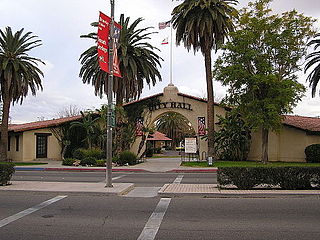
WEl Centro is a city in and county seat of Imperial County, California, United States. El Centro is the largest city in the Imperial Valley, the east anchor of the Southern California Border Region, and the core urban area and principal city of the El Centro metropolitan area which encompasses all of Imperial County. El Centro is also the largest American city to lie entirely below sea level. The city, located in southeastern California, is 113 miles (182 km) from San Diego and less than 20 miles (32 km) from the Mexican city of Mexicali.
WEstelle is an unincorporated community in Imperial County, California. This was a drop off location for rail road workers and farm laborers sometime after 1907. The location consist of a large water tower, there are two intact buildings on the property and the remains of other structures, including an area where clothing used to be washed and hung to dry. One of the structures was burned down in the year of approx 2010. This lot is now usually vacant or used to store hay. It is located on the Southern Pacific Railroad 3.5 miles (5.6 km) north of Calipatria, at an elevation of 177 feet below sea level.
WFondo is an unincorporated community in Imperial County, California. It is located on the Southern Pacific Railroad 6.5 miles (10 km) west of Calipatria, at an elevation of 203 feet below sea level.
WFuller is an unincorporated community in Imperial County, California. It is located on a former branch of the Southern Pacific Railroad 3.5 miles (5.6 km) north-northwest of Holtville, at an elevation of 69 feet below sea level.
 W
WHeber is a census-designated place (CDP) in Imperial County, California. Heber is located 4.5 miles (7 km) north-northwest of Calexico. The population was 4,275 at the 2010 census, up from 2,566 in 2000.
 W
WHoltville is a city in Imperial County, California. Holtville is located 10.5 miles (17 km) east of El Centro. The population was 5,939 at the 2010 census, up from 5,612 in 2000.
WHovley is an unincorporated community in Imperial County, California. It is located on the Southern Pacific Railroad 8.5 miles (14 km) south of Calipatria, at an elevation of 138 feet below sea level.
WImperial County is a county in the U.S. state of California. As of the 2010 census, the population was 174,528, making it the least populous county in Southern California. The county seat is El Centro. Established in 1907 from a division of San Diego County, it was the last county to be formed in California.
 W
WThe Imperial Fault Zone is a system of geological faults located in Imperial County in the Southern California region, and adjacent Baja California state in Mexico. It cuts across the border between the United States and Mexico.
 W
WImperial Valley College is a college in Imperial County, California, United States. Founded in 1962 the college currently enrolls around 7,000 students per year. Currently, Martha Garcia is President of the college. The main campus is located on a 160-acre (0.65 km2) site in the city of Imperial. The extended campuses are located in El Centro and Brawley.
 W
WImperial is a city in Imperial County, California. Imperial is located 4 miles (6.4 km) north of El Centro.
 W
WLake Cahuilla was a prehistoric lake in California and northern Mexico. Located in the Coachella and Imperial Valleys, it covered surface areas of 5,700 square kilometres (2,200 sq mi) to a height of 12 metres (39 ft) above sea level during the Holocene. During earlier stages of the Pleistocene, the lake reached even higher levels, up to 31–52 metres (102–171 ft) above sea level. During the Holocene most of the water came from the Colorado River with little contribution from local runoff; in the Pleistocene local runoff was higher and it is possible that Lake Cahuilla was supported solely from local water sources during the Wisconsin glaciation. The lake overflowed close to Cerro Prieto into the Rio Hardy, eventually draining into the Gulf of California.
 W
WThe Low Desert is a common name for any desert in California that is under 2,000 feet (609.6m) in altitude. These areas include, but are not exclusive to, the Colorado Desert and Yuha Desert, in the Southern California portion of the Sonoran Desert. These areas are distinguished in biogeography from the adjacent northern High Desert or Mojave Desert by latitude, elevation, animal life, climate, and native plant communities.
WMoss is an unincorporated community in Imperial County, California. It is located on a former branch of the Southern Pacific Railroad 13 miles (21 km) north of Holtville, at an elevation of 98 feet below sea level.
WMount Signal is an unincorporated community located along State Route 98 about 7.5 miles (12.1 km) west of Calexico in the southern part of the Imperial Valley in Imperial County, California. The area is south of Interstate 8 and about 1.7 miles (2.7 km) north of the Mexico border. It lies at an elevation of 13 feet below sea level. This is an agricultural area. There are a few homes and businesses and many irrigation canals and green fields. The Centinela Solar Energy Project is located here. Other nearby communities include Heber, El Centro, and Seeley.
 W
WThe New River flows north from near Cerro Prieto, through the city of Mexicali, Baja California, Mexico, into the United States through the city of Calexico, California, towards the Salton Sea. The river channel has existed since pre-historic times. However, the river as known today formed from a levee failure and massive flooding that re-created the Salton Sea.
 W
WNiland is a census-designated place (CDP) in Imperial County, California, United States. The town is located 8 miles (13 km) north of Calipatria, 2 miles (3.2 km) southeast of the Salton Sea. The population was 1,006 at the 2010 census, down from 1,143 in 2000. By June 2020, however, after a major fire, the estimated population had diminished to 500. It is part of the El Centro, California Metropolitan Statistical Area.
WRico is an unincorporated community in Imperial County, California. It is located on the Holton Interurban Railroad 1.25 miles (2 km) west-southwest of Holtville, at an elevation of 20 feet below sea level.
WRockwood is an unincorporated community in Imperial County, California. It is located on the Southern Pacific Railroad 5.25 miles (8.4 km) south of Calipatria, at an elevation of 154 feet below sea level.
 W
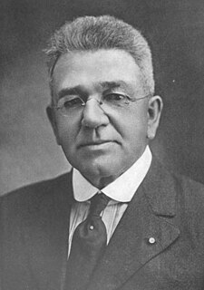
WCharles Robinson Rockwood was a United States of America citizen who worked as a surveyor, civil engineer, and entrepreneur. His most significant achievement was managing the construction of a canal system that transformed the Colorado Desert into a verdant agricultural development known as the Imperial Valley, CA, USA. He is also infamous for directing modifications to that same canal system which lead to the accidental creation of the Salton Sea in southern California, USA.
WSalton City is a census-designated place (CDP) in Imperial County, California. It is the largest Imperial County development on the Salton Sea coast. It is part of the El Centro, California Metropolitan Statistical Area. The population was 3,763 at the 2010 census, up from 978 in 2000. The population estimate for 2020 was 5,611.
 W
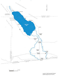
WThe Salton Sea is a shallow, saline, endorheic rift lake on the San Andreas Fault at the southern end of the U.S. state of California. It lies between, and within, the Imperial and Coachella valleys, all of which lie within the larger Salton Trough, a pull-apart basin that stretches to the Gulf of California in Mexico. The lake occupies the lowest elevations of the trough, known as the Salton Sink, where the lake surface is 236.0 ft (71.9 m) below sea level as of January 2018. The deepest point of the lake is only 5 ft (1.5 m) higher than the lowest point of Death Valley. The New, Whitewater, and Alamo rivers, combined with agricultural runoff, are the primary sources that feed the lake.
WSalton Sea Beach is a census-designated place (CDP) in Imperial County, California, located 2.5 miles (4 km) southeast of Desert Shores. The population was 422 at the 2010 census, up from 392 at the 2000 census. It is part of the El Centro, California Metropolitan Statistical Area. It was the location of the Naval Auxiliary Air Station Salton Sea.
 W
WThe Salton Sink is the low point of an Endorheic basin, a closed drainage system with no outflows to other bodies of water, in the Colorado Desert sub region of the Sonoran Desert. The sink falls within the larger Salton Trough and separates the Coachella Valley from the Imperial Valley, which are also segments of the Salton Trough. The lowest point of the sink is 269 ft (82 m) below sea level, and since 1906 the 343 square miles (890 km2) Salton Sea has filled the lowest portion of the sink to a water depth of up to 43 ft (13 m).
WSandia is an unincorporated community in Imperial County, California. It is located on a former branch of the Southern Pacific Railroad 5.25 miles (8.4 km) north-northwest of Holtville, at an elevation of 82 feet below sea level.
 W
WSeeley is a census-designated place (CDP) in Imperial County, California. Seeley is located 7.5 miles (12 km) west of El Centro. The population was 1,823 at the 2010 census, up from 1,624 in 2000. It is part of the El Centro Metropolitan Area.
WWiest is an unincorporated community in Imperial County, California. It is located 6 miles (9.7 km) southeast of Calipatria, at an elevation of 135 feet below sea level.
WWilsie is an unincorporated community in Imperial County, California. It is located on the San Diego and Arizona Eastern Railway 2.5 miles (4 km) west-northwest of El Centro, at an elevation of 33 feet below sea level.
 W
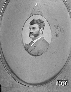
WOliver M. Wozencraft was a prominent early American settler in California. He had substantial involvement in negotiating treaties between California Native American Indian tribes and the United States of America. Later, Wozencraft promoted a plan to provide irrigation to the Imperial Valley.