 W
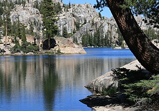
WThe Ansel Adams Wilderness is a wilderness area in the Sierra Nevada of California, USA. The wilderness spans 231,533 acres (93,698 ha): 33.9% of which is in the Inyo National Forest, 65.8% is in the Sierra National Forest, and the remaining 0.3% covers nearly all of Devils Postpile National Monument. Yosemite National Park lies to the north and northwest, while the John Muir Wilderness lies to the south.
 W
WThe Bitter Creek National Wildlife Refuge is located in the foothills of the southwestern San Joaquin Valley in Kern County, California. The refuge is one of four units of the Hopper Mountain National Wildlife Refuge Complex for California condors.
 W
WBlue Ridge National Wildlife Refuge is located in the Sierra Nevada, in Tulare County, California. The refuge is one of four units of the Hopper Mountain National Wildlife Refuge Complex for California condors.
WBright Star Wilderness is a 8,190-acre (3,314 ha) wilderness area in Kern County in the U.S. state of California.
 W
WThe Bucks Lake Wilderness is a 23,958-acre (97.0 km2) wilderness area located in the Plumas National Forest section of the Sierra Nevada, in northeastern California, United States.
 W
WButterfly Valley Botanical Area, in the northern Sierra Nevada, was designated a protected botanical area in 1976 due to its abundance and diversity of plant life. It is located just north of Quincy, in Plumas County of northeastern California, United States. The diverse and unique plant community habitats in the nature reserve, at elevations of 3,590–3,800 feet (1,090–1,160 m), are protected and managed by the Mt. Hough Ranger District of the Plumas National Forest.
 W
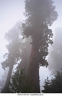
WCalaveras Big Trees State Park is a state park of California, United States, preserving two groves of giant sequoia trees. It is located 4 miles (6.4 km) northeast of Arnold, California in the middle elevations of the Sierra Nevada. It has been a major tourist attraction since 1852, when the existence of the trees was first widely reported, and is considered the longest continuously operated tourist facility in California.
 W
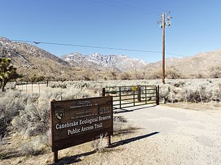
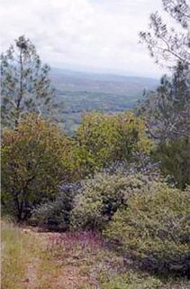
WCanebrake Ecological Reserve is a 6,700-acre (27 km2) nature reserve in the South Fork Valley of Kern County, 20 miles (32 km) east of Lake Isabella, California. It is located in the Southern Sierra Nevada region.
 W
WThe Carson–Iceberg Wilderness is a federal wilderness area located 80 miles (130 km) northeast of Stockton, California. It encompasses 160,000 acres (650 km2) and was designated by the California Wilderness Act of 1984. It protects an area of High Sierra landscape with elevations from 4,800 feet (1,500 m) to 11,462 feet (3,494 m) along the Sierra Mountains from Ebbetts Pass to Sonora Pass in the south. The US Forest Service manages the wilderness which is in both the Stanislaus National Forest and the Humboldt–Toiyabe National Forest.
WThe Chimney Peak Wilderness is a 13,134-acre (53.15 km2) wilderness area located 20 miles (32 km) northwest of Ridgecrest, in southeastern Tulare County, California.
 W
WD. L. Bliss State Park is a state park of California in the United States. It is located on the western shore of Lake Tahoe just north of Emerald Bay State Park.
 W
WThe Dardanelles and Freel Roadless Areas are located 7 miles (11 km) and 3 miles (4.8 km), respectively, south of Lake Tahoe, California, and both are managed by the Lake Tahoe Basin Management Unit of the US Forest Service.These areas are contiguous, separated only by the corridor of highway 89. The historic Hawley Grade, an immigrant wagon road, now a hiking trail, is within the Dardanelles Roadless Area, as well as the watershed of Lake Tahoe's largest inflow, the Upper Truckee River.
 W
WThe Desolation Wilderness is a 63,960-acre (258.8 km2) federally protected wilderness area in the Eldorado National Forest and Lake Tahoe Basin Management Unit, in El Dorado County, California. The crest of the Sierra Nevada runs through it, just west of Lake Tahoe.
 W
WDevils Postpile National Monument is a National Monument located near Mammoth Mountain in eastern California. The monument protects Devils Postpile, an unusual rock formation of columnar basalt. It encompasses 798 acres (323 ha) and includes two main tourist attractions: the Devils Postpile formation and Rainbow Falls, a waterfall on the Middle Fork of the San Joaquin River. In addition, the John Muir Trail and Pacific Crest Trail merge into one trail as they pass through the monument. Excluding a small developed area containing the monument headquarters, visitor center and a campground, the National Monument lies within the borders of the Ansel Adams Wilderness.
WThe Dinkey Lakes Wilderness is a federally designated wilderness area located 45 miles (72 km) northeast of Fresno, in the state of California, USA. It comprises 30,000 acres (12,141 ha) within the Sierra National Forest and was added to the National Wilderness Preservation System by the California Wilderness Act of 1984.
 W
WThe Domeland Wilderness is a federally designated wilderness area located 55 miles (89 km) northeast of Bakersfield, California USA. It encompasses 130,081 acres (526.42 km2), is jointly managed by the U.S. Forest Service and Bureau of Land Management (BLM) and is mostly within the Sequoia National Forest.
 W
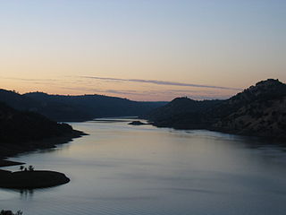
WDon Pedro Reservoir, also known as Lake Don Pedro, is a reservoir formed by the construction of the New Don Pedro Dam across the Tuolumne River in Tuolumne County, California, United States.
 W
WDonner Memorial State Park is a state park of California, US, preserving the site of the Donner Camp, where members of the ill-fated Donner Party were trapped by weather during the winter of 1846–1847. Caught without shelter or adequate supplies, members of the group resorted to cannibalism to survive. The Sierra Nevada site has been designated a National Historic Landmark. The state park contains the Emigrant Trail Museum and the Pioneer Monument dedicated to the travelers of the Emigrant Trail.
 W
WThe Eddy Arboretum is located at the Institute of Forest Genetics in the Sierra Nevada near Placerville, in El Dorado County, eastern California.
 W
WEldorado National Forest is a U.S. National Forest located in the central Sierra Nevada mountain range, in eastern California.
 W
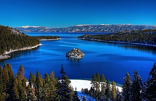
WEmerald Bay State Park is a state park of California in the United States, centered on Lake Tahoe's Emerald Bay, a National Natural Landmark. Park features include Eagle Falls and Vikingsholm, a 38-room mansion that is considered one of the finest examples of Scandinavian architecture in the United States. The architect was Leonard Palme, who was hired by his aunt Laura Knight to design and build Vikingsholm. The park contains the only island in Lake Tahoe, Fannette Island. The park is accessible by California State Route 89 near the southwest shore of the lake. Emerald Bay is one of Lake Tahoe's most photographed and popular locations.
 W
WThe Emigrant Wilderness of Stanislaus National Forest is a wilderness area in the Sierra Nevada. It is bordered by Yosemite National Park on the south, the Toiyabe National Forest and the Hoover Wilderness on the east, and State Route 108 over Sonora Pass on the north. It is an elongated area that extends northeast about 25 miles (40 km) in length and up to 15 miles (24 km) in width. Watersheds drain to the Stanislaus and Tuolumne Rivers. This area is entirely within Tuolumne County, California and is approximately 140 miles (230 km) east of San Francisco, California and 50 miles (80 km) south of Lake Tahoe.
 W
WThe Giant Sequoia National Monument is a 328,000-acre (1,330 km2) U.S. National Monument located in the southern Sierra Nevada in eastern central California. It is administered by the U.S. Forest Service as part of the Sequoia National Forest and includes 38 of the 39 Giant Sequoia groves that are located in the Sequoia National Forest, about half of the sequoia groves currently in existence, including one of the ten largest Giant Sequoias, the Boole Tree, which is 269 feet high with a base circumference of 112 feet. The forest covers 824 square miles.
 W
WThe Golden Trout Wilderness is a federally designated wilderness area in the Sierra Nevada, in Tulare County and Inyo County, California. It is located 40 miles (64 km) east of Porterville, California within Inyo National Forest and Sequoia National Forest.
 W
WThe Granite Chief Wilderness is a 19,048 acre (77 km2) federally designated wilderness area of the Tahoe National Forest. Created by the California Wilderness Act of 1984, it is located in the Sierra Nevada mountains west of Lake Tahoe in California, USA. It is managed by the US Forest Service Tahoe National Forest. Elevations range from 4,800 feet (1,500 m) to 9,019 feet (2,749 m) at the summit of Granite Chief.
 W
WGrover Hot Springs State Park is a state park of California, USA, containing natural hot springs on the eastern side of the Sierra Nevada. Park amenities include a swimming pool complex fed by the hot springs, as well as a campground, picnic area, and hiking trails. The 553-acre (224 ha) park was established in 1959.
 W
WIndian Grinding Rock State Historic Park is a California State Park, preserving an outcropping of marbleized limestone with some 1,185 mortar holes—the largest collection of bedrock mortars in North America. It is located in the Sierra Nevada foothills, 8 miles (13 km) east of Jackson. The park is nestled in a little valley 2,400 feet (732 m) above sea level, with open meadows and large specimens of valley oak that once provided the Miwok peoples of this area with an ample supply of acorns. The 135-acre (55 ha) park was established in 1962 and listed on the National Register of Historic Places in 1971.
 W
WInyo National Forest is a United States National Forest covering parts of the eastern Sierra Nevada of California and the White Mountains of California and Nevada. The forest hosts several superlatives, including Mount Whitney, the highest point in the contiguous United States; Boundary Peak, highest point in Nevada; and the Ancient Bristlecone Pine Forest that protects the oldest trees in the world. The forest, encompassing much of Owens Valley, was established by Theodore Roosevelt as a way of sectioning off land to accommodate the Los Angeles Aqueduct project in 1907, making the Inyo National Forest one of the least wooded forests in the United States' system.
WJennie Lakes Wilderness is a protected area in the Sierra Nevada, in Tulare County, California. It is located 60 miles (97 km) east of Fresno and managed by the US Forest Service.
 W
WThe John Muir Wilderness is a wilderness area that extends along the crest of the Sierra Nevada of California for 90 miles (140 km), in the Inyo and Sierra National Forests. Established in 1964 by the Wilderness Act and named for naturalist John Muir, it contains 581,000 acres (2,350 km2). The wilderness lies along the eastern escarpment of the Sierra from near Mammoth Lakes and Devils Postpile National Monument in the north, to Cottonwood Pass near Mount Whitney in the south. The wilderness area also spans the Sierra crest north of Kings Canyon National Park, and extends on the west side of the park down to the Monarch Wilderness.
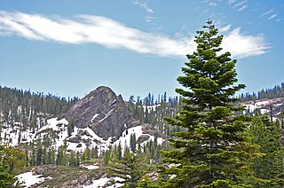
WThe Kaiser Wilderness is a federally designated wilderness protected area located 70 miles (110 km) northeast of Fresno in the state of California, USA. It was added to the National Wilderness Preservation System by the United States Congress on October 19, 1976. The wilderness is 22,700 acres (92 km2) in size, is one of five wilderness areas within the Sierra National Forest and is managed by the US Forest Service.
WThe Kiavah Wilderness is a federally designated wilderness area located in the Mojave Desert, Scodie Mountains, and southern Sierra Nevada in Kern County, California, United States. California State Route 178 connects the town of Lake Isabella to State Highway 14 in the east, crossing Walker Pass at the north boundary of the wilderness.
 W
WKings Canyon National Park is an American national park in the southern Sierra Nevada, in Fresno and Tulare Counties, California. Originally established in 1890 as General Grant National Park, the park was greatly expanded and renamed to Kings Canyon National Park on March 4, 1940. The park's namesake, Kings Canyon, is a rugged glacier-carved valley more than a mile (1,600 m) deep. Other natural features include multiple 14,000-foot (4,300 m) peaks, high mountain meadows, swift-flowing rivers, and some of the world's largest stands of giant sequoia trees. Kings Canyon is north of and contiguous with Sequoia National Park, and both parks are jointly administered by the National Park Service as the Sequoia and Kings Canyon National Parks.
 W
WLake Tahoe–Nevada State Park is a state park comprising multiple management units and public recreation areas on the northeast shores of Lake Tahoe in the U.S. state of Nevada. The park covers approximately 14,301 acres (5,787 ha). The Marlette Lake Water System, which is listed on the National Register of Historic Places and as a Historic Civil Engineering Landmark, lies within park boundaries.
 W
WMalakoff Diggins State Historic Park is a state park unit preserving the largest hydraulic mining site in California, United States. The mine was one of several hydraulic mining sites at the center of the 1882 landmark case Woodruff v. North Bloomfield Mining and Gravel Company. The mine pit and several Gold Rush-era buildings are listed on the National Register of Historic Places as the Malakoff Diggins-North Bloomfield Historic District. The "canyon" is 7,000 feet (2,100 m) long, as much as 3,000 feet (910 m) wide, and nearly 600 feet (180 m) deep in places. Visitors can see huge cliffs carved by mighty streams of water, results of the mining technique of washing away entire mountains of gravel to wash out the gold. The park is a 26-mile (42 km) drive north-east of Nevada City, California, in the Gold Rush country. The 3,143-acre (1,272 ha) park was established in 1965.
 W
WThe Mokelumne Wilderness is a 105,165-acre federally designated wilderness area located 70 miles (110 km) east of Sacramento, California. It is within the boundaries of three national forests: Stanislaus, Eldorado and Toiyabe. First protected under the Wilderness Act of 1964, the Mokelumne’s borders were expanded under the California Wilderness Act of 1984 with the addition of 55,000 acres. The wilderness takes its name from the Mokelumne River, which was named after a Mi-wok Indian village located on the riverbank in California's Central Valley.
WThe Monarch Wilderness is a federally designated wilderness area located 70 miles east of Fresno, California, in the Sierra Nevada mountain range. It encompasses 44,896 acres (181.69 km2) within both the Sequoia National Forest and the Sierra National Forest and is managed by the United States Forest Service. Elevations range from 950 feet (290 m) to 11,081 ft (3,377 m).
 W
WThe Mono Basin National Forest Scenic Area is a protected area in Eastern California that surrounds Mono Lake and the northern half of the Mono Craters volcanic field. It is administered by the Inyo National Forest as a unit of the National Forest Scenic Area program, under the U.S. Forest Service.
 W
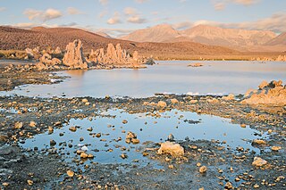
WMono Lake Tufa State Natural Reserve is located near Yosemite National Park within Mono County, in eastern California. It was established in 1981 by the California State Legislature to preserve the natural limestone "tufa tower" formations at Mono Lake.
 W
WThe Owens Peak Wilderness is a 73,767-acre (298.52 km2) wilderness area comprising the rugged eastern face of the Sierra Nevada Mountains. Owens Peak (8,445 ft) is the high point. The land was set aside with the passage of the California Desert Protection Act of 1994 by the US Congress.
 W
WPine Hill Ecological Reserve is a nature reserve of 403 acres (1.63 km2) located due east of Folsom Lake in the Sierra Nevada foothills, in El Dorado County, California. The reserve was established in 1979, and is managed by the California Department of Fish and Game.
 W
WPlumas National Forest is a 1,146,000-acre (4,638 km2) United States National Forest located at the northern terminus of the Sierra Nevada, in northern California. The Forest was named after its primary watershed, the Rio de las Plumas, or Feather River.
 W
WPlumas-Eureka State Park is a California state park located in the Sierra Nevada and Cascade Range in Plumas County, California.
 W
WRobbers Roost is a rock formation in the foothills of the Scodie Mountains portion of the Southern Sierra Nevada Mountain Range in the North Mojave Desert. The formation overlooks the southern portion of the Indian Wells Valley. The nearest municipality is Ridgecrest, California. The Los Angeles Aqueduct is within several hundred yards of the formation. The area is managed by the Bureau of Land Management. Robbers Roost lies west of Freeman Junction, which is approximately at the intersection of California highways 178 and 14.
 W
WThe Sacatar Trail Wilderness is a federally designated wilderness area located 20 miles (32 km) northwest of Ridgecrest, California USA. It was created in 1994 with the passage of the California Desert Protection Act - Public Law 103-433 - and is managed by the Bureau of Land Management (BLM). The wilderness is 51,900 acres (210 km2) in size and protects portions of the southern Sierra Nevada Mountain Range.
WThe Scodie Mountains are a sub-mountain range of the Southern Sierra Nevada rising from the Mojave Desert, and located in Kern County, California.
 W
WSequoia National Forest is located in the southern Sierra Nevada mountains of California. The U.S. National Forest is named for the majestic Giant Sequoia trees which populate 38 distinct groves within the boundaries of the forest.
 W
WSequoia National Park is an American national park in the southern Sierra Nevada east of Visalia, California. The park was established on September 25, 1890 to protect 404,064 acres of forested mountainous terrain. Encompassing a vertical relief of nearly 13,000 feet (4,000 m), the park contains the highest point in the contiguous United States, Mount Whitney, at 14,505 feet (4,421 m) above sea level. The park is south of, and contiguous with, Kings Canyon National Park; both parks are administered by the National Park Service together as the Sequoia and Kings Canyon National Parks. UNESCO designated the areas as Sequoia-Kings Canyon Biosphere Reserve in 1976.
 W
WSierra National Forest is a U.S. National Forest located on the western slope of central Sierra Nevada in Central California and bounded on the northwest by Yosemite National Park and the south by Kings Canyon National Park. The forest is known for its mountain scenery and beautiful lakes. Forest headquarters are located in Clovis, California. There are local ranger district offices in North Fork and Prather.
WThe South Sierra Wilderness is a federally designated wilderness area in the Southern Sierra Nevada, in eastern California. It is located 65 miles (105 km) northeast of Bakersfield, and is southwest of Owens Lake and Olancha.
 W
WSouth Yuba River State Park is located along the South Fork of the Yuba River in the Sierra Nevada, within Nevada County, in Northern California.
 W
WStanislaus National Forest is a United States national forest which manages 898,099 acres of land in four counties in the Sierra Nevada in Northern California. It was established on February 22, 1897, making it one of the oldest national forests. It was named after the Stanislaus River.
 W
WTahoe National Forest is a United States National Forest located in California, northwest of Lake Tahoe. It includes the 8,587-foot (2,617 m) peak of Sierra Buttes, near Sierra City, which has views of Mount Lassen and Mount Shasta. It is located in parts of six counties: Sierra, Placer, Nevada, Yuba, Plumas and El Dorado. The forest has a total area of 871,495 acres. Its headquarters is in Nevada City, California. There are local ranger district offices in Camptonville, Foresthill, Sierraville and Truckee.
WThe Teakettle Experimental Forest is a part of the Sierra National Forest that is set aside for research into forest ecology. The forest is located 80 kilometres (50 mi) east of Fresno, California, between Yosemite and Kings Canyon National Parks. The area is old-growth forest at 2,000 to 2,800 metres elevation and consists primarily of mixed-conifer and red fir forest common on the western slope of the Sierra Nevada.
 W
WThe Wassama Round House State Historic Park is in the Sierra Nevada foothills, in Madera County of central California.
 W
WThe Whiskeytown–Shasta–Trinity National Recreation Area is a United States National Recreation Area in northern California.
 W
WYosemite National Park is an American national park in the western Sierra Nevada of Central California, bounded on the southeast by Sierra National Forest and on the northwest by Stanislaus National Forest. The park is managed by the National Park Service and covers an area of 748,436 acres and sits in four counties: centered in Tuolumne and Mariposa, extending north and east to Mono and south to Madera County. Designated a World Heritage Site in 1984, Yosemite is internationally recognized for its granite cliffs, waterfalls, clear streams, giant sequoia groves, lakes, mountains, meadows, glaciers, and biological diversity. Almost 95% of the park is designated wilderness.