 W
WThe Coast Ranges of California span 400 miles (644 km) from Del Norte or Humboldt County, California, south to Santa Barbara County. The other three coastal California mountain ranges are the Transverse Ranges, Peninsular Ranges and the Klamath Mountains.
 W
WThe Anticline Ridge is a ridge, southeast of Joaquin Ridge, declining from its 3,629 foot / 1,106 meter high point, Black Mountain in the north at 36°18′16″N 120°24′12″W, to the southeast into low hills bound on the southeast by Los Gatos Creek that divides it from the Guijarral Hills. It is located in the inner California Coast Ranges, in Fresno County, California, east of the town of Coalinga. Anticline Ridge and Guijarral Hills divides Pleasant Valley from the San Joaquin Valley to the east. California State routes 33 and 198, which join together for the stretch through and north of Coalinga, cut across the Coalinga field and cross Anticline Ridge.
 W
WThe Berkeley Hills are a range of the Pacific Coast Ranges that overlook the northeast side of the valley that encompasses San Francisco Bay. They were previously called the "Contra Costa Range/Hills", but with the establishment of Berkeley and the University of California, the current usage was applied by geographers and gazetteers.
 W
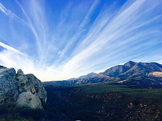
WBerryessa Snow Mountain National Monument is a national monument of the United States comprising 330,780 acres (133,860 ha) of the California Coast Ranges in Napa, Yolo, Solano, Lake, Colusa, Glenn and Mendocino counties in northern California. Cache Creek Wilderness is located within the monument.
WThe Big Blue Hills are a low mountain range in west Fresno County, in the western San Joaquin Valley of central California.
 W
WThe policies protecting land used in Big Sur are some of the most restrictive local-use standards in California, and are widely regarded as one of the most restrictive development protections anywhere. The program protects viewsheds from the highway and many vantage points, and severely restricts the density of development. About 60% of the coastal region is owned by governmental or private agencies which do not allow any development. The majority of the interior region is part of the Los Padres National Forest, Ventana Wilderness, Silver Peak Wilderness or Fort Hunter Liggett. The area is protected by the Big Sur Local Coastal Plan, which preserves it as "open space, a small residential community, and agricultural ranching." Its intention is "preserving the environment and visual access to it, the policies of the local coastal plan are to minimize, or limit, all destination activities."
 W
WThe Briones Hills form a low mountain range in western Contra Costa County, in the East Bay region of the San Francisco Bay Area, California, United States.
WMount Buchon, also known as the San Luis Range, is a mountain range in San Luis Obispo County, California.
 W
WThe Caliente Range is a west-east trending zone of uplift mountains in the California Coast Ranges, in central California. The highest peak of the range is Caliente Mountain at 5,106 feet (1,556 m) in elevation, located in southeastern San Luis Obispo County.
WThe Capay Hills are a low mountain range of the Inner Northern California Coast Ranges System, in Yolo County, California.
 W
WThe Carrizo Plain (Obispeño: tšɨłkukunɨtš, "Place of the rabbits"; is a large enclosed grassland plain, approximately 50 miles long and up to 15 miles across, in southeastern San Luis Obispo County, California, about 100 miles northwest of Los Angeles. It contains the 246,812-acre Carrizo Plain National Monument, and it is the largest single native grassland remaining in California. It includes Painted Rock in the Carrizo Plain Rock Art Discontiguous District, which is listed on the National Register of Historic Places. In 2012 it was further designated a National Historic Landmark due to its archeological value. The San Andreas Fault occurs along the eastern edge of the Carrizo Plain at the western base of the Temblor Range.
 W
WThe Cholame Hills are a low mountain range in extreme southeastern Monterey County, California.
WThe Ciervo Hills are a low mountain range in west Fresno County, in the western San Joaquin Valley of central California.
 W
WThe Cuyama Valley is a valley along the Cuyama River in central California, in northern Santa Barbara, southern San Luis Obispo, southwestern Kern, and northwestern Ventura counties. It is about two hours driving time from both Los Angeles and the Santa Barbara area.
 W
WThe Diablo Range is a mountain range in the California Coast Ranges subdivision of the Pacific Coast Ranges in northern California, United States. It is stretches from the eastern San Francisco Bay area at its northern end to the Salinas Valley area at its southern end.
WThe Flynn Hills are a mountain range in Mendocino County, California.
WThe Gabilan Range or Gabilan Mountains are a mountain range in the Southern Inner California Coast Ranges System, located in Monterey County and San Benito County of central California. Pinnacles National Park is located in the southern section of the range.
 W
WThe Geysers is the world's largest geothermal field, containing a complex of 18 geothermal power plants, drawing steam from more than 350 wells, located in the Mayacamas Mountains approximately 72 miles (116 km) north of San Francisco, California.
WThe Griswold Hills are a low mountain range in the Southern Inner California Coast Ranges System, in southeastern San Benito County, central California.
WThe Guijarral Hills are a range of low hills in the inner California Coast Ranges, in Fresno County, California, about seven miles east of the town of Coalinga. Guijarral is derived from a Spanish word meaning "heap of pebbles".
WThe Howell Mountains, which are also known as the Mt. George Range, are one of the California Coast Ranges. They divide the Suisun Valley on the east side, from Napa Valley on the west. Historically the southern part of the range has been referred to as both the Sierra de Suscol and as the Sierra de Napa.
WThe Irish Hills are a low mountain range of the southern outer California Coast Ranges in western San Luis Obispo County, California, and the state's Central Coast region.
WThe Jacalitos Hills are a low mountain range in western Fresno County, central California.
WThe Kettleman Hills is a low mountain range of the interior California Coast Ranges, in western Kings County, California. It is a northwest-southeast trending line of hills about 30 miles long which parallels the San Andreas Fault to the west.
 W
WThe King Range is a mountain range of the Outer Northern California Coast Ranges System, located entirely within Humboldt County on the North Coast of California.
WThe La Panza Range is a mountain range in the Central Coast of California region in San Luis Obispo County, east of the small town of Santa Margarita. It is one of the California Coast Ranges and in the Los Padres National Forest.
WLittle Blue Peak is highest point on Little Blue Ridge in the Northern Coast Ranges, located on the boundary of Yolo and Lake counties in northern California.
 W
WLos Padres National Forest is a United States national forest in southern and central California. Administered by the United States Forest Service, Los Padres includes most of the mountainous land along the California coast from Ventura to Monterey, extending inland. Elevations range from sea level to 8,847 feet (2,697 m).
 W
WThe Maacama Fault is a right lateral-moving (dextral) geologic fault located in the Coast Ranges of northwestern California. It is considered to be the northernmost segment of the Hayward Fault subsystem of the San Andreas Fault zone. Creep along the Maacama is about 8 mm per year, consistent with the steady movement along the rest of the Hayward Fault system. It is also capable of producing large earthquakes.
WThe term Marble Mountains is a common term for the northwestern portion of the Salmon Mountains range in northwestern California. The Salmon Mountains are themselves a sub-range of the Klamath Mountains. The local name derives from Marble Mountain and Black Marble Mountain, prominent peaks and the namesake of the surrounding Marble Mountain Wilderness Area. The term "Marble Mountains" is commonly applied not only to the ridges of Marble Mountain and Black Marble Mountain themselves but as a name for the northwestern ranges of the Salmon Mountains.
 W
WThe Marin Hills are a series of steep high ridges and peaks in southern Marin County. They are a part of the long Pacific Coast Ranges mountain system. The centerpoint of these hills is the 2,571 foot Mount Tamalpais near Mill Valley. The hills are bordered to the north by the Santa Rosa Plain and Laguna de Santa Rosa; to the east by San Pablo Bay, the northern arm of San Francisco Bay; to the south by Golden Gate Strait; and to the west by the San Andreas Fault, running through Tomales Bay, Olema Valley, Bolinas Lagoon, and Stinson Beach. Parts of the hills are protected for their scenic beauty by Mount Tamalpais State Park and the Golden Gate National Recreation Area. The many ridges and peaks of these hills form a dramatic backdrop to the Golden Gate Bridge, the San Francisco skyline, and several towns around Richardson Bay when viewed from the south.
 W
WThe Mayacamas Mountains are located in northwestern California in the United States. The mountain range is part of the Northern Inner Coast Ranges, of the California Coast Ranges System.
 W
WThe Mendocino National Forest is located in the Coastal Mountain Range in northwestern California and comprises 913,306 acres (3,696 km2). It is the only national forest in the state of California without a major paved road entering it. There are a variety of recreational opportunities — camping, hiking, mountain biking, paragliding, backpacking, boating, fishing, hunting, nature study, photography, and off-highway vehicle travel.
WThe Oat Hills are a mountain range in Colusa County, California.
WThe Panoche Hills are a low mountain range in the Southern Inner California Coast Ranges System, in western Fresno County, California.
WThe Panorama Hills are a mountain range in the interior California Coast Ranges, in eastern San Luis Obispo County, California.
WThe Potrero Hills are a low mountain range in the Sacramento–San Joaquin River Delta area of southern Solano County, California.
WThe Purisima Hills are a northwest-to-southeast trending low mountain range of the Outer Southern California Coast Ranges, located in Santa Barbara County, California. They divide the Santa Ynez Valley on the south from the Los Alamos Valley on the north.
WThe Pyramid Hills are a mountain range in the interior California Coast Ranges, in western Kings County, California.
WThe Red Hills are a low mountain range in the interior California Coast Ranges, in eastern San Luis Obispo County, California.
 W
WThe Salinian Block or Salinian terrane is a geologic terrane which lies west of the main trace of the San Andreas Fault system in California. It is bounded on the south by the Big Pine Fault in Ventura County and on the west by the Nacimiento Fault. It was named for the Salinas Valley in Monterey County, California.
WThe San Leandro Hills are a low mountain range of the Southern Inner California Coast Ranges System, located on the eastern side of the San Francisco Bay. Geologically, they are a southern continuation of the Berkeley Hills on the north.
WThe Santa Cruz Mountains, part of the Pacific Coast Ranges, are a mountain range in central and northern California, United States. They form a ridge down the San Francisco Peninsula, south of San Francisco. They separate the Pacific Ocean from the San Francisco Bay and the Santa Clara Valley, and continue south to the Central Coast, bordering Monterey Bay and ending at the Salinas Valley. The range passes through the counties of San Mateo, Santa Clara, Santa Cruz, San Benito and Monterey, with the Pajaro River forming the southern boundary.
WThe Santa Lucia Mountains or Santa Lucia Range is a rugged mountain range in coastal central California, running from Carmel southeast for 140 miles (230 km) to the Cuyama River in San Luis Obispo County. The range is never more than 11 miles (18 km) from the coast. The range forms the steepest coastal slope in the contiguous United States. Cone Peak at 5,158 feet (1,572 m) tall and three miles (5 km) from the coast, is the highest peak in proximity to the ocean in the lower 48 United States. The range was a barrier to exploring the coast of central California for early Spanish explorers.
WThe Shale Hills are a low mountain range in the interior California Coast Ranges, in western Kern County, California.
WSierra de Salinas is a mountain range in the California Coast Ranges, located in central Monterey County, California. The range is a part of the Salinian Block and lies between the Santa Lucia Range to the west and the Salinas Valley, Salinas River, and Gabilan Range to the east.
 W
WThe Sierra Madre Mountains are a mountain range primarily in northern Santa Barbara County and extending into northwestern Ventura County in Southern California, western United States. It is a range of the Inner South Coast Ranges group, and is the southernmost reach of the California Coast Ranges, which are themselves part of the Pacific Coast Ranges of western North America.
WThe Sonoma Mountains are a northwest-southeast trending mountain range of the Inner Coast Ranges in the California Coast Ranges System, located in Sonoma County, Northern California.
 W
WMount Tamalpais is a peak in Marin County, California, United States, often considered symbolic of Marin County. Much of Mount Tamalpais is protected within public lands such as Mount Tamalpais State Park, the Marin Municipal Water District watershed, and National Park Service land, such as Muir Woods.
WThe Telephone Hills are a low mountain range in the interior California Coast Ranges, in western Kern County, California.
 W
WThe Temblor Range is a mountain range within the California Coast Ranges, at the southwestern extremity of the San Joaquin Valley in California in the United States. It runs in a northwest-southeasterly direction along the borders of Kern County and San Luis Obispo County. The name of the range is from Spanish temblor meaning "tremor", referring to earthquakes. The San Andreas Fault Zone runs parallel to the range at the base of its western slope, on the eastern side of the Carrizo Plain, while the Antelope Plain, location of the enormous Midway Sunset, South Belridge, and Cymric oil fields, lies to the northeast.
 W
WThe Trinity Alps are a mountain range in Siskiyou County and Trinity County, in Northern California. They are a subrange of the Klamath Mountains and located to the north of Weaverville.
 W
WThe Trinity Mountains are a subrange of the Klamath Mountains, one of the ranges within the California Coast Ranges and part the greater Pacific Coast Ranges, the coastal mountain system extending from Mexico to Alaska. The Trinity Mountains subrange rises in Siskiyou County and eastern Trinity County, Northern California.
 W
WThe Tumey Hills are a low mountain range in the interior California Coast Ranges, in western Fresno County, California. The Tumey Hills area is part of the U.S. Department of Bureau of Land Management (BLM), which is a division of the United States Department Of The Interior. This BLM land is under Fire Season Vehicle Restrictions from mid-April to mid-October. No motorized access is allowed during this time period.
 W
WThe Vaca Mountains are a mountain range in Napa and Solano Counties, California that is one of the California Coast Ranges. They represent the easternmost of the Inner Coast Ranges in north−central California, and divide the Suisun Valley on their west, from the Sacramento Valley on their east.
WThe Yountville Hills are a mountain range in Napa County, California on the northwest side of the town of Yountville. The West Napa Fault extends into the Yountville Hills, as mapped in 2005.