 W
WYoho National Park is a national park of Canada in British Columbia. It is located within the Rocky Mountains along the western slope of the Continental Divide of the Americas in southeastern British Columbia. The word Yoho is a Cree expression of amazement or awe, and it is an apt description for the spectacular landscape of massive ice fields and mountain peaks that rank among the highest in the Canadian Rockies. Yoho NP is bordered by Kootenay National Park on the southern side and Banff National Park on the eastern side in Alberta.
 W
WAbbot Pass lies between Mount Lefroy and Mount Victoria, in the divide between the valleys of Lake O'Hara and Lake Louise. It was named for Philip Stanley Abbot who died in 1896 in an attempt to climb Mount Lefroy with Charles Fay, Charles Thompson, and George T. Little.
 W
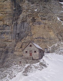
WThe Abbot Pass hut is an alpine hut located at an altitude of 2925 metres in Abbot Pass in the Rocky Mountains in Alberta, Canada. It is nestled between Mount Victoria and Mount Lefroy, straddling the continental divide, which, in this region, defines the boundary between Banff National Park in Alberta and Yoho National Park in British Columbia. While close to the border, the hut lies entirely in Banff National Park, and is the second-highest permanently habitable structure in Canada. The hut is maintained by the Alpine Club of Canada.
 W
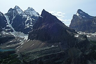
WMount Allen is a mountain in the Canadian Rockies, located on the Continental Divide, which forms the provincial boundary between British Columbia and Alberta in this region. J. Monroe Thorington named this mountain for Samuel Evans Stokes Allen in 1924. Allen was an American cartographer who mapped this area of the Rockies in 1894-95. Allen had named this mountain "Shappee", the Stoney First Nations word for number 6 in reference to Allen's naming of the ten mountains in the Valley of the Ten Peaks. The peak forms part of the backdrop to Moraine Lake in Banff National Park.
 W
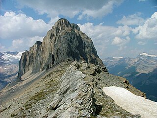
WMount Bosworth is located in the Canadian Rockies on the border of Alberta and British Columbia. The mountain is situated immediately northwest of Kicking Horse Pass and straddles the shared border of Banff National Park with Yoho National Park. It was named in 1903 after George Morris Bosworth, an executive and long-time employee of the Canadian Pacific Railway.
 W
WMount Burgess, 2,599 m (8,527 ft), is a mountain in Yoho National Park and is part of the Canadian Rockies. It is located in the southwest buttress of Burgess Pass in the Emerald River and Kicking Horse River Valleys.
 W
WThe Burgess Shale is a fossil-bearing deposit exposed in the Canadian Rockies of British Columbia, Canada. It is famous for the exceptional preservation of the soft parts of its fossils. At 508 million years old, it is one of the earliest fossil beds containing soft-part imprints.
 W
WMount Carnarvon is a 3,046-metre (9,993-foot) mountain summit located in the Kiwetinok River Valley of Yoho National Park, in the Canadian Rockies of British Columbia, Canada. Its nearest higher peak is The President, 3.9 km (2.4 mi) to the north-northeast. Both are part of the President Range which is a subset of the Waputik Mountains. Mount Carnarvon is situated five kilometers northwest of Emerald Lake, but is hidden from view behind Emerald Peak. However, Carnarvon is visible from Highway 1, the Trans-Canada Highway. The months July through September offer the most favorable weather for viewing or climbing Mount Carnarvon.
 W
WThe Cathedral Formation is a stratigraphic unit in the southern Canadian Rockies of Alberta and British Columbia, on the western edge of the Western Canada Sedimentary Basin. It is a thick sequence of carbonate rocks of Middle Cambrian age. It was named for Cathedral Mountain in Yoho National Park by Charles Doolittle Walcott, the discoverer of the Burgess shale fossils.
 W
WChancellor Peak is a 3,266-metre (10,715-foot) mountain summit located in Yoho National Park, in the Canadian Rockies of British Columbia, Canada. Its nearest higher peak is Mount Vaux, 4.0 km (2.5 mi) to the north-northwest. Both are part of the Ottertail Range. Chancellor Peak is a landmark in the Kicking Horse River valley and can be seen from the Trans-Canada Highway midway between Golden and Field.
 W
WMount Dennis is a 2,549-metre (8,363-foot) mountain summit located three kilometres south of Field in Yoho National Park, in the Canadian Rockies of British Columbia, Canada. Its nearest higher peak is Mount Stephen, 4.0 km (2.5 mi) to the northeast. Mount Burgess is six kilometres north on the opposite side of the Kicking Horse River valley. Mount Dennis has over 1,200-metre (3,900-foot) of vertical relief above Highway 1, the Trans-Canada Highway, which traverses the northwest foot of the mountain.
 W
W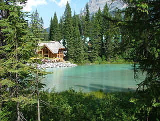 W
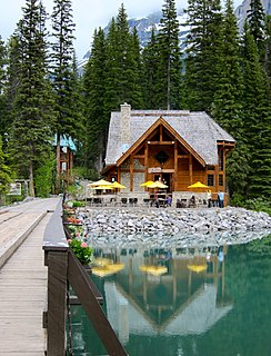
WEmerald Lake is located in Yoho National Park, British Columbia, Canada. It is the largest of Yoho's 61 lakes and ponds, as well as one of the park's premier tourist attractions. Emerald Lake Lodge, a high-end lodge perched on the edge of the lake, provides local accommodation. A 5.2 km (3.2 mi) hiking trail circuits the lake, the first half of which is accessible to wheelchairs and strollers. During the summer months, canoe rentals are available; in the winter, the lake is a popular cross country skiing destination.
 W
WEmerald Peak is a 2,701-metre (8,862-foot) mountain summit located in Yoho National Park, in the Canadian Rockies of British Columbia, Canada. Its nearest higher peak is Mount Carnarvon, 1.7 km (1.1 mi) to the northwest. Both are part of the President Range which is a subset of the Waputik Mountains. Emerald Peak is visible from Emerald Lake, rising 1,256-metre (4,121-foot) above the northwest shore. The mountain's name was officially adopted in 1924 when approved by the Geographical Names Board of Canada, in association with Emerald Lake, which in turn was named in 1900 on account of its color.
 W
WThe Emerald River is a short river in British Columbia. It is about 6.5 kilometres (4.0 mi) long and drains the waters of Emerald Lake to the Kicking Horse River. The river exits the lake's south end and flows in a southern direction for about 6.5 kilometres (4.0 mi) to its mouth, which is at almost exactly the same place as the mouth of the Amiskwi River. It picks up three named tributaries; Hamilton Creek, Russell Creek and Kendel Creek.
 W
WField is an unincorporated community of approximately 169 people located in the Kicking Horse River valley of southeastern British Columbia, Canada, within the confines of Yoho National Park. At an elevation of 1,256 m (4,121 ft), it is 27 km (17 mi) west of Lake Louise along the Trans-Canada Highway, which provides the only road access to the town. The community is named for Cyrus West Field of Transatlantic telegraph cable fame, who visited the area in 1884.
 W
WMount Field is a mountain located about 10 km (6 mi) east of the town of Field in Yoho National Park, Canada. The mountain was named in 1884 after Cyrus West Field, an American merchant who had laid the first Atlantic cable, 1858, a second in 1866; Mr. Field was visiting the Canadian Rockies the year as a guest of the CPR who were building the national railway, at the naming of a station and a mountain.
 W
WMount Goodsir is the highest mountain in the Ottertail Range, a subrange of the Canadian Rockies in British Columbia. It is located in Yoho National Park, near its border with Kootenay National Park. The mountain has two major summits, the South Tower and the North Tower, 3,525 metres (11,565 ft).
 W
WMount Gordon is a 3,161-metre (10,371-foot) mountain summit located immediately west of the Continental Divide, in the Waputik Range of the Canadian Rockies in British Columbia, Canada. It is a glaciated dome situated in Yoho National Park, and is the highest point of the Wapta Icefield. Its nearest higher peak is Mount Baker, 8.8 km (5.5 mi) to the northwest.
 W
WThe Great Divide Trail (GDT) is a wilderness hiking trail in the Canadian Rockies. The trail closely follows the Great Divide between Alberta and British Columbia, crossing the divide more than 30 times. Its southern terminus is in Waterton Lakes National Park at the Canada–US border and its northern terminus is at Kakwa Lake in Kakwa Provincial Park, north of Jasper National Park. The trail is 1,130 km (700 mi) long and ranges in elevation from 1,055 m (3,461 ft) at Old Fort Point trailhead near Jasper to 2,590 m (8,500 ft) at an unnamed pass above Michele Lakes just south of the White Goat Wilderness Area.
 W
WHagen Peak is a 2,635-meter (8,645-foot) double summit mountain located on the western boundary of Yoho National Park in the Canadian Rockies of British Columbia, Canada. The mountain is situated 36 km (22 mi) northeast of Golden in the Blaeberry Valley, and less than 13 km (8.1 mi) from the Continental Divide. The mountain was named after Canadian Army Private Alfred G. Hagen of Field, BC, who was serving with the 10th Canadian Infantry Brigade when he was killed in 1944 World War II action, during the liberation of Calais, France. The mountain's name was officially adopted July 5, 1961, when approved by the Geographical Names Board of Canada.
 W
WThe Burgess Shale, a series of fossil beds in the Canadian Rockies, was first noticed in 1886 by Richard McConnell of the Geological Survey of Canada (GSC). His and subsequent finds, all from the Mount Stephen area, came to the attention of palaeontologist Charles Doolittle Walcott, who in 1907 found time to reconnoitre the area. He opened a quarry in 1910 and in a series of field trips brought back 65,000 specimens, which he identified as Middle Cambrian in age. Due to the quantity of fossils and the pressures of his other duties at the Smithsonian Institution, Walcott was only able to publish a series of "preliminary" papers, in which he classified the fossils within taxa that were already established. In a series of visits beginning in 1924, Harvard University professor Percy Raymond collected further fossils from Walcott's quarry and higher up on Fossil Ridge, where slightly different fossils were preserved.
 W
WMount Huber is a 3,348-metre (10,984-foot) summit located two kilometers east of Lake O'Hara in the Bow Range of Yoho National Park, in the Canadian Rockies of British Columbia, Canada. Its nearest higher peak is Mount Victoria, 1.0 km (0.62 mi) to the north-northeast. Mount Huber is a secondary summit of Mount Victoria which is on the Continental Divide.
 W
WMount Hungabee, officially Hungabee Mountain, is a mountain located on the boundaries of Banff National Park and Yoho National Park on the Continental Divide at the head of Paradise Valley. The peak was named in 1894 by Samuel Allen after the Stoney Indian word for "chieftain" as the mountain is higher than its neighbouring peaks. The mountain can be seen from the Icefields Parkway (#93) in the upper Bow Valley.
 W
WMount Hurd is a Canadian mountain in the Ottertail Range of the Rocky Mountains in British Columbia. It was named after Major Marshall Farnam Hurd (1823-1903) a Canadian Pacific Railway engineer and explorer. It was featured on a 1928 Canada Post 10¢ stamp based on a painting by Frederic Marlett Bell-Smith.
 W
WKicking Horse Pass is a high mountain pass across the Continental Divide of the Americas of the Canadian Rockies on the Alberta/British Columbia border, and lying within Yoho and Banff national parks. A National Historic Site of Canada, the pass is of historical significance because the main line of the Canadian Pacific Railway (CPR) was constructed between Lake Louise, Alberta and Field, British Columbia using this route in 1884, in preference to the originally planned route through the more northerly Yellowhead Pass.
 W
WMount King is a 2,868-metre (9,409-foot) mountain summit located in Yoho National Park, in the Canadian Rockies of British Columbia, Canada. Its nearest higher peak is Mount Deville, 5.0 km (3.1 mi) to the northwest. Both are in the Van Horne Range, which has the oldest mountains in the Rockies, and as such they are highly eroded. Mount King is a landmark that can be seen from Highway 1, the Trans-Canada Highway in the Kicking Horse valley and Kicking Horse Pass areas. The mountain is situated 14 kilometres southwest of Emerald Lake, and 13 km southwest of Field, British Columbia.
 W
WLake Oesa is a body of water located at an elevation of 2,267 metres (7,438 ft) in the mountains of Yoho National Park, near Field, British Columbia, Canada, while a trail at the far end of the lake leads to Abbot Hut.
 W
WMount Lefroy is a mountain on the Continental Divide, at the border of Alberta and British Columbia in western Canada. The mountain is located on the eastern side of Abbot Pass which separates Lake Louise in Banff National Park from Lake O'Hara in Yoho National Park. Mount Victoria lies immediately on the western side of the pass.
WMount McArthur is a mountain located in Yoho National Park, British Columbia, Canada. It was named in 1886 by Otto Koltz after James J. McArthur, a land surveyor who mapped the Canadian Rockies for the Canadian Pacific Railway.
 W
WMichael Peak is a 2,701-metre (8,862-foot) mountain summit located in Yoho National Park, in the Canadian Rockies of British Columbia, Canada. Its nearest higher peak is The President, 4.0 km (2.5 mi) to the west-northwest. Both are part of the President Range which is a subset of the Waputik Mountains. Michael Peak is a landmark seen 4.5 kilometres north-northeast of Emerald Lake, three kilometres southwest of Takakkaw Falls, and 10 kilometres north of Field, British Columbia.
 W
WMont des Poilus is a 3,166-metre (10,387-foot) mountain summit located in Yoho National Park, in the Canadian Rockies of British Columbia, Canada. Its nearest higher peak is Mount Baker, 8.0 km (5.0 mi) to the north. Both are part of the Waputik Mountains.
 W
WMount Stephen House was a hotel located in Field, British Columbia from 1886 to 1963. It was owned by the Canadian Pacific Railway (CPR), and was a central feature of Yoho National Park. It was named for the eponymous Mount Stephen, which was named for a president of the CPR, George Stephen.
 W
WNeptuak Mountain was named by Samuel E.S. Allen in 1894. "Neptuak" is the Stoney Indian word for "nine" as Neptuak Mountain is peak #9 in the Valley of the Ten Peaks. It is located on the Continental Divide, which is also the British Columbia-Alberta border in this region, and is in the Bow Range of the Park Ranges of the Canadian Rockies. The summit is a tripoint for Banff National Park, Kootenay National Park, and Yoho National Park, where the three parks share a common border.
 W
WMount Niles is a 2,967-metre (9,734-foot) summit located in the Waputik Range of Yoho National Park, in the Canadian Rockies of British Columbia, Canada. Its nearest higher peak is Mount Daly, 1.63 km (1.01 mi) to the immediate northeast. Takakkaw Falls is situated four km to the west, the Waputik Icefield lies to the north, and Sherbrooke Lake lies to the south.
 W
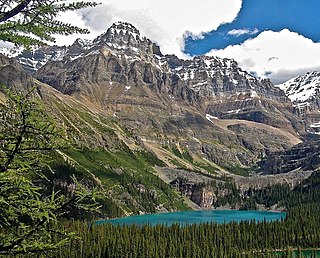
WLake O'Hara is a lake at an elevation of 2,020 metres (6,630 ft) in the alpine area of Yoho National Park, in the province of British Columbia, on the western side of the Great Divide with the province of Alberta and Banff National Park to the east. The lake and the valley are accessible through a bus service that is run by Parks Canada or by an 11 km hike along a road with an elevation gain of approximately 500m. However, people who hike up the road are not guaranteed a bus ride down. People who have reservations have priority for the bus spots for the ride down. Reservations for the bus, for day use, can be made through the Parks Canada Reservation website. Campsite reservations can be made up to three months in advance through the Lake O'Hara reservation line. It is strongly recommended that visitors make reservations in advance, as the bus does fill up and standby bus spots are not sold the day of bus departures.
 W
WOdaray Mountain is a 3,137-metre (10,292-foot) summit located west of Lake O'Hara in the Bow Range of Yoho National Park, in the Canadian Rockies of British Columbia, Canada. Its nearest higher peak is Mount Huber, 3.86 km (2.40 mi) to the east. The standard climbing route follows the southeast glacier and ridge starting from Elizabeth Parker hut. Pronunciation sounds like the two words "ode array".
 W
WPark Mountain is a 2,951-metre (9,682-foot) mountain summit located above the southwest shore of Lake McArthur in Yoho National Park, in the Bow Range of the Canadian Rockies of British Columbia, Canada. Its nearest higher peak is Mount Biddle, 3.0 km (1.9 mi) to the east. Park Mountain is situated four kilometres west of the Continental Divide, and 12 kilometres southeast of Field, British Columbia.
 W
WThe President is a mountain peak on The President/Vice-President Massif of the President Range, in eastern British Columbia. It is just north of Emerald Lake in Yoho National Park, near the Alpine Club of Canada's Stanley Mitchell hut.
 W
WSaint Nicholas Peak is a 2,938-metre (9,639-foot) mountain summit in the Rocky Mountains of Canada. It is located on the Continental Divide, on the Alberta-British Columbia border, in both Banff National Park and Yoho National Park. It lies at the eastern edge of the Wapta Icefield, and is part of the Waputik Mountains which are a sub-range of the Canadian Rockies.
 W
WMount Schaffer is a 2,691-metre (8,829-foot) mountain summit located one kilometre southwest of Lake O'Hara in Yoho National Park, in the Bow Range of the Canadian Rockies of British Columbia, Canada. Its nearest higher peak is Mount Biddle, 3.2 km (2.0 mi) to the southeast. Mount Schaffer is situated 3.5 kilometres west of the Continental Divide, and 12 kilometres southeast of Field, British Columbia.
 W
WSherbrooke Lake is a lake in Yoho National Park, British Columbia, Canada. The lake is bounded on the west by Mount Ogden 2,695 m (8,842 ft), Mount Niles 2,972 m (9,751 ft) to the north, and Paget Peak on the east side. The lake can be reached by following a three km hiking trail that begins from the Trans-Canada Highway across from Wapta Lake.
 W
WMount Stephen, 3,199 m (10,495 ft), is a mountain located in the Kicking Horse River Valley of Yoho National Park, ½ km east of Field, British Columbia, Canada. The mountain was named in 1886 for George Stephen, the first president of the Canadian Pacific Railway. The mountain is mainly composed of shales and dolomites from the Cambrian Period, some 550 million years ago. The Stephen Formation, a stratigraphical unit of the Western Canadian Sedimentary Basin was first described at the mountain and was named for it. Stephen has a subpeak known as Stephen SE1, at the end of a 1 km ridge, 132⁰ from the main peak, visible from Lake O'Hara.
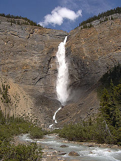
WTakakkaw Falls is a waterfall located in Yoho National Park, near Field, British Columbia in Canada. The falls have a total height of 373 metres (1,224 ft), making it the 2nd tallest waterfall in Canada. The main drop of the waterfall has a height of 254 metres (833 ft).
 W
WTrolltinder Mountain is a 2,912-metre (9,554-foot) mountain summit located immediately west of the Continental Divide, in the Waputik Range of the Canadian Rockies in British Columbia, Canada. It is situated in Yoho National Park, with its nearest higher peak being Mount Balfour, 1.0 km (0.62 mi) to the northeast, and Fairy Lake directly below its southern slope.
 W
WMount Vaux is a 3,310-metre (10,860-foot) mountain summit located in the Kicking Horse River valley of Yoho National Park, in the Ottertail Range of the Canadian Rockies in British Columbia, Canada. Its nearest higher peak is Mount Goodsir, 11.0 km (6.8 mi) to the southeast. Mount Vaux can be seen from Highway 1, the Trans-Canada Highway, which traverses the western foot of the mountain, as well as from Emerald Lake. Vaux is pronounced Vox, rhymes with box.
 W
WThe Vice President is a mountain on The President/Vice President Massif just north of Emerald Lake in Yoho National Park, near the Alpine Club of Canada's Stanley Mitchell hut. The Vice President was named Mount McNicoll in 1904 by Edward Whymper after David McNicoll, the VP of the Canadian Pacific Railway. In 1907, the mountain was renamed by the Alpine Club of Canada, after it was discovered that the name had already been used on a mountain near Rogers Pass.
 W
WWapta Falls is a waterfall of the Kicking Horse River located in Yoho National Park in British Columbia, Canada. It is the largest waterfall of the Kicking Horse River, at about 18 metres (59 ft) high and 107 metres (351 ft) wide. Its average flow can reach 96 cubic metres per second (3,400 cu ft/s). The name stems from a Nakoda word meaning "river".
 W
WThe Wapta Icefield is located on the Continental Divide in the Waputik Mountains of the Canadian Rockies, in the provinces of British Columbia and Alberta. The icefield is shared by Banff and Yoho National Parks and numerous outlet glaciers extend from the icefield, including the Vulture, Bow and Peyto Glaciers. Runoff from the icefields and outlet glaciers supply water to both the Kicking Horse and Bow Rivers, as well as numerous streams and lakes.
 W
WWapta Mountain is a mountain located in the Canadian Rocky Mountains between Emerald Lake and Yoho Valley in Yoho National Park, British Columbia, Canada. It stands just north of the ridge containing the Burgess Shale fossil beds. Along with The Vice President and Mount Burgess, Wapta Mountain forms the backdrop to Emerald Lake, and marks the southern end of the President Range.
 W
WThe Waputik Icefield is located on the Continental divide in the Canadian Rocky Mountains, in the provinces of British Columbia and Alberta. It is developed on the heights of the Waputik Range in the Central Main Ranges.
 W
WThe Yoho River is a silty, swift tributary of the Kicking Horse River in the Canadian province of British Columbia. The river is entirely within Yoho National Park.
 W
WYukness Mountain is a 2,851-metre (9,354-foot) summit located southeast of Lake O'Hara in the Bow Range of Yoho National Park, in the Canadian Rockies of British Columbia, Canada. Its nearest higher peak is Ringrose Peak, 1.0 km (0.62 mi) to the east.