 W
WEl Barco Lake is a lake in the Bío Bío Region of Chile, near the Callaqui stratovolcano.
 W
WBertrand Lake is a Chilean lake located in the Aysén del General Carlos Ibáñez del Campo Region. It is separated from Plomo Lake by a terminal moraine and is flanked on the west by the summits of the Cordón Contreras.
 W
WBudi Lake from the Mapudungun word Füzi which means salt, is a tidal brackish water lake located near the coast of La Araucanía Region, southern Chile. The lake is part of the boundaries between Saavedra and Teodoro Schmidt commune.
 W
WCaburgua Lake is located 23 km northeast of the city of Pucón, in the La Araucanía Region of Chile. Huerquehue National Park lies to the east of the lake. Like Villarrica Lake, it is part of Toltén River basin. During summer the outflow river may dry out but due to high levels of underground infiltration the waterfalls Ojos del Caburgua never run dry.
 W
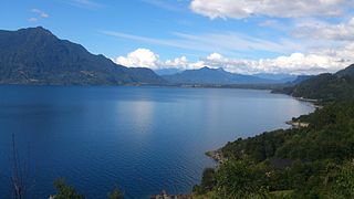
WCalafquén Lake is a lake of Chile, which straddles the border between the La Araucanía Region and Los Ríos Region. It is one of the Seven Lakes and forms part of the drainage basin of the Valdivia River.
 W
WFagnano Lake, also called Lake Cami, is a lake located on the main island of the Tierra del Fuego archipelago, and shared by Argentina and Chile.
 W
WChapo Lake is a lake of Chile located in Los Lagos Region. It lies immediately southeast of Calbuco volcano and south of Llanquihue National Reserve. Just south of the lake is Alerce Andino National Park.
 W
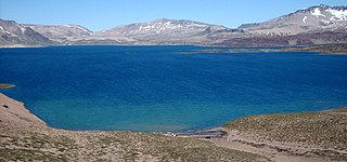
WChungará is a lake situated in the extreme north of Chile at an elevation of 4,517 metres (14,820 ft), in the Altiplano of Arica y Parinacota Region in the Lauca National Park. It has a surface area of about 21.5–22.5 square kilometres (8.3–8.7 sq mi) and has a maximum depth of about 26–40 metres (85–131 ft). It receives inflow through the Río Chungara with some minor additional inflows, and loses most of its water to evaporation; seepage into the Laguna Quta Qutani plays a minor role.
 W
WColbún Lake is a reservoir in the Maule Region in Chile, straddling the provinces of Talca and Linares. Located 48 km southeast of the city of Talca, the regional capital and 35 km northeast of the city of Linares and with an area of 5,700 hectares and a capacity of 1,490,000 m³, it is the largest artificial reservoir in Chile. The lake lies at an altitude of 440 metres above sea level.
 W
WColico Lake is located in the La Araucanía Region of Chile. The neighboring Caburgua Lake lies to the east of the lake and the Villarrica Lake to the south.
 W
WConguillío Lake is a lake located in the La Araucanía Region of Chile, within the Conguillío National Park. The lake was formed by the damming of the Trufultruful River caused by a lava flow from the Llaima volcano.
 W
WLaguna de Cotacotani or Quta Qutani is a lake located in the Andean Altiplano of the Parinacota Province, Arica-Parinacota Region, Chile. It lies 4 km northwest of Chungará Lake, which is one of the highest lakes in the world and is surrounded by several volcanoes, such as the Payachata volcanic group, Sajama volcano and Wallatiri.
 W
WCucao and Huillinco are two lakes in central Chiloé Island, Chile, linked by a strait forming one hydrologic lake. The two lakes are oriented in west-east fashion cutting off the Chilean Coast Range in Chiloé Island into two ranges; Piuchén to north and Pirulil to the south. The outlet of the lakes, Desaguadero or Cucao River lies at Cucao Lakes western end, and flows into the Pacific.
 W
WDickson Lake is a glacier lake in southern Patagonia located in the Southern Patagonian Ice Field, which since 1998 has been transformed into an international lake as it is crossed by the international boundary between Argentina and Chile due to the retreat of the Dickson glacier. Until that year, Dickson Lake was entirely within Chilean territory, at the northern end of the Torres del Paine National Park in the Magallanes y la Antártica Chilena Region, but it was unified with a lake that began to form in the 1980s by defrosting the melting of the Dickson, Cubo and Frías glaciers. That lake was on the Argentine side when the Agreement was signed to specify the route of the limit from Mount Fitz Roy to the Daudet Hill of 1998, in a sector adjacent to the Los Glaciares National Park, but without being part of it. The lake is fed by the glacier that shares its name and is drained by the Paine River. It receives the waters of Los Perros River, which starts at a proglacial lake that was formed during the retreat of Los Perros Glacier.
 W
WGalletué Lake, also spelled as Gualletué Lake, is located in the Andes of the La Araucanía Region of southern Chile. It is surrounded by mountains on three sides. Issuing from the lake on its eastern side is one of the two sources of the Biobío River, the other being nearby Icalma Lake.
 W
WGeneral Carrera Lake or Lake Buenos Aires is a lake located in Patagonia and shared by Argentina and Chile. Both names are internationally accepted.
 W
WGreve Lake is an ice dammed lake in Chile formed by the advance of Brüggen Glacier. It is fed by several glaciers. Lautaro volcano is located in its vicinity.
 W
WHuishue Lake, Mapudungun for bad place to live, is located in the Andes of the Lago Ranco commune in southern Chile. More precisely the lake is located 10 km south of Maihue Lake, 15 km northeast of Puyehue Volcano and 10 km west of the Chile-Argentina border.
 W
WIcalma Lake is a lake of glacial origin located in the Andes of the La Araucanía Region of Chile. A hamlet on the southern shore of the lake is also called Icalma. About 3 kilometres (1.9 mi) from the hamlet is Icalma Pass, 1,307 metres (4,288 ft) in elevation and on the border with Argentina. The pass is traversed by a road, unpaved in Chile in 2017 and sometimes impassable during the Southern Hemisphere winter due to heavy snows. Icalma Airport is located 9 kilometres (5.6 mi) northeast of the hamlet.
 W
WLaguna del Inca is a lake in Valparaíso Region, Chile, close to the border with Argentina. Portillo ski resort is located at the southern end of the lake, near Chile Route 60.
 W
WLaguna del Laja is a lake located in the Bío-Bío Region of Chile. The lake borders and gives its name to Laguna del Laja National Park.
 W
WLanalhue Lake is a Chilean lake located in the Arauco Province of Bío Bío Region. The lake is placed in the Nahuelbuta Range above the Lanalhue Fault.
 W
WLaguna Lejía is a salt lake located in the Altiplano of the Antofagasta Region of northern Chile. The landscape of the area is dominated by the volcanoes Chiliques, Lascar, Aguas Calientes and Acamarachi. It is shallow and has no outlet, covering a surface area of about 1.9 square kilometres (0.73 sq mi) in the present-day.
 W
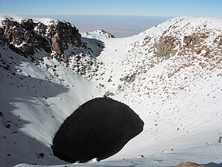
WLicancabur Lake is a crater lake in Chile located in the volcano Licancabur in the Antofagasta region, of the Región de Antofagasta, Province of El Loa. It is close to San Pedro de Atacama and also very close to the border of Chile with Bolivia. It is believed to be one of the highest lakes in the world at an elevation of 5,900 m (19,400 ft).
 W
WLake Llanquihue is the second-largest lake in Chile with an area of about 860 square kilometres (330 sq mi). It is situated in the southern Los Lagos Region in the Llanquihue and Osorno provinces. The lake's fan-like form was created by successive piedmont glaciers during the Quaternary glaciations. The last glacial period is called Llanquihue glaciation in Chile after the terminal moraine systems around the lake.
 W
WThe Maihue Lake is a lake located east of Ranco Lake in the Andean mountains of southern Chile. The lake is of glacial origin and it is enclosed by mountain ranges of the Andes, by all sides, and drains west to Ranco Lake.
 W
WLaguna del Maule is a lake located in the Andes of Central Chile. The lake is natural in origin, but its water level was raised by a dam inaugurated in 1957. It is located at 2,165 metres above sea level. It has a capacity of 1,420 million m³.
 W
WMiscanti Lake (Spanish: Laguna Miscanti) is a brackish water lake located in the altiplano of the Antofagasta Region, in northern Chile. Miñiques volcano and Cerro Miscanti tower over this lake. This heart-shaped lake has a deep blue color. The western shoreline of the lake is separated by less than 1 km from the drainage divide between the lake and the Salar de Atacama basins. Laguna Miscanti basin also has a common boundary with Salar de Talar basin.
 W
WNeltume Lake is one of the "Seven Lakes" in Panguipulli municipality, southern Chile. The lake is of glacial origin and it is enclosed by mountain ranges of the Andes. It is nearby the small town of Neltume that bears the same name.
 W
WThe Nordenskjöld is a lake in Torres del Paine National Park in the Magallanes Region, southern Chile. The lake is named after the Swede Otto Nordenskiöld who discovered the lake in the beginning of the 20th century. The outfall of Nordenskjöld Lake consists of a waterfall known as Salto Grande. At this western end of the lake on the southern side is an abundance of wildlife including wild grazing guanaco.
 W
WThe Panguipulli Lake is one of the "Seven Lakes" in Panguipulli municipality, southern Chile. The lake is of glacial origin and it is enclosed by mountain ranges of the Andes, on all sides except the west, where the town of Panguipulli lies in the Chilean Central Valley. The lake is drained by the Enco River that flows south to Riñihue Lake.
 W
WLake Pehoé is a surface water body located in Torres del Paine National Park, in the Magallanes Region of southern Chile. The lake is fed mainly by Paine River through the Nordenskjöld Lake, but it also receives the waters of the outlet of Skottsberg Lake.
 W
WThe Pellaifa Lake is one of the "Seven Lakes" in Panguipulli municipality, southern Chile. The lake is of glacial origin and lies in an area of hot springs.
 W
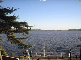
WPetrel Lake is a salt lake located in Pichilemu beach, Chile, in front of Pichilemu railway station.
 W
WPirihueico Lake is one of Seven Lakes in Panguipulli Commune, southern Chile. The lake is of glacial origin and it is enclosed mountains of the Andes. It is located in a geological fault that includes Panguipulli Lake and Lácar Lake in Argentina. The lake is drained by Fui River. Pirihueico Lake is used as a waterway due to its elonged shape. It is used mostly by vehicles traveling to or from Argentina by the nearby Huahum Pass. For that reason there is a ferry operating between Puerto Fuy and Puerto Pirihueico in the western respectively eastern extreme of the lake.
 W
WPresidente Ríos Lake is located in the Aysén del General Carlos Ibáñez del Campo Region of Chile. It lies in the middle of the Taitao Peninsula.
 W
WPuyehue Lake, is an Andean piedmont lake on the border of Los Lagos Region with Los Ríos Region of Chile.
 W
WRanco Lake is located in Ranco Province of Chile. It is the largest lake of Los Ríos Region and the fourth largest in Chile. Administratively Ranco Lake is split into three communes; La Unión, Futrono and Lago Ranco. The lake hosts a series of islands, of which Huapi Island is the largest. The western half of the lake is roughly circular while the eastern part features deep embayments. Geographically the lake lies in the Andean precordillera, the zone between the Chilean Central Valley and the Andes.
 W
WRapel Lake is an artificial lake created by a dam on the Rapel River. It is located in the Libertador General Bernardo O'Higgins Region, Central Chile.
 W
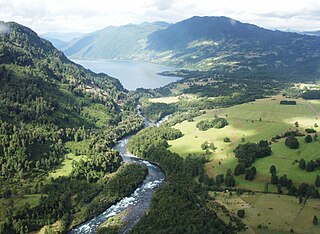
WThe Work is a lake of glacial origin in eastern Valdivia Province, southern Chile. It is surrounded by several mountains. The eastern side receives the waters of the Panguipulli Lake by the Enco River, its main contributor. It is the last of the Seven Lakes chain. In the west it is cut into two arms by the Tralcán Mount, and on the east side lies the Mocho-Choshuenco volcano. In the south the lake is bounded by the Cerros de Quimán mountains.
 W
WRupanco Lake is located in Los Lagos Region of Chile. The closest city, Osorno, has a primary school named after it as well.
 W
WSan Rafael Lake is an arc-shaped coastal lake located in the Aysén del General Carlos Ibáñez del Campo Region of Chile, within the national park that bears its name. To the north the lagoon is connected to the Moraleda Channel, to the south lies the Ofqui Isthmus. To the west and east lie the Taitao Peninsula and the Northern Patagonian Ice Field respectively.
 W
WSarmiento Lake is a lake located in Torres del Paine National Park, in the Magallanes Region of southern Chile. It is named after Spanish explorer Pedro Sarmiento de Gamboa, and gives its name to one of the areas in the National Park Torres del Paine. Its edge is marked by extensive calcium carbonate "Thrombolites" deposits, possibly from hydrothermal activity in the lake.
 W
WThe Seven Lakes is a group of lakes which belong to the same drainage basin that starts in the Lácar Lake and ends in Corral Bay.
 W
WTinquilco Lake is one of several lakes in Huerquehue National Park in the La Araucanía Region in southern Chile. Located at 700 meters; it is the first lake visitors encounter in the park before continuing on the "Tres Lagos" hike.
 W
WLake Todos los Santos is a lake located in the Los Lagos Region of southern Chile, 96 km northeast of the regional capital Puerto Montt and 76 km east of Puerto Varas, within the boundaries of the Vicente Pérez Rosales National Park. It has a surface area of 178.5 km² and a maximum depth of 337 m. The Lake's National Park status has ensured protection to its environment. The catchment is largely covered with old-growth Valdivian temperate rain forests. The present form of the lake is the result of glacial and volcanic processes.
 W
WDel Toro Lake is a lake located in the Magallanes Region, southern Chile. Also known as Lago del Toro or Lago Toro, its etymology comes from the lake's ability to generate 4 m swells due to a long (~30 km) fetch and high winds aligned with the long axis of the lake. Locals say that the lake and the nearby mountain Sierra del Toro is named thus because the lake 'is angry a lot'. Services on the lake include camping and fishing at Bahia el Bote.
 W
WTuyajto Lake is a salt lake located in the Antofagasta Region, northern Chile. Located at an elevation of about 4,010 metres (13,160 ft), its surface area presently fluctuates between 1.7–2.7 square kilometres (0.66–1.04 sq mi) but in the past it was considerably larger; this led to humans going to the lake and creating archeological sites there. Presently, the lake is groundwater-fed and has no surface outlet but water might seep out underground.
 W
WLaguna Verde is a salt lake in the Andes Mountains of Chile. It lies in the Atacama Region, near San Francisco Pass. The stratovolcano Ojos del Salado, on the border with Argentina, marks the south border of its basin.
 W
WLake Villarrica, also known as Mallalafquén, is located about 700 kilometers south of Santiago in Chile's Lake District in the southeast area of the Province of Cautín. On its east shore lies the city of Pucón, a major tourist attraction and a popular ski resort, and on the west shore lies the town of Villarrica.
 W
WVintter Lake or Palena Lake is a lake located in Patagonia which is shared by Argentina, where it is known as Lago General Vintter, and by Chile, where it's called Lago Palena. Both names are internationally accepted. The Argentine name is after General Lorenzo Vintter, the second governor of the Argentine Territory of Patagonia (1882–1884), and the first governor of the Territory of the Río Negro (1884–1888).
 W
WYelcho Lake is a large fjord-shaped lake located in Chilean Patagonia, in southern Palena province of Los Lagos Region, Chile. The lake receives the waters of the Futaleufu River at its southern tip, near the tiny settlement of Puerto Ramirez. The river then flows northward through mountainous and glaciated terrain, until it outflows via the Yelcho River north-west and empties into Gulf of Corcovado, near Chaitén. The lake is a popular destination for fly fishing, and several lodges and hotels operate on its shores. Yelcho Lake is most frequently accessed via the town of Chaitén to the north. Two small commercial airlines operate daily flights from Puerto Montt. Another option is ferry service direct from Puerto Montt, the bimodal ferry service from the town of Hornopiren, or direct from the port of Quellón on the island of Chiloe on the other side of the Gulf of Corcovado. Traffic on the Carretera Austral along the western shore of Yelcho Lake was interrupted in December 2017 due to a mudslide in the settlement of Villa Santa Lucía, which killed 22 people. The road reopened in February 2018.
 W
WYulton Lake, situated 4 km east of Cay Volcano and 15 km east of Maca Volcano, is a volcano-dammed lake in Aysén del General Carlos Ibáñez del Campo Region, Chile.