 W
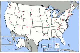
WThe elevation of the U.S. states, the federal district, and the territories may be described in several ways. These include:the elevation of their highest point; the elevation of their lowest point; and the difference between their highest points and lowest points.
 W
WMount Arvon, elevation 1,979 feet (603 m), located in L'Anse Township, Baraga County, is the highest natural point in the U.S. state of Michigan. Mount Arvon is part of the Huron Mountains. It rises about eight miles (13 km) south of Lake Superior. On the list of highest natural points in each U.S. state, Mount Arvon ranks 38th.
 W
WBlack Elk Peak is the highest natural point in South Dakota, United States. It lies in the Black Elk Wilderness area, in southern Pennington County, in the Black Hills National Forest. The peak lies 3.7 mi (6.0 km) west-southwest of Mount Rushmore. At 7,244 feet (2,208 m), it has been described by the Board on Geographical Names as the highest summit in the United States east of the Rocky Mountains. Though part of the North American Cordillera, it is generally considered to be geologically separate from the Rocky Mountains. Lost Mine peak in the Chisos Mountains of Texas, at an elevation of 7,535 feet, is the furthest east peak within the continental United States above 7,000 feet.
 W
WBlack Mesa is a mesa in the U.S. states of Colorado, New Mexico, and Oklahoma. It extends from Mesa de Maya, Colorado southeasterly 28 miles (45 km) along the north bank of the Cimarron River, crossing the northeast corner of New Mexico to end at the confluence of the Cimarron River and Carrizo Creek near Kenton in the Oklahoma panhandle. Its highest elevation is 5,705 feet (1,739 m) in Colorado. The highest point of Black Mesa within New Mexico is 5,239 feet (1,597 m). In northwestern Cimarron County, Oklahoma, Black Mesa reaches 4,973 feet (1,516 m), the highest point in the state of Oklahoma. The plateau that formed at the top of the mesa has been known as a "geological wonder" of North America. There is abundant wildlife in this shortgrass prairie environment, including mountain lions, butterflies, and the Texas horned lizard.
 W
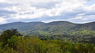
WBlack Mountain is the highest mountain peak in the Commonwealth of Kentucky, United States, with a summit elevation of 4,145 feet (1,263 m) above mean sea level and a top-to-bottom height of over 2,500 feet (760 m). The summit is located at approximately 36°54′51″N 82°53′38″W in Harlan County, Kentucky near the Virginia border, just above the towns of Lynch, Kentucky and Appalachia, Virginia. It is alternatively known as Katahrin's Mountain, and is about 500 feet (150 m) taller than any other mountain in Kentucky.
 W
WBorah Peak is the highest mountain in the U.S. state of Idaho and one of the most prominent peaks in the contiguous states. It is located in the central section of the Lost River Range, within the Challis National Forest in eastern Custer County.
 W
WBoundary Peak is a mountain in Esmeralda County, Nevada, United States. With a peak elevation of 13,147 feet (4,007 m), it is the highest natural point in the state of Nevada.
 W
WBrasstown Bald is the highest point in the U.S. state of Georgia. Located in northeast Georgia, the mountain is known to the native Cherokee people as Enotah.
 W
WBritton Hill is the highest natural point in the state of Florida, United States, with a summit elevation of 345 feet (105 m) above mean sea level. Britton Hill is the lowest state highpoint in the United States, 103 feet (31 m) lower than the next lowest highpoint, Ebright Azimuth in Delaware, and far lower than many skyscrapers in Miami and other urban areas of Florida.
 W
WCampbell Hill is, at 1,550 feet (470 m), the highest point in elevation in the U.S. state of Ohio. Campbell Hill is located within the city of Bellefontaine, 2 miles (3.2 km) northeast of downtown.
 W
WCharles Mound is a gentle, 1,235-foot (376 m) high hill in northern Jo Daviess County, Illinois, United States, near the small town of Scales Mound, and 11 miles (18 km) northeast of Galena. It is the highest natural point in the state; thus, it is considered a highpoint.
 W
WCheaha Mountain, often called Mount Cheaha, is the highest natural point in the U.S. state of Alabama. It is located a few miles northwest of the town of Delta in Cheaha State Park, which offers a lodge, a restaurant, and other amenities.
 W
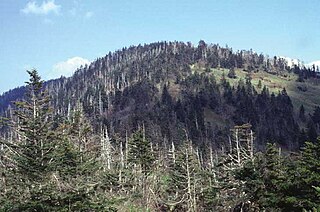
WClingmans Dome is a mountain in the Great Smoky Mountains of Tennessee and North Carolina, in the southeastern United States. At an elevation of 6,643 feet (2,025 m), it is the highest mountain in the Great Smoky Mountains National Park, the highest point in the state of Tennessee, and the highest point along the 2,192-mile (3,528 km) Appalachian Trail. It is also the third highest point in mainland Eastern North America, after the nearby Mount Mitchell and Mount Craig.
 W
WMount Davis is the highest point in Pennsylvania. Located in the 5,685-acre (2,301 ha) Forbes State Forest near the hamlet of Markleton in Elk Lick Township, Somerset County; it lies on a gentle crest of a 30-mile (50 km) ridge line extending from central Somerset County southward into Garrett County, Maryland known as Negro Mountain.
 W
WDenali is the highest mountain peak in North America, with a summit elevation of 20,310 feet (6,190 m) above sea level. With a topographic prominence of 20,156 feet (6,144 m) and a topographic isolation of 4,629 miles (7,450 km), Denali is the third most prominent and third most isolated peak on Earth, after Mount Everest and Aconcagua. Located in the Alaska Range in the interior of the U.S. state of Alaska, Denali is the centerpiece of Denali National Park and Preserve.
 W
WDriskill Mountain is the highest natural summit in Louisiana, with an elevation of 535 feet (163 m) above sea level. It lies about 5.3 miles (8.5 km) southeast of Bryceland, in Bienville Parish. A large pile of rocks marks the high point.
 W
WEagle Mountain is the highest natural point in Minnesota, United States, at 2,301 feet (701 m). It is in northern Cook County, in the Boundary Waters Canoe Area Wilderness and Superior National Forest in the Misquah Hills, northwest of Grand Marais. It is a Minnesota State Historic Site.
 W
WThe Ebright Azimuth is the point with the highest benchmark monument elevation in the U.S. state of Delaware. It is marked with a geodetic benchmark monument and has an elevation of 447.85 feet (136.50 m) above sea level. The only state high-point with a lower elevation is Britton Hill in the state of Florida at 345 feet (105 m) above sea level.
 W
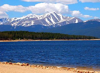
WMount Elbert is the highest summit of the Rocky Mountains of North America and the highest point in the U.S. state of Colorado and the entire Mississippi River drainage basin. The ultra-prominent 14,440-foot (4401.2 m) fourteener is the highest peak in the Sawatch Range and the second-highest summit in the contiguous United States after Mount Whitney. Mount Elbert is located in San Isabel National Forest, 12.1 miles (19.4 km) southwest of the City of Leadville in Lake County, Colorado.
 W
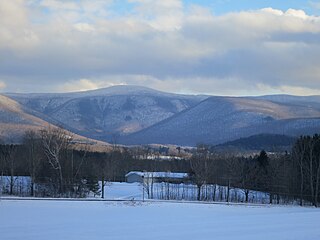
WMount Frissell, 2,454 feet (748 m), which straddles the border of southwest Massachusetts and northwest Connecticut, is a prominent peak of the Taconic Range.
 W
WGannett Peak is the highest mountain peak in the U.S. state of Wyoming at 13,810 feet (4,210 m). It lies in the Wind River Range within the Bridger Wilderness of the Bridger-Teton National Forest. Straddling the Continental Divide along the boundary between Fremont and Sublette counties, it has the second greatest topographic prominence in the state (7076') after Cloud Peak (7077'), and is the highest ground for 290.36 miles in any direction.
 W
WGranite Peak, at an elevation of 12,807 feet (3,904 m) above sea level, is the highest natural point in the U.S. state of Montana, and the tenth-highest state high point in the nation. It lies within the Absaroka-Beartooth Wilderness in Park County, very near the borders of Stillwater County and Carbon County. Granite Peak is 10 miles (16 km) north of the Wyoming border and 45 miles (72 km) southwest of Columbus, Montana.
 W
WMount Greylock is a 3,489 feet (1,063 m) mountain located in the northwest corner of Massachusetts and is the highest point in the state. Its summit is in the western part of the town of Adams in Berkshire County. Although technically it is geologically part of the Taconic Mountains, Mount Greylock is commonly associated with the abutting Berkshire Mountains to the east. The mountain is known for its expansive views encompassing five states and the only taiga-boreal forest in the state. A seasonal automobile road climbs to the summit, topped by a 93-foot-high (28 m) lighthouse-like Massachusetts Veterans War Memorial Tower. A network of hiking trails traverse the mountain, including the Appalachian Trail. Mount Greylock State Reservation was created in 1898 as Massachusetts' first public land for the purpose of forest preservation.
 W
WGuadalupe Peak, also known as Signal Peak, is the highest natural point in Texas, with an elevation of 8,751 feet (2,667 m) above sea level. It is located in Guadalupe Mountains National Park, and is part of the Guadalupe Mountains range in southeastern New Mexico and West Texas. The mountain is about 90 miles (140 km) east of El Paso and about 50 miles (80 km) southwest of Carlsbad, New Mexico. The peak rises more than 3,000 feet (910 m) above the arid floor of the Chihuahuan Desert.
 W
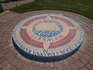
WHawkeye Point is the highest natural point in Iowa at 1,670 feet (510 m). It is approximately 4.5 miles (7.2 km) north of Sibley on the eastern side of SR 60 and approximately 3.5 miles (5.6 km) south of the Iowa-Minnesota state border. The high ground lies 100 feet (30 m) due south of an old silo.
 W
WHigh Point is a mountain peak within High Point State Park on the border of Wantage Township and Montague Township, Sussex County, New Jersey, United States. Located in the portion of the state known as the Skylands, it is the highest elevation in the state, with a peak elevation of 1,803 feet. The closest city is Port Jervis, New York, which lies to the northwest. Besides being the highest peak in New Jersey, High Point is also the highest peak of the Kittatinny Mountains. Three states – New Jersey, New York, and Pennsylvania – can be seen from the summit.
 W
WMount Hood is a potentially active stratovolcano in the Cascade Volcanic Arc. It was formed by a subduction zone on the Pacific coast and rests in the Pacific Northwest region of the United States. It is located about 50 miles (80 km) east-southeast of Portland, on the border between Clackamas and Hood River counties. In addition to being Oregon's highest mountain, it is one of the loftiest mountains in the nation based on its prominence, and it offers the only year-round lift-served skiing in North America.
 W
WHoosier Hill is the highest natural point in the state of Indiana at 1,257 feet (383 m) above sea level. It is in the rural area of Franklin Township, Wayne County to the northwest of Bethel. The nearest intersection to the high point is Elliot Road and County Line Road. The nearest major landmark is Interstate 70 and Richmond 11 miles (17.5 km) to the south.
 W
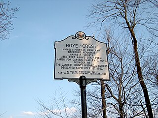
WHoye-Crest is a summit along Backbone Mountain just inside of Garrett County, Maryland. It is the highest natural point in Maryland at an elevation of 3,360 feet (1,020 m).
 W
WHumphreys Peak is the highest natural point and the second most prominent peak after Mount Graham in the U.S. state of Arizona, with an elevation of 12,637 feet (3,852 m) and is located within the Kachina Peaks Wilderness in the Coconino National Forest, about 11 miles (17.7 km) north of Flagstaff, Arizona. Humphreys Peak is the highest of a group of dormant volcanic peaks known as the San Francisco Peaks.
 W
WJerimoth Hill is the highest point in the U.S. state of Rhode Island. Located in the town of Foster in the northwest of the state, the site is used as an observatory. It is also a popular destination for highpointers, and prior to 2005 was known for being difficult to access due to a local landowner who prohibited entry.
 W
WMount Katahdin is the highest mountain in the U.S. state of Maine at 5,269 feet (1,606 m). Named Katahdin by the Penobscot Native Americans, which means "The Greatest Mountain", it is located within Northeast Piscataquis, Piscataquis County, and is the centerpiece of Baxter State Park. It is a steep, tall massif formed from a granite intrusion weathered to the surface. The flora and fauna on the mountain are typical of those found in northern New England.
 W
WKings Peak is the highest peak in the U.S. state of Utah, with an elevation of 13,534 feet (4,125 m) NAVD 88.
 W
WMount Magazine, officially named Magazine Mountain, is the highest point of the U.S. Interior Highlands and the U.S. state of Arkansas, and is the site of Mount Magazine State Park. It is a flat-topped mountain or mesa capped by hard rock and rimmed by precipitous cliffs. There are two summits atop the mountain: Signal Hill, which reaches 2,753 feet (839 m), and Mossback Ridge, which reaches 2,700 ft (823.0 m).
 W
WMount Mansfield is the highest mountain in Vermont with a summit that peaks at 4,395 feet (1,340 m) above sea level. The summit is located within the town of Underhill in Chittenden County; the ridgeline, including some secondary peaks, extends into the town of Stowe in Lamoille County, and the mountain's flanks also reach into the town of Cambridge.
 W
WMount Marcy is the highest point in New York, with an elevation of 5,344 feet (1,629 m). It is located in the Town of Keene in Essex County. The mountain is in the heart of the Adirondack High Peaks region of the High Peaks Wilderness Area. Its stature and expansive views make it a popular destination for hikers, who crowd its summit in the summer months.
 W
WMauna Kea is a dormant volcano on the island of Hawaiʻi. Its peak is 4,207.3 m (13,803 ft) above sea level, making it the highest point in the state of Hawaiʻi. Most of the volcano is underwater, and when measured from its underwater base, Mauna Kea is the tallest mountain in the world, measuring 10,211 m (33,500 ft) in height. Mauna Kea is about a million years old, and has thus passed the most active shield stage of life hundreds of thousands of years ago. In its current post-shield state, its lava is more viscous, resulting in a steeper profile. Late volcanism has also given it a much rougher appearance than its neighboring volcanoes due to construction of cinder cones, decentralization of its rift zones, glaciation on its peak, and weathering by the prevailing trade winds. Mauna Kea last erupted 6,000 to 4,000 years ago and is now considered dormant. The peak is about 38 m (125 ft) higher than Mauna Loa, its more massive neighbor.
 W
WMount Mitchell, known in Cherokee as Attakulla, is the highest peak of the Appalachian Mountains and the highest peak in mainland eastern North America. It is located near Burnsville in Yancey County, North Carolina; in the Black Mountain subrange of the Appalachians, about 19 miles (31 km) northeast of Asheville. It is protected by Mount Mitchell State Park and surrounded by the Pisgah National Forest. Mount Mitchell's elevation is 6,684 feet (2,037 m) above sea level.
 W
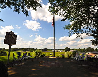
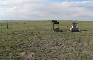
WPanorama Point also known as Constable Mountain, is the highest natural point in Nebraska, at an elevation of 5,429 feet (1,655 m) above sea level. It is located in southwestern Kimball County, near the point where Nebraska and Wyoming meet on Colorado's northern boundary. Despite its name and elevation, Panorama Point is not a mountain or a hill; it is merely a low rise on the High Plains. A stone marker, giving the elevation at 5,424 feet (1,653 m), and a guest register are located at the summit of the drive. From the point one can see the nearby state corner marker, and a vast plains landscape with the Rocky Mountains in the western distance. Panorama Point is located on the High Point Bison Ranch, which permits visitors to drive to the site as long as they take care to avoid the ranging bison and pay an entrance fee.
 W
WMount Rainier, also known as Tahoma or Tacoma, is a large active stratovolcano in the Cascade Range of the Pacific Northwest, located in Mount Rainier National Park about 59 miles (95 km) south-southeast of Seattle. With a summit elevation of 14,411 ft (4,392 m), it is the highest mountain in the U.S. state of Washington and the Cascade Range, the most topographically prominent mountain in the contiguous United States, and the tallest in the Cascade Volcanic Arc.
 W
WMount Rogers is the highest natural point in Virginia, United States, with a summit elevation of 5,729 feet (1,746 m) above mean sea level. The summit straddles the border of Grayson and Smyth Counties, Virginia, about 6.45 miles (10.38 km) WSW of Troutdale, Virginia. Most of the mountain is contained within the Lewis Fork Wilderness, while the entire area is part of the Mount Rogers National Recreation Area, which itself is a part of the Jefferson National Forest.
 W
WSassafras Mountain is the highest point in the state of South Carolina, United States. It is in the Blue Ridge Mountains, part of the Appalachian Mountains. An observation tower opened on top of Sassafras Mountain in 2019.
 W
WSpruce Knob, at 4,863 feet (1,482 m), is the highest point in the state of West Virginia and the summit of Spruce Mountain, the highest peak in the Allegheny Mountains.
 W
WMount Sunflower, although not a true mountain, is the highest natural point in the state of Kansas. At 4,039 feet (1,231 m), it is 3,300 feet (1,010 m) above the state's topographic low point, which lies on the opposite side of the state. Located in Wallace County, it is less than half a mile (0.8 km) from the Colorado state border and close to the lowest point in Colorado.
 W
WTaum Sauk Mountain in the Saint Francois Mountains is the highest natural point in the U.S. state of Missouri at 1,772 feet . The topography of Taum Sauk is that of an elongated ridge with a NNW-SSE orientation rather than a peak.
 W
WTimms Hill is the highest natural point in the U.S. state of Wisconsin. Located in north-central Wisconsin in Timms Hill County Park in the Town of Hill in Price County, Timms Hill has an elevation of 1,951.5 ft (595 m). It is less than 1 mile (1.6 km) south of Highway 86, about midway between Ogema and Spirit and about 23 miles (37 km) west of Tomahawk.
 W
WMount Washington, called Agiocochook by some Native American tribes, is the highest peak in the Northeastern United States at 6,288.2 ft (1,916.6 m) and the most topographically prominent mountain east of the Mississippi River.
 W
WWheeler Peak is the highest natural point in the U.S. state of New Mexico. It is located northeast of Taos and south of Red River in the northern part of the state, and just 2 miles (3.2 km) southeast of the ski slopes of Taos Ski Valley. It lies in the Sangre de Cristo Mountains, the southernmost subrange of the Rocky Mountains. The peak's elevation is 13,167 feet (4,013 m).
 W
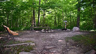
WWhite Butte is the highest natural point in the U.S. state of North Dakota. At an elevation of 3,506 ft, it is a prominent butte in Slope County, in the Badlands of the southwestern part of the state. It is located 3 miles east of U.S. 85 and about 6.5 mi (10 km) south of Amidon.
 W
WMount Whitney is the tallest mountain in the contiguous United States and the Sierra Nevada, with an elevation of 14,505 feet (4,421 m). It is in East–Central California, on the boundary between California's Inyo and Tulare counties, 84.6 miles (136.2 km) west-northwest of North America's lowest point, Badwater Basin in Death Valley National Park, at 282 ft (86 m) below sea level. The mountain's west slope is in Sequoia National Park and the summit is the southern terminus of the John Muir Trail, which runs 211.9 mi (341.0 km) from Happy Isles in Yosemite Valley. The eastern slopes are in Inyo National Forest in Inyo County.
 W
WWoodall Mountain is the highest natural point in the U.S. state of Mississippi at 807 feet. It is located just off Mississippi Highway 25, south of Iuka in Tishomingo County in the northeast part of the state.