 W
WThe Atacama Desert is a desert plateau in South America covering a 1,600 km (990 mi) strip of land on the Pacific coast, west of the Andes Mountains. The Atacama Desert is the driest nonpolar desert in the world, as well as the only true desert to receive less precipitation than the polar deserts and the largest fog desert in the world. Both regions have been used as experimentation sites on Earth for Mars expedition simulations. According to estimates, the Atacama Desert occupies 105,000 km2 (41,000 sq mi), or 128,000 km2 (49,000 sq mi) if the barren lower slopes of the Andes are included. Most of the desert is composed of stony terrain, salt lakes (salares), sand, and felsic lava that flows towards the Andes.
The 4 Deserts Ultramarathon Series is an annual series of four 250-kilometer (155-mile) races across deserts around the globe. The races were recognized as the world's leading endurance footrace series by TIME magazine in 2009 and 2010, as the "Ultimate test of human endurance". The series was founded by American Mary K Gadams who founded RacingThePlanet in 2002.
 W
WAlto Loa National Reserve is a Protected Area located in the province of El Loa, Antofagasta region, Chile. Announced in 2002 and created in 2005, it is Chile's largest natural reserve.
 W
WArica is a commune and a port city with a population of 222,619 in the Arica Province of northern Chile's Arica y Parinacota Region. It is Chile's northernmost city, being located only 18 km (11 mi) south of the border with Peru. The city is the capital of both the Arica Province and the Arica and Parinacota Region. Arica has a mild, temperate climate with some of the lowest annual rainfall rates anywhere in the world. Arica is located at the bend of South America's western coast known as the Arica Bend or Arica Elbow. At the location of the city are two lush valleys that dissect the Atacama Desert converge: Azapa and Lluta. These valleys provide fruit for export.
 W
WThe Atacama Fault Zone (AFZ) is an extensive system of faults cutting across the Chilean Coastal Cordillera in Northern Chile between the Andean Mountain range and the Pacific Ocean. The fault system is North-South striking and runs for more than 1100 km North and up to 50 km in width through the Andean forearc region. The zone is a direct result of the ongoing subduction of the Eastward moving Nazca Plate beneath the South American Plate and is believed to have formed in the Early Jurassic during the beginnings of the Andean orogeny. The zone can be split into 3 regions: the North, Central and South.
 W
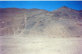
WThe Atacama Giant is an anthropomorphic geoglyph on Cerro Unitas in the Atacama Desert, Chile. It is the largest prehistoric anthropomorphic figure in the world with a length of 119 metres (390 ft), and represented a deity for the local inhabitants from AD 1000 to 1400.
 W
WThe Atacama Large Millimeter/submillimeter Array (ALMA) is an astronomical interferometer of 66 radio telescopes in the Atacama Desert of northern Chile, which observe electromagnetic radiation at millimeter and submillimeter wavelengths. The array has been constructed on the 5,000 m (16,000 ft) elevation Chajnantor plateau - near the Llano de Chajnantor Observatory and the Atacama Pathfinder Experiment. This location was chosen for its high elevation and low humidity, factors which are crucial to reduce noise and decrease signal attenuation due to Earth's atmosphere. ALMA is expected to provide insight on star birth during the early Stelliferous era and detailed imaging of local star and planet formation.
 W
WThe Atacama people, known as atacameños or atacamas in Spanish and Kunzas, Likan-antai or Likanantaí in English, are indigenous people from the Atacama Desert and altiplano region in the north of Chile and Argentina and southern Bolivia.
 W
WThe Atacama Submillimeter Telescope Experiment (ASTE) is a 10m antenna built by Mitsubishi Electric as a preprototype for ALMA.
 W
WThe Atacama B-Mode Search (ABS) was an experiment to test the theory of cosmic inflation and distinguish between inflationary models of the very early universe by making precise measurements of the polarization of the Cosmic Microwave Background (CMB). ABS was located at a high-altitude site in the Atacama Desert of Chile as part of the Parque Astronómico de Atacama. ABS began observations in February 2012 and completed observations in October 2014.
 W
WThe Battle of Río Grande was a small military engagement that took place on 10 September 1879, during the War of the Pacific. A picket of Chilean soldiers and a Bolivian montonera clashed in Rio Grande, around San Pedro de Atacama. Bolivians are defeated, which eliminates local resistance to Chilean occupation in the Litoral Department.
 W
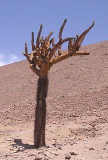
WBrowningia candelaris is a species of cactus from northern Chile and southern Peru. It has a distinctive growth habit, with a straight spiny trunk topped by more-or-less spineless thinner branches. In some places, the long-term survival of local populations may be threatened by grazing, which destroys seedlings.
 W
WThe Cerro Chajnantor Atacama Telescope (CCAT) is a proposed 25 metres (82 ft) diameter telescope that is intended to reveal the cosmic origins of stars, planets, and galaxies with its submillimeter cameras and spectrometers enabled by superconducting detector arrays. The telescope was originally called the Cornell Caltech Atacama Telescope.
 W
WChacabuco is one of the many abandoned nitrate or "saltpeter" towns in the Atacama Desert of northern Chile. Other nitrate towns of the Atacama Desert include Humberstone and Santa Laura Saltpeter Works. Unlike most of the other ghost towns in the Atacama Desert, Chacabuco became a concentration camp during the Pinochet regime in 1973. To this day, it remains surrounded by approximately 98 lost landmines, left by the Chilean military when Chacabuco was used as a prison camp.
 W
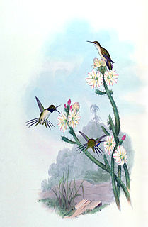
WThe Chilean woodstar is a small bird in the hummingbird family, Trochilidae. It is restricted to northernmost Chile with reports from southern Peru. Its natural habitats are dry shrubland and rural gardens. It is threatened by habitat loss and is classed as a critically endangered species. It is usually classified in its own genus Eulidia, but is sometimes placed with the purple-collared woodstar in the genus Myrtis. In 2013, it was classed as endangered, but recently, it was classed as critically endangered by the IUCN Red List.
 W
WChuquicamata is the largest open pit copper mine by excavated volume in the world. It is located in the north of Chile, just outside Calama at 2,850 m (9,350 ft) above sea level, 215 km (134 mi) northeast of Antofagasta and 1,240 km (770 mi) north of the capital, Santiago. Flotation and smelting facilities were installed in 1952, and expansion of the refining facilities in 1968 made 500,000 ton annual copper production possible in the late 1970s. Previously part of Anaconda Copper, the mine is now owned and operated by Codelco, a Chilean state enterprise, since the Chilean nationalization of copper in the late 1960s and early 1970s. Its depth of 850 metres (2,790 ft) makes it the second deepest open-pit mine in the world after Bingham Canyon Mine in Utah, United States.
 W
WCopiapó is a city in northern Chile, located about 65 kilometers east of the coastal town of Caldera. Founded on December 8, 1744, it is the capital of Copiapó Province and Atacama Region.
 W
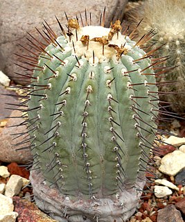
WCopiapoa is a genus of flowering plants in the cactus family Cactaceae, from the dry coastal deserts, particularly the Atacama Desert, of northern Chile. It comprises 32 morphologically defined species and 5 heterotypic subspecies. These species vary in form from spherical to slightly columnar and in color from a brownish to blue-green body. They have warty ribs and spiny areoles, and they usually produce tubular yellow flowers which grow from woolly crowns in summer.
 W
WCopiapoa cinerea is a species of the genus Copiapoa in the family of Cactaceae. The epithet cinerea comes from the Latin word for ash, by reference to the colour of the epidermis.
 W
WCopiapoa echinoides is a species of cactus in South America.
 W
WCopiapoa marginata is a species of clump-forming cactus of South America.
 W
WThe Atacama Cosmology Telescope (ACT) is a six-metre telescope on Cerro Toco in the Atacama Desert in the north of Chile, near the Llano de Chajnantor Observatory. It is designed to make high-resolution, microwave-wavelength surveys of the sky in order to study the cosmic microwave background radiation (CMB). At an altitude of 5,190 metres (17,030 ft), it is one of the highest permanent, ground-based telescopes in the world.
 W
W(Phyllotis darwini) is a species of rodent in the family Cricetidae.
 W
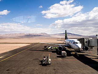
WDesierto de Atacama Airport is an airport serving the region around Copiapó, the capital of the Atacama Region of Chile. The airport is in the desert north of the Copiapó River, 16 kilometres (9.9 mi) inland from the Pacific coast.
 W
WEchinopsis atacamensis (cardón) is a species of cactus from Chile, Argentina and Bolivia. The wood of this species can be used in building and in making furniture.
 W
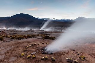
WEl Tatio is a geyser field located in the Andes Mountains of northern Chile at 4,320 metres (14,170 ft) above mean sea level. Various etymologies have been proposed for the name "El Tatio", which might mean "oven" or "grandfather". It is the third-largest geyser field in the world and the largest in the Southern Hemisphere.
 W
WEscondida is a copper mine at 3,100 metres (10,200 ft) elevation in the Atacama Desert in Antofagasta Region, Chile.
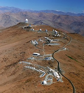
The European Organisation for Astronomical Research in the Southern Hemisphere, commonly referred to as the European Southern Observatory (ESO), is a 16-nation intergovernmental research organisation for ground-based astronomy. Created in 1962, ESO has provided astronomers with state-of-the-art research facilities and access to the southern sky. The organisation employs about 730 staff members and receives annual member state contributions of approximately €162 million. Its observatories are located in northern Chile.
 W
WFreirina is a Chilean commune and town in Huasco Province, Atacama Region. The commune spans an area of 3,577.7 km2 (1,381 sq mi).
 W
WGeoffroea decorticans, the chañar, kumbaru, or Chilean palo verde, is a small deciduous tree, up to 8 meters (25 ft) tall that inhabits most arid forests of southern South America. The chañar is cold and drought deciduous; it loses its leaves in winter, and possibly in summer if conditions get too dry. It is natural to Bolivia, Chile, Argentina, also present in Paraguay and southern Peru. It is a very characteristic tree in local culture and folk because of its vivid visual presence, propagation, and ancient ethnomedical uses.
 W
WHumberstone and Santa Laura Saltpeter Works are two former saltpeter refineries located in northern Chile. They were declared a UNESCO World Heritage Site in 2005.
 W
WLa Silla Observatory is an astronomical observatory in Chile with three telescopes built and operated by the European Southern Observatory (ESO). Several other telescopes are located at the site and are partly maintained by ESO. The observatory is one of the largest in the Southern Hemisphere and was the first in Chile to be used by ESO.
 W
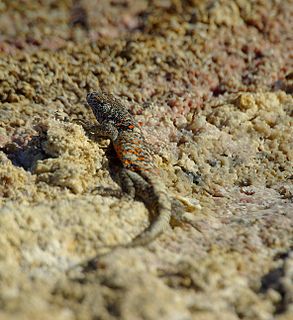
WLiolaemus atacamensis is a species of lizard in the family Iguanidae. It is endemic to Chile, with occurrence noted in the Chilean matorral.
 W
WLiolaemus fabiani, commonly known as Yanez's tree iguana and Fabian's lizard, is a species of lizard in the genus Liolaemus in the family Liolaemidae.
 W
WThe use of Nitratine or Chilean Saltpeter once an important source of nitrates for fertilizer and other chemical uses including gunpowder and fireworks.
 W
WLlano de Chajnantor Observatory is the name for a group of astronomical observatories located at an altitude of over 4,800 m (15,700 ft) in the Atacama Desert of northern Chile. The site is in the Antofagasta Region approximately 50 kilometres (31 mi) east of the town of San Pedro de Atacama. The exceptionally arid climate of the area is inhospitable to humans, but creates an excellent location for millimeter, submillimeter, and mid-infrared astronomy. This is because water vapour absorbs and attenuates submillimetre radiation. Llano de Chajnantor is home to the largest and most expensive astronomical telescope project in the world, the Atacama Large Millimeter Array (ALMA). Llano de Chajnantor and the surrounding area has been designated as the Chajnantor Science Reserve by the government of Chile.
 W
WLlullaillaco is a dormant stratovolcano at the border of Argentina and Chile. It lies in the Puna de Atacama, a region of tall volcanic peaks on a high plateau close to the Atacama Desert, one of the driest places in the world. It is the second highest active volcano in the world after Ojos del Salado.
 W
WLomas, also called fog oases and mist oases, are areas of fog-watered vegetation in the coastal desert of Peru and northern Chile. About 100 lomas near the Pacific Ocean are identified between 5°S and 30°S latitude, a north-south distance of about 2,800 kilometres (1,700 mi). Lomas range in size from a small vegetated area to more than 40,000 hectares and their flora includes many endemic species. Apart from river valleys and the lomas the coastal desert is almost without vegetation. Scholars have described individual lomas as "an island of vegetation in a virtual ocean of desert."
 W
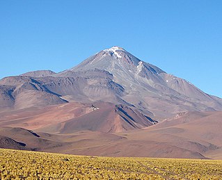
WNevado Ojos del Salado is an active stratovolcano in the Andes on the Argentina–Chile border and the highest active volcano in the world at 6,893 m (22,615 ft). It is also the second highest mountain in both the Western Hemisphere and the Southern Hemisphere behind Aconcagua at approximately 7,000 meters and it is the highest in Chile. Nevado Ojos del Salado could be translated as "Eyes of the Salty One", which describes it as being very snowy in the winter and salty with many lakes.
 W
WPampa del Tamarugal National Reserve is a nature reserve of northern Chile's Tarapacá Region located in the Pampa del Tamarugal, about 70 km (43 mi) east of Iquique. The reserve consists of three separate sectors: Zapiga, Bosque Nativo de La Tirana, and Pintados. The major highlights are the artificially planted forests of the genus Prosopis, found in the middle of a rainless desert, and the Pintados geoglyphs.
 W
WPan de Azúcar National Park is a national park of Chile. The park straddles the border between the Antofagasta Region and the Atacama Region. Its name, Parque Nacional Pan de Azúcar, means "sugar loaf national park".
 W
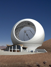
WParanal Observatory is an astronomical observatory operated by the European Southern Observatory (ESO). It is located in the Atacama Desert of northern Chile on Cerro Paranal at 2,635 m (8,645 ft) altitude, 120 km (70 mi) south of Antofagasta. By total light-collecting area, it is the largest optical-infrared observatory in the Southern Hemisphere; worldwide, it is second to the Mauna Kea Observatory on Hawaii.
 W
WThe Puna de Atacama or Atacama Plateau is an arid high plateau, in the Andes of northern Chile (15%) and Argentina (85%). Geomorphologist Walther Penck based his Grossfalt landform association on Puna de Atacama.
 W
WThe Purico complex is a Pleistocene volcanic complex in Chile close to Bolivia, formed by an ignimbrite, several lava domes and stratovolcanoes and one maar. It is one of the Chilean volcanoes of the Andes, and more specifically the Chilean segment of the Central Volcanic Zone, one of the four volcanic belts which make up the Andean Volcanic Belt. The Central Volcanic Zone spans Peru, Bolivia, Chile and Argentina and includes 44 active volcanoes as well as the Altiplano-Puna volcanic complex, a system of large calderas and ignimbrites of which Purico is a member of. Licancabur to the north, La Pacana southeast and Guayaques to the east are separate volcanic systems.
 W
WRhinella atacamensis, sometimes called the Vallenar toad or Atacama toad, is a species of toad in the family Bufonidae. It is endemic to Chile and occurs between Paposo and Las Chilcas. It inhabits the desert Pacific coastal region with Mediterranean influences and is found in and near oases and streams. Breeding takes place in permanent pools, streams, and rivers. While abundant at a few sites, it has declined overall and gone locally extinct at some sites. Threats to this species include extensive droughts and water pollution as well as extraction of surface water, mining, agriculture, livestock farming, and timber plantations.
 W
WSalar de Atacama is the largest salt flat in Chile. It is located 55 km (34 mi) south of San Pedro de Atacama, is surrounded by mountains, and has no drainage outlets. In the east it is enclosed by the main chain of the Andes, while to the west lies a secondary mountain range of the Andes called Cordillera de Domeyko. Large volcanoes dominate the landscape, including the Licancabur, Acamarachi, Aguas Calientes and the Láscar. The last is one of the most active volcanoes in Chile. All of them are located along the eastern side of the Salar de Atacama, forming a generally north-south trending line of volcanoes that separate it from smaller endorheic basins.
 W
WSan Pedro de Atacama is a Chilean town and commune in El Loa Province, Antofagasta Region. It is located east of Antofagasta, some 106 km (60 mi) southeast of Calama and the Chuquicamata copper mine, overlooking the Licancabur volcano. It features a significant archeological museum, the R. P. Gustavo Le Paige Archaeological Museum, with a large collection of relics and artifacts from the region. Native ruins nearby now attract increasing numbers of tourists interested in learning about pre-Columbian cultures.
 W
WAta is the common name given to the 6-inch (15 cm) long skeletal remains of a human fetus found in 2003 in a deserted Chilean town in the Atacama Desert. DNA analysis done in 2018 on the premature human fetus identified unusual mutations associated with dwarfism and scoliosis, though these findings were later disputed. The remains were found by Oscar Muñoz, who later sold them; the current owner is Ramón Navia-Osorio, a Spanish businessman.
 W
WUniversity of Atacama or UDA is a university in Chile. It is part of the Chilean Traditional Universities. UDA is in Copiapó, in the Third Region, Atacama.
 W
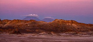
WEl Valle de la Luna is located 13 kilometres (8 mi) west of San Pedro de Atacama, to the north of Chile in the Cordillera de la Sal, in the Atacama desert. It has various stone and sand formations which have been carved by wind and water. It has an impressive range of color and texture, looking somewhat similar to the surface of the moon. There are also dry lakes where the composition of salt makes a white covering layer of the area. It presents diverse saline outcrops which appear like man-made sculptures. There are also a great variety of caverns. When the sun sinks it defines the landscape while the wind blows among the rocks and the sky passes from pink color to purple and finally black. Valle de la Luna is a part of the Reserva Nacional los Flamencos and was declared a Nature Sanctuary in 1982 for its natural environment and strange lunar landscape, from which its name is derived. The Atacama desert is also considered one of the driest places on earth, as some areas have not received a single drop of rain in hundreds of years. A prototype for a Mars rover was tested there by scientists because of the valley's dry and forbidding terrains.
 W
WVallenar is a city and commune in Atacama Region, Chile. It is the capital of the Huasco Province and is located in the valley of the Huasco River. Vallenar has 52,000 inhabitants. Its main activities are farming and mining. It was founded as San Ambrosio de Ballenary by Ambrose O'Higgins in 1789, after his birthplace in Ballynary in County Sligo, Ireland.