 W
WLimnology, is the study of inland aquatic ecosystems. The study of limnology includes aspects of the biological, chemical, physical, and geological characteristics and functions of inland waters. This includes the study of lakes, reservoirs, ponds, rivers, springs, streams, wetlands, and groundwater. A more recent sub-discipline of limnology, termed landscape limnology, studies, manages, and seeks to conserve these ecosystems using a landscape perspective, by explicitly examining connections between an aquatic ecosystem and its drainage basin. Recently, the need to understand global inland waters as part of the Earth System created a sub-discipline called global limnology. This approach considers processes in inland waters on a global scale, like the role of inland aquatic ecosystems in global biogeochemical cycles.
 W
W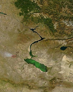 W
WAn ancient lake is a lake that has consistently carried water for more than one million years. Many have existed for more than 2.6 million years, the full Quaternary period. Ancient lakes continue to persist due to plate tectonics in an active rift zone. This active rift zone creates lakes that are extremely deep and difficult to naturally fill with sediment. Due to the prolonged life of ancient lakes, they serve as models for isolated evolutionary traits and speciation. Most of the world's bodies of water are less than 18,000 years old. There are only 20 ancient lakes over 1 million years old.
 W
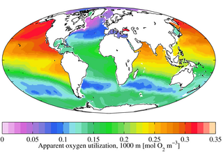
WIn freshwater or marine systems apparent oxygen utilization (AOU) is the difference between oxygen gas solubility and the measured oxygen concentration in water with the same physical and chemical properties. Such differences typically occur when biological activity acts to change the ambient concentration of oxygen. For example, primary production liberates oxygen and increases its concentration, while respiration consumes it and decreases its concentration.
 W
WIn geography, a bank is the land alongside a body of water. Different structures are referred to as banks in different fields of geography, as follows.
 W
WBioturbation is defined as the reworking of soils and sediments by animals or plants. These include burrowing, ingestion, and defecation of sediment grains. Bioturbating activities have a profound effect on the environment and are thought to be a primary driver of biodiversity. The formal study of bioturbation began in the 1800s by Charles Darwin experimenting in his garden. The disruption of aquatic sediments and terrestrial soils through bioturbating activities provides significant ecosystem services. These include the alteration of nutrients in aquatic sediment and overlying water, shelter to other species in the form of burrows in terrestrial and water ecosystems, and soil production on land.
 W
WA Bjerrum plot (named after Niels Bjerrum) is a graph of the concentrations of the different species of a polyprotic acid in a solution, as a function of pH, when the solution is at equilibrium. Due to the many orders of magnitude spanned by the concentrations, they are commonly plotted on a logarithmic scale. Sometimes the ratios of the concentrations are plotted rather than the actual concentrations. Occasionally H+ and OH− are also plotted.
 W
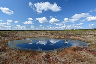
WA bog or bogland is a wetland that accumulates peat, a deposit of dead plant material—often mosses, and in a majority of cases, sphagnum moss. It is one of the four main types of wetlands. Other names for bogs include mire, mosses, quagmire, and muskeg; alkaline mires are called fens. A baygall is another type of bog found in the forest of the Gulf Coast states in the USA. they are often covered in heath or heather shrubs rooted in the sphagnum moss and peat. The gradual accumulation of decayed plant material in a bog functions as a carbon sink.
 W
WBraid bars, or mid-channel bars, are river landforms typically present in braided river channels. These formations have many names, including medial, longitudinal, crescentic, and transverse bars, as well as the more colloquial sandflat. Braid bars are distinguished from point bars due to their presence in the middle of a flow channel, rather than along a bank of the river channel.
 W
WA CTD or Sonde is an oceanography instrument used to measure the conductivity, temperature, and pressure of seawater. The reason to measure conductivity is that it can be used to determine the salinity.
 W
WA cut bank, also known as a river cliff or river-cut cliff, is the outside bank of a water channel (stream), which is continually undergoing erosion. Cut banks are found in abundance along mature or meandering streams, they are located on the outside of a stream bend, known as a meander, opposite the slip-off slope on the inside of the bend. They are shaped much like a small cliff, and are formed by the erosion of soil as the stream collides with the river bank. As opposed to a point bar, which is an area of deposition, a cut bank is an area of erosion.
 W
WIn geomorphology, drainage systems, also known as river systems, are the patterns formed by the streams, rivers, and lakes in a particular drainage basin. They are governed by the topography of the land, whether a particular region is dominated by hard or soft rocks, and the gradient of the land. Geomorphologists and hydrologists often view streams as part of drainage basins. This is the topographic region from which a stream receives runoff, throughflow, and its saturated equivalent, groundwater flow. The number, size, and shape of the drainage basins varies and the larger and more detailed the topographic map, the more information is available.
 W
WDystrophic lakes, also known as humic lakes, are lakes that contain high amounts of humic substances and organic acids. The presence of these substances causes the water to be brown in colour and have a generally low pH of around 4.0-6.0. Due to these acidic conditions, there is little biodiversity able to survive, consisting mostly of algae, phytoplankton, picoplankton, and bacteria. Ample research has been performed on the many dystrophic lakes located in Eastern Poland, but dystrophic lakes can be found in many areas of the world.
 W
WThe epilimnion or surface layer is the top-most layer in a thermally stratified lake, occurring above the deeper hypolimnion. It is warmer and typically has a higher pH and higher dissolved oxygen concentration than the hypolimnion.
 W
WIISD Experimental Lakes Area is an internationally unique research station encompassing 58 formerly pristine freshwater lakes in Kenora District Ontario, Canada. Previously run by Fisheries and Oceans Canada, after being de-funded by the Canadian Federal Government, the facility is now managed and operated by the International Institute for Sustainable Development (IISD) and has a mandate to investigate the aquatic effects of a wide variety of stresses on lakes and their catchments. IISD-ELA uses the whole ecosystem approach and makes long-term, whole-lake investigations of freshwater focusing on eutrophication.
 W
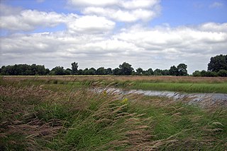
WA fen is one of the main types of wetlands, the others being grassy marshes, forested swamps, and peaty bogs. Along with bogs, fens are a kind of mire. Fens are minerotrophic peatlands, usually fed by mineral-rich surface water or groundwater. They are characterized by their distinct water chemistry, which is pH neutral or alkaline, with relatively high dissolved mineral levels but few other plant nutrients. Continuous input of groundwater into fens maintains a stable water table throughout the course of a year. The stable water table helps maintain multiple defining characteristics of fens, namely the neutral pH, high base saturation, and low nutrient availability. They are usually dominated by grasses and sedges, and typically have brown mosses. Fens frequently have a high diversity of other plant species including carnivorous plants such as Pinguicula. They may also occur along large lakes and rivers where seasonal changes in water level maintain wet soils with few woody plants. The distribution of individual species of fen plants is often closely connected to water regimes and nutrient concentrations.
 W
WFreshwater fish are those that spend some or all of their lives in fresh water, such as rivers and lakes, with a salinity of less than 1.05%. These environments differ from marine conditions in many ways, the most obvious being the difference in levels of salinity. To survive fresh water, the fish need a range of physiological adaptations.
 W
WA hydrosere is a plant succession which occurs in an area of fresh water such as in oxbow lakes and kettle lakes. In time, an area of open freshwater will naturally dry out, ultimately becoming woodland. During this change, a range of different landtypes such as swamp and marsh will succeed each other.
WThe hypolimnion or under lake is the dense, bottom layer of water in a thermally-stratified lake. The word hypolimnion is derived from the Greek "limnos" meaning "lake". It is the layer that lies below the thermocline.
 W
WHypoxia refers to low oxygen conditions. Normally, 20.9% of the gas in the atmosphere is oxygen. The partial pressure of oxygen in the atmosphere is 20.9% of the total barometric pressure. In water, oxygen levels are much lower, approximately 7 ppm 0.0007% in good quality water, and fluctuate locally depending on the presence of photosynthetic organisms and relative distance to the surface.
 W
WIce is water frozen into a solid state. Depending on the presence of impurities such as particles of soil or bubbles of air, it can appear transparent or a more or less opaque bluish-white color.
 W
WLake metabolism represents a lake's balance between carbon fixation and biological carbon oxidation. Whole-lake metabolism includes the carbon fixation and oxidation from all organism within the lake, from bacteria to fishes, and is typically estimated by measuring changes in dissolved oxygen or carbon dioxide throughout the day.
WLake stratification is the tendency of lakes to form separate and distinct thermal layers during warm weather. Typically stratified lakes show three distinct layers, the Epilimnion comprising the top warm layer, the thermocline : the middle layer, which may change depth throughout the day, and the colder Hypolimnion extending to the floor of the lake.
 W
WThe limnetic zone is the open and well-lit area of a freestanding body of freshwater, such as a lake or pond. Not included in this area is the littoral zone, which is the shallow, near-shore area of the water body. Together, these two zones comprise the photic zone.
 W
WA limnological tower is a structure constructed in a body of water to facilitate the study of aquatic ecosystems (limnology). They play an important role in drinking water infrastructure by allowing the prediction of algal blooms which can block filters and affect the taste of the water.
 W
WThe littoral zone or nearshore is the part of a sea, lake, or river that is close to the shore. In coastal environments, the littoral zone extends from the high water mark, which is rarely inundated, to shoreline areas that are permanently submerged. The littoral zone always includes this intertidal zone, and the terms are often used interchangeably. However, the meaning of littoral zone can extend well beyond the intertidal zone.
 W
WMallín is a type of meadow and wetland found in southern Chile and Argentina. Mallines are distinguished from other wetlands in that the groundwater level reaches the surface at them, yet the mallín is still an area of net infiltration. Soils in mallines are rich in organic matter. In Argentina mallins have been important grazing lands for cattle, sheep and horses. In eastern Patagonia the base of basaltic plateaus are associated with mallines.
 W
WThe Max Planck Institute for Evolutionary Biology is a German institute for evolutionary biology. It is located in Plön, Schleswig-Holstein, Germany.
 W
WA meander is one of a series of regular sinuous curves, bends, loops, turns, or windings in the channel of a river, stream, or other watercourse. It is produced by a stream or river swinging from side to side as it flows across its floodplain or shifts its channel within a valley. A meander is produced by a stream or river as it erodes the sediments comprising an outer, concave bank and deposits this and other sediment downstream on an inner, convex bank which is typically a point bar. The result of sediments being eroded from the outside concave bank and their deposition on an inside convex bank is the formation of a sinuous course as a channel migrates back and forth across the down-valley axis of a floodplain. The zone within which a meandering stream shifts its channel across either its floodplain or valley floor from time to time is known as a meander belt. It typically ranges from 15 to 18 times the width of the channel. Over time, meanders migrate downstream, sometimes in such a short time as to create civil engineering problems for local municipalities attempting to maintain stable roads and bridges.
 W
WPaleolimnology is a scientific subdiscipline closely related to both limnology and paleoecology. Palaeolimnological studies are concerned with reconstructing the paleoenvironments of inland waters – and especially changes associated with such events as climatic change, human impacts, and internal ontogenic processes.
 W
WPaludification is the most common process by which peatlands in the boreal zone are formed.
 W
WThe pCO2, PCO2, or is the partial pressure of carbon dioxide (CO2), often used in reference to blood but also used in oceanography to describe the partial pressure of CO2 in the ocean and in life support systems engineering and underwater diving to describe the partial pressure in a breathing gas. Usually, the arterial blood is the relevant context; the symbol for in arterial blood is . Measurement of in the systemic circulation indicates the effectiveness of ventilation at the lungs' alveoli, given the diffusing capacity of the gas. It is a good indicator of respiratory function and the closely related factor of acid–base homeostasis, reflecting the amount of acid in the blood (without lactic acid).
 W
WA planktivore is an aquatic organism that feeds on planktonic food, including zooplankton and phytoplankton.
WA point bar is a depositional feature made of alluvium that accumulates on the inside bend of streams and rivers below the slip-off slope. Point bars are found in abundance in mature or meandering streams. They are crescent-shaped and located on the inside of a stream bend, being very similar to, though often smaller than, towheads, or river islands.
 W
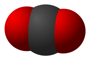
WWater is a polar inorganic compound that is at room temperature a tasteless and odorless liquid, which is nearly colorless apart from an inherent hint of blue. It is by far the most studied chemical compound and is described as the "universal solvent" and the "solvent of life." It is the most abundant substance on Earth and the only common substance to exist as a solid, liquid, and gas on Earth's surface. It is also the third most abundant molecule in the universe.
 W
WA puddle is a small accumulation of liquid, usually water, on a surface. It can form either by pooling in a depression on the surface, or by surface tension upon a flat surface.
 W
WRapids are sections of a river where the river bed has a relatively steep gradient, causing an increase in water velocity and turbulence.
 W
WIn stream restoration, river engineering or coastal engineering, revetments are sloping structures placed on banks or cliffs in such a way as to absorb the energy of incoming water. In military engineering they are structures, again sloped, formed to secure an area from artillery, bombing, or stored explosives. River or coastal revetments are usually built to preserve the existing uses of the shoreline and to protect the slope, as defense against erosion.
 W
WIn a flowing stream, a riffle-pool sequence develops as a stream's hydrological flow structure alternates from areas of relatively shallow to deeper water. This sequence is present only in streams carrying gravel or coarser sediments. Riffles are formed in shallow areas by coarser materials, such as gravel deposits, over which water flows. Pools are deeper, calmer areas whose bed load is made up of finer material such as silt. Streams with only sand or silt laden beds do not develop the feature. The sequence within a stream bed commonly occurs at intervals of from 5 to 7 stream widths. Meandering streams with relatively coarse bed load tend to develop a riffle-pool sequence with pools in the outsides of the bends and riffles in the crossovers between one meander to the next on the opposite margin of the stream. The pools are areas of active erosion and the material eroded tends to be deposited in the riffle areas between them.
 W
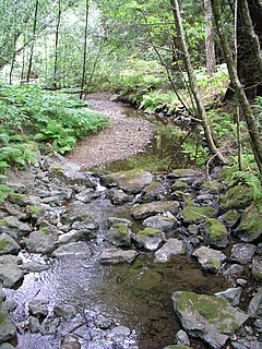
WRiver ecosystems are flowing waters that drain the landscape, and include the biotic (living) interactions amongst plants, animals and micro-organisms, as well as abiotic (nonliving) physical and chemical interactions of its many parts. River ecosystems are part of larger watershed networks or catchments, where smaller headwater streams drain into mid-size streams, which progressively drain into larger river networks.
 W
WSchlatt or Flatt is the Lower Saxon name for a heathland pond, an undrained body of water usually shallow, that is fed by surface water and is largely unaffected by ground water. The water is impounded by a water-retentive layer. Most Schlatts can dry out from time to time.
 W
WSediment traps are instruments used in oceanography and limnology to measure the quantity of sinking particulate organic material in aquatic systems, usually oceans, lakes, or reservoirs. This flux of material is the product of biological and ecological processes typically within the surface euphotic zone, and is of interest to scientists studying the role of the biological pump in the carbon cycle.
 W
WA seiche is a standing wave in an enclosed or partially enclosed body of water. Seiches and seiche-related phenomena have been observed on lakes, reservoirs, swimming pools, bays, harbours and seas. The key requirement for formation of a seiche is that the body of water be at least partially bounded, allowing the formation of the standing wave.
 W
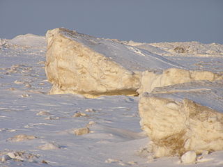
WShelf ice is ice that forms when a portion of a lake surface freezes. It is often then washed upon the shore. The phenomenon is common within the Great Lakes.
 W
WA slip-off slope is a depositional landform that occurs on the inside convex bank of a meandering river. The term can refer to two different features: one in a freely meandering river with a floodplain and the other in an entrenched river.
 W
WIn forest ecology, a snag refers to a standing, dead or dying tree, often missing a top or most of the smaller branches. In freshwater ecology it refers to trees, branches, and other pieces of naturally occurring wood found sunken in rivers and streams; it is also known as coarse woody debris. When used in manufacturing, especially in Scandinavia, they are often called "dead wood" and in Finland "kelo wood".
 W
WA stream bed or streambed is the channel bottom of a stream or river, the physical confine of the normal water flow. The lateral confines or channel margins are known as the stream banks or river banks, during all but flood stage. Under certain conditions a river can branch from one stream bed to multiple stream beds. A flood occurs when a stream overflows its banks and flows onto its flood plain. As a general rule, the bed is the part of the channel up to the normal water line, and the banks are that part above the normal water line. However, because water flow varies, this differentiation is subject to local interpretation. Usually, the bed is kept clear of terrestrial vegetation, whereas the banks are subjected to water flow only during unusual or perhaps infrequent high water stages and therefore might support vegetation some or much of the time.
 W
WA thermocline is a thin but distinct layer in a large body of fluid in which temperature changes more drastically with depth than it does in the layers above or below. In the ocean, the thermocline divides the upper mixed layer from the calm deep water below.
 W
WThe Trophic State Index (TSI) is a classification system designed to rate water bodies based on the amount of biological productivity they sustain. Although the term "trophic index" is commonly applied to lakes, any surface water body may be indexed.
 W
WThe water cycle, also known as the hydrologic cycle or the hydrological cycle, describes the continuous movement of water on, above and below the surface of the Earth. The mass of water on Earth remains fairly constant over time but the partitioning of the water into the major reservoirs of ice, fresh water, saline water and atmospheric water is variable depending on a wide range of climatic variables. The water moves from one reservoir to another, such as from river to ocean, or from the ocean to the atmosphere, by the physical processes of evaporation, condensation, precipitation, infiltration, surface runoff, and subsurface flow. In doing so, the water goes through different forms: liquid, solid (ice) and vapor.