 W
WBatiki is an island of Fiji belonging to the Lomaiviti Archipelago. The island is of volcanic origin, with a land area of about 12 square kilometers. Its latitude is 17° 47' S; its longitude is 179° 9' W.
 W
WBeqa is an island in Fiji, an outlier to the main island of Viti Levu, 10 kilometres to the south. The island has a land area of 36 square kilometres and reaches a maximum altitude of 462 metres. Beqa has 9 villages broken into 2 Tikinas or Districts: Sawau and Raviravi.
WCicia is a Fijian island of the Lau Group. One of the Northern Lau Islands, Cicia is volcanic and is composed of raised coral. Its area is 34 square kilometres (13 sq mi).
 W
WDenarau Island is a small private resort development on the western side of Viti Levu in the Republic of Fiji. The 2.55 km2 resort is accessed via a short causeway over a creek and is located 5 km north west of the town Nadi and 10 km west of Nadi International Airport.
 W
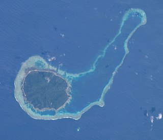
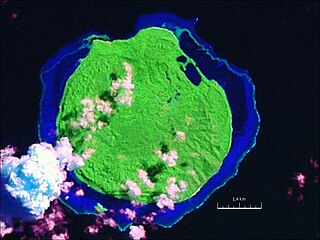
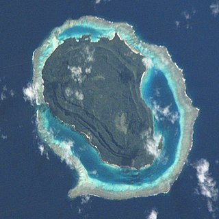
WDravuni is a volcanic island in the Kadavu Group of islands in Fiji. Covering an area of 0.8 km2 (0.3 sq mi), it is located at 18.78° South and 178.53° East, and reaches a maximum altitude of 40 metres (131 ft).
 W
WFulaga is a crescent-shaped reef-limestone island in Fiji's Southern Lau Group.
 W
WGau is an island belonging to Fiji's Lomaiviti archipelago. Located at 18.00° S and 179.30 °E, it covers an area of 136.1 square kilometres, with a total shoreline that measures 66.3 kilometres long, making it the fifth largest island in the Fijian archipelago. Its maximum altitude is 738 metres (2,421 ft).
WKabara is an island of Fiji, a member of the Lau archipelago. With a land area of 31 km2 (12 sq mi), its population of some 700 lives in four villages.
 W
WKadavu, with an area of 411 square kilometres (159 sq mi), is the fourth largest island in Fiji, and the largest island in the Kadavu Group, a volcanic archipelago consisting of Kadavu, Ono, Galoa and a number of smaller islands in the Great Astrolabe Reef. Its main administrative centre is Vunisea, which has an airport, a high school, a hospital, and a government station, on the Namalata Isthmus where the island is almost cut in two. Suva, Fiji's capital, lies 88 kilometres to the north of Kadavu. The population of the island province was 10,167 at the most recent census in 2007.
 W
WKanacea (Kanathea) is a volcanic island with seven peaks in Fiji's Lau archipelago. It is 15 km west of Vanua Balavu. Covering an area of 12.48 square kilometres, it has a maximum elevation of 259 meters.
WKioa is an island in Fiji, an outlier to Vanua Levu, one of Fiji's two main islands. Situated opposite Buca Bay, Kioa was purchased by settlers from Vaitupu atoll in Tuvalu, who came between 1947 and 1962.
 W
WKoro is a volcanic island of Fiji that forms part of the Lomaiviti Archipelago. The Koro Sea is named after this volcanic island, which has a chain of basaltic cinder cones extending from north to south along its crest. With a land area of 105.3 square kilometers, it is the seventh largest island of Fiji. Its latitude is 17.18°; its longitude is 179.24°. Its population in 1960 was around 2,500. As of 2007 around 4,500 Fijians lived on the island, in 14 villages,today a lot of families of European countries are building houses in this island. A roll-on, roll-off ferry services Koro twice weekly from Suva, and also connects Koro to Vanua Levu to the North. Northern Air provides one scheduled flight per week to Koro, usually on Saturday from Suva.
 W
WKuata is an island of the Yasawa Group in Fiji's Ba Province. Tourism is of growing importance to the island's economy. The small resort is very pleasant and friendly. It offers different types of accommodation from backpackers to en-suite, the food is quite good and the walk to the top of the island with views to Waya Island to the north are spectacular. Swimming in the lagoon is excellent. It is possible to snorkel with small sharks, to dive or learn diving. Several science and conservation projects are happening on the island.
 W
WLakeba is an island in Fiji’s Southern Lau Archipelago; the provincial capital of Lau is located here. The island is the tenth largest in Fiji, with a land area of nearly 60 square kilometers. It is fertile and well watered, and encircled by a 29-kilometer road. Its closest neighbors are Aiwa and Nayau. Separated by deep sea from the latter but only by shallow waters from the former, when sea levels were lower during glacial episodes Lakeba and Aiwa formed one large island.
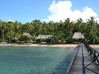
WLaucala is one of a triplet of small islands that lie to the east of Thurston Point on the island of Taveuni in Fiji. The privately owned islands are the site of the Laucala Resort.
 W
WLeleuvia is a coral cay in Fiji's Lomaiviti archipelago. The 68,000 square metres (731,946 sq ft) islet is the site of the Leleuvia Island Resort, previously operated by the Chinese-Fijian businessman Emosi Yee Shaw. Only recently in early 2006 has the Island been leased by a Company called Saluwaki Limited with the intention to refurbish the island resort. Leleuvia Island is popular among beachcombers and kite surfers. There is snorkelling directly off the beach.
 W
WMago Island is a volcanic island that lies in the northwest sector of Fiji's northern Lau Group of islands. One of the largest private islands in the southwestern Pacific Ocean, the pristine island consists of 22 square kilometres (8.5 sq mi) of land. The island is privately owned by actor/director Mel Gibson.
WMalolo is an inhabited volcanic island in the Pacific Ocean, near Fiji. Malolo was used as a tribe name in Survivor: Ghost Island. Malolo Island is the largest of the Mamanuca Islands and is home to two villages.
 W
WMalolo Lailai, also known as Plantation Island, is the second largest and most developed of the Mamanuca Islands, lying 20 kilometres west of Nadi on Fiji's main island Viti Levu. Malolo Lailai is the centre of tourism in the Mamanuca Islands, and consists of four resorts, a number of residential houses, a marina and a golf course. The island can be reached in 50 minutes from Port Denarau by the Malolo Cat, a catamaran, or by Malolo Lailai Airport, a 10-minute flight from Nadi International Airport. Separated by a small isthmus which can be walked at low tide, the larger island of Malolo Levu lies north-west of Malolo Lailai.
WMatuku is a volcanic island in the Moala subgroup of Fiji's Lau archipelago. Located at 19.18° South and 179.75° East, Matuku covers an area of 57 square kilometers. It has a maximum elevation of 385 meters. Matuku is part of a group of islands known as Yasayasa Moala.
WMoala is a volcanic island in the Moala subgroup of Fiji's Lau archipelago. It has an area of 62.5 square kilometers (24.1 sq mi), making it the ninth largest island of Fiji. The highest point on the island of Moala, at a maximum elevation of 468 meters (1,535 ft), is called Delaimoala which has rich vegetation and consists of dark thick forest. The population of around 3000 live in eight villages. The chiefly village of these is Naroi, whose population is over 500. Economic activities include coconut farming, cocoa production, fishing and yaqona (kava) production.
 W
WNacula is a hilly and volcanic island of the Yasawa Group in Fiji's Ba Province. It is the third-largest and is the second-farthest north in the group of islands.
WNaitaba Island is an island of the northern Lau Islands of Fiji. It is a triangular shaped island approximately 2.4 km (1.5 mi) in diameter. The island is volcanic with coral and rises to 186 metres (610 ft) on a flat-topped hill toward the southern end of the island. The island is forested and coconuts were grown commercially for copra. There is a barrier reef completely surrounding the island.
WNananu-i-Cake [nɑː.nɑːˈnuː iː ðɑːˈkeː] is an island in Fiji less than one kilometer off the coast of the main island of Viti Levu, near the Rakiraki-district in Ra Province.
 W
WNananu-I-Ra is an island in Fiji about 3 kilometers off the north coast of the main island of Viti Levu, near the town of Rakiraki in Ra Province. The island is 3.5 square kilometers and has a maximum elevation of 180 meters. The name "Nananu-I-Ra" means "Daydream of the West" in Fijian. Fijian mythology holds that Nananu-I-Ra is the point of departure for disembodied spirits leaving this world for the afterlife.
 W
WNanuya Lailai is an island of the Yasawa Group in Fiji. It is located north of Nanuya Levu, which served as a location for the film The Blue Lagoon, separated by a narrow channel.
 W
WNaviti is a volcanic island in the Yasawa Group, in the Western Division of Fiji. Located at 17.13° South and 177.25° East, Naviti covers an area of 34 square kilometres (13 sq mi), with a maximum elevation of 388 metres (1,273 ft).
 W
WNayau is an island of Fiji, a member of the Lau archipelago. Nearby cities: Suva; Nuku'Alofa;
 W
WOno-i-Lau is a group of islands within a barrier reef system in the Fijian archipelago of Lau Islands. There are four central volcanic islands: Onolevu, Doi Lovoni and Ndavura, the uppermost parts of the volcanic edifice rising from the Lau Ridge slightly more than 1,000 metres below sea level and on which the reef and other islands are built. There are also three clusters of coral limestone islets, Yanuya and Mana on the barrier reef and Niuta. A sand cay, Udui, is not counted as one of the six “islands”.
WOvalau is the sixth largest island in Fiji. It is located in Lomaiviti Archipelago. Situated at 17.70° South and 178.8° East,, the island is about 13 kilometers long and 10 kilometers wide. It covers a total area of 106.4 square kilometers and has a population of around 9,100, approximately half the Lomaiviti population. Levuka, Fiji's former capital, is the largest of 24 towns and villages on the island.
WQelelevu is a coral islet in Fiji, a member of the Ringgold Isles archipelago, which forms an outlier to the northern island of Vanua Levu. Apart from two nearby coral islets, Tai Ni Beka and Tauraria due west on the same atoll rim, it is 30 kilometres (19 mi) from the nearest island, which is Vetauua, to the West. Qelelevu covers an area of 1.5 square kilometers. Its maximum elevation is 12 metres (39 ft).
WRabi is a volcanic island in northern Fiji. It is an outlier to Taveuni, in the Vanua Levu Group. It covers an area of 66.3 square kilometers, reaching a maximum altitude of 463 meters and has a shoreline of 46.2 kilometers. With a population of around 5,000, Rabi is home to the Banabans who are the indigenous landowners of Ocean Island; the indigenous Fijian community that formerly lived on Rabi was moved to Taveuni after the island was purchased by the British government. The original inhabitants still maintain their links to the island, and still use the Rabi name in national competitions.
 W
WRobinson Crusoe Island is a tourism operation located on the island of Likuri, Fiji. Located off the southwest coast of the main island of Viti Levu, Fiji, and has a history dating back 3,500 years. The island is located near to Bourewa, an area that is believed is to be the first site for human settlement in Fiji. A pottery site found on the island has been dated back to 1500 BC. Prior to resort development, Likuri Island was reserved as a location for significant ceremonies and Chiefly gatherings. The traditional owner of Likuri Island is the High Chief, Ka Levu Tui Nadroga and the chiefly family.
 W
WRotuma is a Fijian dependency, consisting of Rotuma Island and nearby islets. The island group is home to a large and unique indigenous ethnic group which constitutes a recognisable minority within the population of Fiji, known as "Rotumans". Its population at the 2017 census was 1,594, although many more Rotumans live on mainland Fijian islands, totaling 10,000.
 W
WSawana is a village on the Fijian island of Vanua Balavu, in the Lau archipelago and is part of the Tikina of Lomaloma.
 W
WTavarua is an island resort in Fiji. It has an area of 29 acres (120,000 m2). It is close to the main Fijian island, Viti Levu, and is surrounded by a coral reef.
 W
WTaveuni is the third-largest island in Fiji, after Viti Levu and Vanua Levu, with a total land area of 434 square kilometres. The cigar-shaped island, a massive shield volcano which rises from the floor of the Pacific Ocean, is situated 6.5 kilometres to the east of Vanua Levu, across the Somosomo Strait. It belongs to the Vanua Levu Group of islands and is part of Fiji's Cakaudrove Province within the Northern Division.
 W
WTivua Island is an island of the Mamanuca Islands, Fiji.
 W
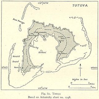
WTotoya is a volcanic island in the Moala subgroup of Fiji's Lau archipelago. It occupies an area of 28 km², making it the smallest of the Yasayasa Moala Group. Its maximum elevation is 366 metres above sea level. The main economic activity is coconut farming.
 W
WTuvana-i-Colo is an uninhabited atoll in the southeastern part of the island state of Fiji in the Pacific Ocean. It is the second most southern atoll of the Lau archipelago and represents Fiji's third most southern landmass. It is located about 25 km south of Ono-i-Lau, the southernmost inhabited Fijian atoll, and 8 kilometres east-northeast of the neighboring atoll Tuvana-i-Ra. It is completely surrounded by a fringing reef.
WTuvana-i-Ra is an uninhabited atoll in the southeastern part of the island state of Fiji in the Pacific Ocean. It is the southernmost atoll of the Lau archipelago and represents Fiji's second-southernmost landmass; only the remote and uninhabited atoll Ceva-i-Ra lies slightly further south.
 W
WTuvuca is a small island off Vanua Balavu in Fiji's Lau archipelago, it is a densely wooded and inhabited island and rises 800 feet above sea level at the highest point. There is only one village on the island. Tuvuca has untapped deposits of phosphate.
WVanua Balavu is the third largest island in Fiji's Lau archipelago, and the main island of the Northern Lau Group.
WVanua Levu, formerly known as Sandalwood Island, is the second largest island of Fiji. Located 64 kilometres to the north of the larger Viti Levu, the island has an area of 5,587.1 square kilometres (2,157.2 sq mi) and a population of 135,961 as of 2007.
 W
WVatoa is an outlier of Fiji's Lau Group.
WViti Levu is the largest island in the Republic of Fiji, the site of the nation's capital, Suva, and home to a large majority of Fiji's population.
 W
WWaya is an island in the southern part of the Yasawa Islands of Fiji. The island is part of Ba Province in the country's Western Division. Waya lies about 40 kilometres (25 mi) from Lautoka.
 W
WYasawa, also called Assawa and Ysava, is the northernmost large island of the Yasawa Group, an archipelago in Fiji's Western Division. Located at 17.00° South and 177.23° East, it covers an area of 32 square kilometres. It has a maximum altitude of 244 metres above sea level. The population was 1,120 in 1983.