 W
WThe Salinas Valley is one of the major valleys and most productive agricultural regions in California. It is located west of the San Joaquin Valley and south of San Francisco Bay and the Santa Clara Valley, or Silicon Valley.
 W
WArea code 831 is a telephone area code in the North American Numbering Plan (NANP) for a small region of the U.S. state of California. The numbering plan area (NPA) comprises Monterey County, San Benito County, and Santa Cruz County. The area code was created on July 11, 1998 in a split from area code 408.
 W
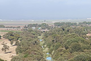
WThe Arroyo Seco is a major tributary of the Salinas River in central California. About 40 miles (64 km) long, it drains a rugged area of the Coast Ranges east of Big Sur before flowing through the agricultural Salinas Valley.
 W
WBradley is a census-designated place in Monterey County, California, United States. Bradley is located on the Salinas River 12 miles (19 km) south-southeast of San Ardo, at an elevation of 548 feet. The population was 93 at the 2010 census, down from 120 at the 2000 census.
 W
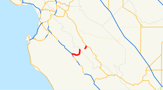
WState Route 146 is a state highway in the U.S. state of California in Monterey and San Benito Counties. The route serves as an entryway to Pinnacles National Park, located in the Gabilan Mountains, from both U.S. Route 101 in the Salinas Valley on the west and State Route 25 near Paicines on the east. The route is broken into two sections and cannot be used to completely pass through Pinnacles National Park.
 W
WCalifornia's 20th congressional district is a congressional district in the U.S. state of California.
 W
WCamphora is an unincorporated community in Monterey County, California. It is located on U.S. Route 101 and the Southern Pacific Railroad line, 3 miles (4.8 km) northwest of Soledad, at an elevation of 171 feet.
 W
WCastroville is a census-designated place (CDP) in Monterey County, California, United States. At the time of the 2010 census the population was 6,481.
 W
WThe Chalon people are one of eight divisions of the Ohlone (Costanoan) people of Native Americans who lived in Northern California. Chalon is also the name of their spoken language, listed as one of the Ohlone languages of the Utian family. Recent work suggests that Chalon may be transitional between the northern and southern groups of Ohlone languages.
 W
WChualar is a census-designated place (CDP) in the Salinas Valley of Monterey County, California. Chualar is located 10 miles (16 km) southeast of Salinas, at an elevation of 115 feet. The population was 1,190 at the 2010 census, down from 1,444 at the 2000 census.
WCoburn is an unincorporated community in Monterey County, California. It is located on the Southern Pacific Railroad and County Route G15 5.5 miles (8.9 km) east-southeast of Greenfield, at an elevation of 282 feet.
WCooper is an unincorporated community in Monterey County, California, United States. It is located on the Southern Pacific Railroad and California State Route 183 4.5 miles (7.2 km) northwest of Salinas and southeast of Castroville. The elevation is 23 feet.
 W
WCorral de Tierra is an unincorporated community in Monterey County, California. It is located in the Corral de Tierra Valley, on the former land grant of Corral de Tierra, at an elevation of 404 feet.
WDean is an unincorporated community in Monterey County, California. It is located on the Southern Pacific Railroad and U.S. Route 101 1.25 miles (2 km) northwest of Gonzales, at an elevation of 125 feet.
WDocas is a former settlement in Monterey County, California. It was located on the Southern Pacific Railroad 5 miles (8 km) north-northwest of San Ardo, at an elevation of 404 feet. It still appeared on USGS maps as of 1943.
WElsa is an unincorporated community in Monterey County, California. It is located on the Southern Pacific Railroad and County Route G15 2.5 miles (4 km) north-northwest of King City, at an elevation of 302 feet.
WFort Romie is an unincorporated community in Monterey County, California. It is located 2 miles (3.2 km) south-southwest of Soledad off County Route G17, at an elevation of 187 feet.
WGabilan was a former settlement in Monterey County, California. It was located on the Southern Pacific Railroad 4 miles (6.4 km) northwest of Gonzales, at an elevation of 112 feet, and was situated in the foothills of the Gabilan Range. In Spanish, gavilan means "sparrow hawk". Hawks, especially the red-tailed hawk, are common in the area.
 W
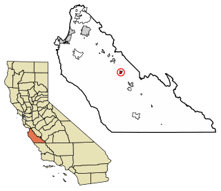
WGonzales is a city in Monterey County, California, United States. Gonzales is located 16 miles (26 km) southeast of Salinas, at an elevation of 135 feet. The population was 8,187 at the 2010 census, up from 7,525 at the 2000 census. Gonzales is a member of the Association of Monterey Bay Area Governments.
 W
WGreenfield is a city in Monterey County, California, United States in the Salinas Valley, 33 miles (53 km) southeast of Salinas, at an elevation of 289 feet. The city was the fastest growing in the county during the 2000s, the population was 12,583 in 2000, increasing to 16,330 in the 2010 census. Its most well-known public event is the annual Harvest Festival. Greenfield is a member of the Association of Monterey Bay Area Governments.
 W
WKing City is a city in Monterey County, California, United States. King City is located on the Salinas River 51 miles (82 km) southeast of Salinas, at an elevation of 335 feet. It lies along U.S. Route 101 in the Salinas Valley of the Central Coast. King City is a member of the Association of Monterey Bay Area Governments. The population was 12,874 at the 2010 census. It is a small town which has experienced slow economic growth over the past 50 years.
 W
WLockwood is a census-designated place in Monterey County, California. It is 6 miles (9.7 km) east-southeast of Jolon, 1.8 miles (2.9 km) north of the mouth of Tule Canyon, 3.0 miles (4.8 km) north of the San Antonio River, and 9.3 miles (15.0 km) north of Bryson, at an elevation of 971 feet (296 m).
WMetz is an unincorporated community in the Salinas Valley, in Monterey County, California. It is located on the Southern Pacific Railroad and County Route G15, 3 miles (4.8 km) northeast of Greenfield, at an elevation of 236 feet.
 W
WMission Nuestra Señora de la Soledad, known colloquially as the Soledad Mission or "Our Lady of Solitude" or Mission Soledad, is a Spanish mission located near the present-day town of Soledad, California. The mission was founded by the Franciscan order on October 9, 1791 to convert the Native Americans living in the area to Catholicism. It was the thirteenth of California's Spanish missions, and is named for Mary, Our Lady of Solitude. The town of Soledad is named for the mission.
 W
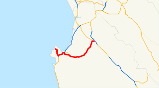
WState Route 68 is a state highway in the U.S. state of California, located entirely in Monterey County. It runs from Asilomar State Beach in Pacific Grove to U.S. Route 101 in Salinas. The approximately 20-mile (32 km) long highway serves as a major route between the Monterey Peninsula and Salinas.
 W
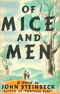
WOf Mice and Men is a novella written by John Steinbeck. Published in 1937, it narrates the experiences of George Milton and Lennie Small, two displaced migrant ranch workers, who move from place to place in California in search of new job opportunities during the Great Depression in the United States.
 W
WOld Hilltown, formerly Hill Town, is an unincorporated community in Monterey County, California. It is located on the north side of the Salinas River 3 miles (4.8 km) south-southwest of Salinas on California State Route 68, at an elevation of 46 feet, approximately two miles from Spreckels, California The name is from James Bryant Hill, one of the first settler in the area. The first European land exploration of Alta California, the Spanish Portolá expedition, camped on the Salinas River in this vicinity on September 30, 1769, having followed the river from the south for several days. From this camp, the scouts went out to survey the route ahead and saw Monterey Bay for the first time. Unsure whether the point they could see at the southern end of the bay was the "Point of Pines" described by Sebastian Vizcaino in 1602, Portola decided that the party should investigate.
WRancho San Lucas was a 8,875-acre (35.92 km2) Mexican land grant in the Salinas Valley, in present-day Monterey County, California given in 1842 by Governor Juan B. Alvarado to Rafael Estrada. The grant extended along the west bank of the Salinas River south of present-day San Lucas.
 W
WThe Rumsen language is one of eight Ohlone languages, historically spoken by the Rumsen people of Northern California. The Rumsen language was spoken from the Pajaro River to Point Sur, and on the lower courses of the Pajaro, as well as on the Salinas and Carmel Rivers, and the region of the present-day cities of Salinas, Monterey and Carmel.
 W
WThe Rumsen are one of eight groups of the Ohlone, an indigenous people of California.
 W
WThe Salinan are a Native American tribe whose ancestral territory is in the southern Salinas Valley and the Santa Lucia Range in the Central Coast of California. Today, the Salinan governments are now working toward federal tribal recognition from the Bureau of Indian Affairs.
 W
WThe Salinas River is the longest river of the Central Coast region of California, running 175 miles (282 km) and draining 4,160 square miles. It flows north-northwest and drains the Salinas Valley that slices through the central California Coast Ranges south of Monterey Bay. The river begins in southern San Luis Obispo County, originating in the Los Machos Hills of the Los Padres National Forest. From there, the river flows north into Monterey County, eventually making its way to connect with the Monterey Bay, part of the Pacific Ocean, approximately 5 miles south of Moss Landing. The river is a wildlife corridor, and provides the principal source of water from its reservoirs and tributaries for the farms and vineyards of the valley.
 W
WSalinas Valley State Prison (SVSP) is a 300-acre (120 ha) California state prison located 5 miles (8 km) north of Soledad, in Monterey County, California, adjacent to the Correctional Training Facility.
 W
WSalinas is a city in Monterey County, California, United States. With a population of 155,564, Salinas is the most populous city in Monterey County, as well as its county seat. Salinas is an urban area located just outside the southern portion of the Greater Bay Area and 10 miles (16 km) southeast of the mouth of the Salinas River. The city is located at the mouth of the Salinas Valley, roughly eight miles from the Pacific Ocean, and it has a climate more influenced by the ocean than the interior.
 W
WThe San Ardo Oil Field is a large oil field in Monterey County, California, in the United States. It is in the Salinas Valley, about five miles (8 km) south of the small town of San Ardo, and about 20 miles (32 km) north of Paso Robles. With an estimated ultimate recovery of 532,496,000 barrels (84,660,100 m3) of oil, it is the eighth-largest producing oil field in California, and of the top 20 California oil fields in size, it is the most recent to be discovered (1947). As of the end of 2006, the principal operators of the field were Chevron Corp. and Aera Energy LLC.
 W
WSan Ardo is a census-designated place (CDP) in Monterey County, California, United States. San Ardo is located 18 miles (29 km) southeast of King City, at an elevation of 449 feet. The population was 517 at the 2010 census, up from 501 at the 2000 census.
WSan Benancio is an unincorporated community in Monterey County, California. It is located in the San Benancio Canyon.
 W
WSan Lucas is a census-designated place (CDP) in Monterey County, California, United States. San Lucas was founded in 1886 and named after the San Lucas Rancho, which was granted in 1842 and named in honor of Saint Luke. The post office was first established in 1892.
 W
WSierra de Salinas is a mountain range in the California Coast Ranges, located in central Monterey County, California. The range is a part of the Salinian Block and lies between the Santa Lucia Range to the west and the Salinas Valley, Salinas River, and Gabilan Range to the east.
WSoledad is a city in Monterey County, California, United States. Soledad is located 25 miles (40 km) southeast of Salinas, at an elevation of 190 feet. The population was 25,738 at the 2010 census.
WSpence is an unincorporated community in Monterey County, California.
WSpreckels Junction is an unincorporated community in Monterey County, California. It is located on the Southern Pacific Railroad southeast of Salinas, at an elevation of 62 feet. A branch rail line from Spreckels joins the main line at Spreckels Junction, whence the name.
 W
WSpreckels is a census-designated place (CDP) located in the Salinas Valley of Monterey County, California, United States. Spreckels is located 3 miles (4.8 km) south of Salinas, at an elevation of 62 feet. The population was 673 at the 2010 census, up from 485 at the 2000 census.
 W
WSpringtown is an unincorporated community in Monterey County, California, United States.
 W
WSycamore Flat is an unincorporated community in Monterey County, California. It is located on Arroyo Seco 9 miles (14 km) west-southwest of Greenfield, at an elevation of 617 feet.
WWunpost is an unincorporated area in Monterey County, California. It is located on the Southern Pacific Railroad 5.5 miles (8.9 km) northwest of Bradley, at an elevation of 495 feet.