 W
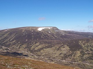
WA' Mharconaich is a Scottish mountain that is located 29 km WNW of Blair Atholl in the Highland council area. It is in a group of mountains that lie west of the A9 road near the summit of the Pass of Drumochter and are known accordingly as the Drumochter Hills. The hill is just within the Cairngorms National Park although it is not part of the Cairngorms mountains.
 W
WAm Bodach is a Scottish mountain which lies in the Mamores range, four kilometres north of Kinlochleven in the Highland council area.
 W
WAn Gearanach is a Scottish mountain situated in the Mamore Forest, five and a half kilometres north of Kinlochleven in the Lochaber region of the Highland council area.
 W
WAonach Beag is a mountain in the Highlands of Scotland. It is located about 3 km east of Ben Nevis on the north side of Glen Nevis, near the town of Fort William. Apart from Ben Nevis, Aonach Beag is the highest peak in the British Isles outwith the Cairngorm mountains of eastern Scotland.
 W
WAonach Beag is a 1,116-metre (3,661 ft) mountain in the Highlands of Scotland in the remote area between Loch Ericht and Loch Laggan located about 4 kilometres (2.5 mi) northwest of Ben Alder. Its prominence is 99 metres (325 ft) with its parent peak, Geal-Charn, about 1 kilometre (0.62 mi) to the east. In Gaelic, Aonach Beag means "little ridge" despite it being a Munro. It should not be confused with the better-known Munro near Ben Nevis, also called Aonach Beag, about 30 kilometres (19 mi) to the west.
 W
WThe Aonach Eagach is a rocky ridge lying to the north of Glen Coe in the Scottish Highlands, boasting two Munro summits. In length the full ridge continues for 10 km from the Pap of Glencoe at the west to the eastern end at the Devil's Staircase. The central section, some 2 km in length, is very rocky and the route along it requires scrambling ability. The slopes to each side are extremely dangerous, with steep grass and scree slopes hiding even steeper slopes which end in cliffs on both north and south sides of the ridge.
 W
WAonach Mòr is a mountain in the Highlands of Scotland. It is located about 2 miles north east of Ben Nevis on the south side of Glen Spean, near the town of Fort William. The Nevis Range ski area is located on the northern slopes of the peak; the use of this name has inspired some controversy, as it has been considered by some to represent a deliberate changing of an indigenous name.
 W
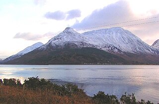
WBeinn a' Bheithir is a mountain lying to the south of Ballachulish, on the south side of Loch Leven in the Scottish Highlands. It boasts two Munro summits: the higher peak Sgorr Dhearg lies about 2 km (1.2 mi) east of Sgorr Dhonuill.
 W
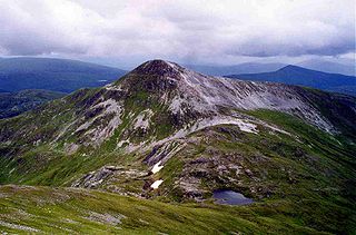
WBeinn a’ Chaorainn is a Scottish mountain situated on the northern side of Glen Spean in the Lochaber region of the Highland Council area. The mountain which is located 30 km east-northeast of Fort William is one of several of the same name in the Scottish Highlands and should not be confused with another well known Beinn a’ Chaorainn in the Cairngorms.
 W
WBeinn a' Chrùlaiste is a mountain to the north of Glen Coe, in the Highlands of Scotland. The Mountain is rectangular, and can be seen from the A82 road and the Old Military Road. Also, when passing the A82, it is possible to see the summit of Stob Dearg. Beinn a' Chrulaiste stands at 857 m (2811 ft), making it a Corbett.
 W
WBeinn a’ Chuallaich is a Scottish hill, four kilometres northeast of the village of Kinloch Rannoch in the Perth and Kinross council area. It is part of the high ground between Strath Tummel and Glen Errochty.
 W
WBeinn Udlamain is a Scottish mountain which stands just to the west of the summit of the Pass of Drumochter and east of Loch Ericht, some 30 km west-northwest of the village of Blair Atholl. The mountain’s summit stands on the border between the Highland and Perth and Kinross council areas.
 W
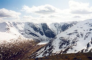
WBen Alder is the highest mountain in the remote area of the Scottish Highlands between Loch Ericht and Glen Spean. The vast summit plateau is home of one of Britain's highest bodies of standing water, Lochan a' Garbh Coire. It is the 25th highest Munro, and due to its remote location, one of the less frequently visited. Situated 19 km from Dalwhinnie and 15 km from Corrour railway station, it is commonly climbed in a two-day expedition, usually taking in its lower neighbour, Beinn Bheoil. There are two bothies near to the mountain: Culra Lodge to the northeast and Ben Alder Cottage to the south, both potentially providing shelter for walkers in the area. Ben Alder Cottage is reputed to be haunted by the ghost of a ghillie who hanged himself from the rafters.
 W
WBen Nevis is the highest mountain in the British Isles, situated in Inverness-shire in the Highlands of Scotland. The summit is 1,345 metres (4,413 ft) above sea level. Ben Nevis stands at the western end of the Grampian Mountains in the region of Lochaber, close to the town of Fort William. The summit is the highest land in any direction for 459 miles (739 km).
 W
WBidean nam Bian, lying to the south of Glen Coe, Highland, Scotland, is the highest point in the former county of Argyll. It is a complex mountain, with many ridges and subsidiary peaks, one of which, Stob Coire Sgreamhach, is classified as a separate Munro.
 W
WBinnein Beag is a Scottish mountain situated at the eastern end of the Mamores range seven kilometres north north-east of Kinlochleven. It is a relatively small, conical peak which is connected to its larger neighbour, Binnein Mòr, by a bealach at 750m. Despite being overshadowed by Binnein Mòr, it is listed as a Munro with a height of 943 m (3094 ft). It is commonly climbed from Kinlochleven in combination with Binnein Mòr. Its summit gives good views of Ben Alder to the east, the Grey Corries to the north, and the vast bulk of Binnein Mòr to the south-west.
 W
WBinnein Mòr is the highest peak in the Mamores, the range of mountains between Glen Nevis and Loch Leven in the Highlands of Scotland and lies five kilometres north north-east of Kinlochleven. The pyramidal summit of Binnein Mòr lies above the uninhabited upper section of Glen Nevis, north of the main Mamores ridge. To the south, a short narrow ridge links to the main ridge at an unnamed 1062 m subsidiary top listed in Munro's Tables as Binnein Mòr south top. Binnein Mòr's second subsidiary top, Sgòr Eilde Beag (956 m), lies about a kilometre to the southeast and forms the eastern end of the main Mamores ridge.
 W
WBuachaille Etive Beag, is a mountain located between Glen Coe and Glen Etive, on the edge of Rannoch Moor in the Scottish Highlands. Viewed from the south in Glen Etive it forms a twin with Buachaille Etive Mòr, from which it is separated by a bealach at a height of about 480 metres.
 W
WBuachaille Etive Mòr, generally known to climbers simply as The Buachaille, is a mountain at the head of Glen Etive in the Highlands of Scotland. Its pyramidal form, as seen from the A82 road when travelling towards Glen Coe, makes it one of the most recognisable mountains in Scotland, and one of the most depicted on postcards and calendars.
 W
WCàrn Dearg is the highest peak of the Monadh Liath mountains in the Highlands of Scotland. Its eastern flanks slope steeply down into Glen Ballach, while to the north, the large plateau of the Monadh Liath extends for many miles. The nearest settlements are Newtonmore and Kingussie in the Spey valley. The rocky slopes of Carn Dearg and A' Chailleach contrast with the remainder of the Monadh Liath, which are described by Cameron McNeish as "sprawling, undistinguished affairs .
 W
WCàrn Mòr Dearg is the ninth-highest mountain in Scotland. It is situated in the west of Scotland, close to the town of Fort William, in Lochaber, Highland. It lies just to the north-west of its much more famous neighbour, Ben Nevis, to which it is linked by the spectacular Càrn Mòr Dearg Arête.
 W
WChno Dearg is a Scottish mountain situated 25 km east of Fort William, Highland in the Lochaber area of the Highland council area.
 W
WCoire Gabhail is a high level glen in the Bidean nam Bian mountain massif to the south of Glen Coe, Highland, Scotland. Its narrow entrance 230 metres (750 ft) up the hillside conceals the width of the glen beyond, and it is commonly known as the Hidden Valley or Lost Valley of Glencoe. Access from a bridge crossing the River Coe is by a steep path up beside a narrow wooded ravine.
 W
WCreag Meagaidh is a mountain on the northern side of Glen Spean in the Highlands of Scotland. It is a complex mountain, taking the form of a flat summit plateau from which five ridges radiate, and is most famed for the cliffs surrounding the corrie of Coire Ardair on the north-eastern face. These crags are a renowned venue for winter and ice climbing, although being somewhat vegetated they are less suited to summer climbing.
 W
WGeal-Chàrn is a mountain in the Highlands of Scotland, 14 kilometres North East of Corrour railway station
WGlen Coe is a glen of volcanic origins, in the Highlands of Scotland. It lies in the north of the county of Argyll, close to the border with the historic province of Lochaber, within the modern council area of Highland. The scenic beauty of the glen has led to its inclusion in the Ben Nevis and Glen Coe National Scenic Area, one of 40 such areas in Scotland. A review of the national scenic areas by Scottish Natural Heritage in 2010 made reference to the "soaring, dramatic splendour of Glen Coe", and "the suddenness of the transition between high mountain pass and the lightly wooded strath" in the lower glen. It also described the journey through the glen on the main A82 road as "one of the classic Highland journeys". The main settlement is the village of Glencoe located at the foot of the glen. The glen is regarded as the home of Scottish mountaineering and is popular with hillwalkers and climbers.
 W
WThe Grey Corries are a range of mountains in the West Highlands of Scotland. The range includes several of Scotland's highest peaks including a number of Munros. The range is bounded to the north by the great extent of Leanachan Forest beyond which is Glen Spean and the Great Glen, to the east by the defile of Lairig Leacach and to the south by upper Glen Nevis and the headwaters of the Abhainn Rath. The ridge continues westwards at a high level to join Aonach Beag, Aonach Mor, Carn Mor Dearg and Ben Nevis.
 W
WLeum Uilleim is a mountain in Lochaber, Highland, Scotland which appeared in the film Trainspotting. It is situated about 3 km south-west of the remote Corrour railway station, but is considerably further from any road.
 W
WMeall a' Bhùiridh (IPA:[ˈmauɫ̪ˈaˈvuːɾʲɪʝ]) is a mountain on the edge of Rannoch Moor in the Highlands of Scotland. It lies near the top of Glen Coe and Glen Etive, overlooking the Kings House Hotel inn and the A82 road. The Glencoe Ski area is located on the northern slopes of the peak.
 W
WMullach nan Coirean is a Scottish mountain situated in the Mamores group of hills. It reaches a height of 939 metres (3081 feet) and is located eight kilometres north-west of Kinlochleven. It is the most westerly of the ten Munros in the Mamores and it is connected to the adjoining mountain of Stob Bàn by a bealach with a height of 846 metres; these two Munros are often climbed together from Glen Nevis. The mountain's name translates from the Gaelic as Summit of the Corries or Top of the Corries and this is quite fitting as Mullach nan Coirean has four corries on its slopes. Mullach can also mean a "roof". However it is unusual that the name does not include reference to the mountain's distinct red tinge cause by its red granite rock.
 W
WNa Gruagaichean is a Scottish mountain lying between Glen Nevis to the North and the village of Kinlochleven to the South in the Mamores mountain range in the Highlands, Scotland.
 W
WThe Pap of Glencoe is a mountain on the northern side of Glen Coe, in the Highlands of Scotland. It lies at the western end of the Aonach Eagach ridge, directly above the point where the River Coe enters Loch Leven.
 W
WSgùrr a' Mhàim is a Scottish mountain situated 5.5 kilometres (3.4 mi) north north-west of Kinlochleven in the Lochaber region of the Highland area.
 W
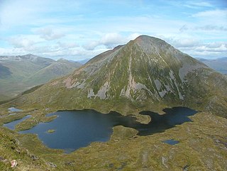
WSgùrr Eilde Mòr is a Scottish mountain situated in the Mamores range, 6 kilometres north-east of Kinlochleven. It is a steep, conical peak of scree and quartzite boulders, capped with a layer of schist. With a height of 1010 m (3314 ft) it is classed as a Munro, so is popular with hillwalkers. It is most commonly climbed from Kinlochleven by way of a stalker's path which leads to a col at Coire an Lochan, and then by either the south or the west ridge - both routes involving an ascent of steep, bouldery terrain.
 W
WSgùrr na h-Ulaidh is a mountain lying to the south of the village of Glencoe in the Scottish Highlands. The mountain cannot be seen from the main A82 road as it is hidden behind Aonach Dubh a'Ghlinne.
 W
WThe Sow of Atholl is a Scottish hill which is situated 27 kilometres west-northwest of the town of Blair Atholl in Perth and Kinross council area. It stands on the western side of the Pass of Drumochter in a group of hills which lie around Coire Dhomhain.
 W
WStob a' Choire Mheadhoin is a mountain in the Scottish Highlands, it is situated 19 km east of Fort William in the Lochaber area of the Highland council area.
 W
WStob Bàn is a mountain situated in the Lochaber region of Highland, Scotland, 16 kilometres east of Fort William. It reaches a height of 977 metres (3205 feet) and lies in a group of hills known as the Grey Corries which includes three other Munros and nine Munro "Tops" along an eight kilometre ridge. The mountain’s name translate as “White Peak”, while other sources give the translation as Light Coloured Peak with the hill being covered in light coloured schist scree, in contrast to the rest of the Grey Corries which are made up of grey quartzite scree. The mountain is a prominent conical shape, isolated from the rest of the group and distant from any main roads. It should not be confused with another Munro named Stob Bàn situated in the Mamores.
 W
WStob Bàn is a Scottish mountain situated at the western end of the Mamores ridge, five and a half kilometres north-west of Kinlochleven. With a height of 999 metres it qualifies as a Munro. Stob Bàn is a distinctive sight when viewed from lower Glen Nevis with its sharp peak and capping of white quartzite rocks which are often mistaken for snow; its Gaelic name translates as White Peak or Light Coloured Peak.
WStob Choire Claurigh is a Scottish mountain situated 16 km (10 mi) east of Fort William in the Lochaber district of the Highland council area. It is part of one of the best ridge walks on the Scottish mainland.
 W
WStob Coire a’ Chàirn is a Scottish mountain situated in the Mamores range, 3.5 kilometres north of Kinlochleven. The mountain reaches a height of 981 metres (3218 feet) and is regarded as one of the more modest peaks of the ten Munros in the Mamores, indeed for many years it was not named on OS maps. Despite this, it is situated at a strategically important point and could be said to be the most central of the group with three ridges radiating out to other Munros. The mountains name translates from Gaelic as “Peak of the Corrie of the Cairn”.
 W
WStob Coire an Laoigh is a Scottish mountain in The Grey Corries Range, 15 kilometres north east of Kinlochleven.
 W
WStob Coire Easain is a Scottish Munro mountain which reaches a height of 1115 metres (3658 feet), situated 18 kilometres east of Fort William. It stands on the western side of Loch Treig, along with its "twin", the Munro Stob a' Choire Mheadhoin. Collectively the pair are called "The Easains" or the "Stob Corries" and stand just one kilometre apart connected by a high col with an approximate height of 965 metres. The fine corrie of Coire Easain Beag lies in between the two mountains facing north west. Stob Coire Easain’s name translates from the Gaelic as “Peak of the Corrie of the Little Waterfall”. This mountain should not be confused with another Stob Coire Easain, a Munro “Top” on the Munro Stob Coire an Laoigh
 W
WStob Coire Sgreamhach is a mountain in Scotland, forming part of the Bidean nam Bian massif on the southern side of Glen Coe. It is often considered a subsidiary peak of Bidean, though since the 1997 revision of Munros Tables it has been classified as a separate Munro.
 W
WTom a' Chòinich is a 1,112-metre (3,648 ft) mountain in Glen Affric in the Scottish Highlands. It is a Munro and less than 1 kilometre to the west is the 1,032-metre (3,386 ft) Munro Top Tom a' Chòinich Beag. In Gaelic, Tom a' Chòinich means "mossy hillock". Its prominence is 149 metres (489 ft) with its parent peak, Càrn Eige, about 4 kilometres (2.5 mi) to the west. This mountain should not be confused with the 955-metre (3,133 ft) Munro Top also called Tom a' Chòinnich near Ben Wyvis but which is usually spelled slightly differently.
 W
WTower Ridge is one of several ridges protruding north east from the summit plateau of Ben Nevis, the highest mountain in the United Kingdom.