 W
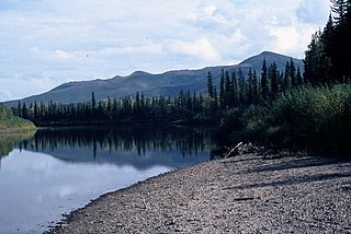
WThe Alatna River is a federally designated wild and scenic river partially contained within the boundaries of Gates of the Arctic National Park, Alaska. It is called one of the most beautiful rivers in the United States. The Alatna River stems from the central Brooks Range flowing through the Endicott Mountains, passing Circle Lake, the Arrigetch Peaks and Takahula Lake before entering the Helpmejack Hills. The last section of the river continues to flow in a SSE direction through the Alatna Hills into its confluence with the Koyukuk River near the small village of Allakaket. The first 25 miles (40 km) of the Alatna are shallow and rocky, followed by 15 miles (24 km) of a continued shallow area with more rapids. The river then mellows out near Takahula and Circle Lake becoming deeper and more meandering while the scenery turns from mountain peaks into hilly boreal forest. According to The Alaska River Guide, this river is 184 miles (296 km) long from the headwaters to Allakaket and 137 miles (220 km) from Circle Lake to Allakaket.
 W
WThe Andreafsky River is a 120-mile (190 km) tributary of the Yukon River in the U.S. state of Alaska. The Andreafsky flows south from near Iprugalet Mountain in the Yukon Delta National Wildlife Refuge to meet the larger river at Pitkas Point, near the village of St. Mary's.
 W
WThe Anvik River is a 140-mile (230 km) tributary of the Yukon River in the U.S. state of Alaska. It flows southeast from the Nulato Hills to its mouth on the larger river 1.5 miles (2.4 km) north of Anvik.
WThe Atchuelinguk River Atchuelinguk is a 165-mile (266 km) tributary of the Yukon River in the U.S. state of Alaska. It flows southwest from the Nulato Hills through the Yukon Delta National Wildlife Refuge to meet the larger river near Pilot Station.
 W
WBeaver Creek is a 180-mile (290 km) tributary of the Yukon River in the U.S. state of Alaska. The creek begins at the confluence of Champion and Bear creeks in the White Mountains National Recreation Area, about 50 miles (80 km) north of Fairbanks. From there it flows west around the southern end of the White Mountains, then northeast into the Yukon Flats National Wildlife Refuge, then west into the Yukon River downstream of Beaver.
 W
WBirch Creek is a 150-mile (240 km) tributary of the Yukon River in the U.S. state of Alaska. Beginning at the confluence of Ptarmigan and Eagle creeks near Porcupine Dome, it flows southwest, then south under the Steese Highway and into the Steese National Conservation Area. It then turns east, then north, again passing under the Steese Highway and entering the Yukon Flats National Wildlife Refuge. Turning northwest, it ends where it splits into two distributaries, Lower Mouth Birch Creek and Upper Mouth Birch Creek, near Birch Creek, Alaska. The distributaries flow into the Yukon River at separate locations downstream of Fort Yukon.
WThe Bonasila River is a 125-mile (201 km) tributary of the Yukon River in the U.S. state of Alaska. It heads in the Nulato Hills and flows generally southeast to the Bonasila Slough, an anabranch of the larger river. The slough flows around the west side of Elkhorn Island, which is about 27 miles (43 km) northwest of Holy Cross, further downstream on the Yukon.
 W
WThe Chandalar River is a 100-mile (160 km) tributary of the Yukon River in the U.S. state of Alaska. Its peak flow, recorded by the United States Geological Survey (USGS) between 1964 and 1974 at a stream gauge at Venetie, was 62,800 cubic feet per second (1,780 m3/s) on June 9, 1968.
 W
WThe Charley River is an 88-mile (142 km) tributary of the Yukon River in the U.S. state of Alaska. Flowing generally northeast from the Mertie Mountains in the northeastern part of the state, the river lies entirely within Yukon–Charley Rivers National Preserve. The Charley River enters the larger river downstream and 55 miles (89 km) southwest of Eagle.
 W
WThe Chena River is a 100-mile (160 km) tributary of the Tanana River in the Interior region of the U.S. state of Alaska. It flows generally west from the White Mountains to the Tanana River near the city of Fairbanks, which is built on both sides of the river. The Tanana empties into the 2,300-mile (3,700 km) long Yukon River.
WThe Christian River is a 140-mile (230 km) tributary of the Yukon River in the U.S. state of Alaska. Beginning near Shark Edge Mountain in the southern Brooks Range, it flows generally south to Cutoff Slough and thence to the larger river. The mouth is in the Yukon Flats National Wildlife Refuge 17 miles (27 km) northwest of Fort Yukon.
 W
WThe Coleen River is a 186-mile (299 km) tributary of the Porcupine River in the northeastern part of the U.S. state of Alaska. It begins in the Davidson Mountains in the Arctic National Wildlife Refuge and flows generally south-southeast into the larger river east of Coleen Mountain. Its name comes from the French "coline", which means hill.
 W
WThe Delta River is an 80-mile (130 km) tributary of the Tanana River in the U.S. state of Alaska. Its name in the Ahtna language is Saas Na’ . Fed by the Tangle Lakes of the Alaska Range, the river flows north to meet the larger river near Big Delta.
 W
WThe Draanjik or Black River is a river in eastern Yukon-Koyukuk Census Area, Alaska, United States. It flows generally northwest 160 miles (260 km) from its source to its mouth on the Black River Slough of the Porcupine River near the city of Fort Yukon. In January 2014, the Alaska Historical Commission voted to rename the river to Draanjik, its Gwich'in name, a decision which later found approval by the Board of Geographic Names.
 W
WThe Fortymile River is a 60-mile (97 km) tributary of the Yukon River in the U.S. state of Alaska and the Canadian territory of Yukon. Beginning at the confluence of its north and south forks in the Southeast Fairbanks Census Area, the Fortymile flows generally northeast into Canada to meet the larger river 32 miles (51 km) southeast of Eagle, Alaska.
WThe Goodpaster River is an 91-mile (146 km) major tributary of the Tanana River in the U.S. state of Alaska. Its name in the Middle Tanana dialect of the Lower Tanana language is Jiiz Cheeg. Goodpaster River is a stream located just 6.6 miles from Big Delta, in Southeast Fairbanks Census Area.
WThe Hodzana River is a 125-mile (201 km) tributary of the Yukon River in the U.S. state of Alaska. The Yukon Flats National Wildlife Refuge covers a large part of the river basin.
WThe Hogatza River is a 120-mile (190 km) tributary of the Koyukuk River in the U.S. state of Alaska. Beginning in the Gates of the Arctic National Park and Preserve, it flows generally southwest to meet the larger river west of Hughes. The river's name is from the Koyukon language, but the meaning is uncertain.
WThe Huslia River is a 100-mile (160 km) tributary of the Koyukuk River in the U.S. state of Alaska. The river begins at the confluence of its north and south forks and flows generally southeast across the Koyukuk National Wildlife Refuge to meet the larger river near the community of Huslia.
WThe Iditarod River is a 325-mile (523 km) tributary of the Innoko River in the U.S. state of Alaska. The river begins north of Chuathbaluk and the Russian Mountains and flows northeast and then west to meet the larger river near Holikachuk.
 W
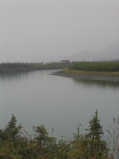
WThe Indian River is a river in Yukon, Canada. It is in the Bering Sea drainage basin and is a right tributary of the Yukon River.
 W
WThe Innoko River is a 500-mile (800 km) tributary of the Yukon River in the U.S. state of Alaska. It flows north from its origin south of Cloudy Mountain in the Kuskokwim Mountains and then southwest to meet the larger river across from Holy Cross.
 W
WThe John River is a 125-mile (201 km) tributary of the Koyukuk River in the northern part of the U.S. state of Alaska. It was named after John Bremner, a prospector and explorer who was one of the first non-native persons to go there. It flows south from Anaktuvuk Pass in Alaska's Brooks Range, into the larger river at a point near Bettles, slightly north of the Arctic Circle.
 W
WThe Kandik River is an 82-mile (132 km) tributary of the Yukon River in Canada and the United States. Beginning in the Canadian territory of Yukon, it flows generally southwest into the U.S. state of Alaska. Continuing southwest, it enters the larger river slightly upstream of the mouth of the Charley River in Yukon–Charley Rivers National Preserve.
 W
WThe Kantishna River is a 108-mile (174 km) tributary of the Tanana River in the U.S. state of Alaska. Formed by the confluence of the McKinley River with Birch Creek in Denali National Park and Preserve, it drains part of the north slope of the Alaska Range including the Denali massif. The direction of flow is generally north-northeast. The Toklat River is a major tributary.
 W
WThe Kanuti is a 175-mile (282 km) tributary of the Koyukuk River in the U.S. state of Alaska. The river begins near the Arctic Circle and flows generally west, passing under the Dalton Highway near Caribou Mountain. After continuing through a relatively flat basin, it enters a 1,200-foot (370 m) deep canyon before meeting the larger river near Allakaket. The Kanuti National Wildlife Refuge covers a large part of the river basin.
 W
WThe Klondike River is a tributary of the Yukon River in Canada that gave its name to the Klondike Gold Rush. The Klondike River has its source in the Ogilvie Mountains and flows into the Yukon River at Dawson City.
 W
WThe Koyukuk River is a 425-mile (684 km) tributary of the Yukon River, in the U.S. state of Alaska. It is the last major tributary entering the Yukon before the larger river empties into the Bering Sea.
 W
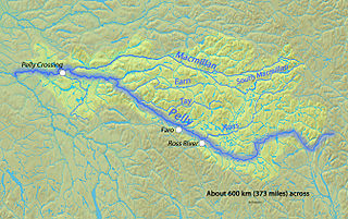
WThe Macmillan River is a tributary, approximately 320 kilometres (200 mi) long, of the Pelly River in the Yukon Territory of northwestern Canada. It originates in the Mackenzie Mountains and flows in a generally westward direction. The river's watershed extends over 13,800 square kilometres (5,300 sq mi) and its average discharge is about 190 cubic metres per second (6,700 cu ft/s).
WThe Melozitna River is a 135-mile (217 km) tributary of the Yukon River in the U.S. state of Alaska. It flows generally southwest from the Ray Mountains to its mouth near the city of Ruby.
WThe Nabesna River is a 73-mile (117 km) tributary of the Tanana River in the U.S. state of Alaska. Beginning at Nabesna Glacier in the Alaska Range, it flows north-northeast from Wrangell–St. Elias National Park and Preserve to join the Chisana River near Northway Junction. The combined rivers form the Tanana.
WThe Nenana River is a tributary of the Tanana River, approximately 140 miles (230 km) long, in central Alaska in the United States. It drains an area on the north slope of the Alaska Range on the south edge of the Tanana Valley southwest of Fairbanks.
WThe North Fork of the Koyukuk River is one of the principal forks of the Koyukuk River, approximately 105 mi (160 km) long, in northern Alaska in the United States. It has a watershed area of 1,850 square miles (4,800 km2). It rises on the south slopes of the Continental Divide in the Brooks Range.
 W
WThe Nowitna River is a 250-mile (400 km) tributary of the Yukon River in the U.S. state of Alaska. The river flows northeast from the Kuskokwim Mountains through Nowitna National Wildlife Refuge and enters the larger river 38 miles (61 km) northeast of Ruby and southwest of Tanana. Major tributaries include the Titna, Big Mud, Little Mud, Lost, and Sulatna rivers.
WOld Crow River is a transnational stream, 282 kilometres (175 mi) long, that begins in the U.S. state of Alaska and flows generally southeast to meet the Porcupine River in the Canadian territory of Yukon. In turn, the Porcupine, a tributary of the Yukon River, flows back into the United States, and its water eventually reaches the Bering Sea.
 W
WThe Pelly River is a river in Canada, and is a headstream of the Yukon River. The river originates west of the Mackenzie Mountains and flows 530 km (329 mi) long through the south central Yukon. The Pelly has two main tributaries, the Ross and Macmillan rivers.
 W
WThe Porcupine River is a 916 km (569 mi) tributary of the Yukon River in Canada and the United States. It begins in the Ogilvie Mountains north of Dawson City, Yukon, Canada. From there it flows north through the community of Old Crow, veers southwest into the U.S. state of Alaska, and enters the larger river at Fort Yukon. It derives its name from the Gwich'in word for the river, Ch'oonjik, or "Porcupine Quill River".
WThe Salcha River is a 125-mile (201 km) tributary of the Tanana River in the U.S. state of Alaska. Rising in the eastern part of the Fairbanks North Star Borough east of Fort Wainwright, it flows generally west-southwest to meet the larger river at Aurora Lodge, 33 miles (53 km) southeast of Fairbanks.
 W
WThe Sheenjek River is a 200-mile (320 km) tributary of the Porcupine River in the U.S. state of Alaska. It begins in the eastern part of the Brooks Range and flows southward to meet the larger river northeast of Fort Yukon.
 W
WThe Stewart River is a 533-kilometre (331 mi) tributary of Yukon River in the Yukon Territory of Canada. It originates in the Selwyn Mountains, which stand on the border between the Northwest Territories and the Yukon Territory. From there, the Stewart flows west, past the village of Mayo. The river is crossed by the Klondike Highway at the village of Stewart Crossing, and the highway parallels the river westward for about 56 kilometres (35 mi). After leaving the highway, the river travels southwest until it intersects the Yukon River 112 kilometres (70 mi) south of Dawson City. The mostly abandoned village of Stewart River is located at the mouth of the river.
 W
WThe Takhini River is a watercourse in Yukon, Canada. The river is located just north of Whitehorse, Yukon, and flows from west to east, meeting the Yukon River at a point between Whitehorse and Lake Laberge. During the winter, the river freezes and serves as part of the route of the Yukon Quest sled dog race.
 W
WThe Tanana River is a 584-mile (940 km) tributary of the Yukon River in the U.S. state of Alaska. According to linguist and anthropologist William Bright, the name is from the Koyukon (Athabaskan) tene no, tenene, literally "trail river".
 W
WThe Teslin River is a river in southern Yukon Territory and northwestern British Columbia, Canada, that flows 632 kilometres (393 mi) from its source south of Teslin Lake to its confluence with the Yukon River.
 W
WThe White River is a tributary about 200 miles (320 km) long, of the Yukon River in the U.S. state of Alaska and the Canadian territory of Yukon. The Alaska Highway crosses the White River near Beaver Creek.
WThe Wind River is a tributary of the East Fork Chandalar River in the U.S. state of Alaska. It arises in the Philip Smith Mountains of the Brooks Range and flows into the East Fork and eventually into the Yukon River.