 W
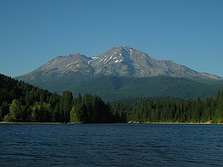
WThe Shasta–Trinity National Forests are federally designated forests in northern California, United States. Combined, they are the largest National Forest in California and are managed by the U.S. Forest Service. The 2,210,485 acre combined-forest encompasses five wilderness areas, hundreds of mountain lakes and 6,278 miles (10,103 km) of streams and rivers. Major features include Shasta Lake, the largest man-made lake in California and Mount Shasta, elevation 14,179 feet (4,322 m).
 W
WCampanula shetleri is a rare species of bellflower known by the common name Castle Crags bellflower. The plant is named for Castle Crags, a mountain formation in its limited native range, within the Shasta-Trinity National Forest.
 W
WEriogonum alpinum is a species of wild buckwheat known by the common name Trinity buckwheat.
 W
WEriogonum siskiyouense is a rare species of wild buckwheat known by the common name Siskiyou buckwheat.
 W
WIvesia longibracteata is a rare species of flowering plant in the rose family known by the common names Castle Crags ivesia and longbract mousetail. It is endemic to Shasta County, California, where it is known only from Castle Crags. It grows in rocky granite habitat in the temperate coniferous forest.
 W
WThe Bigfoot Trail is an unofficial U.S. long-distance hiking trail in northern California. The Bigfoot Trail was originally proposed by Michael Kauffmann in 2009 as a suggested route to navigate the Klamath Mountains from south to north as well as a long-trail to introduce nature lovers to the biodiversity of the Klamath Mountains region. The trail begins in the Yolla Bolly-Middle Eel Wilderness and ends in Redwood National Park at the Pacific Ocean near Crescent City, California. A major focus along the trail is conifer diversity, passing 32 species in 360 miles (580 km). The route crosses six wilderness areas, one National Park, and one State Park. Northwest California's Klamath Mountains foster one of the most diverse temperate coniferous forests on Earth, and this route is intended to be a celebration of that biodiversity.
 W
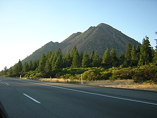
WBlack Butte is a cluster of overlapping dacite lava domes in a butte, a satellite cone of Mount Shasta. It is located directly adjacent to Interstate 5 at milepost 742 between the city of Mount Shasta and Weed, California. The highway crosses a 3,912 ft (1,192 m) pass, Black Butte Summit, at the western base of the lava domes. The lava domes were extruded at the foot of the cone of Shastina following the period of its major eruptions about 9,000–10,000 years ago.
 W
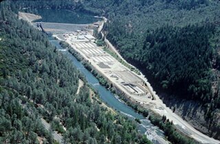
WBox Canyon Dam is a concrete gravity dam on the Upper Sacramento River impounding Lake Siskiyou reservoir, in Siskiyou County, northern California.
 W
WState Route 299 is an east–west state highway in the state of California that runs across the northern part of the state. At 305.777 miles (492.100 km), it is the third longest California state highway. Route 299 begins at US 101 at the northern edge of Arcata and continues in an easterly direction through to the Nevada state line. Between Arcata and Redding, Route 299 intersects with State Route 96, and is briefly co-signed with State Route 3. In Redding, it intersects with State Route 273, State Route 44, and Interstate 5. East of Redding, it intersects with State Route 89, and a section is co-signed with State Route 139 before reaching Alturas. It is then co-signed with U.S. Route 395 northeast of Alturas, and then runs east toward the border with Nevada. A ghost town, Vya, Nevada, can be reached via this route, which after the border becomes a dirt road, which was formerly Nevada State Route 8A.
 W
WCastle Crags is a dramatic and well-known rock formation in Northern California. Elevations range from 2,000 feet (610 m) along the Sacramento River near the base of the crags, to over 6,500 feet (2,000 m) at the summit of the tallest crag.
 W
WThe Castle Crags Wilderness is a 12,232-acre (49.50 km2) wilderness area in the Castle Crags rock formations of the Trinity Mountains, and within the Shasta-Trinity National Forest, in northwestern California. It is located in Siskiyou County and Shasta County, 40 miles (64 km) north of Redding and south of Mount Shasta City.
 W
WCastle Lake is a glacial lake located in the Trinity Mountains, in Siskiyou County of northern California. It is west of Mount Shasta City and Mount Shasta peak.
 W
WChaenactis suffrutescens is a species of flowering plant in the aster family known by the common name Shasta chaenactis.
 W
WChanchelulla Wilderness is an 8,062-acre wilderness area under the jurisdiction of the Shasta-Trinity National Forest in the U.S. state of California. Established in 1984, the Wilderness is centered around Chanchelulla Peak standing at 6,399 feet. The southern slopes are covered in thickets of chaparral while the northern slopes hold pockets of pine, fir, and cedar. Wildlife in the area include deer, American black bears, fishers, North American cougars, birds of prey, owls, and numerous songbirds.
 W
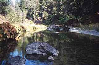
WClear Creek is a tributary of the upper Sacramento River in northern California.
 W
WHayfork Creek is a tributary of the South Fork Trinity River in Northern California in the United States. At over 50 miles (80 km) long, it is the river's longest tributary and is one of the southernmost streams in the Klamath Basin. It winds through a generally steep and narrow course north then west through the forested Klamath Mountains, but also passes through the Hayfork and Hyampom Valleys, which are the primary agricultural regions of Trinity County.
 W
WLake Britton is a reservoir located in Shasta County, California. It is known for its wide variety of bass and trout. Its main body is situated to the west of State Route 89, and is mostly surrounded by PG&E Land, Forest Service Land, and McArthur-Burney Falls Memorial State Park. Along the north shore lies North Shore and Dusty Campgrounds. It is fed by the Pit River and has tributaries of Clark Creek, Burney Creek, and Hat Creek and is impounded by the Pit #3 Dam.
 W
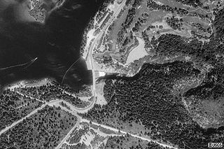
WLake McCloud is a reservoir on the McCloud River in Northern California. The lake forms behind an earthen dam finished in 1965 by the Pacific Gas and Electric Company to control water flows and for generating hydro-electric power. McCloud Dam is 235 feet high, 630 feet long at its crest, and impounds a maximum capacity of 35,200 acre-feet.
 W
WLewiston Lake is a reservoir impounded by Lewiston Dam on the Trinity River, in Trinity County, California.
 W
WMount Linn, at 8,098 feet (2,468 m), is the easternmost summit of South Yolla Bolly Mountain, and is located in the Yolla Bolly Mountains of the Northern Coast Ranges and sibling Klamath Mountains System, in Tehama County, northwestern California. Mt. Linn is the highest peak in the northern California Coast Ranges south of the Trinity Alps and, along with the highest peaks of the Trinity Alps, the tallest coastal range peak within the coterminous forty-eight states. Mt. Linn is the third most prominent peak in the northern Pacific Coast Ranges behind Mt. Eddy and Caesar Peaks in the Trinity Alps and Mt. Olympus of Washington's Olympic Mountains.
 W
WThe McCloud River is a 77.1-mile (124.1 km) long river that flows east of and parallel to the upper Sacramento River, in Siskiyou County and Shasta County in northern California in the United States. Protected under California's Wild and Scenic Rivers Act (1972), it drains a scenic mountainous area of the Cascade Range, including part of Mount Shasta. It is a tributary of the Pit River, which in turn flows into the Sacramento River. The three rivers join in Shasta Lake, formed by Shasta Dam north of Redding.
 W
WMount Eddy is the highest peak of the Trinity Mountains, a mountain range of the Klamath Mountains System, located in Siskiyou County, and Trinity County in northern California.
 W
WMount Shasta Ski Park is a ski resort located in northern California which has summer operations including Scenic Chairlift Rides, Mountain Biking, Disc Golf, just east of Interstate 5 along SR 89 between the city of Mount Shasta and the town of McCloud. The ski area lies about 6 mi (9.7 km) south of the summit of 14,179 ft (4,322 m) Mount Shasta, the second highest volcano in the Cascade Range behind Mt. Rainier. It straddles several small volcanic buttes on the lower southern flanks of the massive stratovolcano, with 3 triple chairlifts running to the top of Coyote Butte- 6,880 ft (2,100 m), Douglas Butte- 6,600 ft (2,000 m), and Marmot Ridge- 6,150 ft (1,870 m). Along with 2 magic carpets, one for tubing and one for learning to ski and snowboard. With a total skiable area of 425 acres and 32 conventional trails. The total skiable vertical is 1,435 ft (437 m), with 20% of the terrain rated beginner, 55% intermediate, and 25% advanced.
 W
WThe Mount Shasta Wilderness is a 38,200-acre (155 km2) federally designated wilderness area located 5 miles (8.0 km) east of Mount Shasta City in northern California. The US Congress passed the 1984 California Wilderness Act that set aside the Mount Shasta Wilderness. The US Forest Service is the managing agency as the wilderness is within the Shasta-Trinity National Forest. The area is named for and is dominated by the Mount Shasta volcano which reaches a traditionally quoted height of 14,162 feet (4,317 m) above sea level, but official sources give values ranging from 14,104 feet (4,299 m) from one USGS project, to 14,179 feet (4,322 m) via the NOAA. Mount Shasta is one of only two peaks in the state over 14,000 feet (4,300 m) outside the Sierra Nevada Mountain Range. The other summit is White Mountain Peak in the Great Basin of east-central California.
 W
WNorth Yolla Bolly Mountain is a 7,868-foot (2,398 m) peak in the Klamath Mountains of the Coast Ranges located in Trinity County, Northern California. The mountain is located in an isolated part of the Yolla Bolly-Middle Eel Wilderness, in the Shasta-Trinity National Forest, about 50 miles (80 km) west of Red Bluff. It is situated about 13 miles (21 km) from Mount Linn, the highest point of the Coast Ranges south of the Trinity Alps.
 W
WThe Pit River is a major river draining from northeastern California into the state's Central Valley. The Pit, the Klamath and the Columbia are the only three rivers in the U.S. that cross the Cascade Range.
 W
WThe Sacramento River is the principal river of Northern California in the United States and is the largest river in California. Rising in the Klamath Mountains, the river flows south for 400 miles (640 km) before reaching the Sacramento–San Joaquin River Delta and San Francisco Bay. The river drains about 26,500 square miles (69,000 km2) in 19 California counties, mostly within the fertile agricultural region bounded by the Coast Ranges and Sierra Nevada known as the Sacramento Valley, but also extending as far as the volcanic plateaus of Northeastern California. Historically, its watershed has reached as far north as south-central Oregon where the now, primarily, endorheic (closed) Goose Lake rarely experiences southerly outflow into the Pit River, the most northerly tributary of the Sacramento.
WThe Salmon Mountains are a subrange of the Klamath Mountains in Siskiyou County, northwestern California.
WThe Scott Mountains are a subrange of the Klamath Mountains located in Siskiyou County, in northwestern California. A high point is Scott Mountain Summit, a mountain gap-pass at 5,554 feet (1,693 m) in elevation.
 W
WShasta Lake, also popularly known as Lake Shasta, is a reservoir in Shasta County, California, United States. It began to store water in 1944 due to the impounding of the Sacramento River by Shasta Dam, the ninth tallest dam in the United States.
 W
WThe Shasta River is a tributary of the Klamath River, approximately 58 miles (93 km) long, in northern California in the United States. It drains the Shasta Valley on the west and north sides of Mount Shasta in the Cascade Range.
WThe Shasta River is a tributary of the Klamath River, approximately 58 miles (93 km) long, in northern California in the United States. It drains the Shasta Valley on the west and north sides of Mount Shasta in the Cascade Range.
 W
WThe Cascade Range or Cascades is a major mountain range of western North America, extending from southern British Columbia through Washington and Oregon to Northern California. It includes both non-volcanic mountains, such as the North Cascades, and the notable volcanoes known as the High Cascades. The small part of the range in British Columbia is referred to as the Canadian Cascades or, locally, as the Cascade Mountains. The latter term is also sometimes used by Washington residents to refer to the Washington section of the Cascades in addition to North Cascades, the more usual U.S. term, as in North Cascades National Park. The highest peak in the range is Mount Rainier in Washington at 14,411 feet (4,392 m).
 W
WMount Shasta is a potentially active volcano at the southern end of the Cascade Range in Siskiyou County, California. At an elevation of 14,179 feet (4321.8 m), it is the second-highest peak in the Cascades and the fifth-highest in the state. Mount Shasta has an estimated volume of 85 cubic miles (350 km3), which makes it the most voluminous stratovolcano in the Cascade Volcanic Arc. The mountain and surrounding area are part of the Shasta–Trinity National Forest.
 W
WThe South Fork Trinity River is the main tributary of the Trinity River, in the northern part of the U.S. state of California. It is part of the Klamath River drainage basin. It flows generally northwest from its source in the Klamath Mountains, 92 miles (148 km) through Humboldt and Trinity Counties, to join the Trinity near Salyer. The main tributaries are Hayfork Creek and the East Branch South Fork Trinity River. The river has no major dams or diversions, and is designated Wild and Scenic for its entire length.
 W
WThe Spring Creek Reservoir is the artificial lake created by the construction of the Spring Creek Dam across Spring Creek in the Shasta-Trinity National Forest of Shasta County, California, adjacent to Keswick.
WThe Trinity Alps are a mountain range in Siskiyou County and Trinity County, in Northern California. They are a subrange of the Klamath Mountains and located to the north of Weaverville.
 W
WThe Trinity Alps Wilderness is a 525,627-acre (212,714 ha) designated wilderness located in northern California, roughly between Eureka and Redding. It is jointly administered by Shasta-Trinity, Klamath, and Six Rivers National Forests. About 4,623 acres (1,871 ha) are administered by the Bureau of Land Management. The wilderness is located in the Salmon and Scott Mountains, subranges of the Klamath Mountains region. The high, granitic and ultramafic peaks of the eastern half of the wilderness area are known as the Trinity Alps. Granite peaks at the core of the area are known as the White Trinities, reddish ultramafic peaks in the southeast are known as the Red Trinities, and the forested mountains in the western half of the wilderness are known as the Green Trinities.
 W
WTrinity Lake, previously called Clair Engle Lake, is an artificial lake on the Trinity River formed by the Trinity Dam and located in Trinity County, California, United States. The dam was built by the U.S. Bureau of Reclamation. The lake's capacity is 2,447,650 acre⋅ft (3,019.13 GL), making it one of the largest reservoirs in California. The lake's surface is at 2,370 ft (720 m) above MSL. Trinity Lake captures and stores water for the Central Valley Project, which provides the Central Valley with water for irrigation and produces hydroelectric power. This lake is known for its many small arms, glassy inlets, and great water-skiing conditions.
 W
WThe Trinity Mountains are a subrange of the Klamath Mountains, one of the ranges within the California Coast Ranges and part the greater Pacific Coast Ranges, the coastal mountain system extending from Mexico to Alaska. The Trinity Mountains subrange rises in Siskiyou County and eastern Trinity County, Northern California.
 W
WThe Trinity River is a major river in northwestern California in the United States, and is the principal tributary of the Klamath River. The Trinity flows for 165 miles (266 km) through the Klamath Mountains and Coast Ranges, with a watershed area of nearly 3,000 square miles (7,800 km2) in Trinity and Humboldt Counties. Designated a National Wild and Scenic River, along most of its course the Trinity flows swiftly through tight canyons and mountain meadows.
WState Route 299 is an east–west state highway in the state of California that runs across the northern part of the state. At 305.777 miles (492.100 km), it is the third longest California state highway. Route 299 begins at US 101 at the northern edge of Arcata and continues in an easterly direction through to the Nevada state line. Between Arcata and Redding, Route 299 intersects with State Route 96, and is briefly co-signed with State Route 3. In Redding, it intersects with State Route 273, State Route 44, and Interstate 5. East of Redding, it intersects with State Route 89, and a section is co-signed with State Route 139 before reaching Alturas. It is then co-signed with U.S. Route 395 northeast of Alturas, and then runs east toward the border with Nevada. A ghost town, Vya, Nevada, can be reached via this route, which after the border becomes a dirt road, which was formerly Nevada State Route 8A.
 W
WThe Whiskeytown–Shasta–Trinity National Recreation Area is a United States National Recreation Area in northern California.
WThe Yolla Bolly–Middle Eel Wilderness is a federally designated wilderness area in the Yolla Bolly Range of the southern Klamath Mountains and the Inner Northern California Coast Ranges, in Northern California.