 W
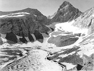
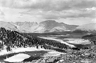
WThe John Muir Wilderness is a wilderness area that extends along the crest of the Sierra Nevada of California for 90 miles (140 km), in the Inyo and Sierra National Forests. Established in 1964 by the Wilderness Act and named for naturalist John Muir, it contains 581,000 acres (2,350 km2). The wilderness lies along the eastern escarpment of the Sierra from near Mammoth Lakes and Devils Postpile National Monument in the north, to Cottonwood Pass near Mount Whitney in the south. The wilderness area also spans the Sierra crest north of Kings Canyon National Park, and extends on the west side of the park down to the Monarch Wilderness.
 W
WMount Abbot is a mountain in California's Sierra Nevada, in the John Muir Wilderness. It is located between Mount Mills and Mount Dade along the Sierra Crest and straddles the border between Fresno and Inyo counties.
 W
WMount Agassiz, at 13,899 feet (4,236 m), is one of the twenty highest peaks of California. It is the northernmost and easiest to climb of the major Palisades summits. This peak is not to be confused with the 9967ft peak by the same name in Desolation Wilderness, also in the California Sierra.
 W
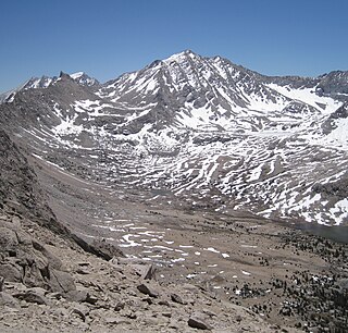
WBasin Mountain in California's eastern Sierra Nevada range is a large and visually prominent peak near the city of Bishop. Basin Mountain is not as high as its neighboring peaks, Mount Tom and Mount Humphreys, but it dominates the view to the west from Bishop as it rises above the Buttermilks. It is a relatively easy scramble to the top. The summit is not especially notable, except for the wonderful views it offers of Mount Tom, which dominates the skyline just to the north. The night-time views of Bishop and the Owens valley are spectacular.
 W
WMount Baxter is a peak along the crest of the Sierra Nevada in California. Mount Baxter is on the boundary between Kings Canyon National Park and the John Muir Wilderness just north of Baxter Pass and to the northeast of the Rae Lakes, a popular backpacking destination along the John Muir Trail.
 W
WBirch Mountain, or Paokrung, is one of the fifty highest peaks of California. Of the major peaks of the Palisades, it stands farthest from the Sierra Crest.
 W
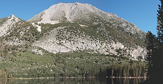
WBloody Mountain is located in the Sierra Nevada 1 mile South East of Mammoth Lakes in eastern California in the southwestern United States.
 W
WMount Darwin is a flat-topped mountain in the Sierra Nevada, on the border of between Fresno and Inyo counties in Kings Canyon National Park and the John Muir Wilderness of California.
 W
WMount Gould is a thirteener on the Sierra crest, just north of the Kearsarge Pass.
 W
WMount Hopkins is a mountain in the John Muir Wilderness north of Kings Canyon National Park. It is one of four peaks that surround Pioneer Basin, 1.4 miles (2.3 km) south-southeast of Mount Crocker, 2 miles (3.2 km) west-southwest of Mount Huntington, and 2 miles (3.2 km) southwest of Mount Stanford. The mountain was named for Mark Hopkins, one of the builders of the Central Pacific Railroad.
 W
WMount Humphreys is a mountain peak in the Sierra Nevada on the Fresno-Inyo county line in the U.S. state of California. It is the 14th highest peak in California, and the highest peak in the Bishop area. The mountain was named by the California Geological Survey of 1873 for Andrew A. Humphreys, the chief engineer of the United States Army at the time.
 W
WMount Huntington is a mountain in the John Muir Wilderness north of Kings Canyon National Park. It is one of four peaks that surround Pioneer Basin, 5 miles (8.0 km) northwest of Mount Crocker, 2 miles (3.2 km) northeast of Mount Hopkins, and 1.8 miles (2.9 km) south-southwest of Mount Stanford. The mountain was named for Collis Potter Huntington, one of the builders of the Central Pacific Railroad.
WMount Irvine is a mountain in the Sierra Nevada of California. The summit is in Inyo National Forest and the John Muir Wilderness. The peak was named in memory of Andrew Irvine, of the 1924 British Mount Everest expedition, who perished on Mount Everest, June, 1924. Norman Clyde proposed Irvine's and George H. Leigh Mallory's names following their loss after attaining the highest altitude reached by a mountaineer.
 W
WJunction Peak is a thirteener in the Sierra Nevada. Joseph Nisbet LeConte chose this name in 1896, noting that it marks the point where the Sierra Crest crosses the water divide of the Kern and Kings rivers. Today it also is the boundary between Inyo and Tulare counties, and of Kings Canyon National Park, Sequoia National Park and the John Muir Wilderness.
WMount Keith is a mountain on the crest of California's Sierra Nevada, between Mount Bradley to the north, and Junction Peak to the southwest. Its north and west facing slopes feed the Kings River watershed by way of Bubbs Creek, and its east and south slopes feed the Owens River via Shepherd Creek. By the same dividing line, Keith stands on the boundary of Kings Canyon National Park to the northwest, and the John Muir Wilderness to the southeast. It is a thirteener, a mountain which has a height over 13000 feet.
 W
WMount Langley is located on the crest of the Sierra Nevada, on the boundary between Inyo and Tulare counties, in eastern California in the southwestern United States. To the east is Owens Valley, and to the west is the Kern River Valley. It is the ninth-highest peak in the state and the seventh-highest in the Sierra. Mount Whitney, the highest peak in the contiguous United States, lies 4.8 miles (7.7 km) to the northwest. Mt. Langley also has the distinction of being the southernmost fourteener in the United States.
 W
WLaurel Mountain is a peak in Mono County, California. It lies in the Sherwin Range of the Sierra Nevada and is in the Inyo National Forest and the John Muir Wilderness. It reaches a height of 11,818 feet (3,602 m) and is largely composed of metamorphic rock caused by contact with an intruding pluton in the late Cretaceous.
 W
WMount Le Conte is a mountain located in the Sierra Nevada of California. The boundary between Inyo and Tulare counties runs along the crest of the Sierra, across Mount Le Conte. The mountain was named in 1895 for Joseph Le Conte (1823–1901), the first professor of geology and natural history at the University of California.
 W
WLone Pine Peak is located on the east side of the Sierra Nevada range just west of the town of Lone Pine, California in Inyo County, in eastern California in the southwestern United States. The summit marks the eastern boundary of the John Muir Wilderness in the Inyo National Forest. Lone Pine Peak is the mountain in the photo for the default desktop of macOS Sierra.
WMount Mallory is a mountain located in the Sierra Nevada of California. The boundary between Inyo National Forest and Sequoia National Park runs across the summit. The peak was named in memory of George H. Leigh Mallory, of the 1924 British Mount Everest expedition, who was lost on Mount Everest, June, 1924. Norman Clyde advanced Mallory's and Andrew Irvine's names following their loss after attaining the highest altitude reached by a mountain climber.
WMount Mary Austin is a mountain east of the Sierra Crest and west of Independence, California. It is named in honor of Mary Hunter Austin, the author of The Land of Little Rain and natural historian who lived in Independence. The mountain is in the John Muir Wilderness. Special permits to enter this area have been required in the past since it is habitat for the Sierra Nevada bighorn sheep, an endangered species. Check locally for current information. The U.S. Forest Service does not advice the use of pack goats in this area.
WMount McAdie is summit on the crest of the Sierra Nevada, and is located 2.1 miles (3.4 km) south of Mount Whitney. It has three summits, with the north peak being the highest. The summit ridge marks the boundary between Sequoia National Park and the John Muir Wilderness. It is also on the boundary between Inyo and Tulare counties. Lone Pine, 12.4 miles (20.0 km) to the northeast, is in the Owens Valley on U.S. 395.
 W
WMiddle Palisade is a peak in the Palisades group, part of the central Sierra Nevada mountain range in the U.S. state of California. It is the twelfth highest peak in the state.
 W
WMount Mills is a Thirteener and California 4000 meter peak, on the Sierra Crest, north of Mount Abbot and south of Mono Pass in the Sierra Nevada.
 W
WMount Morgan is a mountain located in northwestern Inyo County, California, in the John Muir Wilderness of the Inyo National Forest.
 W
WMount Morgan is a highest point on Nevahbe Ridge in the Sherwin Range of the Sierra Nevada. It lies in Mono County, California, between McGee Canyon and Hilton Lakes. The mountain is in the John Muir Wilderness Area in the Inyo National Forest.
 W
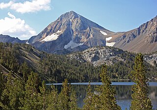
WMount Morrison is located in the Sierra Nevada, in the Sherwin Range. It rises south of Convict Lake near the town of Mammoth Lakes.
 W
WMount Muir is a peak in the Sierra Nevada of California, 0.95 miles (1.5 km) south of Mount Whitney. This 14,018-foot (4,273 m) peak is named in honor of Scottish-born John Muir, a famous geologist, conservationist and founder of the Sierra Club. The southernmost section of the John Muir Trail contours along the west side of Mount Muir near its summit and ends on the summit of Mount Whitney.
 W
WNorman Clyde Peak, standing 13,861 feet (4,225 m) tall, is in natural company among the high peaks of the Palisades region of the Sierra Nevada in California. It raises on the main ridge of the Palisades', between Middle Palisade and Palisade Crest. Norman Clyde Glacier on its north face, and Middle Palisade Glacier on its east both feed the headwaters of the South Fork of Big Pine Creek. It is named posthumously for mountaineer Norman Clyde, who first climbed it by way of the Norman Clyde Glacier in 1930.
 W
WNorth Palisade is the third highest mountain in the Sierra Nevada range of California. It is the highest peak of the Palisades group of peaks in the central part of the range. It sports a small glacier and several highly prized rock climbing routes on its northeast side.
 W
WPalisade Crest is a jagged ridge in The Palisades's region of the Sierra Nevada southeast of Mount Sill and northwest of Middle Palisade. Its twelve pinnacles are unofficially named for characters from The Lord of the Rings by J. R. R. Tolkien. The highest pinnacle, at 13,559 feet (4,133 m), is called Gandalf Peak.
 W
WRed Slate Mountain is a summit in the Sierra Nevada. It lies along the Sierra Crest that divides Fresno County from Mono County, California.
WRuby Peak is a thirteener on the Sierra Crest, north of Mount Mills. It is in the John Muir Wilderness and on the boundary between the Sierra National Forest and the Inyo National Forest. It is near Mono Pass. The eastern slope drains into Rock Creek which feeds the Owens River while the western slopes drains in Mono Creek which feeds the South Fork of the San Joaquin River.
 W
WMount Russell is a peak in the Sierra Nevada mountain range in the U.S. state of California, about 0.8 miles (1.3 km) north of Mount Whitney. It rises to an elevation of 14,094 feet (4,296 m) and is the seventh-highest peak in the state.
 W
WMount Sill is one of the fourteeners of the Sierra Nevada in California. It is located in the Palisades, a group of striking rock peaks with a few small glaciers on their flanks. Mount Sill is located 0.6 miles (1 km) east of North Palisade, the high point of the group. The two peaks are connected by a high, rocky ridge, on the north side of which lies the Palisade Glacier. Mount Sill lies on the main Sierra Crest, but is at a point where the crest turns sharply, giving it particularly striking summit views. On one side is Kings Canyon National Park and Fresno County; on the other is the John Muir Wilderness, Inyo National Forest and Inyo County.
 W
WSplit Mountain is a fourteener in the Sierra Nevada of the U.S. state of California, near the southeast end of the Palisades group of peaks. It is the only fourteener in the watershed of the South Fork Kings River, and rises to 14,064 ft (4,287 m), making it the eighth-highest peak in the state.
 W
WTemple Crag is a popular rock climbing destination in the Palisades region of the Sierra Nevada. It straddles the drainages of the North and South Forks of Big Pine Creek.
 W
WThunderbolt Peak is a peak in the Palisades group of peaks in the Sierra Nevada in the U.S. state of California. It rises to 14,009 feet (4,270 m) and could be considered the thirteenth-highest peak in the state, but since the peak has less than 300 feet (91 m) of prominence it is usually considered a subsidiary peak of North Palisade. But if it is considered a separate mountain peak, Thunderbolt Peak is the northernmost fourteener in the Sierra Nevada.
 W
WMount Tom is a large and prominent peak near the city of Bishop in Inyo County of eastern California. It is in the Sierra Nevada and east of the Sierra Crest. The mountain is also in the John Muir Wilderness.
 W
WMount Tyndall is a peak in the Mount Whitney region of the Sierra Nevada in the U.S. state of California. It rises to 14,025 feet (4,275 m), and is the tenth highest peak in the state. The mountain was named in honor of the Irish scientist and mountaineer, John Tyndall.
 W
WUniversity Peak is a thirteener in the Sierra Nevada. It is named for the University of California. It is on the Sierra crest between Mount Gould to the north, and Mount Bradley to the south. It lies partly in Tulare County and partly in Inyo County. Its west side is in Kings Canyon National Park while the east face is in the John Muir Wilderness.
 W
WMount Whitney is the tallest mountain in the contiguous United States and the Sierra Nevada, with an elevation of 14,505 feet (4,421 m). It is in East–Central California, on the boundary between California's Inyo and Tulare counties, 84.6 miles (136.2 km) west-northwest of North America's lowest point, Badwater Basin in Death Valley National Park, at 282 ft (86 m) below sea level. The mountain's west slope is in Sequoia National Park and the summit is the southern terminus of the John Muir Trail, which runs 211.9 mi (341.0 km) from Happy Isles in Yosemite Valley. The eastern slopes are in Inyo National Forest in Inyo County.
 W
WMount Williamson, at 14,379 feet (4,383 m), is the second highest mountain in both the Sierra Nevada range and the state of California. It is the sixth highest peak in the contiguous United States.
 W
WMount Winchell, a thirteener, is among the thirty highest peaks of California. It is in the Palisades region of the Sierra Nevada, on the Sierra Crest between Mount Agassiz and Thunderbolt Peak.