 W
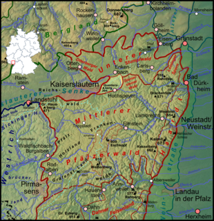
WThis list of mountains and hills in the Palatine Forest contains a selection of the highest or more notable peaks located in the natural region of the Palatine Forest in the German state of Rhineland-Palatinate.
 W
WThe Betzenberg is a 285-metre-high hill in the German city of Kaiserslautern. It rises about 50 metres above the city and gives its name to the quarter in which it stands. It was well known because it also gave its name to what is now the Fritz Walter Stadium.
 W
WThe Bichtenberg is a 400-metre-high hill in the western Wasgau, a region on the Franco-German border that includes the southern part of the Palatine Forest and the northern part of the Vosges. Its northwestern flank is in the parish of Lemberg, its southwestern flank in the parish of Dahn. To the north is the Lemberg hamlet of Salzwoog. Three kilometres west lies the Salzwoog Devil's Table.
 W
WThe Blättersberg near Rhodt unter Rietburg in the Rhenish-Palatine county of Südliche Weinstraße is a mountain, 613.2 m above sea level (NHN), in the Palatine Forest in the German state of Rhineland-Palatinate.
WThe Bloskülb is a 570-metre-high hill in the central part of the Palatine Forest of Germany. It lies about three kilometres northwest of the village of Iggelbach. It is located entirely within the territory of the municipality of Elmstein.
 W
WThe Bobenthaler Knopf is a hill, 534 m above sea level, in the southeastern Wasgau, the name given to the region covering the southern part of the Palatine Forest in Germany and the northern part of the Vosges in France.
 W
WThe Breitenberg near Sankt Martin in the Rhineland-Palatinate county of Südliche Weinstraße is a hill, 545.2 m above sea level (NHN), and subpeak of the Kalmit, the highest mountain in the Palatinate Forest. It is part of the Haardt mountains.
WThe Brogberg is a hill, 567 metres high, in the Palatine Forest in Germany. It is located west of Iggelbach, a village in the municipality of Elmstein. Northeast of the hill rises the Iggelbach stream, a left tributary of the Helmbach. The Brogberg lies entirely within the territory of the municipality of Elmstein.
 W
WThe Drachenfels is a hill in the northern part of the Palatine Forest in the German state of Rhineland-Palatinate) on the forest estate of the county town of Bad Dürkheim. At 570.8 m above sea level (NHN), it is the highest point of the Palatine Forest north of the Hochspeyerbach - Speyerbach line. The Drachenfels area has been designated as a nature reserve.
 W
WThe Eckkopf is a 516-metre-high (1,693 ft) hill in the Palatine Forest in the Germany state of Rhineland-Palatinate. It lies about 3 km west of the small Palatine town of Deidesheim in the Haardt, as the eastern edge of the Palatine Forest is called. It has a 25-metre-high (82 ft) observation tower called the Eckkopf Tower (Eckkopfturm).
 W
WThe Eschkopf near Hofstätten in the German state of Rhineland-Palatinate is a major hill, 608.3 m above sea level (NHN) high in the Palatine Forest.
 W
WThe Großer Eyberg is a 513-metre-high (1,683 ft) hill in the southern Palatine Forest in Germany. It lies in the county of Südwestpfalz in the borough of Dahn in an area known as the Dahner Felsenland, a part of the Wasgau, a region which comprises the southern part of the Palatine Forest and the northern part of the Vosges Mountains. It is the highest hill in the western Wasgau.
 W
WThe Großer Adelberg is a hill, 567 metres high, in the Central Palatinate Forest in Germany.
 W
WThe Heidenberg is a 420-metre-high hill in the southeastern Wasgau, the region that covers the southern part of the Palatinate Forest in Germany and the northern Vosges in France. The Heidenberg's north flank is in the parish of Busenberg, its south flank in the parish of Erlenbach bei Dahn.
 W
WThe Hochberg is a 635.3-metre-high mountain in the central Haardt in the Palatine Forest in Germany. It lies on the territory of the municipality of Sankt Martin (Palatinate) in the county of Südliche Weinstraße in the state of Rhineland-Palatinate. After the Kalmit, the Kesselberg and the Roßberg it is the fourth highest peak in the Palatine Forest.
WThe Hohe Bühl is a hill in the northern Palatine Forest in the German state of Rhineland-Palatinate, with a height of 444 m above sea level (NN).
 W
WThe Hohe Loog, is a mountain, 619 m above sea level (NN), in the Haardt, the eastern rim of the Palatine Forest in Germany. The mountain lies within the borough of Neustadt an der Weinstraße in the southern part of the state of Rhineland-Palatinate.
 W
WThe Hohenberg is a 552 m above sea level (NN) high hill in the Palatinate Forest, in the municipalities of Birkweiler, Queichhambach and Siebeldingen. At its summit is an observation tower, a refuge hut and starting ramps for hang gliders.
 W
WThe Hortenkopf is a hill, 606 metres above sea level (NN), in the German state of Rhineland-Palatinate, which lies in the middle of the Palatine Forest between Hofstätten and Leimen. The Hortenkopf is recognisable from a long way off thanks to the transmission tower that has been erected on its summit.
 W
WThe Humberg is a mountain in the south of Kaiserslautern, Germany, that stands on the border of the Palatinate forest. With a height of 425 meters, it is the highest point in the area of Kaiserslautern. At its peak, the Humberg Tower provides a dramatic view of the area below.
 W
WThe Hüttenberg near Maikammer in the Rhineland-Palatinate county of Südliche Weinstraße is a subpeak, 620.1 m above sea level (NN), of the Kalmit (672.6 m) the highest mountain in the Haardt in the eastern Palatinate Forest of Germany. There is a blockfield, the Hüttenberg Felsenmeer, along the crest.
 W
WThe Kalmit is the highest peak in the Palatinate Forest and the second highest in the Palatinate region of Germany. It is 672.6 m above sea level (NHN) and located 5.5 kilometres (3.4 mi) south of the town of Neustadt an der Weinstraße.
 W
WThe Kleine Kalmit is a hill, 270.5 m above sea level (NN) high, just outside the eastern edge of the Palatine Forest, and the Haardt range, in the German state of Rhineland-Palatinate. Parts of the hill have been designated as a Nature reserve bearing the same name.
 W
WThe Kesselberg near Edenkoben in the German state of Rhineland-Palatinate is a mountain, 661.8 m above sea level (NHN), It iis second highest peak in the Palatine Forest region after the Kalmit (672.6 m) and also the third highest mountain in the Palatinate region.
WThe Kieskautberg is a hill, 461 m, which is located 2 kilometres south of the German village of Carlsberg in the east of the Diemerstein Forest, which is part of the northern Palatine Forest.
 W
WThe Mosisberg near Hofstätten in the German state of Rhineland-Palatinate is a hill, 608.7 m above sea level (NHN), in the central Palatine Forest. It has two domes, the eastern one is the summit and is called Langer Kopf and the western high point is the Preußenstein.
 W
WThe Nestelberg is a 402-metre-high hill in the Dahner Felsenland in the Wasgau, a region that comprises the southern part of the Palatine Forest in the German state of Rhineland-Palatinate and the northern part of the French Vosges in the departments of Bas-Rhin and Moselle.
 W
WThe Orensberg, also known in the region as the Orensfels(en) due to the striking rock formations on its summit plateau, is a hill, 581.2 m above sea level (NHN), near Frankweiler in the county of Südliche Weinstraße in the German state of Rhineland-Palatinate. The hill is part of the Haardt mountain range that forms the eastern edge of the Palatinate Forest.
 W
WThe Peterskopf, near the Palatine county town of Bad Dürkheim in the German state of Rhineland-Palatinate, is a 487-metre-high hill in the Haardt mountains. On its summit is the Bismarck tower.
 W
WThe Queitersberg, more rarely spelt Quaidersberg, Quaitersberg or Queidersberg, is a 394-metre-high hill in the northern Palatine Forest in the German state of Rhineland-Palatinate. On a subpeak is the natural monument of the Felsplatt, a rock formation.
WThe Rahnfels is a hill in the Palatine Forest in Germany, about 2 kilometres northwest of the ruins of Hardenburg castle. With a summit height of 517 m above NN the Rahnfels is the highest point in the Palatine Forest north of the River Isenach.
 W
WThe Rehberg is a prominent hill, 576.8 m above sea level (NHN), in the German state of Rhineland-Palatinate. After the Grand Wintersberg (ca. 581 m) in French North Alsace, the Rehberg is the second highest hill in the Wasgau, the Franco-German region that forms the southern part of the Palatine Forest and runs from the valley of the River Queich to the Col de Saverne. The Rehberg is also the highest hill on German soil in the Wasgau. As part of the Palatine Forest-North Vosges Biosphere Reserve it has been placed under special protection measures.
 W
WThe Roßberg near Ramberg in the county of Südliche Weinstraße in the German state of Rhineland-Palatinate is, at 637 m above sea level (NHN), the third highest mountain in the Palatine Forest.
 W
WThe Schafkopf, with its height of 616.8 metres, is one of the few mountains of the Palatine Forest that exceeds the 600 metre mark. It lies south of the Forest's highest peak, the Kalmit, in the Palatine Forest-North Vosges Biosphere Reserve, not far from the municipality of St. Martin and, together with the Morschenberg (608 m), Rotsohlberg (607 m) and Steigerkopf (614 m), forms a contiguous massif. The Schafkopf is entirely forested. There are no official paths or tracks to the actual summit.
 W
WThe Schindhübel is a hill, 571 m above sea level (NN), that rises in the middle of the Palatine Forest in Germany, 5 kilometres southwest of Elmstein.
 W
WThe Steigerkopf, also colloquially called the Schänzel, near Edenkoben in the county of Südliche Weinstraße in the German state of Rhineland-Palatinate, is a mountain, 613.6 m above sea level (NHN), in the Palatine Forest. At the summit, which lies on the territory of Gommersheim, is the Schänzel tower.
 W
WThe Hohe Stoppelkopf, locally just called the Stoppelkopf, is a 566.2-metre-high hill in the Palatine Forest in the German state of Rhineland-Palatinate. It lies 3 km north of the small town of Lambrecht.
 W
WThe Taubenkopf is a hill, 603.8 m above sea level (NHN), in the German state of Rhineland-Palatinate. It is part of the mountain chain of the Haardt in the Palatine Forest and lies in the municipal territory of Diedesfeld in the borough of Neustadt an der Weinstraße.
 W
WThe Teufelsberg is a hill massif, 598 metres high, in the southern Palatinate Forest on the territory of Burrweiler in the county of Südliche Weinstraße. It has a subpeak, the Lambertskopf (539 m). The Teufelsberg offers extensive views over the Upper Rhine Plain. It is not accessible by motor vehicle but may be ascended on various hiking trails.
 W
WThe Teufelsstein in the Haardt mountains, near the Palatine county town of Bad Dürkheim in the German state of Rhineland-Palatinate, is a hill 317 m above sea level (NN). On its domed summit is a monolith of the same name. Traces of human activity on the rock indicate that it acted as a cult object in former times.
 W
WThe Weilerskopf is a hill, 470 metres high, in a wooded exclave of Herxheim am Berg northwest of the German town of Bad Dürkheim. Its summit is the site of a transmission tower owned by Deutsche Telekom.
 W
WThe Weinbiet is a hill, 554 m above sea level (NHN), in the borough of Neustadt an der Weinstraße in the German state of Rhineland-Palatinate and is one of the highest hills in the Haardt, the line of mountains and hills forming the eastern edge of the Palatine Forest and facing the Upper Rhine Plain. On the summit is an inn, the Weinbiethaus, a stone-built panorama tower with a weather station and a radio transmission mast.
 W
WThe Weißenberg in the Palatine Forest is a hill in the municipality of Merzalben. Its height is variously give as 610 m above sea level (NHN) or 607 m above NHN. The higher value has been officially recommended since 2011. That makes the Weißenberg the highest point in the west of the mountain range, ahead of the Eschkopf and Mosisberg. As part of the Palatine Forest-North Vosges Biosphere Reserve it is protected by special conservation measures.
 W
WThe Wetterkreuzberg is a hill in the Haardt range on the eastern edge of the Palatine Forest in the German state of Rhineland-Palatinate.