 W
WTied islands, or land-tied islands as they are often known, are landforms consisting of an island that is connected to land only by a tombolo: a spit of beach materials connected to land at both ends. St Ninian's Isle, in the Shetland Islands off the north coast of Scotland, is an example of this; it was once an island but is now linked to the Mainland. Other examples include: Maury Island, Washington in the Puget Sound, Coronado, California and Nahant, Massachusetts in the U.S.; Barrenjoey, New South Wales in Australia; and Wedge Island in Western Australia.
 W
WA tombolo is a sandy isthmus. A tombolo, from the Italian tombolo, meaning 'pillow' or 'cushion', and sometimes translated as ayre, is a deposition landform in which an island is attached to the mainland by a narrow piece of land such as a spit or bar. Once attached, the island is then known as a tied island.
 W
WAdam's Bridge, also known as Rama's Bridge or Rama Setu, is a chain of limestone shoals, between Pamban Island, also known as Rameswaram Island, off the south-eastern coast of Tamil Nadu, India, and Mannar Island, off the north-western coast of Sri Lanka. Geological evidence suggests that this bridge is a former land connection between India and Sri Lanka.
 W
WAp Lei Pai or Aberdeen Rock is an uninhabited island in Hong Kong, linked to the south of Ap Lei Chau in Hong Kong. It is located between the East Lamma Channel and Aberdeen Channel. It is under the administration of the Southern District.
 W
WAughinish is a small island and townland located in Oughtmama Parish of the Barony of Burren in north County Clare, in Ireland on the south shore of Galway Bay. By road it is 10.9 kilometres (6.8 mi) northwest of Kinvarra. The island is approximately two miles (3 km) wide and a mile (1.6 km) from the northernmost tip to the southernmost point and has approximately fifty inhabitants.
 W
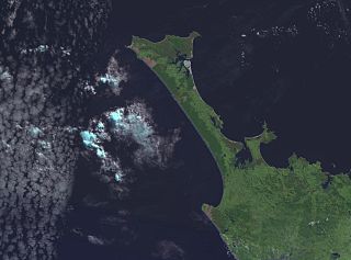
WThe Aupouri Peninsula is a tombolo at the northern tip of the North Island of New Zealand. It projects between the Tasman Sea to the west and the Pacific Ocean to the east. It constitutes the northern part of the Far North District, incorporating North Cape, Houhora and the northern half of Awanui.
 W
WBelkıs Tombolo is a tombolo in Marmara Sea of Turkey. It is in Balıkesir Province. At 40°22′N 27°53′E the tombolo connects Kapıdağ Peninsula to main land (Anatolia). The width of the tombolo is 1,700 metres (5,600 ft) and the length is 1,500 metres (4,900 ft). Bandırma Gulf is to the east and Erdek Gulf is to the west of the tombolo. The eastern shore is covered by sand dunes and the western shore is a sandy beach. The midpoint of the tombolo is a marshland. There are two highways across the tombolo from Bandırma in the mainland to the peninsula; One to the eastern coast and one to the western coast and Erdek.
 W
WThe Broulee Island Nature Reserve is a protected nature reserve located on the south coast of New South Wales, Australia. The 43 ha reserve was created in 1972 and is managed by the NSW National Parks & Wildlife Service. The reserve is situated 23 kilometres (14 mi) south of Batemans Bay and is adjacent to the village of Broulee.
 W
WChesil Beach, sometimes called Chesil Bank, in Dorset, southern England is one of three major shingle structures in Britain. Its name is derived from the Old English ceosel or cisel, meaning "gravel" or "shingle". It runs for a length of 29 kilometres (18 mi) from West Bay to the Isle of Portland and in places is up to 15 metres (50 ft) high 200 metres (660 ft) wide. Behind the beach is the Fleet, a shallow tidal lagoon. Both are part of the Jurassic Coast and a UNESCO World Heritage Site, and together form an SSSI and Ramsar Site.
 W
WThe Cronulla sand dunes, also known officially as the Cronulla Sand Dune and Wanda Beach Coastal Landscape, are a heritage-listed former sand mining, film making, pastoral property and visitor attraction and now nature conservation, open space and visitor attraction located on the Kurnell Peninsula at Lindum Road, Kurnell in the Sutherland Shire local government area of New South Wales, Australia. It is also known as Part of Kurnell Peninsula Headland and Cronulla Sand Hill. It was added to the New South Wales State Heritage Register on 26 September 2003.
 W
WFenit Island is a populated island, on the coast of County Kerry, connected to the mainland by a sandbar. Located in Tralee Bay, the island encloses Barrow Harbour. Historically, the area was called 'Fenit Within'. It is adjacent to the areas of 'Tawlacht' and 'Fenit Without' on the mainland. The terms within/without refer to the walled protection that surrounded parts of the island from attackers from the landward side.
 W
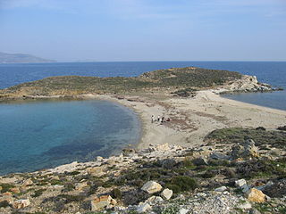
WGugh could be described as the sixth inhabited island of the Isles of Scilly, but is usually included with St Agnes with which it is joined by a sandy tombolo known as "The Bar" when exposed at low tide. The island is only about 1 km (0.62 mi) long and about 0.5 km (0.31 mi) wide, with the highest point, Kittern Hill at 34 m (112 ft). The geology consists of Hercynian granite with shallow podzolic soils on the higher ground and deeper sandy soils on the lower ground. The former Gugh farm is just north of the neck across the middle of the island between the two hills. The two houses were designed and built in the 1920s by Charles Hamlet Cooper. The name is often mispronounced as "Goo", "Guff" or even "Gogh".
 W
WGurteen Beach, located in Roundstone, County Galway, in the Connemara region of the west of Ireland, lies back-to-back with Dog's Bay. The two beaches were formed by a sand spit and tombolo which now separates the two bays known as Gurteen Bay and Dog's Bay. The name Gurteen derives from the Irish Goirtín meaning small plot or small field.
 W
WHakata Bay is a bay in the northwestern part of Fukuoka city, on the Japanese island of Kyūshū. It faces the Tsushima Strait, and features beaches and a port, though parts of the bay have been reclaimed in the expansion of the city of Fukuoka. The bay is perhaps most famous for the Mongol invasions of Japan of 1274 and 1281 which took place nearby; both invasions are sometimes referred to as the "Battle of Hakata Bay."
 W
WHowth Head is a peninsula northeast of the city of Dublin in Ireland, within the governance of Fingal County Council. Entry to the headland is at Sutton while the village of Howth and the harbour are on the north-eastern face. Most of Howth Head is occupied by the Hill of Howth, though there are other regions, such as the tombolo at Sutton, extensive beaches on the northern shores, and small ones in other parts. The Baily Lighthouse is on the southeastern part of Howth Head. Nearby are the districts of Baldoyle and Portmarnock, and adjacent is the nature reserve of North Bull Island.
 W
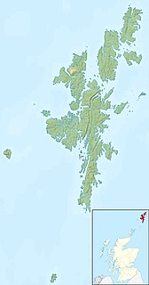
WHuney is an uninhabited island due east of the island of Unst in the Shetland Islands, Scotland. The island is located approximately 1 kilometre south west of the Balta and has an area of just under 0.2 square kilometres (0.08 sq mi). Huney is linked to Unst at an extremely low tide by a sandy tombolo called the Yei of Huney. It is uninhabited.
 W
WThe Karikari Peninsula on the east coast of the far north of Northland is between Rangaunu Harbour to the west, and Doubtless Bay to the southeast. It is a right-angled land mass of two relatively distinct parts. The rocky northern part, which has an east–west orientation and is approximately 17 km long, was originally an island but is now connected to the mainland by a low sandy tombolo approximately 11 km long, which has a north–south orientation. The spiritually significant Puwheke sits high above the north-facing beaches.
 W
WKiket Island is a small islet in Washington, co-owned by the Washington State Parks and Recreation Commission and the Swinomish Indian Tribal Community. Located at Snee Oosh, less than four miles northwest of the town of LaConner in Skagit County, Washington, Kiket is connected to Fidalgo Island by a tombolo, over which runs an access road. Thus, Kiket Island is not what most people would consider an island.
 W
WBarrenjoey is a locality in the suburb of Palm Beach, at the most northern tip of Pittwater. The headland is made up primarily of sandstones of the Newport Formation, the top third is a cap of Hawkesbury sandstone. Around 10,000 years ago the headland was cut off from the mainland due to the rising sea level; subsequent buildup of a sand spit or tombolo reconnected the island to the mainland. It is the location of the Barrenjoey Head Lighthouse, a lighthouse that was first lit in 1881. In 1995 Barrenjoey was gazetted into Ku-ring-gai Chase National Park.
 W
WLangness is a peninsula which protrudes two kilometres at the southern extremity of the Isle of Man. Signifying a cape or extended promontory, Langness literally means "long promontory" in Old Norse. Formerly an island, Langness was eventually joined to the mainland by the movement and deposition of material along Castletown Bay to form a tombolo. The small community of Derbyhaven is situated on the east coast of this isthmus, which lies close to Castletown, Isle of Man.
 W
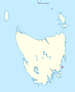
WLouisa Island is an island with a short sandy tombolo, located adjacent to the south-western coast of Tasmania, Australia. The irregularly shaped 23-hectare (0.089 sq mi) island is part of the Maatsuyker Islands Group, and comprises part of the Southwest National Park and the Tasmanian Wilderness World Heritage Site.
 W
WMa Shi Chau (Chinese: 馬屎洲; Sidney Lau: Ma5Si2Jau1, literally "Horse Dung Island") is an island of Hong Kong, under the administration of Tai Po District. It is located in Tolo Harbour in the northeast New Territories (near Sam Mun Tsai). It is connected with another island, Yim Tin Tsai, by an isthmus traversable at low tide.
 W
WMaria Island, is a mountainous island located in the Tasman Sea, off the east coast of Tasmania, Australia. The 115.5-square-kilometre (44.6 sq mi) island is contained within the Maria Island National Park, which includes a marine area of 18.78 square kilometres (7.25 sq mi) off the island's northwest coast. The island is about 20 kilometres (12 mi) in length from north to south and, at its widest, is about 13 kilometres (8.1 mi) west to east. At its closest point, Point Lesueur, the island lies approximately 4 kilometres (2.5 mi) off the east coast of Tasmania.
 W
WMonte Argentario is a comune (municipality) and a peninsula belonging to the Province of Grosseto in the Italian region Tuscany, located about 150 kilometres (93 mi) south of Florence and about 35 kilometres (22 mi) south of Grosseto. The peninsula is connected with the mainland by three spits of land which form two lagoons, the Laguna di Ponente on the west side and the Laguna di Levante on the east side of the middle dam. The two main villages on Monte Argentario are Porto Santo Stefano, chief town, facing north, and Porto Ercole facing south.
 W
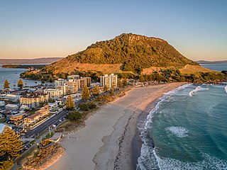
WMount Maunganui is a major residential, commercial and industrial suburb of the Tauranga metropolitan area, located on a peninsula to the north-east of Tauranga's city centre. It was an independent town from Tauranga until the completion of the Tauranga Harbour Bridge in 1988, which connects Mount Maunganui to Tauranga's central business district.
 W
WNahant is a town in Essex County, Massachusetts, United States. The population was 3,410 at the 2010 census, which makes it the smallest municipality by population in Essex County. With just 1.0 square mile (2.7 km2) of land area, it is the smallest municipality by area in the state. It is primarily a residential community. The town is situated on peninsula consisting of two near-islands connected to the mainland by a narrow sandy isthmus traversed by a single causeway known as "Nahant Road". Numerous tourist beaches line the shores, with the most popular being the so-called "Long Beach" and "Short Beach" along the eastern side of the causeway.
 W
WNorth Cape is located at the northern end of the Northland Peninsula in the North Island of New Zealand. It is the northeastern tip of the Aupouri Peninsula and lies 30 kilometres (19 mi) east and 3 kilometres (1.9 mi) north of Cape Reinga. The name North Cape is sometimes used to refer just to the cape that is known in Māori as Otou and which overlooks Murimotu Island, and sometimes just to the eastern point of Murimotu Island. It is also used to refer to the whole larger headland stretching about five km from Murimotu Island westwards to Kerr Point (Ngatuatata) and including the Surville Cliffs. This wider North Cape, and specifically the Surville Cliffs, is the northernmost point of mainland New Zealand, being about three km further north than Cape Reinga. This article covers the wider North Cape. Statistics New Zealand uses a much larger statistical area called North Cape, extending south to the Houhora Heads in the 2018 New Zealand census. That area is covered by the article on Aupouri Peninsula.
 W
WThe Otago Peninsula is a long, hilly indented finger of land that forms the easternmost part of Dunedin, New Zealand. Volcanic in origin, it forms one wall of the eroded valley that now forms Otago Harbour. The peninsula lies south-east of Otago Harbour and runs parallel to the mainland for 20 km, with a maximum width of 9 km. It is joined to the mainland at the south-west end by a narrow isthmus about 1.5 km wide.
 W
WPalisadoes is the thin tombolo of sand that serves as a natural protection for Kingston Harbour, Jamaica. Norman Manley International Airport and the historic town of Port Royal are both on Palisadoes.
 W
WPeniche is a seaside municipality and a city in Portugal. It is located in the Oeste region, formerly Estremadura Province. The population in 2011 was 27,753, in an area of 77.55 km2. The city itself has a population of about 15,600 inhabitants. The present mayor is Henrique Bertino, elected by the independent coalition GCEPP.
 W
WPeñón de Vélez de la Gomera is a Spanish exclave and rocky tied island, to the west of the Mediterranean Sea, connected to the Moroccan shore by a sandy isthmus. It is also connected to a smaller islet to the east, La Isleta, by a rocky isthmus. The tied island was named Hajar Badis and was connected to the town of Badis.
 W
WPigeon Island is a 44-acre (180,000 m2) islet located in Gros Islet in the northern region of Saint Lucia. Once isolated from the country in the Caribbean Sea, the island was artificially joined to the western coast of mainland in 1972 by a man-made causeway built from dirt excavated to form the Rodney Bay Marina. Composed of two peaks the island is a historic site with numerous forts such as an 18th-century British fort and Fort Rodney both used by the British to spy on French Ships from neighbouring Martinique. In 1979 it was named a national park and again in 1992 it became a national landmark under the control of the Saint Lucia National Trust (SLNT). Today, Pigeon Island is the home and major venue of the Saint Lucia Jazz Festival.
 W
WThe Point Stephens Light is a heritage-listed active lighthouse located on Point Stephens, a point on an unnamed headland at the east of Fingal Bay, 4.25 km (2.64 mi) south of the entrance of Port Stephens, New South Wales, Australia. The light serves to assist vessels entering Port Stephens. It is considered an endangered lighthouse due to remote location and old age.
 W
WThe Isle of Portland is a tied island, 6 kilometres (4 mi) long by 2.7 kilometres (1.7 mi) wide, in the English Channel. Portland is 8 kilometres (5 mi) south of the resort of Weymouth, forming the southernmost point of the county of Dorset, England. A barrier beach called Chesil Beach joins it to the mainland. The A354 road passes down the Portland end of the beach and then over the Fleet Lagoon by bridge to the mainland. The population of Portland is 12,797.
 W
WPresqu'ile Provincial Park is a park in southeastern Northumberland County on the north shore of Lake Ontario near the town of Brighton in Ontario, Canada. The park occupies an area of 9.37 km2 (3.62 sq mi). The name of the park is the French word for peninsula, or literally "almost island", and was believed to be named by Samuel De Champlain on his second expedition. The peninsula was formed when a limestone island was connected to the mainland by a sand spit; this kind of formation is referred to as a tombolo.
 W
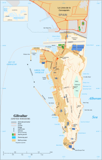
WThe Rock of Gibraltar, also known as the Jabel-al-Tariq, is a monolithic limestone promontory located in the territory of Gibraltar, near the southwestern tip of Europe on the Iberian Peninsula. It is 426 m (1,398 ft) high. Most of the Rock's upper area is covered by a nature reserve, which is home to around 300 Barbary macaques. These macaques, as well as a labyrinthine network of tunnels, attract many tourists each year.
 W
WSaint Mark is one of Dominica's ten administrative parishes. It is bordered by St. Luke and St. Patrick. With an area of 9.9 km² (2 mi²), it is the smallest in the island. It had a population of 1,834 people at the Population Census of 2011.
WSamphrey is an uninhabited island in the Shetland Islands, Scotland. One of Fair Isle's old names is "Friðarey" which is of similar origin.
 W
WSharp Island or Kiu Tsui Chau is the largest island in the Kiu Tsui Country Park located at Port Shelter of Sai Kung, Hong Kong. The area is most known for fishing, swimming as well as diving. Sharp Island is under the administration of Sai Kung District.
 W
WSplit Rock Lighthouse State Park is a state park of Minnesota on the North Shore of Lake Superior. It is best known for the picturesque Split Rock Lighthouse, one of the most photographed lighthouses in the United States. Built by the United States Lighthouse Service in 1910, the lighthouse and some adjacent buildings have been restored and the Minnesota Historical Society operates them as a museum. The 2,200-acre (890 ha) state park offers a unique cart-in campground and scenic trails for hiking, cross-country skiing, and bicycling.
 W
WSt Ninian's Isle is a small tied island connected by the largest tombolo in the UK to the south-western coast of the Mainland, Shetland, in Scotland. It is part of the civil parish of Dunrossness on the South Mainland. The tombolo, known locally as an ayre from the Old Norse for "gravel bank", is 500 metres long. During the summer the tombolo is above sea level and accessible to walkers. During winter, stronger wave action removes sand from the beach so that it is usually covered at high tide, and occasionally throughout the tidal cycle, until the sand is returned the following spring. Depending on the definition used, St. Ninian's is thus either an island, or a peninsula; it has an area of about 72 hectares.
WWest Burra is one of the Scalloway Islands, a subgroup of the Shetland Islands in Scotland. It is connected by bridge to East Burra. With an area of 743 hectares (2.87 sq mi), it is the eleventh largest of the Shetland Islands.