 W
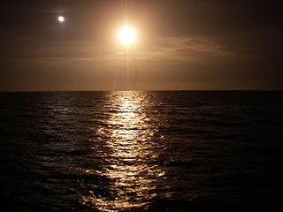
WThe Indian River is a 121-mile (195 km) long brackish lagoon in Florida. It is part of the Indian River Lagoon system, which in turn forms part of the Atlantic Intracoastal Waterway. It was originally named Rio de Ais after the Ais Indian tribe, who lived along the east coast of Florida, but was later given its current name.
 W
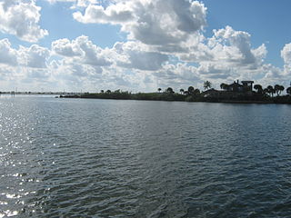
WThe Indian River Lagoon is a grouping of three lagoons: the Mosquito Lagoon, the Banana River, and the Indian River, on the Atlantic Coast of Florida; one of the most biodiverse estuaries in the Northern Hemisphere and is home to more than 4,300 species of plants and animals.
 W
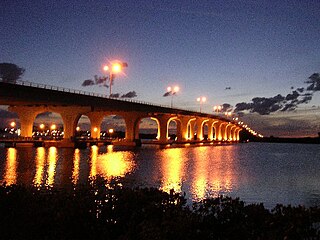
WThe 17th Street Bridge is a fixed concrete bridge that spans the Indian River intracoastal waterway in Indian River County, Florida. The bridge, started in 1977, was constructed by Gulf Contracting Inc, FL and was completed in 1979.
 W
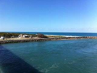
WThe Archie Carr National Wildlife Refuge is part of the United States National Wildlife Refuge (NWR) System, located along a twenty-mile (30 km) section of coastline from Melbourne Beach to Wabasso Beach, Florida along State Road A1A. The 900 acre (3.6 km2) refuge was established in 1991, to protect the loggerhead and green sea turtles.
 W
WBallard Park is a public park located at 924 Thomas Barbour Drive, Melbourne, Florida and is situated on the Indian River Lagoon and the Eau Gallie River. It contains diverse recreational facilities and amenities, including boat ramps, lighted tennis courts and a pavilion. The park also contains a memorial to naturalist and author Thomas Barbour, who frequented the shell mounds on the park grounds as a boy.
 W
WThe Banana River is a 31-mile-long (50 km) lagoon that lies between Cape Canaveral and Merritt Island in Brevard County, Florida in the United States. It is part of the Indian River Lagoon system, and connects at its south end to the Indian River; it is the only part of the lagoon system not in the Intracoastal Waterway. It also has an outlet to the Atlantic Ocean via a lock into Port Canaveral. The lagoon includes salt marshes, mangrove swamps, seagrass beds, drift algae, oyster bars, tidal flats, and spoil islands, providing habitats for many marine species. These are brackish waters mixed of salt and fresh water; waist deep with a soft bottom sand/grass. Commercial and recreational activities in the lagoon generate more than US$ 800 million annually for the local economy.
 W
WThe Canaveral Barge Canal provides an east-to-west link between the Atlantic Ocean and Indian River Lagoon across northern Merritt Island, Florida, in two segments separated by the Banana River. It is located 15 miles south of Titusville, Florida. The canal is 12 feet deep and has entrances to other water systems including Syke's Creek and various marinas. The canal links Port Canaveral along the Atlantic Ocean to the Intracoastal Waterway running down the center of the Indian River Lagoon. The canal was constructed to allow the transport of crude oil by barge to the two power plants south of Titusville, Florida.
 W
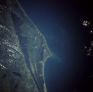
WCape Canaveral is a prominent cape in Brevard County, Florida, in the United States, near the center of the state's Atlantic coast. Officially Cape Kennedy from 1963 to 1973, it lies east of Merritt Island, separated from it by the Banana River.
 W
WThe Eau Gallie Causeway connects Eau Gallie, Florida, with SR A1A near Indian Harbour Beach, across the Indian River Lagoon. Located entirely within the Melbourne city limits, the causeway consists of a main bridge crossing over the Intracoastal Waterway and a relief bridge. The bridge is a key link in SR 518, Eau Gallie Boulevard, of which the causeway is a part.
 W
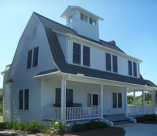
WThe Eau Gallie Yacht Club is a U.S. boating organization, located in Indian Harbour Beach, Florida with access to the Indian River. The original clubhouse is also a historic building. The club has 1,200 members.
 W
WFort Pierce Inlet State Park, a 340-acre (1.4 km2) part of the Florida State Park system, is located just north of the Fort Pierce Inlet, on North Hutchinson Island, near Fort Pierce. It consists of beaches, dunes and a coastal hammock between the Atlantic Ocean and the waters of Tucker Cove, an indentation of the Indian River Lagoon.
 W
WThe Haulover Canal is a waterway north of Merritt Island, Florida, near the former site of Allenhurst, that connects Mosquito Lagoon with the Indian River, and is part of the Intracoastal Waterway.
 W
WKnown for beautiful beaches, nature preserves and parks, Hutchinson Island consists of two barrier islands on the coast of Martin, St. Lucie, and Indian River counties, Florida. The two islands are separated by the Fort Pierce Inlet and are known as North Hutchinson Island and South Hutchinson Island. North Hutchinson Island is divided into two counties - Indian River County and St. Lucie County. The Indian River county portion of North Hutchinson Island which extends to the Sebastian Inlet is sometimes called Orchid Island, although it is not a separate island. See the Wikipage for North Hutchinson Island for more information.
 W
WThe Jaega were Native Americans living in a chiefdom of the same name, which included the coastal parts of present-day Martin County and Palm Beach County, Florida at the time of initial European contact, and until the 18th century. The area occupied by the Jaega corresponds to the East Okeechobee Area, an archaeological culture that is part of, or closely related to, the Belle Glade culture. The name Jobé, or Jové [ˈxoβe], has been identified as a synonym of Jaega, a sub-group of the Jaega, or a town of the Jaega.
WThe Jaega were Native Americans living in a chiefdom of the same name, which included the coastal parts of present-day Martin County and Palm Beach County, Florida at the time of initial European contact, and until the 18th century. The area occupied by the Jaega corresponds to the East Okeechobee Area, an archaeological culture that is part of, or closely related to, the Belle Glade culture. The name Jobé, or Jové [ˈxoβe], has been identified as a synonym of Jaega, a sub-group of the Jaega, or a town of the Jaega.
 W
WJupiter Island is a barrier island on the coast of Martin and Palm Beach counties, Florida. It is bounded on the east by the Atlantic Ocean, on the north by the St. Lucie Inlet, on the west by the Indian River, and on the south by the Jupiter Inlet. Jupiter Island originally was two islands, Long Island on the north and Jupiter Island on the south, which were once separated by an inlet in the vicinity of North Jupiter Narrows and what is officially called Peck Lake, but commonly called Peck's Lake.
 W
WMathers Bridge is a 700-foot-long (210 m) low-level swing bridge located on the southern tip of Merritt Island, Florida, crossing the Banana River at the end of County Road 3.
 W
WThe Melbourne Beach Pier is a historic pier in Melbourne Beach, Florida, United States. It is located at Ocean Avenue and Riverside Drive and the pier extends onto the Indian River. The Melbourne and Atlantic Railroad Company built the pier in 1889. On April 12, 1984, it was added to the U.S. National Register of Historic Places.
 W
WThe Melbourne Causeway is located entirely within Brevard County, Florida in the United States. It is composed of three bridges and connects the municipalities of Melbourne and Indialantic across the Indian River Lagoon in Brevard County. The causeway is part of U.S. 192, whose eastern terminus is located approximately 2 miles (3.2 km) east of the bridge, at SR A1A. East of the bridge, the road is known locally as Fifth Avenue. On the western side, the road continues through downtown Melbourne as Strawbridge Avenue. Each July 4 the bridge is closed for a fireworks show.
 W
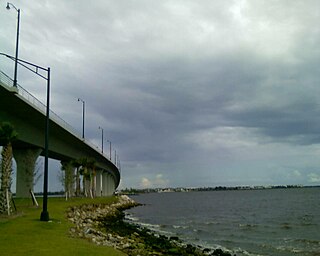
WThe Merrill P. Barber Bridge is a concrete arch bridge that spans the Indian River Intracoastal Waterway in Indian River County, Florida. The bridge was built by Odebrecht Contractors of Florida, Inc. and was completed in 1995. A fishing pier is constructed below the bridge on the east side.
 W
WThe Merritt Island Causeway, mostly in Merritt Island, connects Cocoa, Merritt Island, Florida, and Cocoa Beach, Florida. The causeway transits the Willard Peebles bridge over the Banana River Lagoon. In the 1960s, SR A1A was routed over the eastern causeway from present day SR 520 and SR A1A, to the present day intersection of SR 520 and SR 3 on Merritt Island. The eastern section is known as the Cocoa Beach Causeway.
 W
WThe Merritt Island Dragon or Merrit Island River Dragon was a dragon-shaped green concrete structure that stood at the southern tip of Merritt Island, known as Dragon Point, where the Indian River Lagoon splits to form the Banana River Lagoon. The dragon was built in 1971 by Florida artist Lewis VanDercar and property owner Aynn Christal. In 1981, the statue was expanded for new property owner Warren McFadden, with the addition of a tail, an extended neck, two cavepeople a caveman named Fred and a cavewoman named Wilma and four hatchling dragons named Joy, Sunshine, Charity, and Freedom. The statues were located in the city of Melbourne, Florida, north of the Eau Gallie Causeway.
 W
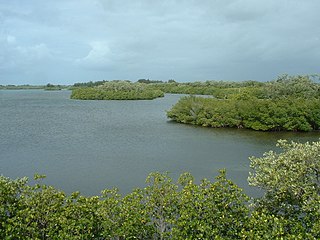
WMosquito Lagoon is a body of water located on the east coast of Florida in Brevard and Volusia counties. It is part of the Indian River Lagoon system and the Atlantic Intracoastal Waterway. It extends from the Ponce de Leon Inlet to a point north of Cape Canaveral, and connects to the Indian River via the Haulover Canal. The Mosquito Lagoon Aquatic Preserve includes 4,740 acres (1,920 ha) in the northern end of the lagoon. The preserve originally extended to the southern end of the lagoon, but close to two-thirds of the preserve in the central and southern lagoon were transferred to the Federal government, and is now part of the Canaveral National Seashore. The cities of New Smyrna Beach and Edgewater, the Merritt Island National Wildlife Refuge and the Kennedy Space Center adjoin the lagoon.
 W
WThe Moulton–Wells House is a historic house in New Smyrna Beach, Florida. It is located west of Eldora Road, and is part of the Canaveral National Seashore. On November 21, 2001, it was added to the U.S. National Register of Historic Places.
 W
WNASA Parkway, also known as NASA Causeway, is an east-west expressway in Brevard County, Florida, containing two causeways. The first causeway connects the Florida mainland to Merritt Island and later, over the private second causeway, connects Merritt Island to Cape Canaveral. As such, the NASA Parkway is the main route connecting points of interest in Titusville, Florida to the Kennedy Space Center on Merritt Island.
 W
WNorth Hutchinson Island is an Atlantic coastal barrier island on the east coast of Florida in the United States. The island is known for clean expansive beaches, wildlife preserves, parks, shops and restaurants.
 W
WThe Okeechobee Waterway or Okeechobee Canal is a relatively shallow man-made waterway in the United States, stretching across Florida from Fort Myers on the west coast to Stuart on Florida's east coast. The waterway can support tows such as barges or private vessels up to 50 feet wide x 250 feet long which draw less than 10 feet, as parts of the system, especially the locks may have low water depths of just ten feet. The system of channels runs through Lake Okeechobee and consists of the Caloosahatchee River to the west of the lake and the St. Lucie Canal (C-44) east of the lake.
WThe Okeechobee Waterway or Okeechobee Canal is a relatively shallow man-made waterway in the United States, stretching across Florida from Fort Myers on the west coast to Stuart on Florida's east coast. The waterway can support tows such as barges or private vessels up to 50 feet wide x 250 feet long which draw less than 10 feet, as parts of the system, especially the locks may have low water depths of just ten feet. The system of channels runs through Lake Okeechobee and consists of the Caloosahatchee River to the west of the lake and the St. Lucie Canal (C-44) east of the lake.
 W
WOrchid Island sometimes known as North Hutchinson Island is an Atlantic coastal barrier island in Indian River County, Florida, United States. North Hutchinson island is separated from the mainland on the west by the Indian River Lagoon. North Hutchinson Island is known for its beaches, restaurants, shops, wildlife preserves and parks. See the North Hutchinson Island wiki for additional information.
 W
WPalm Bay is a bay located in Palm Bay, Florida, United States and is bordered to the south by the Palm Bay Pointe peninsula. It is an estuary of Indian River, and Turkey Creek drains into Palm Bay. Pioneers initially settled in Palm Bay as they moved into the area in the late 19th century. The city of Palm Bay received its name from this bay.
 W
WPelican Island National Wildlife Refuge is a United States National Wildlife Refuge (NWR), and part of the Everglades Headwaters NWR complex, located just off the western coast of Orchid Island in the Indian River Lagoon east of Sebastian, Florida. The refuge consists of a 3-acre (12,000 m2) island that includes an additional 2.5 acres (10,000 m2) of surrounding water and is located off the east coast of Florida of the Indian River Lagoon. Established by an executive order of President Theodore Roosevelt on March 14, 1903, Pelican Island was the first National wildlife refuge in the United States. It was created to protect egrets and other birds from extinction through plume hunting.
 W
WThe Ponce de Leon Inlet is a natural opening in the barrier islands in central Florida that connects the north end of the Mosquito Lagoon and the south end of the Halifax River to the Atlantic Ocean. The inlet originally was named Mosquito Inlet. In 1926 the Florida Legislature changed the name from Mosquito Inlet to Ponce de Leon Inlet. There was precedent for the change. Mosquito County had long before become Orange County, and the Mosquito River had become the Halifax River. Only the Mosquito Lagoon has kept its old name. It is the site of the town of Ponce Inlet, Florida and the Ponce de Leon Inlet Light. The inlet is maintained by the Ponce de Leon Inlet & Port District, a Division of the Volusia County, Florida government.
 W
WPonce de León Island was a proposed name for the 45 miles (72 km) long, barrier island stretching from Cape Canaveral to Sebastian Inlet in Brevard County in central Florida, located on the Atlantic Ocean. The population was 67,933 at the 2010 United States Census. The barrier island is 21.4 square miles (55 km2). Another proposed name for this area was Ais Island after the native Ais people who originally inhabited the area. Currently, the island has not yet been designated any official name.
 W
WThe Treasure Coast is a region of the U.S. state of Florida. It is located on the state's Atlantic coast, comprising Indian River, St. Lucie, and Martin counties. The region, whose name refers to the Spanish Treasure Fleet lost in a 1715 hurricane, evidently emerged from residents' desire to distinguish themselves from Miami and the Gold Coast region to the south.
WThe Treasure Coast is a region of the U.S. state of Florida. It is located on the state's Atlantic coast, comprising Indian River, St. Lucie, and Martin counties. The region, whose name refers to the Spanish Treasure Fleet lost in a 1715 hurricane, evidently emerged from residents' desire to distinguish themselves from Miami and the Gold Coast region to the south.
 W
WThe St. Lucie Inlet, Florida is located between Hutchinson Island and Jupiter Island in Martin County, Florida, at coordinates 27°09′58″N 80°09′24″W. The St. Lucie Inlet is one of six inlets into the Indian River Lagoon.
 W
WSebastian Inlet, located in Sebastian Inlet State Park in Brevard County, Florida and Indian River County, Florida, offers surfing and fishing opportunities. It is off State Road A1A just 12 miles north of Vero Beach. There are annual surf tournaments, professional and amateur. Visitors fish there, particularly for Snook and Redfish.
WSebastian Inlet State Park is a Florida state park located 10 miles south of Melbourne Beach and 6 miles north of Vero Beach in Florida. The park lies on both sides of the Sebastian Inlet, which forms the boundary between Brevard and Indian River counties. The land for the park was acquired by the state of Florida in 1971. In 2010, it was the second most visited state park in Florida.
 W
WSeminole Rest is a historic site in Oak Hill, Florida, United States. It is located east of State Road 5, on the western shore of Mosquito Lagoon, and is part of the Canaveral National Seashore. On March 19, 1997, it was added to the U.S. National Register of Historic Places.
WSewall's Point is a town located on the peninsula of the same name in Martin County, Florida, United States. The population was 1,996 at the 2010 census. As of 2018, the population recorded by the U.S. Census Bureau was 2,216. Both the town and the peninsula are named for Capt. Henry Edwin Sewall. It is an eastern suburb of the county seat of Stuart.
WThe Treasure Coast is a region of the U.S. state of Florida. It is located on the state's Atlantic coast, comprising Indian River, St. Lucie, and Martin counties. The region, whose name refers to the Spanish Treasure Fleet lost in a 1715 hurricane, evidently emerged from residents' desire to distinguish themselves from Miami and the Gold Coast region to the south.
 W
WThe Wabasso Causeway Bridge is a two-lane concrete bridge spanning the Indian River in Indian River County, Florida. The bridge was built by Scott Construction Company and was completed in 1970.