 W
WThe Great Basin is the largest region of contiguous endorheic drainage basins in North America, and is encompassed by the Great Basin Divide. This is a list of the drainage basins in the Great Basin that are over 500 sq mi (1,300 km2), listed by the state containing most of the basin.
 W
WThe ACF River Basin is the drainage basin, or watershed, of the Apalachicola River, Chattahoochee River, and Flint River, in the Southeastern United States.
 W
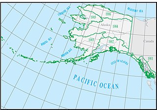
WThe Alaska water resource region is one of 21 major geographic areas, or regions, in the first level of classification used by the United States Geological Survey to divide and sub-divide the United States into successively smaller hydrologic units. These geographic areas contain either the drainage area of a major river, or the combined drainage areas of a series of rivers.
 W
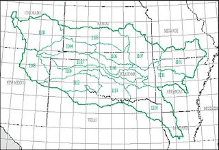
WThe Arkansas–White–Red water resource region is one of 21 major geographic areas, or regions, in the first level of classification used by the United States Geological Survey to divide and sub-divide the United States into successively smaller hydrologic units. These geographic areas contain either the drainage area of a major river, or the combined drainage areas of a series of rivers.
 W
WThe Blind Brook watershed is a significant, natural drainage basin and environmental resource located in Westchester County, New York. It occupies approximately 10.91 square miles or 6,980 acres falling largely within the Town of Rye. It spans the borders of New York and Connecticut.
 W
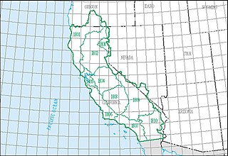
WThe California water resource region is one of 21 major geographic areas, or regions, in the first level of classification used by the United States Geological Survey to divide and sub-divide the United States into successively smaller hydrologic units. These geographic areas contain either the drainage area of a major river, or the combined drainage areas of a series of rivers.
 W
W W
WThe Carson Desert is a desert in the Lahontan Basin and the desert valley of Churchill County, Nevada (U.S.), which receives an average 5 inches (130 mm) annual precipitation. The desert is the low valley area between the adjacent mountain ranges, while the larger watershed includes the interior slopes of the demarcating ranges. The desert was inundated by Lake Lahontan during the Pleistocene, and the watershed became part of Nevada's Conservation Security Program in 2005.
 W
WThe Columbia River drainage basin is the drainage basin of the Columbia River in the Pacific Northwest region of North America. It covers 668,000 km2 or 258,000 sq mi. In common usage, the term often refers to a smaller area, generally the portion of the drainage basin that lies within eastern Washington.
 W
WThis page is about the Croton River watershed, a hydrological feature. For the component of the New York City water supply system with a similar name, see Croton Watershed
WThis page is about a component of the New York City water supply system. For the hydrological feature with a similar name, see Croton River watershed
 W
WThe Fourche Creek watershed is arguably the most important urban watershed in the state of Arkansas in the United States for ecological, economic, and social reasons.
 W
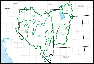
WThe Great Basin water resource region is one of 21 major geographic areas, or regions, in the first level of classification used by the United States Geological Survey to divide and sub-divide the United States into successively smaller hydrologic units. These geographic areas contain either the drainage area of a major river, or the combined drainage areas of a series of rivers.
 W
WThe Great Lakes Basin consists of the Great Lakes and the surrounding lands of the states of Illinois, Indiana, Michigan, Minnesota, New York, Ohio, Pennsylvania, and Wisconsin in the United States, and the province of Ontario in Canada, whose direct surface runoff and watersheds form a large drainage basin that feeds into the lakes. It is generally considered to also include a small area around and beyond Wolfe Island, Ontario, at the east end of Lake Ontario, which does not directly drain into the Great Lakes, but into the Saint Lawrence River.
 W
WThe Great Lakes water resource region is one of 21 major geographic areas, or regions, in the first level of classification used by the United States Geological Survey to divide and sub-divide the United States into successively smaller hydrologic units. These geographic areas contain either the drainage area of a major river, or the combined drainage areas of a series of rivers.
 W
WThe Hawaii water resource region is one of 21 major geographic areas, or regions, in the first level of classification used by the United States Geological Survey to divide and sub-divide the United States into successively smaller hydrologic units. These geographic areas contain either the drainage area of a major river, or the combined drainage areas of a series of rivers.
 W
WThe Honey Hollow Watershed is a 650-acre (2.6 km2) watershed on the south side of the Delaware River a few miles north of New Hope, Pennsylvania. It is the site of the first privately owned soil conservation district in the United States. Created by five landowners in 1933, it was successful in mitigating the effects of erosion caused by the introduction of modern agricultural methods in the early 20th century. The area was designated a National Historic Landmark District in 1969.
 W
WThe Klamath Basin is the region in the U.S. states of Oregon and California drained by the Klamath River. It contains most of Klamath County and parts of Lake and Jackson counties in Oregon, and parts of Del Norte, Humboldt, Modoc, Siskiyou, and Trinity counties in California. The 15,751-square-mile (40,790 km2) drainage basin is 35% in Oregon and 65% in California. In Oregon, the watershed typically lies east of the Cascade Range, while California contains most of the river's segment that passes through the mountains. In the Oregon-far northern California segment of the river, the watershed is semi-desert at lower elevations and dry alpine in the upper elevations. In the western part of the basin, in California, however, the climate is more of temperate rainforest, and the Trinity River watershed consists of a more typical alpine climate.
 W
WLake Erie Basin consists of Lake Erie and surrounding watersheds, which are typically named after the river, creek, or stream that provides drainage into the lake. The watersheds are located in the states of Indiana, Michigan, New York, Ohio, and Pennsylvania in the United States, and in the province of Ontario in Canada. The basin is part of the Great Lakes Basin and Saint Lawrence River Watershed, which feeds into the Atlantic Ocean. 80% of the lake's water flows in from the Detroit River, with only 9% coming from all of the remaining watersheds combined. A littoral zone serves as the interface between land and lake, being that portion of the basin where the lake is less than 15 feet (4.6 m) in depth.
 W
WThe U.S. state of Colorado includes the headwaters of several important rivers. The state is divided into two major hydrographic regions by the Continental Divide of the Americas. East of the Continental Divide, surface waters flow to the Gulf of Mexico, either via the Rio Grande or via one of several rivers which eventually feed the Mississippi River along the way. West of the Continental Divide, surface waters flow via the Green River, the upper Colorado River, or the San Juan River into the Colorado River and on to the Gulf of California. Colorado also has three significant endorheic basins: the San Luis Closed Basin in the San Luis Valley, and the Bear Creek Basin and the White Woman Basin spanning the Colorado-Kansas border north and south of the Arkansas River.
 W
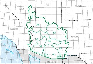
WThe Lower Colorado water resource region is one of 21 major geographic areas, or regions, in the first level of classification used by the United States Geological Survey to divide and sub-divide the United States into successively smaller hydrologic units. These geographic areas contain either the drainage area of a major river, or the combined drainage areas of a series of rivers.
 W
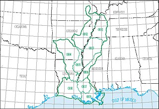
WThe Lower Mississippi water resource region is one of 21 major geographic areas, or regions, in the first level of classification used by the United States Geological Survey to divide and sub-divide the United States into successively smaller hydrologic units. These geographic areas contain either the drainage area of a major river, or the combined drainage areas of a series of rivers.
 W
WThe Merrimack River is a 117-mile-long (188 km) river in the northeastern United States. It rises at the confluence of the Pemigewasset and Winnipesaukee rivers in Franklin, New Hampshire, flows southward into Massachusetts, and then flows northeast until it empties into the Gulf of Maine at Newburyport. From Pawtucket Falls in Lowell, Massachusetts, onward, the Massachusetts–New Hampshire border is roughly calculated as the line three miles north of the river.
 W
WThe Mid Atlantic water resource region is one of 21 major geographic areas, or regions, in the first level of classification used by the United States Geological Survey to divide and sub-divide the United States into successively smaller hydrologic units. These geographic areas contain either the drainage area of a major river, or the combined drainage areas of a series of rivers.
The Minnehaha Creek Watershed District's mission is to collaborate with public and private partners to protect and improve land and water for current and future generations. The Minnehaha Creek in its name refers to the water link from Lake Minnetonka to the Mississippi River. The watershed is much bigger than that lake or creek, and includes 29 communities, and encompasses 178 square miles (460 km2). It stretches West from about Minnehaha Falls to Saint Bonifacius and North to Maple Plain. It includes 129 lakes and 8 major creeks in Hennepin and Carver counties. Some of the lakes in the district are: Bde Maka Ska, Harriet, Nokomis, Parley, Minnewashta and Katrina.
 W
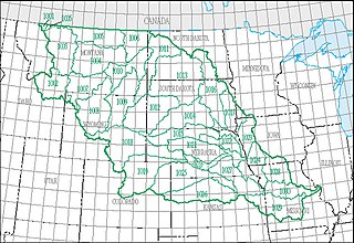
WThe Missouri water resource region is one of 21 major geographic areas, or regions, in the first level of classification used by the United States Geological Survey to divide and sub-divide the United States into successively smaller hydrologic units. These geographic areas contain either the drainage area of a major river, or the combined drainage areas of a series of rivers.
 W
WThe Nemaha River basin includes the areas of the U.S. state of Nebraska below the Platte River basin that drain directly into the Missouri River. The major streams of the drainage include Weeping Water Creek, Muddy Creek, Little Nemaha River, and Big Nemaha River. The basin has a total area of approximately 2,800 square miles (7,300 km2), and includes much of southeastern Nebraska.
 W
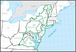
WThe New England water resource region is one of 21 major geographic areas, or regions, in the first level of classification used by the United States Geological Survey to divide and sub-divide the United States into successively smaller hydrologic units. These geographic areas contain either the drainage area of a major river, or the combined drainage areas of a series of rivers. The New England region, which is listed with a 2-digit hydrologic unit code (HUC) of 01, has an approximate size of 73,753 square miles, and consists of 11 sub-regions, which are listed with the 4-digit HUCs 0101 through 0111.
 W
WThe Ohio water resource region is one of 21 major geographic areas, or regions, in the first level of classification used by the United States Geological Survey to divide and sub-divide the United States into successively smaller hydrologic units. These geographic areas contain either the drainage area of a major river, or the combined drainage areas of a series of rivers.
 W
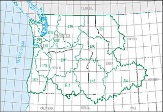
WThe Pacific Northwest water resource region is one of 21 major geographic areas, or regions, in the first level of classification used by the United States Geological Survey to divide and sub-divide the United States into successively smaller hydrologic units. These geographic areas contain either the drainage area of a major river, or the combined drainage areas of a series of rivers.
 W
WThe Rio Grande water resource region is one of 21 major geographic areas, or regions, in the first level of classification used by the United States Geological Survey to divide and sub-divide the United States into successively smaller hydrologic units. These geographic areas contain either the drainage area of a major river, or the combined drainage areas of a series of rivers.
 W
WThe Souris–Red–Rainy region is one of 21 major geographic areas, or regions, in the first level of classification used by the United States Geological Survey to divide and sub-divide the United States into successively smaller hydrologic units. These geographic areas contain either the drainage area of a major river, or the combined drainage areas of a series of rivers.
 W
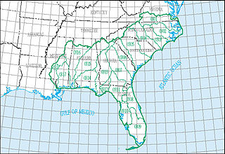
WThe South Atlantic–Gulf water resource region is one of 21 major geographic areas, or regions, in the first level of classification used by the United States Geological Survey to divide and sub-divide the United States into successively smaller hydrologic units. These geographic areas contain either the drainage area of a major river, or the combined drainage areas of a series of rivers.
 W
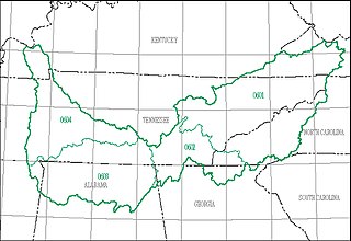
WThe Tennessee water resource region is one of 21 major geographic areas, or regions, in the first level of classification used by the United States Geological Survey to divide and sub-divide the United States into successively smaller hydrologic units. These geographic areas contain either the drainage area of a major river, or the combined drainage areas of a series of rivers.
 W
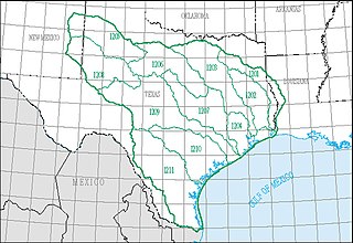
WThe Texas–Gulf water resource region is one of 21 major geographic areas, or regions, in the first level of classification used by the United States Geological Survey to divide and sub-divide the United States into successively smaller hydrologic units. These geographic areas contain either the drainage area of a major river, or the combined drainage areas of a series of rivers.
 W
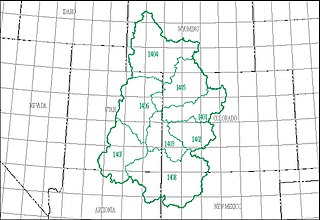
WThe Upper Colorado water resource region is one of 21 major geographic areas, or regions, in the first level of classification used by the United States Geological Survey to divide and sub-divide the United States into successively smaller hydrologic units. These geographic areas contain either the drainage area of a major river, or the combined drainage areas of a series of rivers.
 W
WThe Upper Mississippi water resource region is one of 21 major geographic areas, or regions, in the first level of classification used by the United States Geological Survey to divide and sub-divide the United States into successively smaller hydrologic units. These geographic areas contain either the drainage area of a major river, or the combined drainage areas of a series of rivers.
 W
WA water resource region is the first level of classification used by the United States Geological Survey to divide and sub-divide the United States into successively smaller hydrologic units.
 W
WThe United States Watershed Protection and Flood Prevention Act of 1954 is a United States statute. It has been amended several times.
 W
WThe Yadkin–Pee Dee River Basin is a large river basin in the eastern United States, covering around 7,221 square miles, making it the second largest in the state of North Carolina. Its headwaters rise near Blowing Rock, North Carolina, and the basin drains to the Atlantic Ocean in Winyah Bay, east of Georgetown, South Carolina.