 W
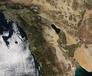
WMost of central and northern California rests on a crustal block (terrane) that is being torn from the North American continent by the passing Pacific plate of oceanic crust. Southern California lies at the southern end of this block, where the Southern California faults create a complex and even chaotic landscape of seismic activity.
 W
WThe Battle Creek Fault Zone is a system of closely parallel faults that run between the Coast Ranges near the town of Cottonwood to the west, extending northeast about 22 miles toward the southern slopes of Mt. Lassen. The faulting action is normal with terrain to the south lower than terrain to the north. Although there have been no earthquakes in historic times, it is believed that the fault zone may still be active, and has been determined to be the closest active and possibly hazardous fault to the Shasta Dam.
 W
WThe Brawley Seismic Zone (BSZ), also known as the Brawley fault zone, is a predominantly extensional tectonic zone that connects the southern terminus of the San Andreas Fault with the Imperial Fault in Southern California. The BSZ is named for the nearby town of Brawley in Imperial County, California, and the seismicity there is characterized by earthquake swarms.
 W
WThe Calaveras Fault is a major branch of the San Andreas Fault System that is located in northern California in the San Francisco Bay Area. Activity on the different segments of the fault includes moderate and large earthquakes as well as aseismic creep. The last large event was the 1984 Morgan Hill event and the last moderate earthquake was the 2007 Alum Rock event.
 W
WThe Concord Fault is a geologic fault in the San Francisco Bay Area. It is so called because it is located under the city of Concord. It is connected to, and considered to be part of, the same fault zone as the Green Valley fault, which lies just a few miles to the north across the Suisun Bay. The fault is situated at the east of West Napa Fault and extends from Mount Diablo to the Carquinez Strait, an approximately 11 mile long distance. Like most other faults in this area, the Concord Fault is a strike-slip fault, moving approximately 2.7 to 3.6 millimeters a year.
 W
WThe Walker Lane is a geologic trough roughly aligned with the California/Nevada border southward to where Death Valley intersects the Garlock Fault, a major left lateral, or sinistral, strike-slip fault. The north-northwest end of the Walker Lane is between Pyramid Lake in Nevada and California's Lassen Peak where the Honey Lake Fault Zone, the Warm Springs Valley Fault, and the Pyramid Lake Fault Zone meet the transverse tectonic zone forming the southern boundary of the Modoc Plateau and Columbia Plateau provinces. The Walker Lane takes up 15 to 25 percent of the boundary motion between the Pacific Plate and the North American Plate, the other 75 percent being taken up by the San Andreas Fault system to the west. The Walker Lane may represent an incipient major transform fault zone which could replace the San Andreas as the plate boundary in the future.
 W
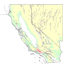
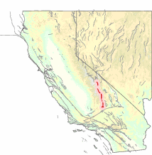
WEdna Fault is a 584-foot (178m) strike-slip fault in Edna Valley, California, known for its abrupt right angle shape when viewed from the north or south. Its cliff face faces east.
 W
WThe Elsinore Fault Zone is a large right-lateral strike-slip geological fault structure in Southern California. The fault is part of the trilateral split of the San Andreas fault system and is one of the largest, though quietest faults in Southern California.
 W
WThe Furnace Creek Fault Zone (FCFZ) is a geological fault that is located in Eastern California and southwestern Nevada. The right lateral-moving (dextral) fault extends for some 200 km (120 mi) between a connection with the Death Valley Fault Zone in the Amargosa Valley and northward to a termination in the Fish Lake Valley of southwest Nevada. The northern segment of the FCFZ is also referred to as the Fish Lake Valley Fault Zone. The FCFZ is considered an integral part of the Walker Lane.
 W
WThe Garlock Fault is a left-lateral strike-slip fault running northeast–southwest along the north margins of the Mojave Desert of Southern California, for much of its length along the southern base of the Tehachapi Mountains.
WThe Concord Fault is a geologic fault in the San Francisco Bay Area. It is so called because it is located under the city of Concord. It is connected to, and considered to be part of, the same fault zone as the Green Valley fault, which lies just a few miles to the north across the Suisun Bay. The fault is situated at the east of West Napa Fault and extends from Mount Diablo to the Carquinez Strait, an approximately 11 mile long distance. Like most other faults in this area, the Concord Fault is a strike-slip fault, moving approximately 2.7 to 3.6 millimeters a year.
 W
WThe Hayward Fault Zone is a geologic fault zone capable of generating destructive earthquakes. This fault is about 74 mi (119 km) long, situated mainly along the western base of the hills on the east side of San Francisco Bay. It runs through densely populated areas, including Richmond, El Cerrito, Berkeley, Oakland, San Leandro, Castro Valley, Hayward, Union City, Fremont, and San Jose.
WThe Healdsburg Fault is a seismically active geological feature associated with the Santa Rosa Plain and the Alexander Valley, in Sonoma County, California, United States. The eastern sides of these floodplains are bounded by strike-slip or transform faults. The maximum credible earthquake expected to be generated from the Healdsburg Fault is estimated to be about 7.5 on the Richter magnitude scale.
 W
WThe Hollywood fault is an active fault of approximately 9 miles (14 km) in length located along the northern edge of the Los Angeles basin. It is part of a system of seismically active folds and faults that constitute the complex transition zone between the Transverse and Peninsular Ranges. The Malibu Coast—Santa Monica—Hollywood fault system is the result of transtension and transpression associated with rotation of the Transverse Ranges in the Cenozoic Era. It has an established dip angle of between 70° and 90° based on surface and subsurface observations, and has experienced significant left-slip movement since the late Miocene. Its minimum and maximum dip-slip displacement rates are estimated at 0.3 mm and 0.5 mm per year, with a strike-slip displacement rate of 0.3–0.6 mm per year which together suggest an annual oblique slip rate of between 0.5 mm and 0.6 mm.
 W
WThe Honey Lake Fault Zone is a right lateral-moving (dextral) geologic fault extends through northwestern Nevada and northeastern California. It is considered an integral part of the Walker Lane.
 W
WThe Imperial Fault Zone is a system of geological faults located in Imperial County in the Southern California region, and adjacent Baja California state in Mexico. It cuts across the border between the United States and Mexico.
 W
WThe Laguna Salada Fault is a geological fault between the United States and Mexico. About 64–80 kilometers (40–50 mi) long, it straddles the Imperial County-California–Baja California border.
WThe Maacama Fault is a right lateral-moving (dextral) geologic fault located in the Coast Ranges of northwestern California. It is considered to be the northernmost segment of the Hayward Fault subsystem of the San Andreas Fault zone. Creep along the Maacama is about 8 mm per year, consistent with the steady movement along the rest of the Hayward Fault system. It is also capable of producing large earthquakes.
 W
WThe Mendocino Fracture Zone is a fracture zone and transform boundary over 4000 km long, starting off the coast of Cape Mendocino in far northern California. It runs westward from a triple junction with the San Andreas Fault and the Cascadia subduction zone to the southern end of the Gorda Ridge. It continues on west of its junction with the Gorda Ridge, as an inactive remnant section which extends for several hundred miles.
WThe Mendocino Triple Junction (MTJ) is the point where the Gorda plate, the North American plate, and the Pacific plate meet, in the Pacific Ocean near Cape Mendocino in northern California. This triple junction is the location of a change in the broad plate motions which dominate the west coast of North America, linking convergence of the northern Cascadia subduction zone and translation of the southern San Andreas Fault system. The Gorda plate is subducting, towards N50ºE, under the North American plate at 2.5 – 3 cm/yr, and is simultaneously converging obliquely against the Pacific plate at a rate of 5 cm/yr in the direction N115ºE. The accommodation of this plate configuration results in a transform boundary along the Mendocino Fracture Zone, and a divergent boundary at the Gorda Ridge.
WThe Monta Vista Fault is a potentially active fault, in Santa Clara County, California. It is a relatively short fault that runs between and generally parallel to the much longer San Andreas Fault and Hayward Fault Zones, trending northwest along the eastern foothills of the Santa Cruz Mountains in the Coast Range Geomorphic Province. The most recent activity has been estimated to have been approximately 700,000 years ago. It has a slip rate of 0.4 mm/year. The fault runs through the campus of the Foothill College, meandering from under the child-care center and fine arts building to alongside the campus center and the Carriage House.
 W
WThe Mount Diablo Thrust Fault, also known as the Mount Diablo Blind Thrust, is a thrust fault in the vicinity of Mount Diablo in Contra Costa County, California. The fault lies between the Calaveras Fault, the Greenville Fault, and the Concord Fault, all right-lateral strike-slip faults, and appears to transfer movement from the Calaveras and Greenville Faults to the Concord Fault, while continuing to uplift Mount Diablo.
 W
WThe Newport–Inglewood Fault is a right-lateral strike-slip fault in Southern California. The fault extends for 47 miles (76 km) from Culver City southeast through Inglewood and other coastal communities to Newport Beach at which point the fault extends east-southeast into the Pacific Ocean where it is known as the Rose Canyon Fault. The fault can be inferred on the Earth's surface as passing along and through a line of hills extending from Signal Hill to Culver City. The fault has a slip rate of approximately 0.6 millimeter/year (0.02 in/year) and is predicted to be capable of a 6.0–7.4 magnitude earthquake on the moment magnitude scale. A 2017 study concluded that, together, the Newport–Inglewood Fault and Rose Canyon Fault could produce an earthquake of 7.3 or 7.4 magnitude.
 W
WThe Raymond Fault is a fault across central Los Angeles County and western Ventura County in Southern California.
WThe Hayward Fault Zone is a geologic fault zone capable of generating destructive earthquakes. This fault is about 74 mi (119 km) long, situated mainly along the western base of the hills on the east side of San Francisco Bay. It runs through densely populated areas, including Richmond, El Cerrito, Berkeley, Oakland, San Leandro, Castro Valley, Hayward, Union City, Fremont, and San Jose.
 W
WThe Rose Canyon Fault is a right-lateral strike-slip fault running in a north-south direction through San Diego County, California.
 W
WThe San Andreas Fault is a continental transform fault that extends roughly 1,200 kilometers (750 mi) through California. It forms the tectonic boundary between the Pacific Plate and the North American Plate, and its motion is right-lateral strike-slip (horizontal). The fault divides into three segments, each with different characteristics and a different degree of earthquake risk. The slip rate along the fault ranges from 20 to 35 mm /yr.
 W
WThe San Cayetano Fault is an east-west trending thrust fault in Ventura County, Southern California. It stretches for 45 kilometers (28 mi), north of the city of Ventura, near the Topatopa Mountains, Piru, Fillmore, Santa Paula, Sulphur Springs, and Ojai.
 W
WThe San Gabriel Fault is a geological fault in Los Angeles County, California, running about 87 miles (140 km) southeastward from the Ridge Basin in the Sierra Pelona-San Emigdio Mountains juncture area to the western San Gabriel Mountains that forms their southwestern face near Sunland and the northeastern San Fernando Valley, and then on the south flank to the southeastern part of the San Gabriel range.
 W
WThe San Gregorio Fault is an active, 209 km long fault located off the coast of Northern California. The southern end of the fault is in southern Monterey Bay, and the northern end is about 20 km northwest of San Francisco, near Bolinas Bay, where the San Gregorio intersects the San Andreas Fault. Most of the San Gregorio fault trace is located offshore beneath the waters of Monterey Bay, Half Moon Bay, and the Pacific Ocean, though it cuts across land near Point Año Nuevo and Pillar Point. The San Gregorio Fault is part of a system of coastal faults which run roughly parallel to the San Andreas. The movement of the San Gregorio is right-lateral strike-slip, and the slip rate is estimated to be 4 to 10 mm/year. The most recent major earthquake along the fault occurred some time between 1270-1775 AD, with an estimated magnitude of 7 to 7.25.
 W
WThe San Jacinto Fault Zone (SJFZ) is a major strike-slip fault zone that runs through San Bernardino, Riverside, San Diego, and Imperial Counties in Southern California. The SJFZ is a component of the larger San Andreas transform system and is considered to be the most seismically active fault zone in the area. Together they relieve the majority of the stress between the Pacific and North American tectonic plates.
 W
WSituated at the boundary to the San Gabriel Valley and San Fernando Valley, the Sierra Madre Fault Zone runs along the southern edge of the San Gabriel Mountains for a total of 95 kilometers (59 mi), where the northwesternmost 19 km (12 mi) comprises the San Fernando Fault. A 1980s paleoseismic study that included a trench investigation and mapping revealed that a major earthquake had most likely not occurred to the east of the San Fernando rupture area for at least the last several thousand, and possibly the last 11,000 years.
 W
WThe Sierra Nevada Fault is an active seismic fault along the eastern edge of the Sierra Nevada mountain block in California. It forms the eastern escarpment of the Sierra Nevada, extending roughly 600 km (370 mi) from just north of the Garlock Fault to the Cascade Range.
 W
WThe 2008 Uniform California Earthquake Rupture Forecast, Version 2, or UCERF2, is one of a series of earthquake forecasts prepared for the state California by the Working Group on California Earthquake Probabilities (WGCEP), collaboration of the U.S. Geological Survey, the California Geological Survey, and the Southern California Earthquake Center, with funding from the California Earthquake Authority. UCERF2 was superseded by UCERF3 in 2015.
 W
WThe 2015 Uniform California Earthquake Rupture Forecast, Version 3, or UCERF3, is the latest official earthquake rupture forecast (ERF) for the state of California, superseding UCERF2. It provides authoritative estimates of the likelihood and severity of potentially damaging earthquake ruptures in the long- and near-term. Combining this with ground motion models produces estimates of the severity of ground shaking that can be expected during a given period, and of the threat to the built environment. This information is used to inform engineering design and building codes, planning for disaster, and evaluating whether earthquake insurance premiums are sufficient for the prospective losses. A variety of hazard metrics can be calculated with UCERF3; a typical metric is the likelihood of a magnitude M 6.7 earthquake in the 30 years since 2014.
 W
WVentura Fault also Ventura-Pitas Point Fault is an offshore and onshore Fault system of Southern California, beginning around Santa Barbara coming onshore in Ventura with an eastward heading, its extension is unknown but presumed to head for San Bernardino. It is among a network of faults in the area, potentially connecting to San Cayetano Fault, Lion Fault, and Red Mountain Fault.
WThe Walker Lane is a geologic trough roughly aligned with the California/Nevada border southward to where Death Valley intersects the Garlock Fault, a major left lateral, or sinistral, strike-slip fault. The north-northwest end of the Walker Lane is between Pyramid Lake in Nevada and California's Lassen Peak where the Honey Lake Fault Zone, the Warm Springs Valley Fault, and the Pyramid Lake Fault Zone meet the transverse tectonic zone forming the southern boundary of the Modoc Plateau and Columbia Plateau provinces. The Walker Lane takes up 15 to 25 percent of the boundary motion between the Pacific Plate and the North American Plate, the other 75 percent being taken up by the San Andreas Fault system to the west. The Walker Lane may represent an incipient major transform fault zone which could replace the San Andreas as the plate boundary in the future.
 W
WThe West Napa Fault is a 57 km (35 mi) long geologic fault in Napa County, in the North Bay region of the San Francisco Bay Area in northern California. It is believed to be the northern extension of the Calaveras Fault in the East Bay region.
 W
WThe White Wolf Fault is a fault in southern California, located along the northwestern transition of the Tejon Hills and Tehachapi Mountains with the San Joaquin Valley. It is north of the intersection of the San Andreas Fault and the Garlock Fault, and roughly parallel with the latter. It is classed as a reverse fault with a left lateral (sinistral) component.