 W
WThe Ozarks, also known as the Ozark Mountains or Ozark Plateau, is a physiographic region in the U.S. states of Missouri, Arkansas, Oklahoma and the extreme southeastern corner of Kansas. The Ozarks cover a significant portion of northern Arkansas and most of the southern half of Missouri, extending from Interstate 40 in central Arkansas to Interstate 70 in central Missouri.
 W
WBeaver Lake is a man-made reservoir in the Ozark Mountains of Northwest Arkansas and is formed by a dam across the White River. Beaver Lake has some 487 miles (784 km) of shoreline. With towering limestone bluffs, natural caves, and a wide variety of trees and flowering shrubs, it is a popular tourist destination. Beaver Lake is the source of drinking water in Northwest Arkansas, which is managed, treated and sold by Beaver Water District.
 W
WBull Shoals Lake is an artificial lake or reservoir in the Ozark Mountains of northern Arkansas and southern Missouri. It has hundreds of miles of lake arms and coves, and common activities include boating, water sports, swimming, and fishing. Nineteen developed parks around the shoreline provide campgrounds, boat launches, swim areas, and marinas.
 W
WCherokee County is a U.S. county located in Southeast Kansas. As of the 2010 census, the county population was 21,603. Its county seat is Columbus, and its most populous city is Baxter Springs. The latter became the first "cow town" in Kansas during the 1870s and the period of cattle drives.
 W
WDevil's Den State Park is a 2,500-acre (1,000 ha) Arkansas state park in Washington County, near West Fork, Arkansas in the United States. The park was built by the Civilian Conservation Corps, beginning in 1933. Devil's Den State Park is in the Lee Creek Valley in the Boston Mountains, which are the southwestern part of The Ozarks. The park, with an 8 acres (3.2 ha) CCC-built lake, is open for year-round recreation, with trails for hiking, mountain biking and horseback riding. Devil's Den State Park also has several picnic areas, a swimming pool and cabins, with camping sites ranging from modern to primitive. Fossils of coral and crinoids can be found along the banks and within Lee Creek at Devil's Den State Park.
 W
WThe Eleven Point National Wild and Scenic River is a 44-mile (71 km) stretch of the spring-fed Eleven Point River in the Ozarks of southern Missouri set aside through eminent domain for preservation by Congress in 1968. The designated part of the river stretches from Thomasville to State Highway 142. The river was included in the original proposal for the Ozark National Scenic Riverways, but it was ultimately excluded when the Riverways were designated on the Current and Jacks Fork rivers in 1964.
 W
WGrand Lake o' the Cherokees is situated in Northeast Oklahoma, nestled in the foothills of the Ozark Mountain Range. It is often simply called Grand Lake. It is administered by the Grand River Dam Authority (GRDA).
 W
WGreen Country, sometimes referred to as Northeast Oklahoma, is the northeastern portion of the U.S. state of Oklahoma, which lies west of the northern half of Arkansas, the southwestern corner of Missouri, and south of Kansas.
 W
WThe grotto salamander, also called the Ozark blind salamander, is a species of salamander in the family Plethodontidae. It is now considered a member of the genus Eurycea, but was originally described as Typhlotriton speleus. It is endemic to the United States, specifically the karst regions beneath the Springfield and Salem Plateaus of the Ozark Mountains part of Arkansas, Kansas, Missouri, and Oklahoma. Its natural habitats are freshwater springs, inland karsts, and caves. It is not currently threatened, but vulnerable to changes in groundwater quality and reduction in bat population.
 W
WHamamelis vernalis is a species of witch-hazel native to the Ozark Plateau in central North America, in Missouri, Oklahoma, and Arkansas.
 W
WThe Hercules Glades Wilderness is a 12,314-acre (50 km2) wilderness area in Taney County in the Ozarks of southwest Missouri. The United States Congress designated it a wilderness in 1976, making it the oldest wilderness area in Missouri. It is one of eight wilderness areas in the Mark Twain National Forest and is within the Ava-Cassville-Willow Springs ranger district, about 10 miles (16 km) northeast of Branson, Missouri. Hercules Glades Wilderness derives its name from the open limestone glades (balds) that dot its landscape. The high points of Coy Bald and Pilot Knob stand 600 feet above Long Creek and offer splendid views of the drainage. Near the middle of the wilderness area is the main set of waterfalls, though Long Creek has several other smaller waterfalls and cascades along its path.
 W
W"Hillbilly" is a term for people who dwell in rural, mountainous areas in the United States, primarily in southern Appalachia and the Ozarks. The term was later used to refer to people from other rural and mountainous areas west of the Mississippi river too, particularly those of the Rocky Mountains and near the Rio Grande.
 W
WThe J.T. Nickel Family Nature and Wildlife Preserve, located in Cherokee County, Oklahoma is privately owned and managed by the Oklahoma Nature Conservancy. The preserve contains 17,000 acres (6,900 ha) of forest and grassland. Spring-fed creeks meander amid a rugged topography of steep slopes and narrow valleys harboring a mosaic of oak-hickory forest, lofty pine woodland, and a diverse mix of savanna, shrubland, and prairie. Elk have been reintroduced at the Preserve
 W
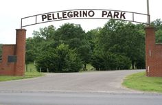
WMaria Pellegrino Park is a municipal park in the western of portion of Marble Hill, Missouri. The park is the largest of the five reserves in the municipality. Pellegrino Park features tennis courts, pavilions, playground equipment, picnic tables, restroom facilities, forest, and a two acre lake for fishing. The park began planning in 1969 and was established in 1972 on 31 acres of city owned land. The park was founded by Frank Pellegrino, the former president and chairman of the International Hat Company of St. Louis. The company operated one of its factories in Marble Hill until 1989, employing approximately 300 people. The park was built on land donated by the company located directly adjacent to International Hat's manufacturing plant. Pellegrino named the park in honor of his Italian-American mother, Maria Pellegrino. The plaque located at the entrance gate reads that the park is dedicated to her "as an expression of her concern for the betterment of her fellowman."
 W
WMark Twain National Forest (MTNF) is a U.S. National Forest located in the southern half of Missouri. MTNF was established on September 11, 1939. It is named for author Mark Twain, a Missouri native. The MTNF covers 3,068,800 acres (12,419 km2) of which 1,506,100 acres (6,095 km2) is public owned, 78,000 acres (320 km2) of which are Wilderness, and National Scenic River area. MTNF spans 29 counties and represents 11% of all forested land in Missouri. MTNF is divided into six distinct ranger districts: Ava-Cassville-Willow Springs, Eleven Point, Houston-Rolla, Cedar Creek, Poplar Bluff, Potosi-Fredericktown, and the Salem. The six ranger districts actually comprise nine overall unique tracts of forests. Its headquarters are in Rolla, Missouri.
WThe Ozark National Scenic Riverways is a national park in the Ozarks of southern Missouri in the U.S..
 W
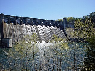
WNorfork Dam is a large dam in northern Arkansas southeast of Mountain Home. It dams North Fork River and creates Norfork Lake. The top of the dam supports a 2-lane roadway, part of AR 177.
 W
WOenothera macrocarpa, the bigfruit evening primrose, Ozark sundrop or Missouri evening primrose, is a species of flowering plant in the evening primrose family Onagraceae, native to Mexico and the south-central United States, where it is found in calcareous prairies and limestone outcrops.
 W
WOttawa County is a county located in the northeastern corner of the U.S. state of Oklahoma. As of the 2010 census, the population was 31,848. Its county seat is Miami. The county was named for the Ottawa Tribe of Oklahoma. It is also the location of the federally recognized Modoc Tribe of Oklahoma and the Quapaw Tribe of Indians, which is based in Quapaw.
 W
WThe Ozark big-eared bat is an endangered species found only in a small number of caves in Arkansas, Oklahoma and Missouri, the southern central United States. Also known as the western big-eared bat, the long-eared bat, and the lump-nosed bat, its appearance is defined by a pair of outsize ears and a lump-adorned nose. The Ozark big-eared bat is the largest and reddest of the five subspecies of Corynorhinus townsendii and is medium-sized and weighs from 0.2 to 0.5 ounces. It has very large, 1-inch-long ears that connect at the base across the forehead. The snout has large, prominent lumps above the nostrils. These particular bats feed on moths and other insects; they forage along forest edges.
 W
WThe Ozark Mountain forests are a temperate broadleaf and mixed forests ecoregion of the central United States delineated by the World Wide Fund for Nature. The ecoregion covers an area of 23,900 square miles in northern Arkansas and eastern Oklahoma.
WThe Ozarks, also known as the Ozark Mountains or Ozark Plateau, is a physiographic region in the U.S. states of Missouri, Arkansas, Oklahoma and the extreme southeastern corner of Kansas. The Ozarks cover a significant portion of northern Arkansas and most of the southern half of Missouri, extending from Interstate 40 in central Arkansas to Interstate 70 in central Missouri.
WOenothera macrocarpa, the bigfruit evening primrose, Ozark sundrop or Missouri evening primrose, is a species of flowering plant in the evening primrose family Onagraceae, native to Mexico and the south-central United States, where it is found in calcareous prairies and limestone outcrops.
 W
WScouting in Missouri has a long history, from the 1910s to the present day.
WHamamelis vernalis is a species of witch-hazel native to the Ozark Plateau in central North America, in Missouri, Oklahoma, and Arkansas.
 W
WThe Ozark – St. Francis National Forest is a United States National Forest that is located in the state of Arkansas. It is composed of two separate forests, Ozark National Forest in the Ozark Mountains; and St. Francis National Forest on Crowley's Ridge. Each forest has distinct biological, topographical, and geological differences.
 W
WUniversity of the Ozarks is a private university in Clarksville, Arkansas. Enrollment averages around 900 students, representing 25 countries. U of O is affiliated with the Presbyterian Church (U.S.A.).
 W
WRichland Creek Wilderness is located in the U.S. state of Arkansas. Created by an act of Congress in 1984, the wilderness covers an area of 11,801 acres (48 km²). Contained within Ozark-St. Francis National Forest, the wilderness is managed by the U.S. Forest Service.
 W
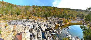
WA shut-in is a type of rock formation found in Ozarks streams where they carve through a mountain range, causing a complex of pools, rivulets, rapids and plunge pools. Shut-ins are inherently confined to a narrow valley or canyon, with the river valley widening out both above and below the formation. Because the rock resists downcutting, streams typically descend at relatively steep gradient through shut-ins, with the downstream terminus of the formation often marked by a very large plunge pool. The river becomes unnavigable at shut-ins even by canoe due to the rapids and narrow channels.
 W
WThe Southeast Missouri Lead District, commonly called the Lead Belt, is a lead mining district in the southeastern part of Missouri. Counties in the Lead Belt include Saint Francois; Crawford; Dent; Iron; Madison: Reynolds; and Washington. Philip Francois Renault of France led a large exploratory mission in 1719 and started mining operations in Old Mines and Mine La Motte in 1720. The town of Sainte Genevieve was founded as a river port for transportation of lead out of the area. Moses Austin started large-scale mining and smelting at Potosi, originally known as Mine a Breton, and founded Herculaneum as his shipping point on the Mississippi. This lead was originally used as a roofing material. Bonne Terre has large subterranean mines, now used commercially for recreational scuba diving.
 W
WTable Rock Lake, designed, built and operated by the U.S. Army Corps of Engineers, is an artificial lake or reservoir in the Ozarks of southwestern Missouri and northwestern Arkansas. The lake is impounded by Table Rock Dam, constructed from 1954 to 1958 on the White River by the U.S. Army Corps of Engineers.
 W
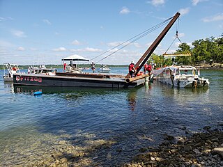
WOn the evening of July 19, 2018, a duck boat operated by Ride the Ducks sank on Table Rock Lake in the Ozarks near Branson, Missouri, in the United States. The amphibious vehicle sank with 31 people on board, leaving 17 dead, during high winds associated with nearby severe thunderstorms.
 W
WLake Taneycomo is a man-made lake or reservoir on the White River in the Ozark Mountains of Taney County, Missouri. The reservoir is named for the county in which it is located: Taney County, MO.
 W
WThe Ozark Trail was a network of locally maintained roads and highways organized by the Ozark Trails Association that predated the United States federal highway system. The roads ran from St. Louis, Missouri, to El Paso, Texas, and Santa Fe, New Mexico, over a series of routes. These roads were maintained by both private citizens and local communities. In one case, however, the U.S. government was directly involved; it built the Newcastle Bridge in 1923 over the South Canadian River between Newcastle, Oklahoma, and Oklahoma City, as the first federal highway project built in Oklahoma.
 W
WThe Ozark Trail is a hiking, backpacking, and, in many places, biking and equestrian trail under construction in the Missouri Ozarks in the United States. It is intended to reach from St. Louis to Arkansas. Over 350 miles (563 km) of the trail have been completed as of 2008, and the estimated length when finished will be at least 500 miles (805 km). When joined to the Ozark Highlands Trail in Arkansas, the full hiking distance from end to end will be at least 700 miles (1,127 km), not including a large loop through the St. Francois Mountains in Missouri.
 W
WTemplate:Unreferefnced
 W
WU.S. Route 62 is a U.S. highway running from El Paso, Texas northeast to Niagara Falls, New York. In the U.S. state of Arkansas, the route runs 329.9 miles from the Oklahoma border near Summers east to the Missouri border in St. Francis, serving the northern portion of the state. The route passes through several cities and towns, including Fayetteville, Springdale, Bentonville, Harrison, Mountain Home, Pocahontas, and also Piggott. US 62 runs concurrent with several highways in Arkansas including Interstate 49 and U.S. Route 71 between Fayetteville and Bentonville, U.S. Route 412 through much of the state, U.S. Route 65 in the Harrison area, and with U.S. Route 63 and U.S. Route 67 in northeast Arkansas.
 W
WUpper Buffalo Wilderness is located in the U.S. state of Arkansas. Created by an act of Congress in 1974, the wilderness covers an area of 12,108 acres (49 km²). Contained within Ozark-St. Francis National Forest, the wilderness is managed by the U.S. Forest Service. Contained in the wilderness is Hawksbill Crag, a very popular hiking destination.