 W
WAmasing Hill consists of three small andesitic volcanoes. The volcanic complex is located on Bacan island at the west of Halmahera island, Indonesia. The two volcanoes, Cakasuanggi and Dua Saudara, were constructed in the southeast. The other volcano, Sibela Mountains, is a metamorphic complex of volcano.
 W
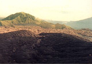
WAnak Krakatoa is an island in a caldera in the Sunda Strait between the islands of Java and Sumatra in the Indonesian province of Lampung. On December 29, 1927, Anak Krakatoa emerged from the caldera formed in 1883 by the explosive volcanic eruption that destroyed the island of Krakatoa. There has been sporadic eruptive activity at the site since the late 20th century, culminating with a large underwater collapse of the volcano which caused a deadly tsunami in December 2018, followed by subsequent activity in 2019 and an eruption in April 2020. Due to its young age, the island is one of several in the area which are of considerable interest to volcanologists, and the subject of extensive study.
 W
WMount Awu is the largest volcano in the Sangihe chain, located in North Sulawesi, Indonesia. Powerful eruptions occurred in 1711, 1812, 1856, 1892 and 1966 with devastating pyroclastic flows and lahars that have resulted in more than 8,000 fatalities altogether. A 4.5 km wide crater is found at the summit and a deep valley forms a passageways for lahars, splitting the flanks from the crater. This is a volcano in the Ring of Fire.
 W
WMount Binaiya is the highest point on the Indonesian island of Seram. At an elevation of 3,027 metres (9,931 ft), it is one of the one hundred most topographically prominent peaks on Earth.
 W
WBukit Lumut Balai is a heavily eroded stratovolcano on Sumatra island, Indonesia. It consist of three eruption centers, two on the Bukit Lumut and one on the north-east side of the Bukit Balai. A large lava flow occurs on the north side of Bukit Balai. Active fumarole fields are found in two crescentic basins to the north of Bukit Lumut.
 W
WDukono is an active volcano located in the northern part of Halmahera island, Indonesia. It has a broad profile and is capped by compound craters. During the major eruption in 1550, a lava flow filled in the strait between Halmahera and the north flank cone of Mount Mamuya. It was an eruption of scale 3 on VEI. Deaths were reported but the figure is unknown. Smaller eruptions occurred in 1719, 1868, and 1901. Since 1933, Dukono has been erupting continuously until the present.
 W
WGamalama is a near-conical stratovolcano that comprises the entire Ternate island in Indonesia. The island lies off the western shore of Halmahera island in the north of the Maluku Islands. For centuries, Ternate was a center of Portuguese and Dutch forts for spice trade, which have accounted for thorough reports of Gamalama's volcanic activities.
 W
WMount Gamkonora is a stratovolcano on Halmahera island, Indonesia. With an elevation of 1,560 metres (5,118 ft), it is the highest peak on the island. It has produced an elongated series of craters along the north–south rift. The largest eruption in 1673 was accompanied by a tsunami which inundated the nearby villages. Between 1564 and 1989 the volcano erupted twelve times.
WHiri is a small, 3-kilometre-wide forested island immediately north of the island of Ternate, in the Maluku Islands of Indonesia. It is located at the northernmost part of a chain of volcanic islands off the western coast of Halmahera. It is a conical volcano which rises to 630 m (2,067 ft). The island covers 6.7 km2 and had a population of 3,064 in 2015;; it is administered as a district (kecamatan) of the City of Ternate. Its dominant neighbour to the south is the more active volcano of Mount Gamalama, on Ternate island.
WHulubelu is an elliptical, 4-km-long caldera the floor of which is about 700 m above sea level and is surrounded by steep walls in South-Eastern Sumatra. Post-caldera volcanism formed central cones and basaltic and andesitic flank volcanoes. Solfataric areas, mud volcanoes, and hot springs occur at several locations but it is not known for sure when the volcano last erupted, possibly in the Holocene epoch. Thermal areas are aligned North East of and parallel to the Great Sumatran fault, which runs the entire length of the island of Sumatra.
 W
WMount Ibu is a stratovolcano at the north-west coast of Halmahera island, Indonesia. The summit is truncated and contains nested craters. The inner crater is 1 km (0.62 mi) wide and 400 m (1,312 ft) deep, while the outer is 1.2 km (0.75 mi) wide. A large parasitic cone is at the north-east of the summit and a smaller one at the south-west. The latter feeds a lava flow down the west flank. A group of maars are on the western and northern side of the volcano.
 W
WMount Ilas Bungaan is a limestone hill near Berau, East Kalimantan, Borneo. It is also known as Flowering Rock, a literal translation of its Indonesian name. The hill is located "on a remote stretch of the Karangan River" and its base lies at an altitude of around 300 m.
 W
WIlilabalekan is a volcano located in the south-central part of the island of Lembata, Indonesia.
 W
WIliwerung is a volcano in the south-central part of the island Lembata in Indonesia.
WMount Kapalatmada is a mountain in the Maluku Islands, Indonesia. At an elevation of 2,428 metres (7,966 ft) above sea level, it is the highest point on the Indonesian island of Buru.
 W
WKarangetang is a volcano on the north side of Siau Island off the coast of Sulawesi, Indonesia. The island is inhabited by 22,000 people. It is one of the most active volcanoes in Indonesia having erupted 41 times since 1675. A pyroclastic flow in 1997 killed three people.
 W
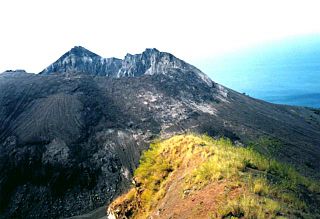
WKrakatoa, or Krakatau, is a caldera in the Sunda Strait between the islands of Java and Sumatra in the Indonesian province of Lampung. The caldera is part of a volcanic island group comprising four islands: two of which, Lang and Verlaten, are remnants of a previous volcanic edifice destroyed in eruptions long before the famous 1883 eruption; another, Rakata, is the remnant of a much larger island destroyed in the 1883 eruption.
 W
WMount Lawit is a mountain on the island of Borneo. It is 1767 metres tall and sits on the international border between Indonesia and Malaysia. On the Indonesian side of the border, the mountain is within the Betung Kerihun National Park.
 W
WMount Ile Lewotolok or Ile Lewotolok Volcano is a stratovolcano located in the north-central part of the island of Lembata, Indonesia.
 W
WBatu Tara stratovolcano is a volcano located on the small isolated Komba Island in the Flores Sea in Indonesia. Vegetations covers the flanks of Batu Tara. The first historical eruption occurred in 1852 with explosions and lava flows.
 W
WColo is a stratovolcano in Indonesia. It forms the small island of Una-Una at the middle of the Gulf of Tomini, the northern part of Sulawesi. The volcano is broad and has a low profile with only 507 metres (1,663 ft) above the sea level. It contains a 2 kilometres (1.2 mi) wide caldera with a small volcanic cone inside. Only three eruptions have been recorded in the history with two of them causing damage.
 W
WRuang is the southernmost stratovolcano in the Sangihe Islands arc. It comprises an island 4 × 5 km wide. The summit contains a partial lava dome, and reaches some 2,379 ft in altitude. From its summit, Klabat's peak in the south, that of Siau to the north, and Ternate to the east can all be seen.
WMount Mutis, also known as Nuaf Nefomasi, is a mountain and highest point of East Nusa Tenggara, Indonesia, at 2,427 metres (7,963 ft) above sea level. It is located in the Gunung Mutis Nature Reserve in the South Central Timor Regency, 150 km (93 mi) from Kupang, around 40 km (25 mi) north of the town of Soe. The mountain is a popular climbing site.
 W
WThis list of highest mountains of New Guinea shows all mountains on the island of New Guinea that are at least 3750 m high and have a topographic prominence of 500 m or more. These c. 50 peaks are also the highest mountains of Australasia and the continent of Australia, where, outside New Guinea, the highest mountain is Aoraki / Mount Cook in New Zealand with a height of 3724 m. A list of highest mountains of Oceania with the same limitations is almost identical, with the addition of the Hawaiian volcanoes of Mauna Kea and Mauna Loa in 18th and 20th positions. The list also shows the 36 highest thus defined mountains of Indonesia, except for the 3805 m high Gunung Kerinci on Sumatra, and the 16 highest mountains of Papua New Guinea.
 W
WNgga Pilimsit is a mountain located in the Indonesian province of Papua, in the Maoke Mountains. It rises 4,717 meters (15,476 ft). It is a little over thirteen miles west-northwest of Puncak Jaya, the highest peak of Oceania and Indonesia. The nearest peaks are Carstensz Pyramid, Wataikwa, Ubia, Venusberg, Otakwa, and Papua Peak 4061. Dependent on the definition used for an independent mountain, the peak ranks as the fourth to seventh highest mountain on New Guinea and in Indonesia.
 W
WNgga Pulu is a summit on the north rim of Mount Carstensz in the western part of the island of New Guinea rising 4,862 metres (15,951 ft). Trigonometric measurements showed that Ngga Pulu was the highest mountain of New Guinea and also the highest summit of the Australia-New Guinea continent. The elevation of Ngga Pulu in 1936 was about 4,907 m (16,099 ft), and it was the highest and most prominent peak between the Himalaya and the Andes. However, due to glacial melting, Ngga Pulu lost a lot of elevation in the 20th century.
 W
WNokilalaki Mountain is a mountain located in Palolo, Sigi Regency, Central Sulawesi, Indonesia. It has an elevation of 2,357 meters (7,733 ft).
 W
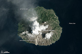
WPaluweh, also known as Rokatenda, is a stratovolcano that forms the small island of Palu'e, north of Flores Island in Sikka Regency in the province of East Nusa Tenggara, Indonesia. While the volcano rises about 3,000 m (9,840 ft) above the sea floor, its cone rises just 875 metres (2,871 ft) above sea level and is the highest point on the island.
 W
WPlawangan is a hill above the town of Kaliurang, on the southern slopes of Gunung Merapi, Central Java, in Indonesia. It is east of Turgo, which is another named hill above Kaliurang.
 W
WMount Pueh, also known as Mount Pueh-Berumput, Mount Poi and Mount Poe, is a mountain located near Lundu, Sarawak on the Malaysia-Indonesia border. Mount Pueh was known to biologists for the collections made there by Eric Mjöberg (1882–1938), a Swedish naturalist, who was Curator of the Sarawak Museum between 1922–1924. Mjöberg's herpetological collections from Gunung Pueh between October to December 1923, and other localities in Borneo, were reported by Smith (1925). Mjöberg, unfortunately, left little by way of written records, of his ascent of Pueh and the collections he made.
 W
WMount Rinjani is an active volcano in Indonesia on the island of Lombok. Administratively the mountain is in the Regency of North Lombok, West Nusa Tenggara. It rises to 3,726 metres (12,224 ft), making it the second highest volcano in Indonesia.
 W
WSangeang Api is an active complex volcano on the island of Sangeang in Indonesia. It consists of two volcanic cones, 1,949 metres (6,394 ft) Doro Api and 1,795 m (5,889 ft) Doro Mantoi. Sangeang Api is one of the most active volcanoes in the Lesser Sunda Islands. It erupted in 1988 and the island's inhabitants were evacuated. Between its first recorded eruption in 1512 and 1989 it erupted 17 times. It erupted again during December 2012 and May 2014.
 W
WMount Sirung is an active volcano complex volcano located on Pantar Island in the Alor archipelago of the eastern Indonesian province of Nusa Tenggara Timor. The crater rim can be reached by an easy hike from the village of Kakamauta. Inside the crater is a large sulphurous crater lake and several active steam vents. The last major eruption occurred 1970, and regular gas and clastic eruptions have occurred since 2004. A small eruption beginning May 12, 2012 triggered an evacuation of an area within a 1.5 km radius of the caldera.
 W
WMount Tambora, or Tomboro, is an active stratovolcano in the northern part of Sumbawa, one of the Lesser Sunda Islands of Indonesia. It was formed due to the active subduction zones beneath it, and before its 1815 eruption, it was more than 4,300 metres high, making it one of the tallest peaks in the Indonesian archipelago.
WTarakan volcano is located in Indonesia's Halmahera islands, near the shore of Galela Bay north east of Dukono volcano. Tarakan consists of two large cinder cones, namely Tarakan Lamo and Tarakan Itji.
 W
WTurgo is a small basaltic hill on the southern slopes of Gunung Merapi, Central Java, Indonesia, and is also known as Gunung Turgo or Mount Turgo. Recent work suggests that the hill itself is older than the present volcanic cone of Gunung Merapi. It is just west of Plawangan, the valley between the two has been subject to nuée ardente in the 1990s which killed local villagers.
 W
WWayang-Windu is a twin volcano that consists of Mount Wayang and Mount Windu. They are located just to the east of the town of Pangalengan in the Bandung Regency in West Java, Indonesia, about 40 km (25 mi) south of the city of Bandung. The area has been an active geothermal project. Mount Wayang has a 750 m (2,500 ft) wide crescentic crater which holds four groups of fumaroles. Mount Windu has a 350 m (1,100 ft) wide crater.