 W
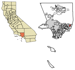
WThe Pomona Valley is located in the Greater Los Angeles Area between the San Gabriel Valley and San Bernardino Valley in Southern California. The valley is approximately 30 miles east of downtown Los Angeles, which can often be seen from nearby foothills. It ranges from the city of San Dimas from the far west to Rancho Cucamonga to the far east portion of the valley. The alluvial valley is formed by the Santa Ana River and its tributaries.
 W
WArea codes 840 and 909 are California telephone area codes that cover far eastern Los Angeles County and southwestern San Bernardino County. The 909 area code was split from area code 714 on November 14, 1992. By August 1993 use of the new area code became mandatory. Western Riverside County was split off from 909 into area code 951 on July 17, 2004. 909 still covers small portions of Corona, Riverside, and Moreno Valley, which are in Riverside County.
 W
WBrea is a city in northern Orange County, California. The population as of the 2010 census was 39,282. It is 33 miles (53 km) southeast of Los Angeles. Brea is part of the Los Angeles metropolitan area.
 W
WState Route 66 is a state highway in the U.S. state of California that runs along a section of old U.S. Route 66 in Los Angeles and San Bernardino counties. It goes from State Route 210 in La Verne east to Interstate 215 in San Bernardino, passing through Claremont, Upland, Rancho Cucamonga, Fontana and Rialto along Foothill Boulevard. In San Bernardino, it is the part of Fifth Street west of H Street.
 W
WState Route 71 is a 15-mile (24 km) state highway in the U.S. state of California. Serving Riverside, San Bernardino, and Los Angeles counties, it runs from SR 91 in Corona to the Interstate 10/SR 57/Kellogg Interchange at the Pomona–San Dimas boundary. The segment from SR 91 to SR 83 in Chino Hills is called the Corona Freeway, formerly the Corona Expressway and before then the Temescal Freeway. SR 71 is designated as the Chino Valley Freeway between SR 83 and the Kellogg Interchange.
 W
WCalifornia's 20th State Senate district is one of 40 California State Senate districts. It is currently represented by Democrat Connie Leyva of Chino.
 W
WCalifornia's 35th congressional district is a U.S. congressional district in California.
 W
WCalifornia's 52nd State Assembly district is one of 80 California State Assembly districts. It is currently represented by Democrat Freddie Rodriguez of Pomona.
 W
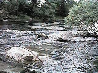
WChino Creek is a major stream of the Pomona Valley, in the western Inland Empire region of Southern California. It is a tributary of the Santa Ana River.
 W
WChino Hills is a city located in the southwestern corner of San Bernardino County, California, United States. The city borders Los Angeles County on its northwest side, Orange County to its south and southwest, and Riverside County to its southeast.
WState Route 71 is a 15-mile (24 km) state highway in the U.S. state of California. Serving Riverside, San Bernardino, and Los Angeles counties, it runs from SR 91 in Corona to the Interstate 10/SR 57/Kellogg Interchange at the Pomona–San Dimas boundary. The segment from SR 91 to SR 83 in Chino Hills is called the Corona Freeway, formerly the Corona Expressway and before then the Temescal Freeway. SR 71 is designated as the Chino Valley Freeway between SR 83 and the Kellogg Interchange.
 W
WChino is a city in the western end of San Bernardino County, California, United States, with Los Angeles County to its west and Orange County to its south in the Southern California region. Chino is adjacent to Chino Hills, California. Chino's surroundings have long been a center of agriculture and dairy farming, providing milk products in Southern California and much of the southwestern United States. Chino's agricultural history dates back to the Spanish land grant forming Rancho Santa Ana del Chino. The area specialized in orchard, row crops and dairy.
The Claremont Courier is a community newspaper based in Claremont, California, United States. It is widely regarded as the city's newspaper of record, and is often cited by other news outlets covering the city. In 2018, the Courier was named the top community newspaper in California by the California News Publishers Association. It publishes an annual almanac and is known for its aerial videography.
 W
WClaremont is a city on the eastern edge of Los Angeles County, California, United States, 30 miles (48 km) east of downtown Los Angeles. It is in the Pomona Valley, at the foothills of the San Gabriel Mountains. As of the 2010 census it had a population of 34,926, and in 2019 the estimated population was 36,266.
 W
WThe Cucamonga Valley AVA is an American Viticultural Area in San Bernardino County, California. It is in the Cucamonga Valley region of the Pomona Valley, about 15 miles (24 km) west of San Bernardino.
 W
WDeclezville is an unincorporated community in southwestern San Bernardino County, in the Inland Empire region of southern California.
WGuasti, formerly known as South Cucamonga and Zucker, is an unincorporated community in the Cucamonga Valley region of the Pomona Valley, in southwestern San Bernardino County, California.
 W
WHofer Ranch is a historic ranch with ranch house, located at 11248 South Turner Avenue in Ontario, located in the Pomona Valley and San Bernardino County, in southern California.
The Inland Empire Utilities Agency (IEUA) is a regional wastewater facility and wholesale supplemental water supplier in southwestern San Bernardino County, in the Inland Empire region of Southern California.
 W
WThe Jurupa Mountains are a small mountain range of the Peninsular Ranges System, located in the southeastern Pomona Valley, within northwestern Riverside County and southwestern San Bernardino County of the Inland Empire region, southern California.
 W
WLa Casa Alvarado, also known as the Alvarado Adobe, is a historic adobe structure built in 1840 and located on Old Settlers Lane in Pomona, California. It was declared a historic landmark in 1954 and added to the National Register of Historic Places in 1978.
 W
WLa Casa Primera de Rancho San Jose is a historic adobe structure built in 1837 in Pomona, California. It is the oldest home located in the Pomona Valley and in the old Rancho San Jose land grant. It was declared a historic landmark in 1954 and added to the National Register of Historic Places in April 1975.
 W
WLa Verne is a small city in Los Angeles County, California, United States. The population was 31,063 at the 2010 census, down from 31,638 at the 2000 census.
 W
WMontclair is a city in the Pomona Valley, in southwestern San Bernardino County, California. The population was 36,664 in the 2010 United States Census.
 W
WOntario is a city in southwestern San Bernardino County, California, 35 miles (56 km) east of downtown Los Angeles and 23 miles (37 km) west of downtown San Bernardino, the county seat. Located in the western part of the Inland Empire metropolitan area, it lies just east of Los Angeles County and is part of the Greater Los Angeles Area. As of the 2010 Census, the city had a population of 163,924, up from 158,007 at the 2000 census.
 W
WState Route 60 is an east-west state highway in the U.S. state of California. It serves the cities and communities on the eastern side of the Los Angeles metropolitan area and runs along the south side of the San Gabriel Valley. It functions as a bypass route of Interstate 10 (I-10) through the area between the East Los Angeles Interchange in Los Angeles and Beaumont. SR 60 provides a route across several spurs of the Peninsular Ranges, linking the Los Angeles Basin with the Pomona Valley and San Gabriel Valley. The highway also overlaps at State Route 57 and Interstate 215.
 W
WRancho Cucamonga is a city located just south of the foothills of the San Gabriel Mountains and Angeles National Forest in San Bernardino County, California, United States. About 37 miles (60 km) east of Downtown Los Angeles, Rancho Cucamonga is the 26th most populous city in California. The city's seal, which centers on a cluster of grapes, alludes to the city's agricultural history including wine-making. The city's proximity to major transportation hubs, airports, and highways has attracted the business of several large corporations, including Coca-Cola, Frito-Lay, Big Lots, Mercury Insurance Group, Southern California Edison, and Amphastar Pharmaceuticals.
 W
WRancho Santa Ana del Chino was a 22,193-acre (89.81 km2) Mexican land grant in the Chino Hills and southwestern Pomona Valley, in present-day San Bernardino County, California.
 W
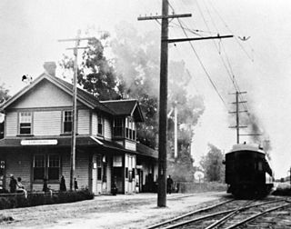
WRiverside–Rialto was a line operated by the Pacific Electric Railway from 1914 to 1940, running from Downtown Los Angeles to Downtown Riverside. This was the longest service in the Pacific Electric system, and the only line to have exclusive trackage owned by the Union Pacific instead of the Southern Pacific Railroad. The line reached its highest ridership the year it opened but never recovered at a time when the Inland Empire was far less populated and a commute of that distance was rare.
 W
WSan Antonio Heights is a census-designated place (CDP) in San Bernardino County, California. It is in the northern Pomona Valley and the foothills of the San Gabriel Mountains. The population was 3,371 at the 2010 census, up from 3,122 at the 2000 census.
 W
WThe San Bernardino Line is a Metrolink line running between Downtown Los Angeles east through the San Gabriel Valley and the Inland Empire to San Bernardino. It is one of the three initial lines on the original Metrolink system.
 W
WSan Dimas is a city in the San Gabriel Valley of Los Angeles County, California, United States. As of the 2010 census, the city had a total population of 33,371. The city historically took its name from San Dimas Canyon in the San Gabriel Mountains above the northern section of present-day San Dimas. San Dimas derives its name from the Spanish name for Saint Dismas.
 W
WThe San Jose Hills are a part of the Transverse Ranges located in Eastern Los Angeles County, California, marking the border between the San Gabriel Valley and the Pomona Valley. It includes portions of Covina, West Covina, Walnut, Pomona, and San Dimas. To the south, the valley of San Jose Creek separates the San Jose Hills from the Puente Hills and Chino Hills.
 W
WThe Upland–San Bernardino Line was an interurban line operated by the Pacific Electric Railway between Downtown Los Angeles and San Bernardino, California. This line also had shorter service that terminated before the end of the line at Baldwin Park, Covina, and San Dimas. Though service along this line in its entirety was discontinued in November 1941, it stands as the fourth-longest rapid transit line in American history, after the Sacramento Northern Chico and Colusa services, and the Pacific Electric's own Riverside–Rialto Line.
 W
WUpland is a city in San Bernardino County, California, United States. The municipality is located at an elevation of 1,242 feet. As of the 2010 census, the city had a population of 73,732, up from 68,393 at the 2000 census. It was incorporated on May 15, 1906, after previously being named North Ontario. Upland is located at the foot of the highest part of the San Gabriel Mountains. The Los Angeles suburb is part of the Inland Empire, a metropolitan area situated directly east of the Los Angeles metropolitan area.
 W
WThe Ygnacio Palomares Adobe, also known as Adobe de Palomares, is a one-story adobe brick structure in Pomona, California, built between 1850 and 1855 as a residence for Don Ygnacio Palomares. It was abandoned in the 1880s and was left to the elements until it was acquired by the City of Pomona in the 1930s. In 1939, the adobe was restored in a joint project of the City of Pomona, the Historical Society of Pomona Valley and the Works Project Administration. Since 1940, it has been open to the public as a museum on life in the Spanish and Mexican ranchos. It was listed on the National Register of Historic Places in 1971. Of the more than 400 sites in Los Angeles County that have been listed on the National Register, fewer than ten received the distinction prior to the Ygnacio Palomares Adobe.