 W
WGlacier National Park is an American national park located in northwestern Montana, on the Canada–United States border, adjacent to the Canadian provinces of Alberta and British Columbia. The park encompasses over 1 million acres (4,000 km2) and includes parts of two mountain ranges, over 130 named lakes, more than 1,000 different species of plants, and hundreds of species of animals. This vast pristine ecosystem is the centerpiece of what has been referred to as the "Crown of the Continent Ecosystem," a region of protected land encompassing 16,000 square miles (41,000 km2).
 W
WThe Adair Peak Fire was a wildfire in Glacier National Park in the U.S. state of Montana and was first reported on August 12, 2017 around 10:17 AM after it was caused by a lightning storm over the region that occurred several days before it was first spotted. The Adair Peak Fire encompassed 4,074 acres (1,649 ha). The fire forced the closure of the North Fork Road from the Polebridge Ranger Station south to Camas Creek as well as the Logging Creek and Quartz Creek campgrounds. Structure protection was performed at the Lower Logging Lake Snowshoe Cabin and Boathouse by a small firefighting crew that wrapped the structures with a fire resistant sheeting. The fire was started by the same dry lightning storm that ignited the Sprague Fire near Lake McDonald that destroyed the Sperry Chalet on August 31.
 W
WApgar Village is one of the main villages in Glacier National Park. Apgar is located on the west side of the park about one mile in from the West Entrance. Apgar has one of the most popular campgrounds in Glacier Park, and is always quite filled. Apgar Village is also home to a visitors' center, a general store, and a large gift shop. Apgar Village is also the starting point for almost all Red Jammer bus tours on the Going-to-the-Sun Road. Apgar's campground is connected to the village by a road, and a bike path through the woods, in which smaller wildlife can be seen, though Grizzly bears have been seen close to camp.
 W
WAppekunny Formation is a thick series of rock strata located in the Lewis Range within Glacier National Park, in the U.S. state of Montana. The formation is primarily mudstone and siltstone deposited in a shallow sea during the Proterozoic. Not far from the eastern entrance to the Going-to-the-Sun Road at St. Mary, Montana, the formation can be easily seen on the slopes of Singleshot Mountain. The Appekunny Formation contains bedding structures which may include the remains of the oldest metazoan (animal) on Earth known by the species name Horodyskia moniliformis.
 W
WThe List of Glacier National Park (U.S.) references identifies English language historic, scientific, ecological, cultural, tourism, social, and advocacy books, journals and studies on the subject of Glacier National Park (U.S.) topics published since 1870 and documented in Glacier related bibliographies and other related references.
 W
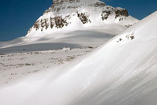
WThe Big Drift is in Glacier National Park, in the U.S. state of Montana and is an area along the Going-to-the-Sun Road where a large amount of winter snow can accumulate to depths of 80 feet (24 m). Located immediately east of Logan Pass, the westerly winds push snow over the crest of the Continental Divide onto the eastern flank of a long arête which extends south from Pollock Mountain. West of the divide, this arête is known as the Garden Wall.
 W
WThe Boundary Fire is a wildfire in Glacier National Park in the U.S. state of Montana. First reported in the evening of August 23, 2018, the fire is located slightly more than a mile west of Waterton Lake in the Boundary Creek Valley near Campbell Mountain. The fire straddles the international border but did not cross into Waterton Lakes National Park in Alberta, Canada. After it was detected on August 23, the fire quickly grew to more than 1,500 acres (610 ha) over the next two days but cooler and wetter weather conditions prevented significant growth after that. Firefighters were deployed to the Goat Haunt region to install sprinklers and be prepared for structure protection. By September 9 the fire was reported as being 2,896 acres (1,172 ha) and only 12 percent contained.
 W
WThe Chief Mountain Border Crossing connects the town of Babb, Montana with Pincher Creek, Alberta on the Canada–US border. This crossing, reached by Montana Highway 17 from the American side and by Alberta Highway 6 from the Canadian side, is the only road border crossing within the Waterton-Glacier International Peace Park. It is one of only two on the US-Canada border that are closed in winter.
 W
WThe Garden Wall is a steep alpine area within Glacier National Park well known during the summer months to be heavily covered in dozens of species of flowering plants and shrubs. Located along the west side of the Continental divide and extending northward from Logan Pass, the Garden Wall can be traversed via the popular Highline Trail and for a distance of over 5 mi (8.0 km) to the Granite Park Chalet. The Going-to-the-Sun Road also passes through portions of the Garden Wall northwest of Logan Pass. The Weeping Wall is a short stretch of the Going-to-the-Sun Road where water cascades over the Garden Wall to the roadway below. The Garden Wall is an arête or rock spine that separates the Many Glacier region of the park from Lake McDonald valley.
The Glacier Institute is a 501(c)(3) non-profit corporation located in Columbia Falls, Montana. According to the U.S. National Park Service, the Glacier Institute provides field-based learning experiences to the public, and serves as an official partner to the Glacier National Park, specializing in field seminars. The Glacier Institute also conducts fund-raising activities for its youth programs, which take place at its Big Creek Outdoor Education Center. The institute has been featured in a book Study Science at the Glacier Institute written by Bruce Larkin. Glacier Institute has two campuses: its "Glacier Park Field Camp," located inside the West Glacier entrance of Glacier National Park, and its "Big Creek Outdoor Education Center," located in the Flathead National Forest.
 W
WThe Glacier National Park Tourist Trails, including the Inside Trail, South Circle Trail and North Circle Trail, were established in Glacier National Park to connect a series of tourist camps and hotels established by the Great Northern Railway between 1910 and 1915. Prior to the construction of the Going-to-the-Sun Road, these trails were the primary form of circulation within the park. The trail system includes a number of bridges.
 W
WGlacier View Dam was proposed in 1943 on the North Fork of the Flathead River, on the western border of Glacier National Park in Montana. The 416-foot (127 m) tall dam, to be designed and constructed by the U.S. Army Corps of Engineers in the canyon between Huckleberry Mountain and Glacier View Mountain, would have flooded in excess of 10,000 acres (4,000 ha) of the park. In the face of determined opposition from the National Park Service and conservation groups, the dam was never built.
 W
WGoat Haunt is a region of Glacier National Park in Montana, United States. Goat Haunt is located at the head of Waterton lake which is fed by the Waterton River. The headwaters for the Waterton River are located South of Goat Haunt Ranger Station at unnamed lakes located slightly higher than Nashukin Lake. The Goat Haunt area shares Waterton Lake with Waterton Lakes National Park in Canada. This area is important for reinforcing the international nature of the Waterton-Glacier International Peace Park. It also provides hiking trails that connect the United States and Canada. The region provides wildlife habitats on both sides of the border. As a largely unspoiled natural area, visitors experience an area with few facilities or amenities, but with historical importance including Waterton Townsite and mountain passes used by American Indians.
 W
WGoing-to-the-Sun Road is a scenic mountain road in the Rocky Mountains of the western United States, in Glacier National Park in Montana. The Sun Road, as it is sometimes abbreviated in National Park Service documents, is the only road that traverses the park, crossing the Continental Divide through Logan Pass at an elevation of 6,646 feet (2,026 m), which is the highest point on the road. Construction began in 1921 and was completed in 1932 with formal dedication in the following summer on July 15, 1933. The road is the first to have been registered in all of the following categories: National Historic Place, National Historic Landmark and Historic Civil Engineering Landmark. The road is approximately 50 miles (80 km) long and spans the width of the park between the east and west entrance stations. The National Historic Landmark Nomination records a slightly shorter distance of 48.7 miles which is measured from the first main intersection just outside the park's west entrance to Divide Creek in St. Mary on the east side of the park.
 W
WThe Highline Trail is a scenic hiking trail in Glacier National Park, Montana, United States. The trail stretches 7.6 miles (12.2 km) from Logan Pass to Granite Park Chalet, and continues another 11.9 miles (19.2 km) from there to Fifty Mountain Campground. The trail follows the Garden Wall ridge and the continental divide for most of its length. The trail offers scenic views of glaciated U-shaped valleys. A 1.2-mile (1.9 km) round trip side trail takes hikers up the side of the Garden Wall to an overlook to Grinnell Glacier.
 W
WThe Howe Ridge Fire was a wildfire in Glacier National Park in the U.S. state of Montana. Ignited by a thunderstorm on the evening of August 11, 2018, the fire was located on the northwest side of Lake McDonald. Several other fires were also started near the park due to the storm. On August 12 National Park Service officials issued a mandatory evacuation of private cabins and federally owned properties including the Lake McDonald Lodge complex which was temporarily closed. On August 13, National Park officials then closed the 32 miles (51 km) of the Going-to-the-Sun Road from Apgar Village to Logan Pass on the west side of the park after "extreme fire conditions" occurred the previous evening, threatening multiple structures. By August 14 the fire had spread to over 2,500 acres (1,000 ha). Though fire fighting conditions had improved by August 14, a preliminary damage assessment stated that at least seven private residences and several other structures belonging to the National Park Service had been consumed by the blaze at the Kelly's Camp Historic District and a number of other park service owned structures at the Wheeler residence. The Lake McDonald Ranger Station was saved by firefighters after its roof had been on fire. Thick haze and smoke obscured the fire on August 15 and while weather conditions remained favorable for fire growth, the haze kept the fire from spreading greatly. Haze and smoke made exact measurements of the amount of acreage burned difficult to determine, however infrared imagery indicated that the fire was 3,500 acres (1,400 ha) by August 16. By August 21 overnight infrared imagery indicated the fire had burned 9,672 acres (3,914 ha). On August 23rd the fire had nearly 200 firefighters assigned to it and had burned 10,323 acres (4,178 ha) with only 10 percent of the fire contained. Full containment was not anticipated until November 1st. Fire remained active along the northern flank between Mount Vaught and McDonald Creek as well as the southern margin on the west side of Lake McDonald and had spread to 11,519 acres (4,662 ha) by August 24 and then 12,435 acres (5,032 ha) by August 30. By August 28, cooler temperatures and widespread rain helped to keep the fire from expanding however a trend back to warmer and drier conditions was expected to provide conditions for future fire growth due to heavy fuels and terrain.
 W
WThe Lewis Range is a mountain range located in the Rocky Mountains of northern Montana, United States and extreme southern Alberta, Canada. It was formed as a result of the Lewis Overthrust, a geologic thrust fault resulted in the overlying of younger Cretaceous rocks by older Proterozoic rocks. The range is located within Waterton Lakes National Park in Alberta, Canada and Glacier National Park and the Bob Marshall Wilderness Complex in Montana, United States. The highest peak is Mount Cleveland at 10,466 ft (3,190 m).
 W
WThe following articles relate to the history, geography, geology, flora, fauna, structures and recreation in Glacier National Park (U.S.), the U.S. portion of the Waterton-Glacier International Peace Park.
 W
WThe Livingston Range is a mountain range located primarily in Glacier National Park in the U.S. state of Montana, and in the extreme southeastern section of the Canadian province of British Columbia. The range is 36 miles (58 km) long and 28 miles (45 km) wide. Over 15 summits exceed 9,000 ft (2,700 m) above sea level, and the highest point is Kintla Peak at 10,101 feet (3,079 m).
 W
WThere are at least 14 large mammal and 50 small mammal species known to occur in Glacier National Park.
 W
WMany Glacier is an area within Glacier National Park which is located in the U.S. state of Montana. The Many Glacier region is located north of the Going-to-the-Sun Road, on the east side of the park. Lake Sherburne is the large lake in the area and the Many Glacier Hotel, the largest hotel within the park, is along the shore of the adjacent Swiftcurrent Lake. The Many Glacier Hotel and surrounding buildings are a National Historic Landmark, with original construction dating back to 1915. Many Glacier is surrounded by the high peaks of the Lewis Range, and numerous hiking trails can be accessed from the area. The region is noted for numerous lakes, waterfalls and dense coniferous forests interspersed with alpine meadows. Major sites in the immediate vicinity that can be accessed by trails include Lake Josephine, Grinnell Lake, Grinnell Glacier, Cracker Lake, Granite Park Chalet, Iceberg Cirque and the Ptarmigan Tunnel, which is a hiking tunnel carved through the mountainside during the 1930s. Tour boats allow visitors an opportunity to venture onto Swiftcurrent Lake. Other activities in the region include ranger guided nature hikes, horseback riding, fishing and camping.
 W
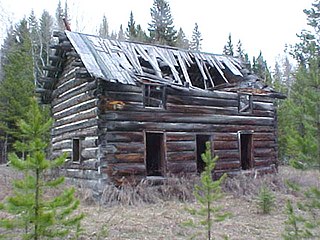
WThe J. K. Miller Homestead in Glacier National Park near Big Prairie, Montana, United States, was built in 1909. It was listed on the National Register of Historic Places in 1988. The listing included three contributing buildings and one other contributing structure.
 W
WNight of the Grizzlies (1969) is a book by Jack Olsen which details events surrounding the night of August 13, 1967, when two young women were separately attacked and killed in Glacier National Park, Montana, by grizzly bears. Both women, Julie Helgeson, 19, of Albert Lea, Minnesota, and Michele Koons, 19, of San Diego, California, died of their injuries.
 W
WThe North Fork Road in Glacier National Park was built in 1901. The Butte Oil Company constructed a rough wagon road from Lake McDonald to its oil well at Kintla Lake, encouraging the development of the North Fork region. From 1935–1945, the National Park Service developed the road adding culverts and drains. The unpaved road extends nearly forty miles, almost to the Canada–United States border.
 W
WThe Pacific Northwest Trail (PNT) is a 1200-mile hiking trail running from the Continental Divide in Montana to the Pacific Ocean on Washington’s Olympic Coast. Along the way, the PNT crosses three national parks, seven national forests, two other national scenic trails, and against the grain of several mountain ranges, including the Continental Divide, Whitefish Divide, Purcells, Selkirks, Kettles, Cascades, and Olympics. The Pacific Northwest Trail was designated as the Pacific Northwest National Scenic Trail by Congress in 2009.
 W
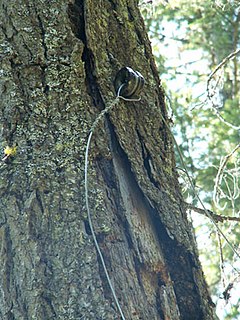
WThe Polebridge to Numa Ridge Phoneline is a historic communications path in Glacier National Park in the U.S. state of Montana. The line was the last remaining single-line crank telephone network in the American West. The remaining line, insulators, and terminals are instructive of early communication technology. The system includes the remains of a single strand system using an earth ground. Wire was strung through ceramic insulators mounted on trees. Phone poles still stand in the meadow south of Kishenehn Ranger Station, and a phone remains in place at Bowman Lake.
 W
WRed Jammers are the vintage White Motor Company/Bender Body Company Model 706 buses used at Glacier National Park in the United States to transport park visitors since 1936. While the buses are called reds for their distinctive livery, painted to match the color of ripe mountain ash berries, the bus drivers are called jammers because of the sound the gears made when the driver shifts on the steep roads of the park. The "jamming" sound came from the unsynchronised transmissions, where double-clutching was required to shift gears prior to a 1989 retrofit that added automatic transmissions.
 W
WThe Rocky Mountain Front is a somewhat unified geologic and ecosystem area in North America where the eastern slopes of the Rocky Mountains meet the plains. In 1983, the Bureau of Land Management called the Rocky Mountain Front "a nationally significant area because of its high wildlife, recreation, and scenic values". Conservationists Gregory Neudecker, Alison Duvall, and James Stutzman have described the Rocky Mountain Front as an area that warrants "the highest of conservation priorities" because it is largely unaltered by development and contains "unparalleled" numbers of wildlife.
 W
WJames Willard Schultz, or Apikuni, was a noted author, explorer, Glacier National Park guide, fur trader and historian of the Blackfeet Indians. He operated a fur trading post at Carroll, Montana 47°34′25″N 108°22′24″W and lived among the Pikuni tribe during the period 1880-82. He was given the name Apikuni by the Pikuni chief, Running Crane. Apikuni in Blackfeet means "Spotted Robe." Schultz is most noted for his 37 books, most about Blackfoot life, and for his contributions to the naming of prominent features in Glacier National Park.
 W
WThe Sprague Fire was a wildfire in Glacier National Park in the U.S. state of Montana. It was first reported on August 10, 2017 around 8:30pm after it was caused by a lightning storm. The fire encompassed 16,982 acres (6,872 ha). It nearly destroyed the historic Sperry Chalet.
 W
WSt. Mary is an unincorporated community on the western border of the Blackfeet Indian Reservation adjacent to Glacier National Park in Glacier County, Montana, United States. The village is the eastern terminus of the Going-to-the-Sun Road which bisects the park east to west, a distance of 53 mi (85 km).
 W
WThe Trail of the Cedars is a hiking trail accessible from Going-to-the-Sun Road in Glacier National Park, Montana. The .60-mile (0.97 km) path is paved and has a raised boardwalk in some sections. Some of the cedars visible are over 80 feet (24 m) tall. The trail splits into two sections: one loops, while the other continues to Avalanche Lake which can reached after a 2-mile (3.2 km) hike with a 500-foot (150 m) elevation gain. In the middle of the half loop is a beautiful waterfall that has carved through colorful rock to make a channeled stream.
 W
WTwo Medicine is the collective name of a region located in the southeastern section of Glacier National Park, in the U.S. state of Montana. It has a campground alongside Two Medicine Lake. From the period starting in the late 1890s until the completion of the Going-to-the-Sun Road in 1932, Two Medicine was one of the most visited sections of the park. Once part of a larger chalet complex, the Two Medicine Store is located along the shores of Two Medicine Lake and the building is a National Historic Landmark. The region is a starting point for many trails and tourboats take visitors out on Two Medicine Lake, where the steep south face of Rising Wolf Mountain towers above the lake. The region was considered sacred ground by several Native American tribes including the Blackfeet and they performed Vision quests here. Aside from Chief Mountain, the Two Medicine area is the most sacred section of the park to the Blackfeet.
 W
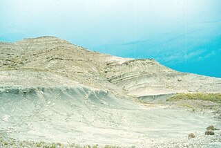
WThe Two Medicine Formation is a geologic formation, or rock body, that was deposited between 83.5 ± 0.7 Ma and 70.6 ± 3.4 Ma, during Campanian time, and is located in northwestern Montana and southern Alberta. It crops out to the east of the Rocky Mountain Overthrust Belt, and the western portion of this formation is folded and faulted while the eastern part, which thins out into the Sweetgrass Arch, is mostly undeformed plains. Below the formation are the nearshore deposits of the Virgelle Sandstone, and above it is the marine Bearpaw Shale. Throughout the Campanian, the Two Medicine Fm. was deposited between the western shoreline of the Late Cretaceous Interior Seaway and the eastward advancing margin of the Cordilleran Overthrust Belt. The Two Medicine Fm. is mostly sandstone, deposited by rivers and deltas.
 W
WThe Waterton-Glacier International Peace Park is the union of Waterton Lakes National Park in Canada and Glacier National Park in the United States. Both parks are declared Biosphere Reserves by UNESCO and their union as a World Heritage Site.
 W
WFrank Barbour Wynn was an American psychiatrist and early environmental conservationist. His father, James M. Wynn was born in 1832 and his mother, Margaret, was born in 1835. This family was listed in the 1860 US census as the most prosperous farmers on the page. His mother, Margaret, was the youngest of the five brothers and five sisters in her family. His grandparents were John and Rachel Wynn, both born in 1789.