 W
WThe 1868 Ecuador earthquakes occurred at 19:30 UTC on August 15 and 06:30 UTC on 16 August 1868. They caused severe damage in the northeastern part of Ecuador and in southwestern Colombia. They had an estimated magnitude of 6.3 and 6.7 and together caused up to 70,000 casualties. The earthquake of 15 August occurred near El Ángel, Carchi Province, close to the border with Colombia, while that of August 16 occurred near Ibarra in Imbabura Province. Reports of these earthquakes are often confused with the effects of the earthquake of 13 August at Arica.
 W
WThe 1892 Vacaville–Winters earthquakes occurred in northern California as a large doublet on April 19 and April 21. Measured on a seismic scale that is based on an isoseismal map or the event's felt area, the 6.4 Mla and 6.2 Mla events were assigned a maximum Mercalli intensity of IX (Violent), and affected the North Bay and Central Valley areas. While the total damage was estimated at between $225,000–250,000, one person was killed, but there are no reports on how many people may have been injured. No surface faulting was observed as a result of either strong shocks.
 W
WThe first of the 1894 Atalanti earthquakes occurred on 20 April 1894 at 16:52 UTC, with a magnitude of 6.4 on the moment magnitude scale and a maximum perceived intensity of X on the Mercalli intensity scale. It was followed seven days later on 27 April at 19:42 UTC by the second, with a magnitude of 6.9 and a maximum intensity of X. These two earthquakes caused widespread damage in the Locris area, causing a total of 255 deaths. More literature on these destructive events can be seen in the references section.
 W
WThe 1940 New Hampshire earthquakes struck on December 20 and again on December 24. Both shocks had an estimated Ms magnitude of 5.6, and a maximum Mercalli intensity of VII. These doublet earthquakes were the largest to hit the state in several hundred years. Damage included minor fractures or knocked over chimneys in a zone extending through New Hampshire and four other states: Maine, New York, Vermont and Massachusetts.
 W
WThe 1943 Alahan Panjang earthquakes occurred on June 8 and June 9 UTC in Sumatra, then under Japanese occupation. This was an earthquake doublet.
 W
WThe 1946 Sagaing earthquakes struck central Burma at 15:17 local time on September 12. The first earthquake registered a magnitude of 8.0 and was followed-up by an M7.8 main shock. Both events remain some of the largest in the country since the 1762 Arakan Earthquake.
 W
WThe 1949 Tierra del Fuego earthquakes occurred slightly more than eight hours apart on 17 December. Their epicenters were located in the east of the Chilean Tierra del Fuego Province, close to the Argentine border on the island of Tierra del Fuego.
 W
WThe 1956 Chim earthquake was a destructive multiple-shock event that occurred on March 16 in Lebanon along a strand of the Dead Sea Transform (DST) fault system. The epicenter was located in the south of Lebanon in the Chouf District. Six thousand homes were destroyed and another 17,000 were damaged. The number of persons killed was 136.
WAt 04:56 and 06:19 UTC on October 2, 1969, a pair of earthquakes of magnitude 5.6 and 5.7, respectively, struck the city of Santa Rosa, California, killing one person and damaging buildings. The maximum felt intensity for the two events was VII and VIII (Severe) respectively on the Mercalli intensity scale. The $8.35 million cost of the earthquakes went mostly to replace buildings damaged beyond repair. There were at least 200 aftershocks after the initial pair of earthquakes. At the time they were the largest earthquakes to affect the northern San Francisco Bay Area since the 1906 San Francisco earthquake.
 W
WThe 1971 Solomon Islands earthquakes occurred in the northern part of the Solomon Islands, within Papua New Guinea as a doublet earthquake. The first large shock occurred on July 14 at 06:11 UTC with a magnitude of Mw 8.0. The second large event occurred on July 26 at 01:23 UTC with a magnitude of Mw 8.1. The initial event on July 14 caused a tsunami, which was observed in Rabaul. The earthquake of July 26 triggered a tsunami with a 3.4 m (11 ft) runup in New Britain.
 W
WThe 1976 Longling earthquake in Yunnan Province, People's Republic of China, was a doublet earthquake, with two main shocks striking just east of Longling at 12:23:20 and 14:00:22 UTC. The magnitudes were estimated at 6.7 and 6.6, respectively, on the Mw(GCMT) scale, and 6.9 and 7.0 on the Ms scale; Chinese sources put these at 7.4 and 7.3 on the Ms7 scale. The region is noted for the quantity and intensity of its earthquakes, and the complexity of its tectonics, which are closely related to the collision between the Indian and Eurasian tectonic plates.
 W
WThe 1976 Tangshan earthquake, also known as the Great Tangshan earthquake, was a natural disaster resulting from a magnitude 7.6 earthquake that hit the region around Tangshan, Hebei, People's Republic of China on 28 July 1976, at 3:42 in the morning. In minutes, eighty-five percent of the buildings in Tangshan collapsed or were unusable, all services failed, and most of the highway and railway bridges collapsed or were seriously damaged. At least 242,000 people died, making this the third deadliest earthquake in recorded history.
 W
WThe 1982 Ometepec earthquake that struck Mexico's southwestern coast near Ometepec (Guerrero) on 7 June was a doublet earthquake that ruptured in two steps. The first happened at 06:52 UTC, the second five hours later at 10:59 UTC. Estimated magnitudes are 6.9 and 7.0 on the Ms scale, and 5.8 and 6.0 on the mb scale. The maximum MM intensities were VII and VIII, respectively.
WThe 1987 Superstition Hills earthquakes were a pair of earthquakes Mw 6.2 and 6.6 that rattled the Imperial Valley of California. The earthquakes caused damage to places in California and Mexico, and was felt as far as Las Vegas and Phoenix. Both main shocks were larger than the deadly earthquake that struck Los Angeles on October 1, which was a magnitude 5.9.
 W
WThe 1989 Chenoua earthquake occurred on October 29 at 19:09:15 local time in northern Algeria. The dip-slip event had a moment magnitude of 5.9 and a maximum Mercalli intensity of VIII (Severe). At least 22 were killed and many were injured with total losses of $5 million.
 W
WThe 1990 Vrancea earthquakes were three earthquakes on 30 and 31 May 1990 with magnitudes of 7.0 Mw and 6.2 Mw that struck the Romanian county of Vrancea, on two consecutive days. Severe damage in the Bucharest-Brăila-Brașov area was reported and dozens of casualties in Romania and neighbouring Moldova, Ukraine and Bulgaria.
 W
WThe 2000 Iceland earthquakes struck southern Iceland on June 17 and 21. There were no fatalities but three people suffered minor injuries and there was considerable damage to infrastructure. The two earthquakes were the first major seismic activity in Iceland for 88 years. The recorded magnitude of both of the main quakes was 6.5 Mwc.
WThe March 2007 Sumatra earthquakes occurred near the northern end of Lake Singkarak in Sumatra, Indonesia, on March 6. The first shock in this earthquake doublet struck with a maximum Mercalli intensity of VIII (Severe) and the second shock that arrived two hours later had a maximum Mercalli intensity of VI (Strong).
 W
WThe 2008 Iceland earthquake was a doublet earthquake that struck on May 29 at 15:46 UTC in southwestern Iceland. The recorded magnitudes of the two main quakes were 5.9 Mw and 5.8 Mw , respectively, giving a composite magnitude of 6.1 Mw . There were no human fatalities, but 30 injuries were reported and a number of sheep were killed. The epicenter of the earthquake was between the towns of Hveragerði and Selfoss, about 45 kilometers (28 mi) east-southeast of the capital, Reykjavík. It was the strongest earthquake to hit Iceland since the summer of 2000.
 W
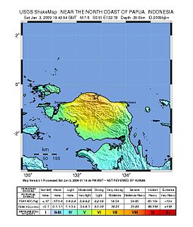
WThe 2009 Papua earthquakes occurred on January 4 local time in Indonesia's West Papua province. The very large earthquake doublet comprised a magnitude 7.6 initial shock that had a maximum Mercalli intensity of VI (Strong) and a second very large event that had a moment magnitude of 7.4 and a maximum Mercalli intensity of VIII (Severe). The events took place less than three hours apart to the east-northeast of Sorong on the Bird's Head Peninsula and left at least four people dead and dozens injured.
 W
WThe 2010 Mindanao earthquakes occurred in the southern Philippines in the Moro Gulf. This was a complex sequence of events including three man events of Mw magnitude 7.3 or greater on the 23rd of July, and two significant aftershocks of magnitude 6.6 on the 24th and 29th. All of these were deep focus earthquakes, at depths from 565 km (351 mi) to 634 km (394 mi). This resulted in minimal, but very widespread shaking at the surface, with a maximum intensity of IV on the PEIS scale; consequently there were no reports of casualties or damage.
 W
WThe 2010 Pichilemu earthquake, also known as the Libertador O'Higgins earthquake, was a 6.9 MW intraplate earthquake that struck Chile's O'Higgins Region on 11 March 2010. The earthquake was centred 15 kilometres (9.3 mi) northwest of the city of Pichilemu.
 W
WOn 11 June 2012, two moderate earthquakes struck northern Afghanistan, causing a large landslide. The landslide buried the town of Sayi Hazara, trapping 71 people. After four days of digging, only five bodies were recovered and the search was called off. Overall, 75 people were killed and 13 others were injured.
 W
WThe 2012 East Azerbaijan earthquakes – also known as the Ahar earthquakes – occurred on 11 August 2012, at 16:53 Iran Standard Time, near the cities of Ahar and Varzaqan in Iran's East Azerbaijan Province, approximately 60 kilometers from Tabriz. They comprised a doublet separated by eleven minutes, with magnitudes of 6.4 and 6.2 Mww. At least 306 people died and more than 3,000 others were injured, primarily in the rural and mountainous areas to the northeast of Tabriz. The shocks were felt in Armenia and Azerbaijan, though no major damage was reported.
 W
WOn 7 September 2012, a series of earthquakes occurred in Yiliang County, Zhaotong, Yunnan. The two main shocks occurred at 11:19 and 12:16 China Standard Time. The earthquakes left 81 people dead and 821 injured. According to the officials, at least 100,000 people were evacuated and more than 20,000 houses were damaged.
 W
WThe 2013 Lake Grassmere earthquake was a magnitude 6.6 earthquake that occurred at 2:31:05 pm (NZST) on Friday 16 August 2013. The epicentre was located about 10 km south-east of Seddon, under Lake Grassmere, with a focal depth of 8 km. The earthquake caused significant land damage in the local area, with landslips blocking roads, including the main highway between Blenheim and Christchurch. Buildings in Seddon were damaged, with some being declared uninhabitable. The earthquake was widely felt in both the North and South Islands of New Zealand.
WThe 2013 Seddon earthquake measured 6.5 on the Mww scale and was centred in New Zealand's Cook Strait, around 20 kilometres (12 mi) east of the town of Seddon in Marlborough. The earthquake struck at 5:09:30 pm on Sunday 21 July 2013 at a depth of 13 kilometres (8 mi), according to Geonet. The United States Geological Survey also measured the quake at 6.5, at a depth of 17 kilometres (11 mi). The quake caused moderate damage in the wider Marlborough area and Wellington, the nation's capital city 55 kilometres (34 mi) north of the epicentre. Only minor injuries were reported. Several aftershocks occurred during 21–29 July.
 W
WThe 2009 Afghanistan earthquake was a dip-slip doublet earthquake occurred in eastern Afghanistan, with an initial shock of magnitude of 5.2 Mw at 01:57:51 April 17 local time, with a second shock of 5.1 Mw occurring several hours later. The maximum Mercalli intensity was V (Moderate).
 W
WThe first of the 1957 Fethiye earthquakes occurred on April 24, 1957, with the second and larger event about seven hours later on the following day. Both earthquakes had epicentres in the eastern Mediterranean between Rhodes and the coastal city of Fethiye in Muğla Province, southwestern Turkey.
 W
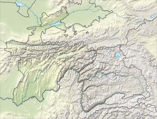
WThe 1997 Harnai earthquake occurred on February 27 at 21:08 UTC near Harnai, Pakistan, and felt throughout much of central Balochistan, with a magnitude estimated at 7.0 on the Mw scale. A 2016 study determined that this was a doublet earthquake, the Ms 6.4 shock that hit 22 minutes later being a continuation of the initial main shock. The earthquake was caused by the collision between the Indian Plate and the Eurasian Plate.
 W
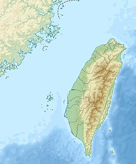
WThe 2006 Hengchun earthquakes occurred on December 26 at 20:26 and 20:34 local time off the southwest coast of Taiwan in the Luzon Strait, which connects the South China Sea with the Philippine Sea. The International Seismological Centre measured the shocks at 7.0 and 6.9 on the moment magnitude scale. The earthquakes not only caused casualties and building damage, but several submarine communications cables were cut, disrupting telecommunication services in various parts of Asia. Coincidentally, the earthquake occurred on the second anniversary of the 2004 Indian Ocean earthquake that devastated the coastal communities across Southeast and South Asia and 3rd anniversary of the 2003 earthquake that affected the southern Iranian city of Bam.
 W
WThe 1993 Klamath Falls earthquakes took place in Klamath Falls, Oregon, beginning on Monday, 20 September at 8:28 p.m. The doublet earthquake registered respective magnitudes of 6.0 and 5.9 on the moment magnitude scale. The earthquakes were located at a depth of 5.6 miles (9 km) and tremors continued to be felt more than three months after the initial shocks.
 W
WThe 2006 Kuril Islands earthquake occurred on November 15 at 8:14:16 pm JST with a Mw magnitude of 8.3 and a maximum Mercalli intensity of IV (Light). This megathrust earthquake was the largest event in the central Kuril Islands since 1915 and generated a small tsunami that affected the northern Japanese coast. The tsunami crossed the Pacific Ocean and damaged the harbor at Crescent City, California. Post-tsunami surveys indicate that the local tsunami in the central Kuril Islands reached runup of 15 metres (49 ft) or more.
WThe 2007 Kuril Islands earthquake occurred east of the Kuril Islands on 13 January at 1:23 p.m. (JST). The shock had a moment magnitude of 8.1 and a maximum Mercalli intensity of VI (Strong). A non-destructive tsunami was generated, with maximum wave amplitudes of 0.32 meters. The earthquake is considered a doublet of the 8.3 magnitude 2006 Kuril Islands earthquake which occurred the previous November approximately 95 km to the southeast.
WThe 1976 Songpan–Pingwu earthquake that struck Songpan and Pingwu counties in Sichuan, China consisted of three mainshocks on the 16th, 21st, and 23rd (UTC) of August. A 1984 report gave the magnitudes as 7.2, 6.7, and 7.2, resp.. The magnitudes were subsequently recalculated as 6.7, 6.3, and 6.4 on the Mw scale, and 7.0, 6.6, and 6.7 on the Ms scale. These were preceded by an earthquake swarm lasting three years. During the period from August 16 to August 31 there were over 400 aftershocks of magnitude 3.0 or greater.
 W
WOn July 29, the 2006 Tajikistan earthquake hit the Khatlon region of Tajikistan. The earthquake doublet killed three people and injured 19.