 W
WThe Southern Highlands, also locally referred to as the Highlands, is a geographical region and district in New South Wales, Australia and is 110 km south-west of Sydney. The entire region is under the local government area of the Wingecarribee Shire. The region is also considered a wine region.
 W
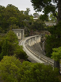
WThe Avon Dam is a heritage-listed dam in Avon, Wingecarribee Shire, New South Wales, Australia. It is one of four dams and weirs in the catchment of the Upper Nepean Scheme, providing water to the Macarthur and Illawarra regions, the Wollondilly Shire, and metropolitan Sydney. The arch dam across the Avon River was completed in 1927 under the supervision of Ernest Macartney de Burgh, the dam is currently managed by the Sydney Catchment Authority and is listed on the New South Wales State Heritage Register.
 W
WThe Bargo River, a watercourse of the Hawkesbury-Nepean catchment, is located in the Southern Highlands and Macarthur districts of New South Wales, Australia.
 W
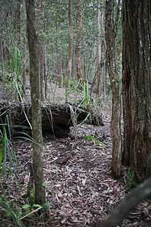
WThe Barren Grounds Nature Reserve is a protected nature park located in the Southern Highlands region of New South Wales, Australia. The 2,024-hectare (5,000-acre) reserve is situated east of Budderoo National Park, and west of the city of Kiama. The reserve can also be accessed from the south, via a local road and a bush walk from the town of Berry. It is not far from the Nameless Sylvan Reserve owned by Bush Heritage Australia.
 W
WBarrengarry Nature Reserve is a protected area of 21 hectares, situated in Barrengarry in the Illawarra region of New South Wales. The nearest town is Kangaroo Valley. The reserve endeavours to protect rainforest communities and eucalyptus forest. As well as populations of threatened species such as the eastern bristlebird, brush-tailed rock-wallaby and long-nosed potoroo.
 W
WThe Belmore Falls is a plunge waterfall with three drops on the Barrengarry Creek in the Southern Highlands and Illawarra regions of New South Wales, Australia.
 W
WBowral railway station is located on the Main South line in New South Wales, Australia. It serves the town of Bowral opening on 1 March 1867.
 W
WBurradoo railway station is located on the Main South line in New South Wales, Australia. It serves the town of Burradoo, opening in 1870.
 W
WThe Cambewarra Range Nature Reserve, as part of the Kangaroo Valley Group of Nature Reserves, is a protected area located on the cliffs and plateaus of the Kangaroo Valley in the Southern Highlands and South Coast regions of New South Wales in eastern Australia. The Reserve is situated approximately 150 kilometres (93 mi) south of Sydney, 50 kilometres (31 mi) southwest of Wollongong and 16 kilometres (9.9 mi) northwest of Nowra. The Reserve has a total area of 1684 hectares, and includes 11 privately owned properties. It is critical for it to be pristine for a variety of reasons, not the least the catchment of water, as the Reserve floor flows into the Kangaroo Valley River and the Shoalhaven River, from which the Sydney Water Authority draws water to supply large populations in Sydney and Wollongong.
 W
WThe Cataract Dam is a heritage-listed dam in Cataract, New South Wales, Australia, provides water to the Macarthur and Illawarra regions, the Wollondilly Shire, and metropolitan Sydney. It is one of four dams and weirs in the catchment of the Upper Nepean Scheme. Completed in 1907 under the supervision of Ernest Macartney de Burgh, the dam is currently owned by Water NSW, an agency of the Government of New South Wales. The dam was listed on the NSW State Heritage Register on 18 November 1999.
 W
WThe Cecil Hoskins Nature Reserve is a protected nature reserve located in the Southern Highlands area of New South Wales Australia. The 46-hectare (110-acre) reserve is situated between the towns of Bowral and Moss Vale and is known for bird watching.
 W
WThe Cordeaux Dam is a heritage-listed dam in Cordeaux, New South Wales, Australia. It provides water to the Macarthur and Illawarra regions, the Wollondilly Shire, and metropolitan Sydney. It is one of four dams and weirs in the catchment of the Upper Nepean Scheme. Completed in 1926 under the supervision of Ernest Macartney de Burgh, the dam is owned by Water NSW, an agency of the Government of New South Wales. It was listed on the New South Wales State Heritage Register on 18 November 1999.
 W
WThe Fitzroy Iron Works at Mittagong, New South Wales, was the first commercial iron smelting works in Australia. It first operated in 1848.
 W
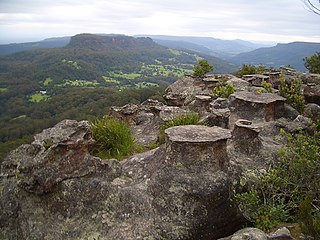
WFlying Fox Pass is a locality in the Barren Grounds Nature Reserve in New South Wales, Australia, overlooking the Kangaroo Valley. It is the site of a former flying fox cablecar which lifted valuable timber from the valley to be transported by road and rail systems. Little remains of the flying fox, just a cement plinth and rusted remnants of the wire and winching equipment. A walking track extends to the pass, but dense vegetation growth precludes any vista from the site.
 W
WThe Gundangara are an Aboriginal Australian people in south-eastern New South Wales, Australia. Their traditional lands include present day Goulburn and the Southern Highlands.
Group 6 is a senior Rugby league competition in New South Wales, Australia, run under the auspices of the Country Rugby League. The geographical area covered by Group 6 takes in much of the Southern Highlands and southern Macarthur regions of New South Wales, extending from Marulan, New South Wales in the south, to Mount Annan/ the M5 in the north and Warragamba in the west.
 W
WHill Top is a former railway station which was located on the Picton – Mittagong loop railway line. It served the small town of Hill Top, a Northern Village of the Southern Highlands of New South Wales, Australia.
 W
WThe Kangaroo River is a perennial river of the Shoalhaven catchment located in the Southern Highlands and Illawarra regions of New South Wales, Australia.
 W
WThe Kangaroo River Nature Reserve, part of the Kangaroo Valley Group of Nature Reserves, is a protected nature reserve that is located on the floor of the Kangaroo Valley in the Southern Highlands and South Coast regions of New South Wales in eastern Australia. The reserve is situated approximately 150 kilometres (93 mi) south of Sydney, 50 kilometres (31 mi) southwest of Wollongong and 16 kilometres (9.9 mi) northwest of Nowra. The reserve has a protective covenant placed upon it with purpose to ensure the protection of the natural heritage of this area. National parks in the area include the Morton National Park and the Budderoo National Park. Other nature reserves in the area include the Barren Grounds Nature Reserve, and the Cambewarra Range, Barrengarry and Rodway nature reserves – the latter three part of the Kangaroo Valley Group of Nature Reserves.
 W
WMacquarie Rivulet is a perennial river located in the Southern Highlands and Illawarra regions of New South Wales, Australia.
 W
WThe Mittagong Maltings was a large three-malthouse complex first established in 1899 by the Malting Company of New South Wales, Australia, to supply malt to breweries throughout the state. The Maltings site is listed as a local council heritage item.
 W
WMount Broughton is a historic house located in Sutton Forest, New South Wales, Australia. It is run commercially as Peppers Manor House. The house was built in 1878 by Henry Edward Kater and was the rural retreat for the Kater family for almost one hundred years. In 1984 it was renovated and major extensions were made to convert it to a hotel and conference centre.
 W
WThe Nattai National Park is a protected national park that is located in the Macarthur and Southern Highlands regions of New South Wales, in eastern Australia. 48,984-hectare (121,040-acre) It is situated approximately 150 kilometres (93 mi) southwest of the Sydney central business district and primarily encompasses the valley of the Nattai River, which is surrounded by spectacular sandstone cliffs. The park is covered in dry sclerophyll forest - mostly eucalypt and has fairly frequent forest fires. It is largely an untouched wilderness area and receives very few visitors, as it has virtually no facilities and is fairly remote, despite its proximity to Sydney.
 W
WThe Nattai River, a perennial river that is part of the Hawkesbury-Nepean catchment, is located in the Southern Highlands region of New South Wales, Australia.
 W
WThe Nepean Dam is a heritage-listed dam split across Avon in the Wingecarribee Shire and Bargo in the Wollondilly Shire, both in New South Wales, Australia. The reservoir created by the dam spreads across Avon, Bargo and also Yerrinbool in Wingecarribee Shire. The Nepean Dam is one of four dams and weirs in the catchment of the Upper Nepean Scheme, in New South Wales, Australia, and provides water to the Macarthur and Illawarra regions, the Wollondilly Shire, and metropolitan Sydney. Completed in 1935 under the supervision of Ernest Macartney de Burgh, the dam is currently managed by the Sydney Catchment Authority and is listed on the New South Wales State Heritage Register.
 W
WNepean River, is a major perennial river, located in the south-west and west of Sydney, New South Wales, Australia. The Nepean River and its associated mouth, the Hawkesbury River, almost encircles the metropolitan region of Sydney.
 W
WPenrose railway station is located on the Main South line in New South Wales, Australia. It serves the village of Penrose opening in 1869 as Cables Siding being renamed Penrose on 1 June 1871. It was relocated to its present site on 15 March 1916.
 W
WThe Robertson Nature Reserve is a protected rainforest nature reserve that is located in the Southern Highlands region of New South Wales, in eastern Australia. The 5.3-hectare (13-acre) reserve is situated near Robertson on the edge of the Illawarra Escarpment and is a remnant of the Yarrawa Brush, once 2,450 hectares in size.
 W
WThe Warragamba River, a river that is part of the Hawkesbury-Nepean catchment, is located in the Macarthur region of New South Wales, Australia.
 W
WThe Wingecarribee River, a perennial river that is part of the Hawkesbury–Nepean catchment, is located in the Southern Highlands region of New South Wales, Australia.
 W
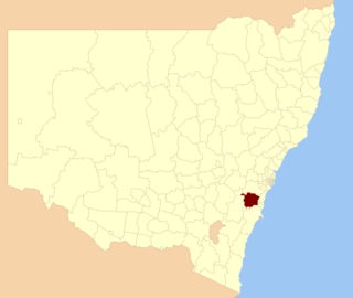
WWingecarribee Shire is the local government area of the Southern Highlands in the state of New South Wales, Australia. The Wingecarribee Shire is around 110 kilometres (70 mi) southwest of the Sydney central business district and is part of regional Capital Country and to some extent can be considered part of the Southern Tablelands.
 W
WWollondilly Anglican College is a Pre-Kindergarten to Year 12 co-educational private school operated by The Anglican Schools Corporation. Located in the Wollondilly Shire, the College services families and communities from areas such as the Southern Highlands, Picton, Camden, Campbelltown and beyond.
 W
WThe Wollondilly River, an Australian perennial river that is part of the Hawkesbury–Nepean catchment, is located in the Southern Tablelands and Southern Highlands regions of New South Wales. The river meanders from its western slopes near Crookwell, flowing south-east through Goulburn, turning north-east to near Bullio, flowing north-west to Barrallier, before finally heading north-easterly into its mouth at Lake Burragorang.
 W
W W
W